Weekly Outlook: April 9-15, 2018

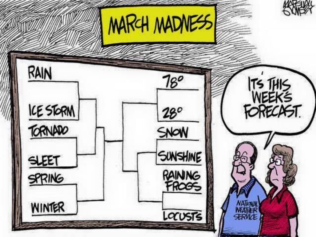
Since it seems like winter doesn’t want to end, a question we’ve been asked lately is “when is it going to finally warm up”? If you believe some of the guys on TV or the Facebook Forecasters,  then the answer is “the end of this week.” However, we’re not so sure about that. Not yet, at least.

MonthTDeptNRCC
The first week of April has seen temperatures average several degrees below normal across the Northeast. Image provided by the Northeast Regional Climate Center

We start the week off with an area of high pressure keeping us dry on Monday. Tuesday will feature plenty of clouds along with some snow or rain showers as a weak system moves across the region. High pressure returns on Wednesday, with dry and cool conditions once again. The end of the week is where things get iffy.

On Thursday, low pressure moving into the Great Lakes will send a warm front towards the region. Some showers are likely ahead of this warm front, meaning Thursday will be a gray and possibly damp day. If the warm front does come through, and that’s far from certain right now, a cold front will move through at night as that low pressure system passes north of the region. That cold front will likely stall out south of New England. This leads to our next problem. Does it head northward again as a warm front?

14-km EPS Global KNZW SOUTH WEYMOUTH 15-day Daily Temperature
How uncertain is the late-week warmth? Using this chart which is based on the ECMWF Ensemble forecast for South Weymouth, MA, the high temperature on Saturday could be anywhere from 41 to 76, with a mean of 62. Sunday is nearly as bad with a range of 38 to 70 with as mean of 57. Image provided by Weathermodels.com

Another storm system will move into the Midwest towards the end of the week. Some of the models are trying to have that system lift the front northward again, bringing very mild air into the region later Friday into Saturday. This is certainly possible. However, we’ll have plenty of cold air in place to the north, plus some very cold water off to our east. If you’ve lived here long enough, you know that warm weather doesn’t last too long around here, especially in April. Adding to our doubts is the fact that the models have the storm pass north and west of Chicago. A noted colleague once pointed out to us that with storms passing north and west of Chicago, warm fronts have plenty of trouble making northward progress around here, as they become too far removed from the main system, and lose the push that they need to head northward. This is more obvious in the winter, but since we’re still in a winter-type pattern, we’re taking note of that observation.

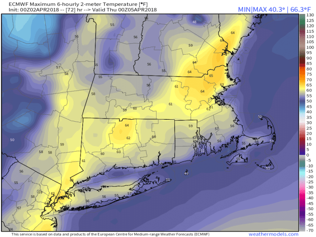
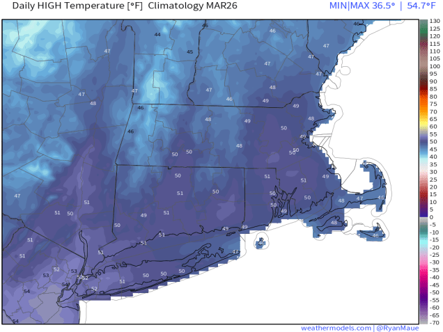
Finally, we get to Sunday. This is where things REALLY get complicated. If our warm front comes through, it’ll likely start heading southward again later Saturday as colder air tries to push back in. This could set us up for a VERY chilly Sunday. At the time this forecast was written early Monday morning, one model kept temperatures in the middle 30s to lower 40s all day Sunday, another kept temperatures in the 40s to lower 50s, while a third model had temperatures in the upper 60s and 70s (see maps below). So, there’s plenty of uncertainty. Meanwhile, another cold front will be approaching from the west, and low pressure will be riding out of the Gulf of Mexico along that front. That means that clouds and a few showers are likely. As the low pressure area gets nearer, we could be in for a period of heavy rain, but the timing of that, as well as the actual cold front, are still big question marks. The heavy rain could move in for Sunday night, it might move in Monday morning, or it might hold off until Monday night. Since next Monday is Patriots Day, this makes a BIG difference. We’ll know more on that later in the week.


Monday: Sunshine dimmed by thickening clouds in the afternoon. High 40-47.

Monday night: Partly to mostly cloudy. Low 27-34.

Tuesday: Mostly cloudy with some rain or snow showers possible. High 41-48.

Tuesday night: Becoming mostly clear. Low 25-32.

Wednesday: Sunshine and some afternoon clouds. High 47-54.

Thursday: Mostly cloudy and breezy with a few showers possible. High 51-58.

Friday: Partly to mostly cloudy, chance for a few showers. High 57-64, cooler along the South Coast.

Saturday: Intervals of clouds and sunshine, breezy, and warm. High 60-67, cooler along the South Coast. Temperatures may drop sharply in the afternoon from southern New Hampshire into eastern Massachusetts.

Sunday: Partly to mostly cloudy and breezy, more showers possible, especially late in the day. High 45-52, possibly milder south of Boston.

Weekly Outlook: April 2-8, 2018

We’ve got a lot of different types of weather coming up this week, starting with some snow today, and that’s not an April Fools joke.

The week actually starts off with some light snow for parts of the area. A storm system will pass south of New England today, with a period of light snow likely during the morning, mainly south of Route 2. This will not be a big deal, as there are several factors working against this system.

  1. It will be fast-moving, with snow moving in around the morning rush hour and ending around midday.
  2. Temperatures will be near or above freezing when most of the precipitation falls.
  3. Since it’s early April,, the sun angle is high enough that it’ll be tough to accumulate on paved surfaces unless it comes down very hard.
  4. Dry air in place at the start will evaporate some of the snow before it hits the ground.

Add up all those factors, and you don’t much snow accumulation. In fact, we’re only expecting 1-2 inches on grassy surfaces, mainly from Boston southward. A few places could pick up 3 inches, but that’s about it. Not a big deal.

snku_acc.us_ne (1)
The GFS snowfall forecast is probably closest to our thinking for today’s snow. Image provided by Pivotal Weather.

Skies clear out during the afternoon, but clouds quickly come back in at night as a warm front starts to approach the region on Tuesday. We’ll have rain moving back in during the afternoon and evening, possibly mixed with a little wet snow in a few spots. The warm front comes through overnight, with temperatures rising after midnight. Wednesday will be a cloudy and mild day, but a cold front will be approaching from the west. This will produce more showers and maybe even a thunderstorm. Temperatures drop quickly behind the front Wednesday evening.

9-km ECMWF USA Surface Mass & CT & RI 2-m Maximum Temperature 72
Wednesday is looking like a mild day before the cold front arrives with showers in the afternoon. Image provided by Weathermodels.com

This brings us to the most important day of the week – Thursday. Why is Thursday the most important day? It’s the Red Sox home opener at Fenway! Last year, the opener was on April 3, against the Pittsburgh Pirates, and it was, partly cloudy, breezy, and 48 degrees at game time. This year, it’ll be partly cloudy and breezy once again, but it’s probably not going be 48 degrees at game time. We’ll probably need to shave about 3 or 4 degrees off of that. If you have tickets, dress like you’re going to a Pats game in November.

Hyannis

Clouds stream back in later in the day as another weak system approaches. This system will bring in some light rain or snow Friday into early Saturday, but again, this will not be a big deal, with little to no accumulation expected. High pressure then builds back in later on Saturday and into Sunday. Having said that, some of the models are showing the potential for a storm system to impact the region on Sunday. We’re not ready to jump on board with this just yet, but it would not be unprecedented. Most of us remember the April Fools Day storm from 1997, but how many people remember the April 6-7, 1982 storm? Temperatures stayed in the teens and 20s during that storm. We also had back-to-back storms April 7-8 and April 9-10 in 1996, which dropped a combined 8-20 inches of snow on the area. If this storm starts looking more likely, we’ll let you know later in the week.

19820406-19820407-3.35
Snowfall totals from the April 6-7, 1982 snowstorm. Image provided by NOAA.

Monday: Light snow likely in the morning, mainly south of Route 2, then some sunshine may return in the afternoon. High 39-46.

Monday night: Partly cloudy in the evening, then becoming cloudy again after midnight. Low 27-34.

Tuesday: Mostly cloudy with showers developing in the afternoon. High 41-48.

Tuesday night: Cloudy and breezy with occasional showers. Low 36-43 in the evening, then temperatures rise after midnight.

Wednesday: Windy and mild with more showers possible, maybe even a rumble of thunder. High 57-64, coolest along the South Coast.

Thursday: Partly to mostly sunny, breezy, and colder. High 39-46.

Friday: Mostly cloudy and breezy with some light rain or snow possible, especially late in the day and at night. High 44-51.

Saturday: Chance of light rain or snow early, then becoming partly sunny. High 37-44.

Sunday: A mix of sun and clouds. High 40-47.

Weekly Outlook: March 26-April 1, 2018

March certainly came in like a lion, but true to form, it’s probably going out like a lamb. After a very active month, much of the upcoming week will feature some rather benign weather.

The week starts out with high pressure to our north and northeast, meaning dry but cool conditions for Monday and Tuesday. Of course, cool is a relative term, since “cool” late March means 40s for highs, as opposed to teens and 20s in January. That also means that we’ll continue to melt this persistent snow cover that we’ve had. Of course, with melting during the day and temperatures dropping below freezing at night, the potential exists for some black ice, so use a little caution if you’re heading out during the next few evenings.

t2max_massachusetts_MAR26
High temperatures should be right around 50 for the final week of March. Image provided by Weathermodels.com

For Wednesday, a weak system moves across the region, bringing us some scattered showers. If the precipitation moves in early enough, which is a possibility, we could see a little freezing rain or some sleet Wednesday morning, especially from the Merrimack Valley into southern New Hampshire.

gfs_ptype_slp_boston_11
Some freezing rain is possible across southern New Hampshire and the Merrimack Valley as precipitation moves in Wednesday morning. Im age provided by WeatherBell.

This brings us to Thursday, which will be a sure sign for many of you that Spring has finally arrived. Sure, it’ll be dry and mild. Temperatures should be well into the 50s across the area. More important than that – it’s Opening Day. The 2018 regular season begins for the Boys of Summer. When Chris Sale steps to the mound at Tropicana Field, the fans there won’t see a single cloud in the sky, but that’s because it’s a domed stadium and you can’t see the sky from inside the park. Around here, if you’re tuning into NESN or WEEI, it should be a fantastic day to leave work a little early (first pitch is at 4pm), and enjoy the fact that baseball is back. In fact, Thursday will feature a Boston/Tampa doubleheader on NESN. No, not two baseball games, but right after the Sox and Rays play, the Bruins and Lightning will faceoff at the Garden with 1st place in the Eastern Conference on the line. If you’re a fan of both hockey and baseball (like we are here at StormHQ), then there aren’t too many days on the calendar better than Thursday.

bb0b824c41c4429a86575f2bb382f3bb

Back to the weather, Friday will still be mild, but also wet, as a storm system passes north and west of the region. Of course, given the way this past winter has gone, we wouldn’t be surprised if that storm trended farther south and east, and we end up cooler, but for now, we’ll remain optimistic.

Behind the system, we should remain seasonably mild on Saturday, with showers ending in the morning but Sunday is the day with questions. At least one model wants to bring another system right in with windy, wet, and warmer conditions, while another model wants to build a high pressure system in with sunshine and seasonable conditions. Once again, we’ll remain optimistic, but be forewarned, you may need umbrellas for your Easter or Passover plans.

Monday: Clouds linger across Cape Cod, becoming partly to mostly sunny elsewhere. High 37-44.

Monday night: Clear to partly cloudy. Low 22-29.

Tuesday: Sunshine to start, then high clouds filter in during the afternoon. High 41-48.

Tuesday night: Becoming cloudy, showers developing late at night, possibly starting as some freezing rain in the Merrimack Valley and southern New Hampshire. Low 27-34.

Wednesday: Cloudy with scattered showers likely. High 41-48.

Thursday: Plenty of clouds with a few sunny breaks. High 54-61, cooler right along the South Coast.

Friday: Cloudy and breezy with showers likely. High 50-57.

Saturday: Showers ending in the morning, some sunshine develops in the afternoon, breezy. High 48-55.

Sunday: A mix of sun and clouds. High 45-52.

Weekly Outlook: March 19-25, 2018

640e4da1ddcc677489803612adff60bd--nc-weather-march-madness

To many of you, March Madness started this past weekend, and by now, your bracket is busted. For some of you, March Madness has been going on for a couple of weeks, and you’ve got trees and other things that are busted. Will the Madness continue? It looks like it may, for at least part of the region.

The week starts off with high pressure in control, so we have another dry but chilly day for Monday. Clouds start to stream in on Tuesday as low pressure moves off the Mid-Atlantic coastline. Unlike most of the storms that have impacted us this month, this storm should slide off to our south, with little to no impact on New England this time. However, another storm quickly follows behind that one, and this one should be a bit farther north and west, meaning that at least parts of the region will see some impact. There is still many questions about the exact track this storm will take and how strong it will be, so we’ll likely have a special post later in the week about it, but for now, we have some preliminary ideas.

It looks like a period of light snow is expected from Wednesday morning into Thursday morning across the area. The snow is most likely across southeastern Massachusetts, but could extend as far inland as southern New Hampshire and central Massachusetts. There’s also the chance that some rain could mix in across Cape Cod. These are the type of details we won’t be able to resolve until sometime on Tuesday most likely. One thing we are fairly certain of is that another period of strong winds is likely across eastern Massachusetts, especially along the coast. Tides are astronomically high again this week, so coastal flooding will be a concern at high tide, especially the high tides early Wednesday and Thursday morning, as well as Wednesday afternoon.

nam_mslp_uv10m_boston_26
Sustained winds of 20-40 mph with gusts to 60 mph are possible Wednesday into early Thursday along the coastline. Image provided by WeatherBell.

The storm starts to pull away Thursday afternoon, but with an upper-level low pressure system moving through, plenty of clouds are likely into Friday, with a few flurries possible. High pressure briefly builds in for Saturday with some sunshine, but clouds quickly return in the afternoon as the next system starts to approach. As for that system on Sunday, the usual caveats apply – it’s seven days away, there’s a ton of uncertainty, things can and will change, yadda, yadda, yadda.

Monday: Sunshine and a few clouds. High 32-39.

Monday night: Clear in the evening, then high clouds start to stream in late at night. Low 14-21.

Tuesday: Thickening clouds. High 33-40.

Tuesday night: Mostly cloudy and becoming breezy. Chance for light snow towards daybreak along the south coast. Low 21-28.

Wednesday: Cloudy and breezy with light snow likely, possibly mixing with rain across Cape Cod. High 30-37.

Thursday: Light snow ending early, a few sunny breaks may develop in the afternoon, still breezy. High 37-44.

Friday: More clouds than sunshine, chance for a flurry. High 38-45.

Saturday: Sunny to start, clouds return in the afternoon. High 37-44.

Sunday: Mostly cloudy and breezy with a chance of snow or rain. High 32-39.

Weekly Outlook: March 12-18, 2018

ee3

Another week, another nor’easter. Once again, the hype train has left the station and is heading down the track at top speed. Without further delay, let’s get right to it.

Low pressure moving across the Tennessee Valley Sunday night will redevelop off the South Carolina coastline early Monday, then head up the East Coast. The storm will pass south and east of Cape Cod while rapidly intensifying. As is usually the case, this will bring strong winds and snow to the region. Obviously, the strength of the winds and the amount of snow will be dependent on how close the storm passes to New England, among other things. As you probably heard on Sunday, the vast majority of media outlets, as well as all of the Facebook Forecasters, and even the National Weather Service, are calling for very heavy snowfall from this storm. The reason for this is that many of the models are forecasting these amounts. Well, as a noted colleague has said in the past – “If the models were as good as everyone thinks, there would be no need for meteorologists”. Oh, we still think there will be some heavy snow, and we’re expecting plowable amounts, but let’s pump the brakes on the talk of “1-2 feet” or “12-18 inches”, or our personal favorite cop-out “10-14 inches+” (adding the plus so that if anything higher than that falls you can claim that your forecast was accurate).

gfs_mslp_pcpn_frzn_neus_fh12-72
GFS forecast for the progression of the storm on Tuesday. Loop provided by Tropical Tidbits.

Before the storm arrives, Monday will be a generally cloudy day, with temperatures right around where they should be in mid-March. Winds will start to pick up in the evening, and for most of the day on Tuesday, we’re looking at northeast winds of 20-30 mph, with gusts to 40-50 mph inland, and 60-70 mph at the coast. Yes, this may take down some additional trees, but coastal flooding will not be a problem this time, as tides are significantly lower than they were a week ago.

As for the snow, it should develop around midnight, give or take an hour or two, and quickly become steady and heavy. Heavy snow will continue into the morning, then lighten up a bit in the afternoon, winding down in the evening.  If you can work from home on Tuesday, we’d recommend it. Travel will be extremely difficult in the morning, as snow could be falling at the rate of an inch an hour or more, and it will be accompanied by strong winds, creating blizzard conditions at times.

95fa3e39-3af5-4e35-9857-7b00c3643445_1000
Official definition of a blizzard. Note, snowfall accumulations do not factor into this. Image provided by WCVB-Boston.


As for how much, well, as we mentioned above, we’re not going with the big amounts that many others are. Why? Well, for one, a portion of that snow is going to fall during the daytime. At this time of year, the sun angle is strong enough (equivalent to the end of September), then unless it’s falling heavily, it will have trouble accumulating. Now, it will be falling heavily in the morning, but probably not as heavily in the afternoon. So, you can slice a little off of those model snow maps right there. Another reason is that we expect the models to shift a little more with the track slightly farther offshore. That has been the trend during the day today, and if that continues, it will result in lighter amounts. Yes, unlike the Facebook Forecasters who just take the what the models say exactly and call it a forecast, we use experience and education to figure out where the models are likely in error, and adjust accordingly. As for amounts, that likely means a general 8-12 inches across most of the region, with isolated heavier totals, especially across southeastern Massachusetts and the Cape. Across the Outer Cape and Nantucket, there is the possibility of some rain mixing in, which would keep accumulations lower.

snku_acc.us_ne (3)
The snowfall forecast from the Sunday late-afternoon run of the GFS is closest to our thinking for the next storm. Image provided by Pivotal Weather.

Once the system pulls away, an upper-level low will move into the region on Wednesday, keeping plenty of clouds in place, with some additional snow showers possible. The upper-level low may linger into Thursday, with only a little more sunshine, and a slightly lower chance for snow showers. High pressure finally starts to build in for Friday and Saturday. By Sunday, the next system approaches the region. Right now, this system looks warmer, with rain, but given the way this month has gone, does anyone wanna bet that it stays that way? Anyone? Anyone? Bueller? Bueller?

Monday: Any early sunshine disappears behind increasing clouds. High 37-44.

Monday night: Becoming windy with snow developing, becoming heavy at times. Low 26-33.

Tuesday: Windy with snow, heavy at times in the morning, tapering off late in the day. High 29-36.

Tuesday night: Snow ending in the evening, remaining mostly cloudy with winds gradually diminishing. Low 24-31.

Wednesday: Partly to mostly cloudy and breezy with more snow showers developing. High 32-39.

Thursday: More clouds than sunshine, breezy, chance for a few snow showers. High 34-41.

Friday: A mix of sun and clouds, still breezy, slight chance for another snow shower. High 33-40.

Saturday: Partly to mostly sunny. High 37-44.

Sunday: Becoming cloudy with a chance of rain or snow showers. High 41-48.

Weekly Outlook: March 5-11, 2018

The cleanup continues after Friday’s powerful storm, but guess what? There’s another one coming! We do have good news and bad news though. The good news is that this one won’t be a strong, will contain less precipitation, the winds won’t be a strong, and the tides won’t be as high. The bad news? It’ll be colder, so many of you could be seeing some snow from this storm, potential a lot of it.

March2Winds
Friday’s storm is still producing gusty winds across the area today, but they are nothing compared to what the system produced on Friday. Image provided by the National Weather Service office in Taunton, MA.

Friday’s storm is still impacting the region today, but it will finally move away late in the day. A disturbance rotating around the system produced some light snow and snow showers overnight into this morning, and winds remain gusty at times, though not nearly to the magnitude of Friday. As the storm pulls away, high pressure builds in later today and tomorrow with drier and seasonably cool conditions.

YearPNormNRCC
The calendar year is off to a very wet start across most of Central and Southern New England and into the Mid-Atlantic states, and Wednesday’s storm will only add to that. Image provided by the Northeast Regional Climate Center.

As we head into Wednesday, things go downhill again. Low pressure moving across the Ohio Valley will start to weaken while a secondary area of low pressure develops off the North Carolina or Delmarva shoreline. This system will strengthen as it heads northeastward. Another period of gusty winds is likely Wednesday into early Thursday, but this time we’re talking about wind gusts of 40-50 mph along the coast, not 70-90 mph. The system will also spread precipitation into the region. Temperatures will be a little colder, so parts of the region will see snow, possibly significant snowfall. The big question is, how far inland does the rain/snow line penetrate? Some models bring it into the 128 or 495 belts. At least one model brings it all the way into southern New Hampshire. We should have some clarity on this over the next 24-36 hours, and we’ll have a special blog post Tuesday afternoon with our updated outlook on the storm. For now, the current thinking is that from Boston southward, this is mainly rain with some snow possible, north and west of Boston, some accumulation is likely, with significant accumulations possible, especially the farther north and west you go.

namconus_ref_frzn_neus_fh54-84
Forecast for the midweek storm from the NAM model. Loop provided by TropicalTidbits.

Everything winds down early Thursday, but with an upper-level low pressure system moving through, some additional rain or snow showers are possible later Thursday and Friday. High pressure then builds in for the weekend, but by late Sunday, we’ll need to keep our eyes on a system moving into the Mid-Atlantic states that could impact us on Monday. We’ll worry about that system later in the week.

Monday: Mostly cloudy and breezy with some lingering snow or rain showers, mainly early. High 36-43.

Monday night: Becoming partly cloudy. Low 25-32.

Tuesday: A mix of sun and clouds. High 35-42.

Tuesday night: Becoming mostly cloudy, chance for snow showers towards daybreak. Low 25-32.

Wednesday: Windy with snow likely, changing to rain from Boston southward, possibly north and west of Boston as well. High 33-40.

Thursday: Snow or rain tapers off early, otherwise mostly cloudy and breezy. High 36-43.

Friday: More clouds than sunshine, breezy, chance for some snow or rain showers. High 36-43.

Saturday: Partly to mostly sunny and breezy again. High 37-44.

Sunday: A sunny start, then clouds start to stream in during the afternoon. High 41-48.

Weekly Outlook: February 26-March 4, 2018

Yup, the hype train has left the station again and is rolling down the track. You may have heard that there’s a storm coming later this week. We’ll set the record straight between hype and reality, fact and fiction, in this outlook.

The first half of the week, also known as the last 3 days of February (and the last 3 days of meteorological winter) will actually be quite pleasant. High pressure will be in control with sunshine and mild temperatures. It’s not the early taste of spring that we had a week ago, but we doubt there will be many complaints. After that, things start to get complicated.

GEFS Ensembles North America 500 hPa Height 120
By the end of the week, a “blocking” pattern will set up. The large upper-level high pressure area over Greenland will slow down the progression of storms eastward across the Eastern U.S. Image provided by Weathermodels.com

A “blocking” pattern will set up across the Eastern US. Normally, the jet stream flows west to east, steering storms across the country. When there’s a dip in the jet stream (a trough), we tend to have colder than normal temperatures, along with stormier conditions. We’ll have one of those troughs move into the East later this week, and it will eventually break off from the jet stream (called a “cut-off low”). At the same time, a large upper-level high pressure area will set up shop over Greenland. This will block the eastward progression of storms, meaning that the storm we’re expecting later this week won’t be in a hurry to leave. However, it could also be a good thing. How? If the ridge of high pressure continues to build in, it could deflect that storm farther to the south. Good for us, but bad for places like New York City, Philadelphia, or even Washington.

gfs-ememb_lowlocs_eus_21
The GFS Ensemble forecast for Friday evening shows the wide range in possible solutions. The mean solution is for a 987mb low centered east of Virginia Beach and south of Nantucket. The red numbers are the locations of the various ensemble members and their strength in millibars (add a 9, so 74 is really 974mb). Image provided by Tropical Tidbits.

The models still haven’t come to a consensus on what will happen for the end of the week. There are several things that we need to figure out before we can come up with a forecast that we’ll have any confidence in. What are those factors? Where will the low pressure area track? How strong will it be? How much cold air will be in place before the storm arrives and when it’s impacting the region? How strong will that high pressure area to the north be?  These details will likely take a few more days to be resolved. So, if you hear others, especially in the media, talking about the “3-day storm” or the “snowstorm” that will impact us later this week, take it with a giant grain of salt. Nobody, including us, can say with any degree of confidence, what will happen. We could have heavy rain, heavy snow, strong winds, or all of the above. The only thing we can be reasonably confident about is the fact that some coastal flooding seems likely. The highest tides of the month are expected at the end of the week, and with a storm of some sort off the East Coast, that will likely lead to some coastal flooding across parts of the area. Things should start to improve over the weekend, but even that will depend on the progression of the storm.

gfs_mslp_uv10g_boston_20
The potential exists for wind gusts of 30-60 mph across the region from the storm, especially along the coast, with even stronger winds across Cape Cod and the Islands. Image provided by WeatherBell.

Monday: Early clouds, then becoming mostly sunny and mild. High 47-54.

Monday night: Clear skies. Low 26-33.

Tuesday: Plenty of sunshine. High 46-53.

Tuesday night: Clear to partly cloudy. Low 31-38.

Wednesday: Some early sun, then clouds filter in as the day goes on. High 52-59.

Thursday: Mostly cloudy and becoming breezy with some rain or snow possible late in the day and at night. High 46-53.

Friday: Windy with rain or snow possible. High 35-42.

Saturday: Windy with a chance for more rain or snow, especially early. High 36-43.

Sunday: More clouds than sun, breezy, chance for a few snow or rain showers. High 35-42.

Weekly Outlook: February 19-25, 2018

70 degrees. In July, that’s a chilly high temperature. In February, it’s a record breaker. We’re going to be challenging and possibly breaking some records this week. Don’t get too used to it though, as our early taste of Spring will be short-lived.

gfs_z500_mslp_atl_11
With a ridge of high pressure aloft along the East Coast and a Bermuda High at the surface, we’re looking at a couple of mild days Tuesday and Wednesday. Image provided by Tropical Tidbits.

The week starts out with a warm front moving towards the region, spreading in some clouds, and eventually showers on Monday. The front moves through Monday night, then a Bermuda High sets up shop for a couple of days, with unseasonably mild conditions expected for Tuesday and especially Wednesday. How mild? Most locations should reach the upper 50s to middle 60s on Tuesday. On Wednesday, most places should get into the 60s, with some lower 70s possible, especially north and west of Boston. Of course, there is an exception. Along the South Coast, the southwest winds that will bring warmer air in for the rest of us will be blowing in off of water that is still in the 30s. So, these locations will likely stay in the upper 40s and 50s both days. Still nice, but it’s not 60s and 70s.

Record0221
Record High Temperatures across the region for Wednesday February 21. It’s a safe bet that many of these records will fall. Data provided by the Northeast Regional Climate Center. For a complete list of the cities on this map with the record high data, open this PDF file.

A cold front moves through Wednesday night, bringing a few showers with it, but also bringing an end to the mild weather. Showers may linger along the south coast into early Thursday before the front pushes offshore, then high pressure builds in from the north with much cooler conditions for Thursday and Friday. Of course, “much cooler” is relative, as these temperatures will still be near to a little above normal for late February. Another storm system then moves in from the west, with some precipitation likely late Friday into Saturday. It should fall mostly as rain, but a period of snow or freezing rain is possible, especially across the Merrimack Valley and southern New Hampshire Friday night into Saturday. We’ll keep an eye on this situation as the week goes on. Another system quickly follows with more rain or snow on Sunday.

gfs_ptype_slp_boston_22
At least one model (in this case the GFS) is showing the potential for a wintry mix Friday night as a storm system moves through. Image provided by WeatherBell.

Monday: Becoming mostly cloudy and breezy with showers possible late in the day. High 42-49.

Monday night: Showers likely in the evening, otherwise mostly cloudy and breezy. Low 39-46 in the evening, then temperatures rise overnight.

Tuesday: Becoming partly sunny, breezy, and milder. High 57-64, except 49-56 along the South Coast and across Cape Cod.

Tuesday night: Partly to mostly cloudy. Low 46-53.

Wednesday: Partly sunny, breezy, and warm. Showers possible at night. High 65-72, except 49-64 along the South Coast and across Cape Cod.

Thursday: Clouds gradually giving way to some sunshine late in the day, turning much cooler. High 41-48.

Friday: A sunny start, then clouds return. Showers likely at night, possibly starting as some snow or freezing rain in the Merrimack Valley and Southern New Hampshire. High 37-44.

Saturday: Mostly cloudy and turning milder with a chance of showers, possibly some wintry mix early in the day across southern New Hampshire. High 47-54.

Sunday: Cloudy and breezy with a chance of rain or snow. High 36-43.


Weekly Outlook: February 12-18, 2018

Arctic Outbreaks. Blizzards. Sub-zero wind chills. These things are common around here in the month of February. None of them will be in the forecast this week. In fact, this week will be rather quiet and, believe it or not, mild (for the most part).

The week starts off with a cold front pushing offshore and high pressure building into the Northeast. Any lingering showers will end in the morning, but skies will only gradually clear out. Monday night and Tuesday will be clear and chilly as the high settles in. As the high moves offshore, milder conditions are expected on Wednesday, but clouds will also start to move in as a cold front starts to slowly approach from the west. Thursday will be a cloudy and mild day, with a few showers possible. The front finally pushes through on Friday with some rain and cooler conditions expected. High pressure returns for the weekend with dry and cooler conditions once again.

snku_acc.us_ne
Snowfall forecast from the GFS model between late Sunday night and next Sunday night. Notice that except for the Berkshires, no snow is forecast across Southern New England. Image provided by Pivotal Weather.

Monday: Some lingering showers near the South Coast early in the day, otherwise cloudy in the morning, with clearing in the afternoon. High 40-47, except for southeastern Massachusetts and Cape Cod where temperatures will start the day 48-55 then drop.

Monday night: Becoming mostly clear. Low 16-23.

Tuesday: Plenty of sunshine, clouds start to move back in late in the day. High 29-36.

Tuesday night: Partly to mostly cloudy. Low 21-28.

Wednesday: Early clouds, then becoming partly to mostly sunny and milder. High 41-48.

Thursday: Chance for some showers early, otherwise partly to mostly cloudy and mild. High 52-59.

Friday: Some morning showers, then gradual clearing, breezy, and turning cooler. High 46-53 early, then temperatures drop in the afternoon.

Saturday: Sunshine and some afternoon clouds. High 29-36.

Sunday: Mostly sunny. High 40-47.

JetBluePark
It’s a little less than 1500 miles to Fort Myers, but it’ll feel like Spring around here this week as pitchers and catchers report to Spring Training. Image provided by Redsox.com

While it won’t be in the 80s around here this week like it will in Fort Myers, pitchers and catchers report tomorrow. Spring training has arrived, which means we’re that much closer to the end of winter. That doesn’t mean we’re done with snow, but we’re getting there. Don’t forget about the Bruins and Celtics too, and, we’re also less than 3 weeks away from the start of the season for the Revolution.

If you are looking for other signs of Spring, take the following with a grain of salt, but both the GFS and ECMWF models are showing next Tuesday to be a mild day ahead of a cold front. We’re not ready to jump on board with that forecast yet, since it’s still 8 days, but it certainly looks nice. How nice? We’ll let the GFS map do the talking:

GFS 50-STATES USA Mass & CT & RI 2-m Maximum Temperature 216
GFS model forecast for high temperatures across the region on Tuesday February 20. Don’t get your hopes up just yet, it’s still 8 days away and a lot can change between now and then. Image provided by Weathermodels.com


Weekly Outlook: February 5-11, 2018

Sure, that wasn’t the outcome that most of us wanted, but cheer up – there’s snow on the way! Wait, that doesn’t make you feel better? Well, before you know it, Spring will be here. After all, today is Truck Day, and pitchers and catchers report to Fort Myers a week from tomorrow. Does that make you feel better?

IMG_1800
The first sign of spring is upon us – today is Red Sox Truck Day, when all of the equipment gets loaded up and shipped down to Fort Myers for spring training. Image provided by Boston.com

The week will actually start off with a couple of dry but chilly days. The system that brought us some rain Sunday night will pull away, and high pressure builds in for Monday with sunshine and cold temperatures. Tuesday will be another chilly day, but the sunshine will be replaced by clouds as low pressure approaches from the southwest. Since the pressure over us today and Tuesday will be moving into Atlantic Canada, it won’t be in an ideal spot to keep the cold air locked into place on Wednesday, meaning that we’ll be dealing with a rain/snow line. Snow will spread across the area during the day on Wednesday, but the question is – how far inland does the rain/snow line penetrate? There’s plenty of disagreement between the models, so we’ll likely have a special blog post about this later on Tuesday, as the details should be more clear by then (we hope). Right now, we’re thinking that the rain/snow line gets to at least I-95, possibly all the way to I-495. Where it stays all snow, we’re talking plowable snow, likely in excess of 6 inches. The best chance for that will be in southern New Hampshire. Elsewhere, some accumulation is expected, with the amounts dependent on how quickly a change to rain occurs, if it occurs at all.

gfs.prateptype_cat.us_ne.2018020500-loop
The GFS tries to bring the rain/snow line into the Merrimack Valley with the mid-week storm. Other models have different ideas as to how far inland the changeover happens. Loop provided by Pivotal Weather.

Everything changes back to snow before ending Thursday morning, then high pressure builds back in later on Thursday. However, a quick-moving system spreads clouds back in on Friday, with a little bit of light snow Friday night into Saturday morning. Another system quickly follows for Sunday. Right now, this one looks to be warmer, with mostly rain across the region, however, it’s a week away, and a lot can change between now and then. We wouldn’t be surprised at all if the models trend colder, and that system ends up as more of a snow threat than it currently looks like. We’ll worry about that one later in the week.

cut
Football season may be over, but Patrice Bergeron (pictures) and the Boston Bruins are serious contenders for the Stanley Cup. Remember how warm it was for their parade in 2011? Wouldn’t that be nice right about now? Image provided by NHL.com

Monday: A cloudy start, then becoming partly to mostly sunny and breezy. High 33-40 in the morning, then temperatures hold steady or drop a bit in the afternoon.

Monday night: Clear skies in the evening, then clouds start to roll back in after midnight. Low 15-22.

Tuesday: More clouds than sunshine. High 32-39.

Tuesday night: Partly to mostly cloudy. Low 18-25.

Wednesday: Cloudy with snow developing, changing to rain at least as far inland as I-95. Becoming windy across Cape Cod and southeastern Massachusetts. High 31-38, except for southeastern Massachusetts, Cape Cod, and southern Rhode Island, where temperatures could jump into the 40s towards evening.

Thursday: Any lingering snow or rain ending early, then gradual clearing is expected. High 28-35.

Friday: A sunny start, then clouds move back in. Some light snow is possible at night. High 25-32.

Saturday: Mostly cloudy, some snow showers possible in the morning. High 35-42.

Sunday: Cloudy with a chance of rain or snow, becoming windy across Cape Cod and southeastern Massachusetts. High 38-45, possibly warmer across southeastern Massachusetts, Cape Cod, and southern Rhode Island.

NBA: Boston Celtics at Philadelphia 76ers
The Bruins aren’t the only team in town primed for a deep post-season run well into the Spring and early Summer. Kyrie Irving and the Celtics are also having a great season. Image provided by NBA.com