Record Highs, Blizzard Conditions, and Severe Weather – February in the Nation’s Midsection

“In the Spring, I have counted 136 different kinds of weather inside of 24 hours.” – Mark Twain

It’s not quite spring yet, but this quote is still appropriate. Much of the nation’s midsection has been enjoying temperatures more typical of April than February for the past week, with a few hundred record high temperatures broken. That is about to change, as Mother Nature will remind the region that is still February.

ndfd_record_hi_mc_1
Numerous record highs are expected across the Plains and Midwest again today. Image provided by WeatherBell.

Of course, they will still have one more warm day today, with highs well into the 60s and 70s likely setting more records. However, a cold front will sweep across the region, bringing an end to the record heat, and setting the stage for a snowstorm.

The low pressure system that brought more rain to California over the past couple of days will head eastward, bringing some snow into the Rockies today. As that system moves into the Plains on Thursday it will start to strengthen, drawing moisture northward from the Gulf of Mexico while cold air flows southward on the backside of the storm into the Northern Plains. Where these airmasses meet, snow will develop across the Central Plains states. The snow will be accompanied by winds of 20-30 mph, gusting to 40 mph or more at times, resulting in near-blizzard conditions across portions of South Dakota, Nebraska, southeastern Wyoming, and eastern Colorado on Thursday.

snku_acc-us_nc
More than a foot of snow may fall in a swath from the Plains into the Upper Midwest. A lot of these same places are going to be in the 60s and 70s today. Image provided by Pivotal Weather.

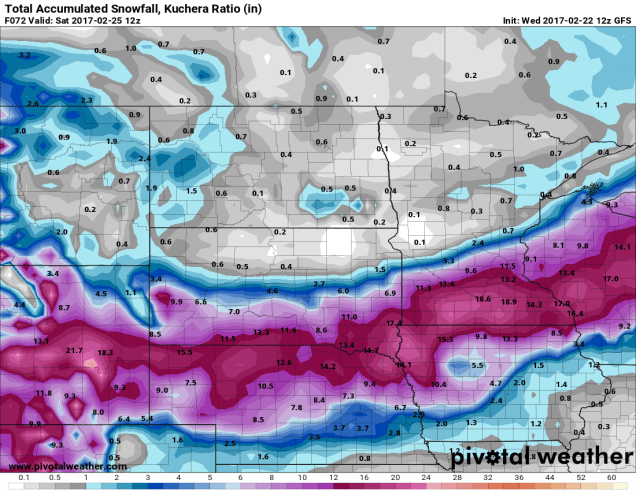
As the system heads eastward, snow will move into portions of the Mississippi Valley and the Upper Midwest on Friday. The heaviest snow looks to stay just south of the Twin Cities, but even there, moderate to heavy snow is likely. By the time the storm moves out on Saturday, a foot or more of snow is possible in a swath from the Central Plains into the Great Lakes.

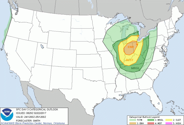
Snow isn’t the only threat from this system. As the storm moves eastward, record warmth will remain in place across the Midwest. With warm, moist air in place and a strong cold front approaching from the West, strong to severe thunderstorms are possible across portions of the Lower Great Lakes and Ohio Valley on Friday. Some of the stronger storms that form may contain damaging winds, hail, and possibly tornadoes.

day3otlk_0830
The Storm Prediction Center has already highlighted the Midwest as an area to watch for severe weather on Friday. Image provided by NOAA.

The system will continue to move eastward, bringing some rain to the East Coast on Saturday, which may cause problems for hockey fans in the Steel City. The next NHL Stadium Series game (Ed – Enough with the outdoor games already. It jumped the shark a long time ago), is scheduled for Saturday at 8pm between the Pittsburgh Penguins and Philadelphia Flyers. The daytime hours will likely be mild with rain, but the rain may change to snow late in the day as temperatures tumble. Either way, it won’t be a pleasant night for fans to be sitting in the stands at Heinz Field. Here at Storm HQ, we despise the Flyers, so we hope their fans not only have to sit through the weather, but watch their team get thumped too.

scott-wilson-jpg-size-custom-crop-819x650
That’s former UMass-Lowell RiverHawk (and StormHQ favorite) Scott Wilson hoisting the Stanley Cup last June. Image provided by Toronto Star.

Once it gets past Pittsburgh, that front will head eastward, bringing some rain to us here in New England. It probably won’t be a lot of rain, but temperatures will be in the 50s and possibly 60s ahead of the front on Saturday. Once the front comes through, Sunday will be windy and colder.

This Ride Probably Won’t Thrill You

“Get in, sit down, shut up, and hold on” – Toby Keith

Ladies and gentlemen, please make sure your safety belts are securely fastened, as this rollercoaster is ready to go. Yup, the weather will go through several changes over the next few days, giving us a little of everything – howling winds, bitterly cold wind chills, snow squalls, sleet, freezing rain, heavy rain, unseasonably mild temperatures. And that’s just before the weekend is over.

We’ll start with Thursday. A series of arctic cold fronts will cross the region. Some snow squalls may accompany the fronts, so you’ll need to be prepared for that if you’re out and about during the day. These are the winter equivalent of summer thunderstorms. They’re impossible to predict ahead of time, usually don’t last too long, but can have severe impacts if you get caught in one. Visibility can drop to near zero in an instant, a quick inch or two of snow could accumulate, and the next town over could see nothing at all.

winds
Very strong winds are likely Thursday night behind the cold front. Might be a good idea to bring some of those Christmas decorations inside for a few days. Image provided by National Weather Service – Taunton.

While the snow squalls can be a high-impact but localized event, the strong winds and bitterly cold temperatures will be felt region-wide. Northwest winds of 15-30 mph are likely, with gusts upwards of 50-60 mph possible, especially Thursday afternoon into Friday morning. High Wind Watches have been posted for parts of the region. If you have any loose objects outside, such as trash barrels, Christmas decorations, small children, etc, you may want to consider bringing them inside, so that they don’t blow away.

gfs_t2min_boston_9
GFS model forecast for low temperatures across the region Friday morning. Yes, those are in Fahrenheit, not Celsius. Image provided by WeatherBell.

These gusty winds will also usher some of the coldest air so far this winter into the region. Most days, the day starts off cool, warms up until mid-afternoon, then cools off again as the sun goes down. Thursday will not be one of those days. We’ll start the day with temperatures in the 30s, but temperatures will drop into the 20s by midday, then keep dropping. By Friday morning, most places will see temperatures in the single numbers, with some sub-zero readings possible. When you factor in the wind, the wind chill will be 15 to 25 below zero in many areas. Make sure you’re all bundled up if you have to head outside for any reason at all. Better yet, stay inside, it’s easier.

sfctwc-us_ne
Wind chills of 15 to 25 degrees below zero are expected Friday morning, Bundle up if you have to head outside for anything. Image provided by Pivotal Weather.

The good news is, the cold air will be short-lived. The bad news is, the transition from the arctic air will be rather messy. A storm system will head up the St. Lawrence Valley this weekend. Precipitation will develop ahead of this system before sunrise Saturday morning. That precipitation will start as snow, but as warmer air moves in aloft, it will start to change over. How quick that changeover occurs is the big question mark.

gfs_mslp_pcpn_frzn_neus_fh60-120
GFS model forecast for the progression of a storm system across the Northeast this weekend. Loop provided by Tropical Tidbits.

Cold air will likely remain entrenched at the surface, especially away from the coastline. With warm air moving in aloft, that means we’ll likely see a changeover to sleet and/or freezing rain across the interior Saturday afternoon. Along the coast, a quick change to rain is likely, as water temperatures remain in the 40s, which will help warm things up fairly quickly near the shoreline. Eventually, that warmer air will move in at the surface across the entire area, with a change to plain rain expected overnight. Before that changeover happens, we’ll probably see snowfall accumulations of 1-3″ south and east of I-95, including the Boston and Providence metropolitan areas. North and west of I-95, we’re looking at 2-5″ of snow, with the possibility of some sleet or ice accretion. Please keep this in mind if you have plans in this region Saturday afternoon/evening.

gfs_t2max_boston_17
Temperatures will be quite mild when you wake up Sunday morning, but more changes are coming. Image provided by WeatherBell.

OK, so it warms up Saturday night and everything changes to rain. End of story, right? Nope, the ride isn’t over yet. By Sunday morning, temperatures will be in the 40s to lower 50s north and west of Boston, with 50s and possibly even some 60s from Boston southward. So, Sunday will be a nice warm day, right? Nope. Temperatures will peak in the morning, then drop again throughout the day as the system drags a strong cold front across the region. In fact, if the rain is slow to depart, it could change back over to some snow or sleet before ending in the afternoon. It probably won’t accumulate, but with wet roads and sharply falling temperatures, we could see some black ice develop on many area roadways. Again, just one more thing to keep in mind in you are heading out and about late Sunday afternoon or evening.

Things start to calm down after that. Monday will be quite chilly again, with highs only in the 20s, and gusty winds keeping wind chills close to zero. Temperatures start to moderate next week, and a late-week system could bring in some rain. Right now, it’s not looking like a White Christmas, but things can still change. Beyond that? Well, the GFS model gave us a good laugh this afternoon.

gfs_mslp_pcpn_frzn_neus_51
The GFS model is having delusions this afternoon. Sure, it’s a possibility, but we’re not putting much stock in this forecast. It is fun to look at though. Image provided by Tropical Tidbits.

Winter Finally Is Arriving in the Plains

Just in time for Thanksgiving, it looks like all the ingredients are in place for Mother Nature to cook up a Plains Blizzard.

ncep_cfsr_noram_t2m_anom
To say that November has been warm across the nation would be a BIG understatement. Image provided by WeatherBell.


A storm system will move out of the Rockies and across the Plains states over the next few days. Ahead of the system, warm, moist air will be drawn northward from the Gulf of Mexico. High temperatures on Thursday will be in the 70s as far north as Chicago and Des Moines, with record high temperatures expected across much of the Mississippi Valley. The warmth won’t last too much longer though, as a strong cold front will be marching eastward across the Great Plains.

ndfd_record_hi_mc_2
Numerous record high temperatures are expected on Thursday across the Mississippi Valley. Image provided by WeatherBell.


Behind the front, much cooler air will settle southward from Canada. With plenty of moisture being drawn northward, it will fall as snow on the backside of the low from the Central Rockies and Central Plains northeastward into the Upper Midwest. Some of the snow could be heavy, especially in parts of South Dakota and Minnesota, where snowfall totals of 10-15 inches are expected by Saturday evening, with some heavier amounts possible. As you might expect, Winter Storm Watches have been posted from eastern Wyoming and northern Nebraska northeastward to Minnesota.

snku_acc-us_nc
Snowfall forecast through Saturday evening from the GFS model. Image provided by Pivotal Weather.


Snow isn’t the only hazard with this system. As it strengthens, it will create strong winds across much of the Plains states. Sustained winds of 20-30 mph with gusts to 50 mph or more are expected, especially from the Dakotas into Nebraska. The combination of high winds and snow may result in blizzard conditions at times. A blizzard watch has been issued for southwestern Minnesota, northeastern South Dakota, and extreme southeastern North Dakota.

warn
Yup, that’s a Blizzard Watch for parts of Minnesota and the Dakotas. Image provided by NOAA.

Once the system moves into southern Canada this weekend, some of the coldest air so far this season will settle into the region. While these temperatures aren’t that unusual for late November, they will be quite a change from the recent warmth that has enveloped the area. Low temperatures will likely drop into the teens and 20s across the region this weekend, with single digits possible. In some of the locations with fresh snowcover some sub-zero readings are possible. The cool air will be short-lived, as temperatures will likely warm back up to above normal readings by early next week. Current indications are that the unseasonably mild weather will persist for the most part well into December across the region.

As the system heads up into Canada, it will drag a strong cold front across our region on Sunday. Enjoy the mild air for the next few days, because things will change by late Sunday. In fact, on Monday, with temperatures expected to stay in the upper 30s and 40s at best, and some precipitation around thanks to an upper-level low pressure area, we could see some wet snowflakes falling. We’re not expecting any accumulation right now, because the ground is still much too warm, but we’re not going to rule out seeing snow showers at this point.


A Little Bit of Everything – October in the Northeast

October can be a time of change in the Northeast. While the first thing that comes to mind is the changing colors of the foliage across the region, the weather also changes, sometimes quite frequently. That’s what we’re going to be dealing with for the next few days.

rtma_t2m_neng
Current temperatures across the Northeast as of 1pm on October 19. Image provided by WeatherBell.


It’s an unseasonably warm afternoon across much of the Northeast, with temperatures generally in the 60s and 70s, with 80s from southern Connecticut into the Mid-Atlantic states. Dozens of record highs have been set over the past few days, and more are falling today. However, some changes are coming, and the warm weather will be a distant memory within the next 24-48 hours.

A cold front is moving across the region this afternoon, though you really couldn’t tell, as there’s only scattered cloud cover and little precipitation with the front. That front will stall out to the south of New England tonight. On Thursday, a wave of low pressure will start to approach from the west. This will spread rain and showers into the region. Some of the rain will be heavy, especially from New York into Pennsylvania late Thursday into Friday. With rainfall totals of 1-3 inches and locally up to 5 inches expected, some flooding is likely. Across New England, where a serious drought is ongoing, rainfall will be much lighter, with most locations likely receiving under half an inch of rain.

qpf_acc-us_ne
Expected rainfall through Friday evening across the Northeast. Image provided by Pivotal Weather.


As that wave of low pressure moves into Upstate New York on Friday, it will lift that cold front back across New England as a warm front. While Friday won’t be as warm as today, temperatures will still get into the 60s and lower 70s across much of New England. With dewpoints also in the 60s, it will be a rather muggy day for mid-October.

99l_tracks_latest
Computer model forecasts for the track of a tropical disturbance in the Bahamas. Image provided by Tropical Tidbits.


Meanwhile, there is a tropical disturbance brewing in the Bahamas right now. While conditions are favorable for development, we’re not looking at another monster like Matthew, it could become a tropical depression or subtropical storm over the next few days. The system will likely head northward, moving towards the Gulf of Maine as we head into the weekend. This will bring another round of heavy rainfall into Maine and Atlantic Canada, again missing most of Southern New England, where the rain is most needed.

qpf_048h-us_ne
Expected rainfall between Friday morning and Sunday morning across the Northeast. Image provided by Pivotal Weather.


Once the system moves into southeastern Canada, it is expected to stall out under an upper-level low pressure area and become a strong extratropical system. It will drag a cold front across the Northeast, bringing much colder air into the region. With strong low pressure nearby and much colder air filtering in, rain will change over to snow across portions of Upstate New York and Northern New England. While the snow will be confined mainly to the higher elevations, this is the first accumulating snow of the season across the area. Several inches may accumulate across parts of the Adirondacks and the Green Mountains.

gfs_6hr_snow_acc_neng_19
Expected snowfall through Sunday evening across the Northeast. Image provided by WeatherBell.


While there could be a few wet flakes mixed in with some of the rain across lower elevations of Central New England, accumulating snow is not expected.Sunday will be a chilly day, with highs only in the 40s and 50s across much of the Northeast. These readings are 10-20 degrees below normal. Of course, any mention of snow in October across the Northeast will make residents think back just a few years to the pre-Halloween snowstorm that dropped 1-2 feet of snow across parts of the region, setting numerous records. While this system won’t come anywhere close to that, it should make for some spectacular photos of snow-capped mountains and valleys filled with colorful foliage early next week.

20111029-20111030-1-75
Snowfall from the Halloween snowstorm of 2011. Image provided by NOAA.


Ready or Not, Here Comes Fall

“Summer’s going fast, nights growing colder”

Rush wrote that lyric for the song “Time Stand Still”, and it’s pretty obvious they were talking about September. No matter how you define it, summer is either just about over, or already is. Astronomical fall begins on September 22 at 10:21am EDT, but meteorological fall is defined as the period between September 1 through November 30. For some people, summer ends of Labor Day or when football starts up. No matter your definition, we’re at that time of year. While it can and does still feel like summer across parts of the nation, there are more and more signs that summer is winding down.

As the nights start to grow a little longer the farther north you go, the cooler air starts to build up a little more, especially as you head into Canada and Alaska. The cold fronts that drop down from Canada and into the Northern US start to pack a little more punch. One of those fronts is moving across portions of the Upper Midwest and the Great Plains today. The airmass moving into the Rockies and Northern Plains behind the front is sending temperatures as much as 15 to 25 degrees below normal this afternoon.

sfct_anom-conus
Temperatures are 15-25 degrees below normal in the Northern Rockies and Northern Plains today. Image provided by Pivotal Weather.

As that airmass settles in, low temperatures will drop into the 30s and 40s across the Northern Plains and Rockies tonight. Frost advisories and freeze warnings have been posted for western portions of North Dakota for Tuesday morning. By Wednesday morning, the coldest air will move over Minnesota, where low temperatures could drop into the upper 20s and 30s. Additional frost and freeze advisories will likely be issued for this region.

gfs_t2min_minnesota_9
A taste of things to come soon. GFS model forecast for low temperatures across Minnesota Wednesday morning. Image provided by WeatherBell.

Cold temperatures aren’t the only noteworthy item with this cold front. As the cold air surges into the Rockies, precipitation will accompany it. That precipitation will likely fall as snow in many areas, mainly at elevations above 5000 feet. Across some of the higher peaks, more than a foot of snow could accumulate over the next day or two. Winter Weather Advisories have been issued for portions of northern Wyoming as a result.

gfs_6hr_snow_acc_cw_9
GFS model forecast for snowfall through Wednesday morning. Image provided by WeatherBell.

Some snow is also possible across the higher elevations of the Sierra Nevada as the cooler air spreads into the West. While accumulations will be minor, this will likely be the first snowfall of the year for this region. Across the rest of the Golden State, temperatures will likely be 6 to 12 degrees below normal on Tuesday, with highs only in the 70s to lower 80s, a welcome change from the 90s and 100s they’ve had for most of the summer.

While this front will bring cooler air into our area later this week, one thing it won’t do unfortunately, is bring beneficial rainfall to the region. It will produce showers and some thunderstorms, and while a few of the storms may contain heavy downpours, they’ll be very localized. Across much of the region, rainfall totals will be generally under half an inch. This will do little to put a dent in the severe drought that much of the region is currently experiencing. Rainfall deficits of 5 to 10 inches below normal since the beginning of March are common across the region.We really need some rain, and there doesn’t look to be a lot of it on the horizon.

m6pdpt_northeast_aug16
Rainfall deficits across the Northeast from March 1 through August 31. Image provided by the Northeast Regional Climate Center.

While this early taste of fall moving into much of the Northern US this week is not uncommon for mid-September, it might not be repeated much this fall. Long-range forecasts are showing the likelihood of a warmer than normal fall across much of the United States.

Here Comes the Heat and Humidity

It’s been a warm and dry summer for most of the region, but the next few days will feature some very hot weather and unlike much of the summer, some extreme humidity.

CODNEXLAB-1km-LongIsland-rad-ani96-201608101830-100-100-raw
Some much-needed rain fell across Southern New England today. Loop provided by the College of DuPage.

A weak upper-level disturbance moved across the region this morning, bringing some much needed rainfall to the region. The cloud cover and rainfall has kept temperatures mainly in the 70s to lower 80s, but dewpoints have jumped into the upper 60s and 70s across the area. That moisture is going to remain in place for the next several days, but will be accompanied by some very hot weather.

Once some patchy fog burns off Thursday morning, we;ll have sunshine across the area. Since we’re going to start the day in the 70s, temperatures will quickly spike into the 80s and 90s by midday. South to southwest winds will keep temperatures in the 80s along the south coast, but elsewhere, highs will soar well into 90s. When you factor in the humidity, the heat index will be near or just over 100 degrees. As a result, a heat advisory has been issued for much of eastern Massachusetts from Noon until 7pm on Thursday. If your plans include outdoor activities, make sure you follow the usual precautions – drink plenty of liquids and stay out of the sun as much as possible.

Cpe1ERMVUAQcH_H
Heat index forecast for Thursday afternoon. Image provided by the National Weather Service.

Thursday isn’t the only hot day though, and in fact, it might not even be the hottest day this week. Friday will feature conditions similar to Thursday, but Saturday could be even hotter. Temperatures will soar well into the 90s once again, with heat indices topping 100 across much of the region.

sfcthi.us_ne
Heat index forecast for 5pm Saturday based on the NAM model. Image provided by Pivotal Weather.

While some showers and thunderstorms may pop up both Friday and Saturday afternoons to provide a little relief from the heat, it’s an approaching cold front that will bring an end to the heat wave. When that front arrives is still a big question mark. Some models want to bring the front through the region Saturday night, while others wait until later on Sunday. This obviously has a big impact on temperatures for Sunday across the region. What the models all agree on is that the front will stall out near the area at some point on Sunday, and then waves of low pressure will ride along the front. South of the front temperatures will still be in the 80s to lower 90s  with fairly high humidity, while north of the front temperatures will be in the 70s to lower 80s with lower humidity. The waves riding along the front will likely bring in some beneficial rainfall later Sunday into Monday, before the front finally pushes farther to the south. Neither day should be a washout, but we certainly need the rain. We’ll have more details on that later in the week as things become a little clearer.

The Heat is On, But is It a Heat Wave?

(Editor’s Note – This post was originally written for the blog hosted by the University of Massachusetts-Lowell Meteorology Program. This is the reason for the references to Lowell so often. For more information about the UML Weather Center, please visit their homepage at http://storm.uml.edu/)

A Heat Wave. Triple H weather.Bad Hair Days. The Dog Days of Summer. Whatever you like to call it, it’s something we have to deal with every year, though not nearly as much in New England as other parts of the country.

According the American Meteorological Society’s Glossary of Meteorology, the official definition of a heat wave is :”A period of abnormally and uncomfortably hot and usually humid weather.

The glossary adds further:

To be a heat wave such a period should last at least one day, but conventionally it lasts from several days to several weeks. In 1900, A. T. Burrows more rigidly defined a “hot wave” as a spell of three or more days on each of which the maximum shade temperature reaches or exceeds 90°F. More realistically, the comfort criteria for any one region are dependent upon the normal conditions of that region. In the eastern United States, heat waves generally build up with southerly winds on the western flank of an anticyclone centered over the southeastern states, the air being warmed by passage over a land surface heated by the sun.

How often do we have an actual heat wave here in New England? For Lowell, we average 2 heat waves per year. The most common time for one is between the middle of June and middle of August, but they have occurred as early as the middle of April and as late as late September. In the summer of 1955, we actually had 8 separate heat waves between the end of June and late August. The worst of the bunch was 9 day heat wave that started on June 30 and ended on August 7. On 3 of the 9 days (July 31, August 4, August 5), the high temperature was 100 degrees.

So far, we have not had a heat wave in Lowell in 2016. We had one in 2015, a 3 day stretch from September 7-9, but 2014 also did not feature a 3-day stretch of temperatures above 90.

While a 3-day stretch of 90-degree weather isn’t that uncommon around here, a string of 7 or more days in a row is. In fact, in the 125 years of climate data we have for Lowell, we’ve had a stretch of 7 consecutive days above 90 degrees just 20 times. The last time it happened was just 3 summers ago – July 14-20, 2013. Longer stretches are even rarer. We had a 10-day stretch of 90-degree temperatures from August 27 through September 5, 1953. This occurred just one year after a brutal 13-day stretch from July 11-23, 1952 that featured 4 days with highs above 100 degrees. The worst heat have in Lowell though was a 15-day stretch from August 1 through 15, 1988 which capped off one of the hottest summers in Lowell history.As if having 15-days of 90-degree weather isn’t tough enough, 11 of those days featured highs of 96 or higher, one (August 3) had a high of 100, and most of those days were accompanied by high humidity, with dewpoints well into the 60s and 70s.

While there have been many memorable heat waves in New England, there’s only one day that is known simply as “The Hot Day”. On August 2, 1975, a ridge of high pressure settled into the Northeast. August 1 was hot in its own right, reaching 102 for a high here in Lowell. Temperatures didn’t drop much that night, with the stifling airmass in place. The low temperature on August 2 here in Lowell was only 79, the warmest low temperature on record here. With temperatures already starting the day so warm, and plenty of sunshine, it didn’t take much to send temperatures to levels that had never been seen around here before. On Nantucket, the high hit 100 for the only time on record. Providence, Rhode Island reached 104, setting a new state record. In Massachusetts, a new state record of 107 was set in both Chester and New Bedford. Here in Lowell, our records show a high of 108 was recorded that day, but this seems suspect. High temperatures from other nearby spots that day included 105 in Reading, 103 in Pepperell, 103 in Haverhill, 101 in Lawrence, 100 in Nashua, and 99 in Dracut.

8021975DWM
Daily Weather Map for August 2, 1975. Image provided by NOAA.

Luckily, 100-degree heat isn’t common around here. On average, we hit 100 here in Lowell about once every 4 years.The last time it occurred was on July 22, 2011, when we reached 102. In both 1911 and 1952, we reached 100 degrees 5 separate times. 90-degree days occur and average of 14 times per year.So far in 2016, we’ve had 4 days with highs of 90 or higher.1932 is the only year on record in Lowell where the high temperature failed to hit 90 degrees.On the other hand, 1955 saw an incredible 46 days with highs of 90 or higher, just ahead of the 45 such occurrences in 1983.

Whether we hit 90 or not today is still to be determined (the temperature in Lowell was 87 at the time of this being written), but it certainly seems like there are more 90-degree days in our immediate future. The GFS model is showing the possibility of high temperatures in the lower to perhaps middle 90s Sunday and Monday ahead of a cold front, then the possibility of more heat late in the week.

gfs_t2max_boston_11
High temperature forecast for Monday July 18 based on the GFS model. Image provided by WeatherBell.


It’s Going to get Hot, Hot, Hot! (Not Around Here Though)

A ridge of high pressure over the Plains states will slowly shift westward over the next few days, with intense heat across the Plains heading for the Desert Southwest.

High temperatures soared well into the 90s across the Southern Plains on Wednesday, but when the humidity was factored in, the heat index exceeded 100-110 degrees in parts of the nation’s midsection.  Only a few showers and thunderstorms provided scattered relief to the region. On Thursday, with similar conditions expected across much of the Southern Plains and parts of the Mississippi Valley, heat advisories have been posted for much of the region. High temperatures will be well into the 90s once again with some triple digit readings expected. When the humidity is factored in, heat index values will be in the 100-115 degree range across the region.

gfs_hindex_tx_6
Forecast for heat index values for Thursday afternoon. Image provided by WeatherBell

While the nation’s midsection has been enduring the heat, a trough of low pressure has been keeping the West cool for the past few days. Temperatures have been as much as 10 to 20 degrees below normal, especially across the Pacific Northwest. Across the higher elevations of the Cascades, several inches of snow has been reported.

500hv.conus
Forecast for 500mb heights for Sunday June 19. Image provided by Pivotal Weather.

While the Northwest will remain cool into the weekend, much warmer weather will move into the Southwest as a ridge of high pressure builds westward. By Saturday, temperatures will be 10-20 degrees above normal in the Desert Southwest. For a place that is “normally” hot, anomalies that big can break records. In Phoenix, high temperatures could approach 120 degrees on Sunday. The record high for that day is 115, set in 1968.

gfs_t2max_lower48_14
High temperature forecast from the GFS model for Saturday June 18. Image provided by WeatherBell.
gfs_t2max_lower48_18
High temperature forecast from the GFS model for Sunday June 19. Image provided by WeatherBell.

Excessive heat watches have been posted for much of the Southwest from Saturday through Tuesday. The hottest days look to be Sunday and Monday, when high temperatures will likely exceed 110 degrees in Las Vegas, and could approach 120 degrees in Phoenix and Yuma. In Death Valley, California, high temperatures on Sunday and Monday could approach 125 degrees.

Even at night, there will be little relief, as low temperatures may only drop into the 80s to lower 90s across the area. In Death Valley, temperatures may only drop below 100 degrees for a couple of hours.

While temperatures may drop a few degrees later in the week, the ridge of high pressure is expected to remain in place across the Southwest right through the end of the month, keep temperatures above to well above normal.

Here in New England, high pressure will keep us dry and seasonably warm right into the start of next week. Temperatures could get well into the 80s Monday and Tuesday, but no sustained heat is expected for at least the next 10 days.

Here Comes the Heat (Except for You New England)

A large ridge of high pressure will shift from the West Coast into the Nation’s midsection over the next few days, bringing with it some of the hottest weather so far this year to the Plains states.

ncep_cfsv2_120_t2anom_usa
Temperature anomalies for the past 30 days across the nation. Image provided by WeatherBell.

A persistent ridge of high pressure has been anchored across the West for the past few weeks, keeping temperatures well above normal for much of May and early June. Numerous records were set across the region, even in normally hot locations like the Desert Southwest, where temperatures exceeded 110 degrees several times. In Death Valley, California, which is frequently the nation’s hotspot, the first 8 days of June have averaged 10.6 degrees above normal, with high temperatures exceeding 115 degrees each day.

While the West has been baking, temperatures across the Plains states have been 1 to 3 degrees below normal for the past month. That is about to change as the ridge slides eastward. By the end of the week and the weekend, the ridge will be centered across the Plains and doesn’t look to move that much right through next week.

500hv.conus (1)
Map showing heights at the 500mb level across the United states on Sunday June 12. Image provided by Pivotal Weather.

500hv.conus (2)

With the ridge of high pressure in place, temperatures will soar well into the 90s across the Plains states and adjacent portions of the Mississippi Valley for much of the remainder of the week, with some triple-digit heat possible across parts of the Dakotas, especially Friday and Saturday.

Some relief will settle into the Northern Plains in the form of a cold front early next week, but the heat will continue from the Southern Plains and Texas eastward into the Southeast. Across these areas, humidity levels will be higher, with dewpoints rising into the 60s and 70s. The result will be heat index values well over 100 degrees across parts of these areas.

gfs_t2max_mw_14
High temperature forecast based off of the GFS model for Saturday June 11. Image provided by WeatherBell

The ridge will also act to suppress thunderstorm activity across the Plains states for much of the remainder of the week. Cluster of thunderstorms may develop across the Northern Rockies and ride over the Ridge and into the Great Lakes and eventually the Northeast later in the week. One of these clusters could produce some severe weather across the Eastern Great Lakes and Mid-Atlantic states on Saturday.

While the heat settles in across the Plains temperatures will remain cool across the Northeast. An upper-level low pressure system will only slowly move eastward across southern Canada over the next few days, moving into the Gulf of Maine by early next week. While temperatures surge into the 90s and lower 100s across the Dakotas on Friday, temperatures will only be in the 60s to lower 70s across the Northeast, with parts of Northern New England staying in the 50s. A few showers may pop up during the afternoon, and across some of the higher peaks of the region, some wet snowflakes could mix in with the rain.

There are signs that things could change in New England, but not until the end of next week. Some of the forecast models are indicating the possibility that the upper-level low finally moves out, allowing the heat to finally spread eastward. The latter half of June could feature much warmer conditions if this does come to pass.

gefs_t2ma_5d_noram_63
Temperature anomalies forecast by the GFS Ensemble for the period June 19 through June 24. Image provided by WeatherBell.