“March comes in like a lion and goes out like a lamb”
March isn’t going to come in like a lion this year, but a cheetah might be more accurate, since we’ve got a fast-moving storm system coming in for the start of the month.
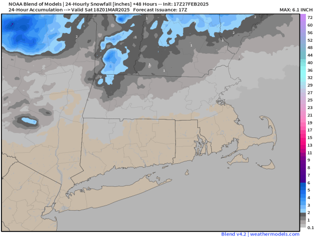
A little bit of snow is expected across parts of the region Friday night. Image provided by Weathermodels.com.
High pressure will build in for tonight and much of Friday with drier weather. With temperatures expected to drop below freezing tonight, there could be some icy spots developing on any untreated surfaces, especially ones that don’t see much sunlight during the day. Clouds stream back in late Friday ahead of a fast-moving storm system. We’ll see some light snow developing Friday night, but as milder air moves in, it should change to rain in most places as we get into Saturday morning before it winds down. Accumulations will be minor, if it accumulates at all, with an inch or less for most of us, maybe up to 2 inches in parts of central New Hampshire. Saturday could be another day, with a few breaks of sun developing, but a cold front will move through in the afternoon with some additional rain showers. We’ll clear out behind that front Saturday night, then high pressure builds in with sunshine and much colder weather for Sunday and Monday.
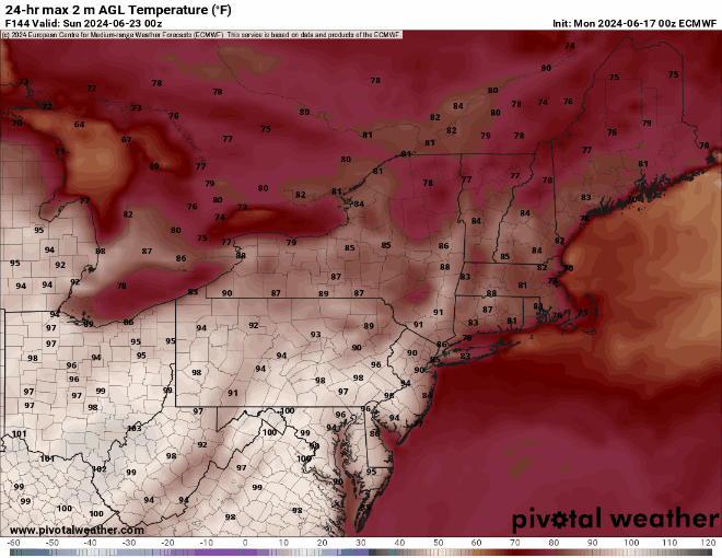
Temperatures at midday Sunday will be 20-30 degrees colder than midday Saturday. Image provided by WeatherBell.
Thursday night: Mostly cloudy with any lingering showers ending in evening, skies start to clear out after midnight. Low 29-36.
Friday: Partly to mostly sunny, clouds start to filter in late in the day, breezy. High 39-46.
Friday night: Mostly cloudy, light snow developing north of the Mass Pike before midnight, rain showers south of the Pike. Snow changes to rain from south to north before daybreak. Low 25-32 during the evening, temperatures rise after midnight.
Saturday: Showers taper off in the morning, some sunny breaks develop, then another round of showers is expected in the afternoon, breezy. High 47-54.
Saturday night: Gradual clearing. Low 13-20.
Sunday: Plenty of sunshine, breezy, and colder. High 24-31.
The final days of January and first few of February are going to feature some typical winter weather with chilly temperatures and a few chances at some light snow.
We start the week out with a sunny, breezy, and chilly day with temperatures close to where they should be in late January. Things start to change on Tuesday as a cold front moves through in the morning. This front may be accompanied by some snow showers or squalls, which could drop a quick half an inch to an inch in spots, possibly as early as the morning commute, so keep this in mind for your drive to work or school.
A line of snow showers or squalls will likely cross the region Tuesday morning. Loop provided by WeatherBell.
An Alberta Clipper will quickly follow on Wednesday. There is still some uncertainty with the exact track this system will take, which has an impact on the forecast. Some models bring the system across Northern New England, which would mean some rain or snow showers for most of us. Some bring it right across the region, with some light snow mainly north of the Mass Pike, and rain or snow showers to the south, and some bring it south of New England, with light snow for everyone. For now, we’re going to play the middle ground, with some light snow or snow showers for much of the region, possibly mixed with rain across parts of Rhode Island and southeastern Massachusetts. An inch or two of snow could accumulate, in most spots from this storm. Once this system moves by, we get another arctic blast for Thursday with very cold temperatures and gusty winds, but it only lasts for one day as temperatures quickly moderate on Friday.
Most spots will only see an inch or two of snow from Wednesday’s Clipper system. Image provided by Weathermodels.com.
The weekend is a bit of a question mark at this point. Most of the models all have a system moving in at some point later Friday into Saturday, though at least one model now keeps the storm south of New England. Some have milder air moving in ahead of it, with some rain, changing to snow as the system moves by, some have just occasional rain or snow showers through the weekend, and some have nothing at all. It’s far too early to tell which solution (if any of these) will be right, so we’ll just keep monitoring it, and will hopefully have a bit more clarity when we get to our Weekend Outlook on Thursday. Right now, it looks like high pressure will build in for Sunday with drier weather.
The models all have differing ideas about a potential storm for Friday night. Images provided by Pivotal Weather.
Sunday is also Groundhog Day. According to tradition, if the groundhog emerges from its burrow and sees its shadow, and will go back inside and winter will last for 6 more weeks. If it doesn’t see its shadow, spring will arrive early. The most famous celebration of this day takes place in Punxsutawney, PA, where Punxsutawney Phil is brought out every year. He has only seen his shadow 20 times in the 138 years this has been recorded.
Image provided by Someecards
Monday: Plenty of sunshine with a few afternoon clouds, breezy. High 32-39.
Monday night: Becoming partly to mostly cloudy, breezy. Low 25-32.
Tuesday: Intervals of clouds and sun, chance for some snow showers or squalls during the morning, windy, especially through early afternoon. High 31-38 in the morning, temperatures start dropping in the afternoon.
Tuesday night: Mostly cloudy, light snow or snow showers develop before daybreak. Low 12-19, though temperatures may hold steady or rise a little after midnight.
Wednesday: Mostly cloudy with some light snow or snow showers likely, possibly mixed with rain across parts of Rhode Island and southeastern Massachusetts. High 32-39.
Wednesday night: Clearing, breezy. Low 10-17.
Thursday: Sunshine and a few clouds, breezy, colder. High 23-30.
Thursday night: Partly cloudy. Low 12-19, but temperatures may start rising after midnight.
Friday: Intervals of clouds and sun, breezy, rain or snow possible late in the day. High 33-40.
Saturday: Partly to mostly cloudy with a chance of rain or snow. High 30-37.
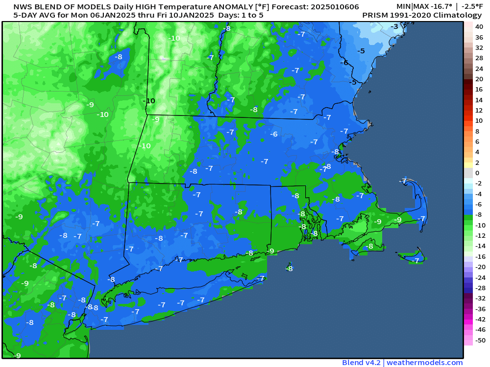
Some rather cold air is on the way, and it will hang around for a few days.
Temperatures will be well below normal over the next several days. Image provided by Weathermodels.com
The storm that brought us some snow last night will pull away today with any lingering snow ending early this morning and skies rapidly clearing by afternoon. As the colder air floods in on gusty northwest winds, temperatures may only get back up into the lower to middle 20s in the afternoon, with wind chills in the teens and single numbers. Winds die down during the evening, and with clear skies and fresh snowcover, it’s going to be a rather cold night, with lows dropping into the single numbers, possibly even below zero in a few of the colder spots. High pressure builds in with cold temperatures for Tuesday into Thursday, with many places not reaching 20 degrees on Tuesday or Wednesday. Wind chills will be in the single digits during the day and below zero at night. We are going to have a low pressure area passing well south of the region Tuesday night into early Wednesday, sending some clouds in, but we should remain dry, except for possibly a few flurries across the Outer Cape and Islands. Thursday looks dry and cold as well, but temperatures may be a few degrees milder than the previous couple of days.
Subzero wind chills are expected when you head out the door Wednesday morning. Image provided by WeatherBell.
We’re watching another system that will pass south of the region Thursday night and early Friday. Right now, this one looks like it will stay a little too far offshore to have much impact, but again, there could be some snow in parts of Cape Cod and possibly southeastern Massachusetts. It’s too early to tell how close it will get, so we’ll keep an eye on it, and should have a much better idea when we publish our Weekend Outlook on Thursday. Temperatures will moderate a bit more for Friday and Saturday, then a cold front may produce a few snow showers on Sunday.
Some snow is possible across southeastern New England Thursday night. Images provided by Pivotal Weather.
Monday: Any lingering snow ends early, then becoming mostly sunny with a few afternoon clouds, breezy, especially during the morning and early afternoon with some blowing snow. High 19-26. (Wind chill 5-15).
Monday night: Partly cloudy during the evening, then becoming clear overnight. Low 1-8, a little milder across the Cape and Islands. (Wind chill -5 to +5)
Tuesday: Morning sunshine, then increasing afternoon clouds. High 15-22. (Wind chill 5-15)
Tuesday night: Evening clouds, possibly a few flurries across the Outer Cape and Islands, then clearing. Low -2 to +5, a little milder across the Cape and Islands. (Wind chill -10 to 0)
Wednesday: Mostly sunny and cold. High 14-21. (Wind chill 5-15)
Wednesday night: Partly cloudy. Low 1-8, a little milder across the Cape and Islands. (Wind chill -5 to +5)
Thursday: Partly sunny, not as cold. High 24-31. (Wind chill 15-25)
Thursday night: Partly cloudy, slight chance for some light snow or snow showers across southeastern Massachusetts and Cape Cod. Low 8-15, a little milder across the Cape and Islands.
Friday: A mix of sun and clouds. High 26-33.
Saturday: Sunshine and some late-day clouds. High 27-34.
Sunday: More clouds than sun, chance for a few snow showers. High 32-39.
Some chilly weather, even by January standards, is expected for much of the week, but things could get complicated next weekend.
Low pressure will pass south of New England today, producing a snowstorm in Washington, DC. Loop provided by Tropical Tidbits.
A low pressure system will pass south of New England today. This is the same storm that brough blizzard conditions to Kansas City over the weekend, and a decent-sized snowstorm to Washington, DC today. Around here, it’ll just bring in clouds, and maybe a few flurries to the Cape and Islands. That storm will combine with another one over Newfoundland and remain in place for much of the week, resulting in generally dry but breezy and chilly conditions through Friday. Some weak upper-level disturbances may move through at times, generating a few snow showers here and there, but they’ll be on the light side.
Temperatures will be 5-10 degrees below normal this week. Image provided by Weathermodels.com
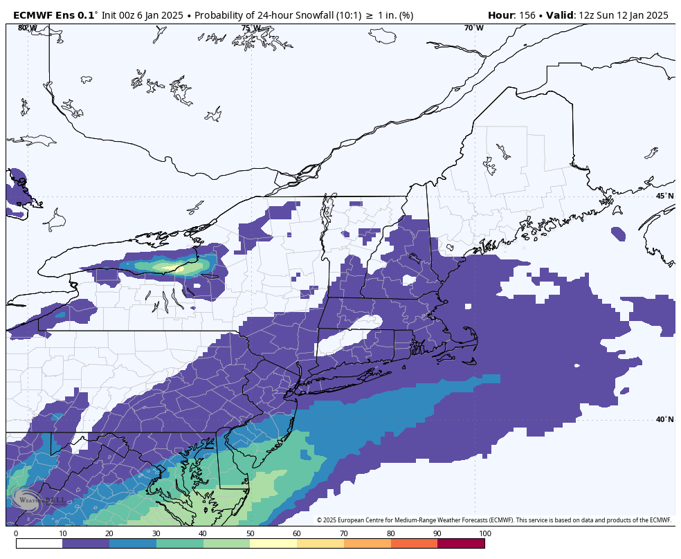
By the end of the week, a storm system will begin taking shape that could produce wintry weather from Texas into the Tennessee Valley at the end of the week. What it does next weekend is still a big question mark, and dependent on a few upper-level features that are still out over the Pacific Ocean, which makes things highly uncertain at this point. You may have seem some of the usual characters on social media (a.k.a. Facebook Forecasters) posting maps showing a massive blizzard impacting New England. Yes, some of the models have shown this, and yes it’s possible, but the odds of it happening at this point seem fairly low to us. There are two other scenarios shown on the models that seem more likely, at least for now. One scenario is that the system moves off the Carolina or Mid-Atlantic coastline and stays well to the south, with no impacts up here at all, similar to today’s system. A second scenario is that the storm does develop, and moves off the Mid-Atlantic coast, but stays just far enough offshore that we are only on the fringe of the storm, with some light snow for part of the region. For now, we’re going to lean towards these latter scenarios, while keeping a close eye on the development of the system, just in case, the initial scenario becomes more likely (though we don’t expect at that to be the coast). We’ll obviously have much more clarity when we publish our Weekend Outlook Thursday afternoon.
The ensembles only indicate a slight chance for a little snow next weekend. Image provided by WeatherBell.
Monday: More clouds than sun, slight chance for a flurry across Martha’s Vineyard and Nantucket, skies may start to clear out late in the day. High 23-30.
Monday night: Clouds hang around across the Outer Cape, clearing elsewhere, becoming breezy. Low 11-18.
Tuesday: A mix of sun and clouds, a stray snow shower is possible, breezy. High 22-29.
Tuesday night: Clear to partly cloudy, breezy. Low 12-19.
Wednesday: Sunshine and some afternoon clouds, maybe a snow shower, windy. High 21-28.
Thursday: Partly sunny, slight chance for a flurry, breezy. High 24-31.
Friday: Mostly sunny, not as chilly. High 31-38.
Saturday: Intervals of clouds and sun, slight chance for some light snow at night, favoring areas south of Boston. High 30-37.
Sunday: Intervals of clouds and sun with a slight chance for some light snow, mainly south of Boston. High 30-37.
As we head into the final week before Christmas, Hanukkah, Kwanzaa, or whatever else you celebrate, we’ve got some active weather ahead. We also will officially enter astronomical winter this week, with the Winter Solstice at 4:20am on Saturday (Meteorological Winter started on December 1).
Tuesday looks like a mild day ahead of a cold front. Image provided by Weathermodels.com.
A weak low pressure system will pass south of the region today, but with plenty of dry air in place, most of the precipitation associated with that system will dry up before it gets here, with only a few flurries or freezing drizzle possible this morning. However, another system quickly follows that one. As it heads across southern Canada, it will drag a warm front across the region this evening, with some rain expected ahead of the front tonight into Tuesday morning. Temperatures will rise behind the warm front tonight, setting up a mild day on Tuesday, though a cold front will move through in the afternoon. We’ll clear out behind that front later Tuesday, but clouds quickly return on Wednesday as yet another system heads our way. This one will bring in some more rain Wednesday night into early Thursday, however, it may be cold enough for some snow across parts of southern New Hampshire and the Merrimack Valley at the start. Everything winds down Thursday morning as the system pulls away, with clearing Thursday afternoon.
Rain may start as a little snow Wednesday night, mainly north and west of I-495. Images provided by Pivotal Weather.
Another weak system moves through on Friday with a few snow showers possible. For the weekend, we’re watching high pressure build in across southern Canada, and low pressure develop off the Mid-Atlantic states. Right now, it looks like the high will be the dominant force around here, with dry and very chilly weather, but that’s far from a lock at this point, so we’ll keep a close watch on it, in case things start to change.
At least one model shows the potential for a brutally cold day on Sunday. Image provided by WeatherBell.
Monday: Morning clouds with a flurry or some freezing drizzle possible, some afternoon sunny breaks develop. High 37-44.
Monday night: Partly to mostly cloudy with some light rain developing, becoming breezy after midnight. Low 34-41 during the evening, temperatures rise overnight.
Tuesday: Rain ends early, then a mix of sun and clouds with diminishing winds for the afternoon. High 50-57.
Tuesday night: Clear to partly cloudy. Low 30-37.
Wednesday: Becoming mostly cloudy, rain develops at night, possibly starting as snow north and west of I-495. High 42-49.
Thursday: Rain or snow ends early, skies clear out in the afternoon, breezy. High 39-46.
Friday: More clouds than sun with a few snow showers possible. High 29-36, a little warmer across southeastern Massachusetts and Cape Cod.
Saturday: A mix of sun and clouds, chance for some snow showers, mainly across Cape Cod. High 27-34, a little warmer across southeastern Massachusetts and Cape Cod.
Sunday: Partly to mostly sunny, quite chilly. High 17-24, a little milder across southeastern Massachusetts and Cape Cod.
Temperatures will be riding a rollercoaster this week, but we’re still not expecting much rain.
It’s looking rather chilly across the region tonight. Image provided by WeatherBell.
The week starts off with a rather chilly day as high pressure settles in. Despite sunshine, temperatures will only get into the 50s for most spots, and some may not even get that warm. As the high moves overhead tonight, we’ll have clear skies and light winds – a perfect recipe for radiational cooling. Some high clouds may start to move in overnight, which would slow the temperature fall. Temperatures should drop below freezing for much of the region, except possibly the urban areas and some spots across Cape Cod. If you’ve still got a few plants outside, it’s time to bring them in. The high slides off to the east on Tuesday, allowing temperatures to start to moderate a bit. Clouds move in late in the day ahead of a warm front. That warm front may bring in a few showers Tuesday night, but they shouldn’t be that widespread or heavy. Behind it, much milder weather returns for Wednesday and Thursday. Despite some clouds, temperatures will likely top 70 again in many locations on Halloween, and possibly even 80, which will make for some rather nice trick-or-treating weather Thursday evening, and possibly set a few records as well. Another cold front will move in early Friday, again with only a few showers accompanying it. Temperatures look like they’ll be quite mild in the morning, but cooler air moves in behind it during the afternoon. If the front comes in even later than we’re currently thinking, then we could see many places get well into the 70s again on Friday. High pressure returns for next weekend with much cooler air once again.
The models don’t agree on the timing of Friday’s cold front, which has a significant impact on the temperature forecast. Images provided by Pivotal Weather.
Don’t forget – Daylight Saving Time ends Sunday at 2am, when the clocks go back one hour. So, the good news is that you get an extra hour of sleep Saturday night. The bad news? Sunset next Sunday is at 4:34pm.
Clocks go back one hour at 2am on Sunday. Image provided by the Associated Press.
Monday: Sunshine and a few clouds. High 48-55.
Monday night: Clear through the evening, some high clouds may start to drift in after midnight. Low 27-34, a little milder across the Outer Cape and in urban areas.
Tuesday: Increasing and thickening clouds. High 52-59.
Tuesday night: Mostly cloudy, chance for some widely scattered showers. Low 46-53 during the evening, temperatures may start to rise a bit after midnight.
Wednesday: Becoming partly sunny, breezy, and warmer. High 67-74, a little cooler across Cape Cod.
Thursday: Partly sunny, breezy, and very warm. High 72-79, a little cooler across Cape Cod.
Friday: Some morning showers, some clearing in the afternoon, breezy. High 63-70.
Saturday: Mostly sunny, cooler. High 49-56.
Sunday: Sunny in the morning, clouds start to move back in during the afternoon. High 53-60.
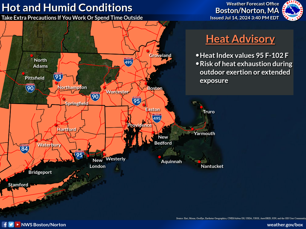
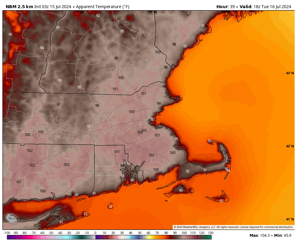
Hot and humid weather continues for the first half of the week, but some relief is on the way.
Heat Advisories are in effect for a large portion of the region into Wednesday. Images provided by the National Weather Service in Norton.
A Bermuda High remains anchored offshore, with southwest winds around the high continuing to pump hot and humid weather into the region into Wednesday. Daytime highs will likely top 90 away from the South Coast, and when the humidity is factored in, it will feel like it is near or over 100 degrees during the hottest part of the afternoon. Heat Advisories have been posted for the region as a result. Try to stay indoors if you can, and take precautions if you will be outside, including wearing sunscreen, seeking shade as much as possible, and drinking plenty of liquids. A few showers and thunderstorms are possible this afternoon and again Tuesday afternoon as a pair of weak disturbances cross the region, but these will likely not be that widespread. If you do get caught under one, heavy downpours and gusty winds are the biggest threats.
The heat index will be near or over 100 across much of the region Tuesday afternoon. Image provided by WeatherBell.
A cold front will move in on Wednesday, with more widespread showers and thunderstorms along and ahead of it Wednesday afternoon and night. Some of the storms could be quite strong, with strong winds and heavy downpours the main threats once again. Once the front moves through at night, much drier air settles in for the end of the week and the weekend. Instead of dewpoints in the upper 60s and 70s, we’ll see dewpoints in the 50s, maybe even upper 40s, and air temperatures will be in the 80s during the day, and 60s possibly upper 50s at night, so you’ll be able to give the air conditioner a break and open the windows. We may start to warm up again by the end of the weekend as high pressure slides offshore.
Dewpoints will drop into the upper 40s and 50s as much drier air settles in on Thursday. Image provided by Weathermodels.com
Monday: Some patchy fog early, otherwise sunshine and some afternoon clouds, chance for an afternoon shower or thunderstorm. High 89-96, cooler along the South Coast and Cape Cod.
Monday night: Any showers or storms end in the evening, otherwise partly cloudy. Low 68-75.
Tuesday: Partly to mostly sunny, a late-day shower or thunderstorm possible. High 90-97, cooler along the South Coast and Cape Cod.
Tuesday night: Partly cloudy, any showers or storms end in the evening. Low 69-76.
Wednesday: Partly sunny, showers and thunderstorms likely late in the day and into the night. High 89-96, cooler along the South Coast and Cape Cod.
Thursday: A mix of sun and clouds, not as humid. High 80-87.
Friday: Mostly sunny. High 79-86, cooler along the coast.
The heat will relent for the weekend, but the humidity will take a bit longer.
Friday afternoon temperatures will be 15-25 cooler than this afternoon across the region. Image provided by Pivotal Weather.
Today will be the last hot and humid day for a bit across the region, with some strong to severe thunderstorms bringing an end to the heat this afternoon and evening. The main threats with these storms are heavy downpours and gusty winds. Tonight will remain warm, but a backdoor cold front moves through on Friday, ushing much cooler air in, as winds shift into the northeast, and blow in over the still relatively cool Atlantic. Highs on Friday will only be in the 70s and 80s, warmest near the South Coast, where we’ll still get warm in the morning before the front moves through. Dewpoints will drop a bit, but will likely remain in the 60s, so it’ll be on the humid side still. Some showers are likely ahead of the front as well. The front stalls out near or just south of the region on Saturday, resulting in a rather comfortable day, but with a decent amount of clouds. On Sunday, that front will try to lift northward as a warm front once again, bringing the very warm and humid air back in. However, a disturbance moving in from the west will likely help to produce some showers and thunderstorms during the afternoon and evening. A cold front moves through on Monday, with warm, humid conditions ahead of it in the morning, along with more showers and thunderstorms, then cooler and drier air starts to move in by late in the day behind the front.
Dewpoints remain fairly high through the weekend, then finally start to drop late Monday. Loop provided by WeatherBell.
Thursday night: Showers and thunderstorms ending shortly after sunset, remaining partly to mostly cloudy overnight. Low 65-72.
Friday: Partly sunny with some showers likely. High 82-89 in the morning, turning cooler in the afternoon.
Friday night: Mostly cloudy, a few additional showers, mainly during the evening. Low 61-68.
Saturday: More clouds than sun, a few showers possible. High 77-84, a little cooler along the coast, especially the North Shore and NH Seacoast.
Saturday night: Mostly cloudy, chance for a shower. Low 60-67.
Sunday: Intervals of clouds and sun, breezy, showers and thunderstorms possible late in the day. High 83-90, cooler across the South Coast and Cape Cod.
Sunday night: Partly to mostly cloudy, showers taper off during the evening. Low 65-72.
Monday: A mix of sun and clouds, some showers around during the morning. High 79-86, a little cooler across Cape Cod.
Ready or not, the first heat wave of the summer is on the way later this week.
A warm front will cross the region today with just some clouds accompanying it, but little to no precipitation. Behind it, south to southwest winds will usher warmer and more humid air in, and it will remain in place for a good chunk of the week. High pressure building in both at the surface and aloft will result in partly to mostly sunny skies with hot and humid conditions from Tuesday into at least Thursday. The south winds will keep the South Coast and Cape Cod cooler, only in the 80s or even upper 70s, but inland temperatures will get well into the 90s, but when you factor in the humidity, it will feel like 95-105 degrees during the hottest part of the day each afternoon. Air temperatures could approach 100 both Wednesday and Thursday afternoon, especially from MetroWest into the Merrimack Valley, with some records possible. Excessive Heat Watches and Heat Advisories are already in effect for parts of the region from Tuesday afternoon into Friday evening. A few showers and thunderstorms may pop up each afternoon, especially Thursday, but they will be widely scattered, and only provide some relief in a few spots.
Thursday is looking like the hottest day in quite some time across the region. Image provided by WeatherBell.
By the end of the week, a cold will start to drop down from the north, bringing more widespread showers and thunderstorms along with cooler weather, but when it moves through is still a question mark. Some models bring it down on Friday, have it lift back northward later Saturday, others have it move through on Friday, then not come back until early in the following week. This will obviously have a big impact on the temperature forecast, especially for the weekend. Some showers will likely accompany this front as waves of low pressure ride along it, but timing them is a fool’s errand at this point, because we’re not even sure yet when the front will move through.
Not all of the models have cooler air move in for Saturday. Images provided by Pivotal Weather.
Monday: A mix of sun and clouds, breezy during the afternoon. High 78-85, a little cooler near the South Coast.
Monday night: Clear to partly cloudy. Low 61-68.
Tuesday: Partly to mostly sunny. High 90-97, except 82-89 near the South Coast and 74-81 across the Cape and Islands.
Tuesday night: Clear to partly cloudy. Low 64-71.
Wednesday: Sunshine and a few clouds. High 93-100, except 85-92 near the South Coast and 77-84 across the Cape and Islands.
Thursday: Partly sunny. High 95-102, except 87-94 near the South Coast and 79-86 across the Cape and Islands.
Friday: Intervals of clouds and sun with some showers and thunderstorms possible. High 90-97, except 82-89 near the coast.
Saturday: Partly sunny, chance for an afternoon shower or thunderstorm. High 84-91, cooler near the coast.
Sunday: Intervals of clouds and sun, showers and thunderstorms possible. High 80-87, cooler near the coast.
Milder weather is on the way for the upcoming weekend.
Temperatures could be very mild around here on Saturday. Image provided by WeatherBell,
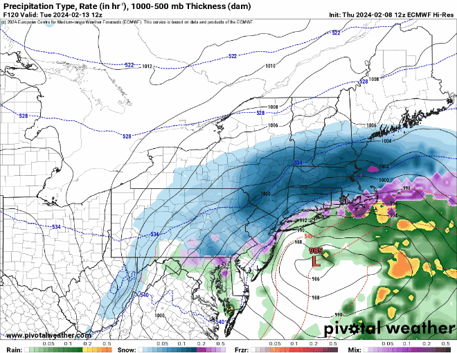
We finally got some sunshine over the past several days, but unfortunately, there are more clouds on the way. They’ll spread across the region tonight as low pressure moving into the Great Lakes sends a warm front our way. There could be a stray rain or snow shower accompanying the warm front, but they’ll be few and far between. We’ll see some sunshine return on Friday along with milder temperatures, with highs getting well into the 40s. Clouds come back Friday night and much of Saturday, but south to southwest winds will result in a very mild day for Saturday. High temperatures should get well into the 50s away from the coastline, with some places possibly topping 60. Along the coast, especially south-facing shorelines, we’ll have a seabreeze (yes, in February), keeping temperatures in the 40s, which is still well above normal. A cold front moves through late in the day, bringing some showers with it. High pressure builds in behind the front for Sunday, but the air isn’t that much colder. Most of us will still be in the 40s, with a few spots possibly reaching 50 again. Clouds stream back in Sunday night and Monday as low pressure heads toward the Mid-Atlantic states. The hype train left the station yesterday for this storm, as several computer models showed the potential for a sizeable snowstorm Monday night and Tuesday. Well, the models all continue to shift, and range from a moderate snowstorm, to a snow to rain situation, to a complete miss to the south. It’s still several days away, so things will continue to change, and if it does become a threat, we’ll go into more detail on our Weekly Outlook early Monday morning. For now, don’t believe the hype and don’t get too worked up about it.
Snow? Rain? Both? None? The models don’t agree on the storm threat for Tuesday right now. Images provided by Pivotal Weather.
Thursday night: Clear skies through the evening, clouds move in overnight, slight chance for a sprinkle or flurry. Low 25-32.
Friday: Morning clouds, becoming partly sunny in the afternoon, a little breezy at times. High 42-49.
Friday night: Becoming partly to mostly cloudy. Low 32-39.
Saturday: Partly to mostly cloudy with some showers likely during the afternoon and evening. High 52-59, cooler along south-facing shorelines.
Saturday night: Any lingering showers end during the evening, some clearing possible late at night. Low 35-42.
Sunday: A mix of sun and clouds, breezy. High 44-51.
Sunday night: Partly cloudy. Low 27-34.
Monday: Becoming mostly cloudy, chance for some snow or rain towards evening. High 40-47.