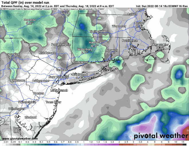
There’s a chance for some beneficial rainfall this week to help put a dent in the drought. Unfortunately, that chance is a lot smaller than it looked a few days ago.
High pressure will slide offshore today, allowing for another in a string of rather nice days across the region with mild temperatures and low humidity. A low pressure system will be starting to take shape off the Mid-Atlantic coast while and upper-level low also sets up residence across the Northeast. The low off the Mid-Atlantic coast will slowly rotate around the upper-level low over the next few days, passing south and east of New England. How close it gets will determine how much, if any, rainfall we get. Over the past few days, the models have been all over the place, with solutions ranging from extreme amounts of rain that would likely lead to flooding, to virtually no rain at all across the region, to everything in between. There’s still plenty of uncertainty, but we’re leaning toward the drier side of things for now, especially given the ongoing drought. We do think there will be some showers at times between late Tuesday and early Thursday morning, favoring eastern portions of the region, but we don’t think they’ll be that heavy. At this point though, every little bit helps.
By the end of the week, the low pressure both at the surface and aloft move out, replaced with high pressure, so a return to very warm and humid conditions is expected, but just a few pop-up showers and thunderstorms each afternoon. The next system will begin to approach from the west on Sunday, though the timing of this system is uncertain as well. Some models bring it in with showers and thunderstorms Sunday afternoon and evening, others hold it off until Monday. We should have a little better idea of the timing by the time we get to our Weekend Outlook Thursday afternoon.

Monday: A mix of sun and clouds. High 77-84.
Monday night: Partly cloudy, chance for a few showers across Cape Cod and the Islands. Low 56-63.
Tuesday: Partly sunny, breezy. High 75-82.
Tuesday night: Mostly cloudy, chance for a few showers across eastern Massachusetts and the New Hampshire Seacoast. Low 58-65.
Wednesday: Plenty of clouds with a few showers possible, especially across eastern Massachusetts and southern New Hampshire, breezy. High 71-78.
Thursday: Becoming partly to mostly sunny. High 77-84.
Friday: Sunshine and some afternoon clouds. High 82-89.
Saturday: A mix of sun and clouds. High 84-91.
Sunday: Partly sunny with a chance for showers. High 79-86.
