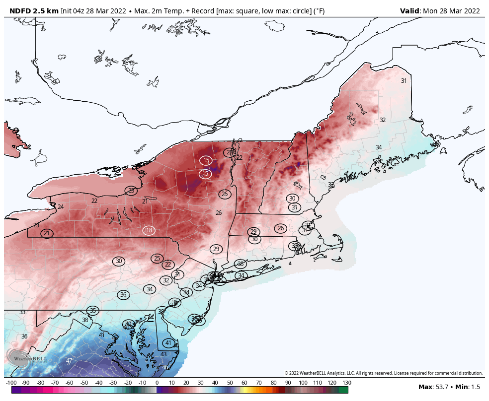
No, Mother Nature is not playing an early April Fool’s joke on us, today really will be quite chilly.
The week starts out on a very chilly note as an upper-level low pressure system slowly moves across the Northeast. We’ll have some sunny breaks today but there will be plenty of clouds and possibly a few snow showers or flurries during the afternoon and evening. Temperatures will be well below normal for late March, with highs only in the 30s, possibly upper 20s in some spots. This will likely break records for the lowest high temperature for the date across much of the Northeast. Add in gusty winds, and wind chills will only be in the teens (or colder), so bundle up if you’re heading outside today. Skies will clear out tonight as high pressure builds in, resulting in a rather cold night, possibly setting low temperature records in spots, as lows drop into the teens in many locations.
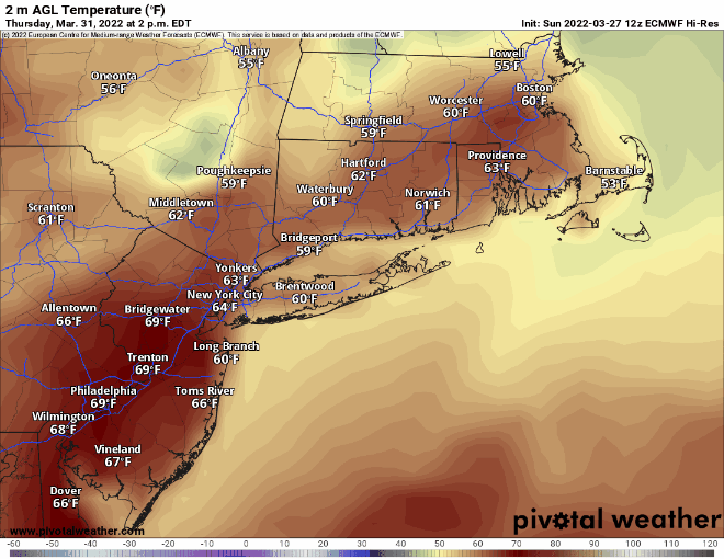
High pressure starts to slide off to the east on Tuesday, allowing temperatures to begin to moderate, but it will remain on the chilly side. Wednesday should be milder, but clouds will start to stream into the region as a complex low pressure system heads into the Great Lakes. That system will send a warm front toward the region on Thursday. Ahead of the warm front, we could see a little snow or sleet Wednesday night, especially across the interior. Milder air should eventually move in for Thursday as the warm front finally pushes through, but rain showers are likely Thursday night into early Friday before the storm sends a cold front across the region. How quickly that warm front moves through on Thursday will determine our temperatures. Some of the guidance is showing the potential for temperatures well into the 60s, but some of the models don’t bring the warmer air into the Merrimack Valley or southern New Hampshire until late afternoon or evening, resulting in a much cooler day. Steady rain ends early Friday, but some showers could linger during the day. Next weekend looks dry and cooler as high pressure builds back in.
Monday: Intervals of clouds and sunshine, blustery, chance for a few snow showers or flurries. High 27-34.
Monday night: Becoming clear to partly cloudy, breezy, and cold. Low 14-21.
Tuesday: Morning sun, afternoon clouds, still breezy. High 34-41.
Tuesday night: Mostly clear. Low 19-26.
Wednesday: Early sun, then clouds increase and thicken. A few showers possible at night, maybe mixed with sleet or snow across the interior. High 42-49.
Thursday: Cloudy and breezy with showers likely. High 55-62, possibly a little cooler across southern New Hampshire.
Friday: More clouds than sunshine, breezy, chance for a few more showers. High 56-63.
Saturday: Partly sunny, breezy, and cooler. High 46-53.
Sunday: A mix of sun and clouds. High 50-57.
