We are finally ready to type the phrase you’ve all been waiting months to read – “Winter is over.”. We are done with snow until at least October, probably even later than that. Temperatures should finally start feeling like Spring as well. That doesn’t mean this week will be all sunshine and warm days.
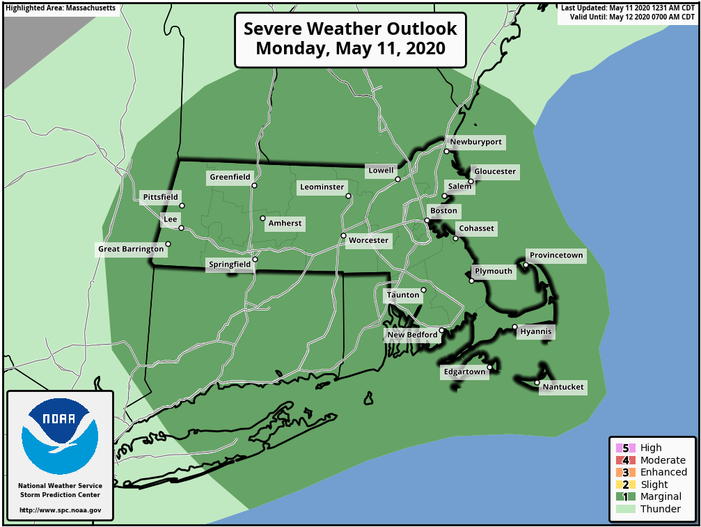
We start the week off with low pressure heading out of the Great Lakes and towards New England today. It will send a warm front across the region this morning, with some showers likely. Once they move out, we’ll see some sunshine develop allowing temperatures to get fairly mild. However, a cold front will be approaching from the west and it will produce some showers and thunderstorms by late afternoon. A few of these storms may get quite strong, especially across the interior, with gusty winds and heavy downpours possible. With very cold air still in place aloft, we could also see some hail with any stronger storms that develop.
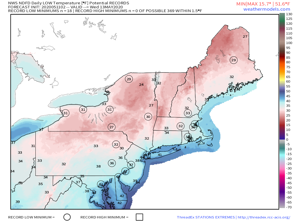
Everything moves offshore during the evening and then high pressure builds in with clearing Monday night. This will bring some chilly air back in for Tuesday and Wednesday. An upper-level low moves through on Tuesday, producing some afternoon clouds and possible a few sprinkles. Skies will clear out Tuesday night as the high really settles in, and we could be looking at record low temperatures Wednesday morning with frost likely for much of the region. We’ll remain on the chilly side (relative to May) on Wednesday.
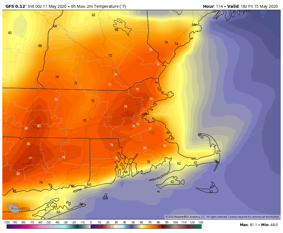
The high slides offshore on Thursday, with temperatures starting to warm up once again. We may start to see some clouds stream in late in the day ahead of the next system moving into the Great Lakes. The system will send a warm front across the region Thursday night, with another round of showers expected. As the system passes to the north, we’ll see much warmer air move in on Friday, with gusty winds winds and some sunshine allowing temperatures to rise into the 70s. However, another cold front moves through late in the day, with more showers or thunderstorms possible.
This brings us to next weekend, where there is plenty of uncertainty in the forecast. High pressure builds in on Saturday with dry weather, and temperatures may remain warm. However, as that high slides off into Atlantic Canada, it will send a backdoor cold front down the coast Saturday night and into Sunday. Sunday could still end up a decent day well inland (say from the Connecticut Valley westward), but the closer you are to the coast, the more likely you’ll experience east to northeast winds, possibly some drizzle and/or fog, and temperatures in the 50s (or even 40s) during the afternoon. Beyond that, there are some signals that temperatures could be on the warm side for at least a few days next week.
Monday: Morning clouds and showers, then becoming partly sunny and breezy. High 57-64.
Monday night: Clearing. Low 35-42.
Tuesday: Morning sunshine, afternoon clouds, possibly a sprinkle, breezy. High 49-56.
Tuesday night: Clear and chilly. Low 31-38.
Wednesday: Sunshine and a few afternoon clouds, still breezy. High 52-59.
Thursday: Plenty of sunshine, but some high clouds may start to stream in during the afternoon. High 59-66.
Friday: Morning showers, then becoming partly sunny, breezy, and warm. High 70-77, cooler right along the South Coast, and possibly along the NH Seacoast.
Saturday: Partly to mostly sunny. High 64-71, cooler along the coast.
Sunday: Partly sunny, low clouds, drizzle, and fog possible along the coast. High 50-57 along the coast, 58-65 inland.
