It’s coming. The day you’ve been dreading for a while. For some of us, that day will happen this week. That’s right, the first snowflakes of the season could occur within the next 7 days.

The week starts off on a bright but chilly note with high pressure in control. We’ll have some sunshine today, but clouds move in this afternoon as low pressure starts to move towards the region. This system will bring in another shot of rain, possibly heavy on Tuesday, because we haven’t had enough rain yet this fall. The rain may start as some wet snow in parts of central and southern New Hampshire, but for the majority of us, this will be a rain event. The rain will continue for much of the day, tapering off around dinner time, but it’s the evening and overnight hours that we’re actually concerned about.
As the storm pulls away Tuesday night, gusty northwest winds will usher some of the coolest air so far this fall into the region. Temperatures will drop rather quickly Tuesday night, so any roads that are still wet could start to ice up during the evening, mainly from the Merrimack Valley northward. So, if you’re heading out Tuesday evening, be careful and pay a little more attention to the roads you’re on. Skies clear out Tuesday night as high pressure builds in, setting up Wednesday with sunshine along with windy and cold conditions. Winds will diminish late in the day, which means that Wednesday night will be quite chilly with clear skies and light winds setting up a good night for radiational cooling.
Thursday will be a lot like today. We’ll start off with sunshine and chilly conditions, but clouds will start to move om ahead of another storm system. While this storm will likely bring another round of locally heavy rain in Thursday night and Friday, it may not be all rain. we’ll be starting off cooler than today. The precipitation may start as snow, even into the Boston area, but a change to rain is expected. Some accumulations are possible before the changeover, especially across southern New Hampshire and possibly the Merrimack Valley. The rain ends on Friday, then high pressure builds in for the weekend with breezy and cold conditions once again. don’t be surprised if a few flurries develop as an upper-level low pressure system crosses the region.

Monday: Sunny and chilly to start, clouds move in during the afternoon. High 42-49.
Monday night: Becoming cloudy with rain developing after midnight, possibly mixed with some wet snow in southern New Hampshire. Low 35-42.
Tuesday: Rain, heavy at times through early afternoon, tapering off and ending late in the day. Becoming breezy. High 45-52, warmer across southeastern Massachusetts, southern Rhode Island, and Cape Cod.
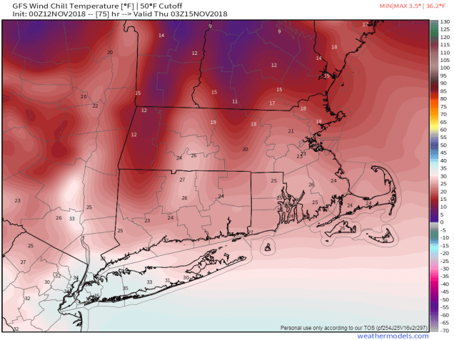
Tuesday night: Clearing and windy. Low 24-31.
Wednesday: Mostly sunny, windy, and colder. Winds diminish late in the day. High 31-38.
Thursday: Sunny and cold early, clouds move back in during the afternoon. Snow develops at night, changing to rain before daybreak from south to north. High 33-40.
Friday: Rain, possibly heavy at times, ending in the afternoon. High 41-48.
Saturday: A mix of sun and clouds, breezy, chance for a few rain or snow showers. High 40-47.
Sunday: Partly sunny, slight chance for a snow flurry. High 30-37.
