Labor Day Weekend is coming up? Summer is definitely fading, except that you won’t notice that for the next few days. That’s right, a late-summer heat wave is settling in.
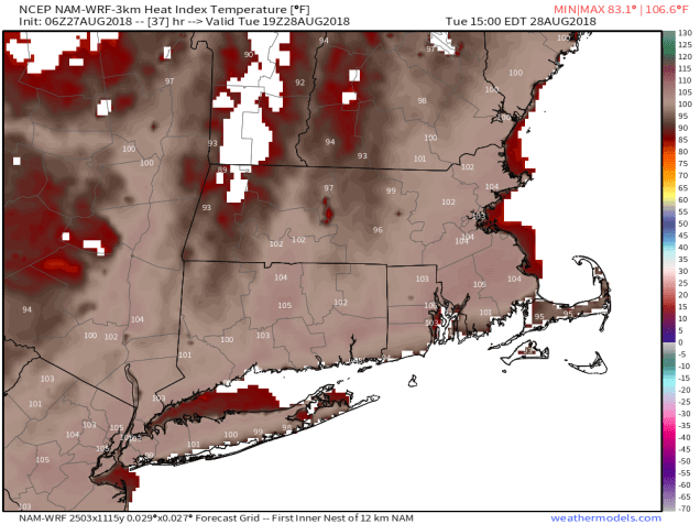
A ridge of high pressure will settle into the East Coast for the next few days while at the surface high pressure remains in place off the East Coast. That means hot and humid conditions through the middle of the week. Heat Advisories and Excessive Heat Watches are in effect across much of the Northeast. High temperatures will get well into the 90s for much of the area, but when you factor in the dewpoints well into the 70s, the heat index will be well over 100.
A cold front comes through on Thursday, triggering some showers and thunderstorms, and bringing cooler and drier air in. Behind that front, high pressure settles into eastern Canada. Labor Day Weekend might start off quite cool, but as the high slides off to the East, temperatures will start to warm up for the latter half of the holiday weekend. There is one potential fly in the ointment. That front that is coming through on Thursday is likely going to stall out south of New England. Depending on how close it stalls, it may keep clouds and possibly some showers in place, especially along the South Coast. We’ll see how that plays out as we get later on the week.
Monday: Sunshine and a few clouds. High 85-92.
Monday night: Clear to partly cloudy. Low 67-74.
Tuesday: Mostly sunny, hot, and humid. High 90-97.
Tuesday night: Clear skies. Low 71-78.
Wednesday: Mostly sunny, hot, and humid again. High 90-97.
Thursday: A mix of sun and clouds, chance for some showers and thunderstorms. High 86-93.
Friday: Partly sunny and less humid. High 70-77.
Saturday: Partly to mostly sunny. High 68-75.
Sunday: A mix of sun and clouds. High 75-82.
Labor Day: Intervals of clouds and sunshine, chance for a few showers. High 80-87.

