We’ve got a lot of different types of weather coming up this week, starting with some snow today, and that’s not an April Fools joke.
The week actually starts off with some light snow for parts of the area. A storm system will pass south of New England today, with a period of light snow likely during the morning, mainly south of Route 2. This will not be a big deal, as there are several factors working against this system.
- It will be fast-moving, with snow moving in around the morning rush hour and ending around midday.
- Temperatures will be near or above freezing when most of the precipitation falls.
- Since it’s early April,, the sun angle is high enough that it’ll be tough to accumulate on paved surfaces unless it comes down very hard.
- Dry air in place at the start will evaporate some of the snow before it hits the ground.
Add up all those factors, and you don’t much snow accumulation. In fact, we’re only expecting 1-2 inches on grassy surfaces, mainly from Boston southward. A few places could pick up 3 inches, but that’s about it. Not a big deal.

Skies clear out during the afternoon, but clouds quickly come back in at night as a warm front starts to approach the region on Tuesday. We’ll have rain moving back in during the afternoon and evening, possibly mixed with a little wet snow in a few spots. The warm front comes through overnight, with temperatures rising after midnight. Wednesday will be a cloudy and mild day, but a cold front will be approaching from the west. This will produce more showers and maybe even a thunderstorm. Temperatures drop quickly behind the front Wednesday evening.
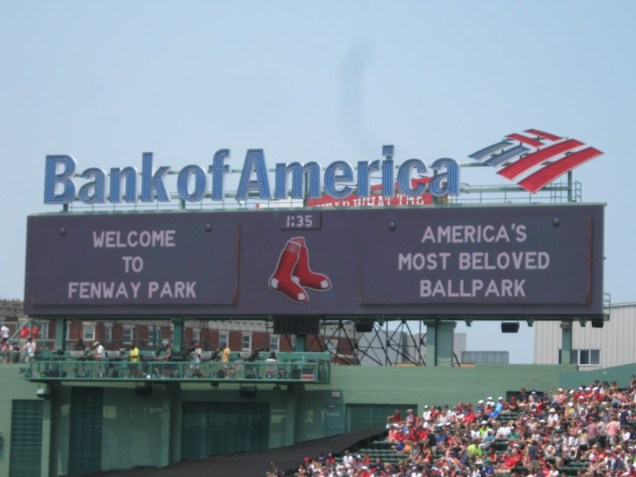
This brings us to the most important day of the week – Thursday. Why is Thursday the most important day? It’s the Red Sox home opener at Fenway! Last year, the opener was on April 3, against the Pittsburgh Pirates, and it was, partly cloudy, breezy, and 48 degrees at game time. This year, it’ll be partly cloudy and breezy once again, but it’s probably not going be 48 degrees at game time. We’ll probably need to shave about 3 or 4 degrees off of that. If you have tickets, dress like you’re going to a Pats game in November.
Clouds stream back in later in the day as another weak system approaches. This system will bring in some light rain or snow Friday into early Saturday, but again, this will not be a big deal, with little to no accumulation expected. High pressure then builds back in later on Saturday and into Sunday. Having said that, some of the models are showing the potential for a storm system to impact the region on Sunday. We’re not ready to jump on board with this just yet, but it would not be unprecedented. Most of us remember the April Fools Day storm from 1997, but how many people remember the April 6-7, 1982 storm? Temperatures stayed in the teens and 20s during that storm. We also had back-to-back storms April 7-8 and April 9-10 in 1996, which dropped a combined 8-20 inches of snow on the area. If this storm starts looking more likely, we’ll let you know later in the week.

Monday: Light snow likely in the morning, mainly south of Route 2, then some sunshine may return in the afternoon. High 39-46.
Monday night: Partly cloudy in the evening, then becoming cloudy again after midnight. Low 27-34.
Tuesday: Mostly cloudy with showers developing in the afternoon. High 41-48.
Tuesday night: Cloudy and breezy with occasional showers. Low 36-43 in the evening, then temperatures rise after midnight.
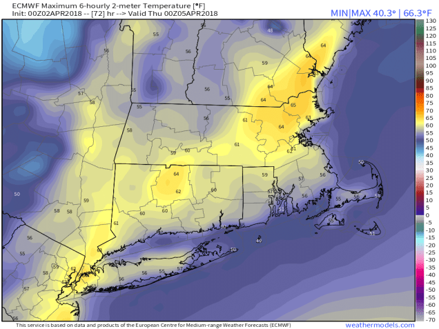
Wednesday: Windy and mild with more showers possible, maybe even a rumble of thunder. High 57-64, coolest along the South Coast.
Thursday: Partly to mostly sunny, breezy, and colder. High 39-46.
Friday: Mostly cloudy and breezy with some light rain or snow possible, especially late in the day and at night. High 44-51.
Saturday: Chance of light rain or snow early, then becoming partly sunny. High 37-44.
Sunday: A mix of sun and clouds. High 40-47.
