This may be one of the shortest blog posts we’ve ever written, because the forecast for this week is ridiculously simple.
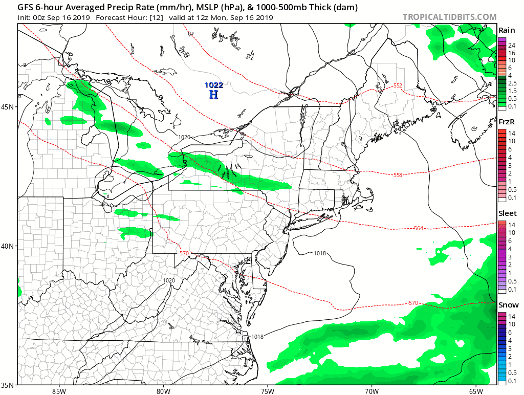
As you can see in this loop of the GFS model, there will be little to no rainfall this week across our area. Also, unless you’re taking a boat offshore, you don’t have to worry about Hurricane Humberto either. Loop provided by Tropical Tidbits.
A weak disturbance will cross the region today, with some clouds and maybe a shower or two here or there. Maybe. We’re not even convinced that any will pop up. A weak backdoor cold front may produce a few showers early Wednesday, mainly along the coast. Otherwise, high pressure is in control for most of the week and into the weekend. It’ll be on the cool side for Tuesday into Thursday, then we’ll warm up for Friday and the weekend. That’s it. That’s the forecast for the week. Really.
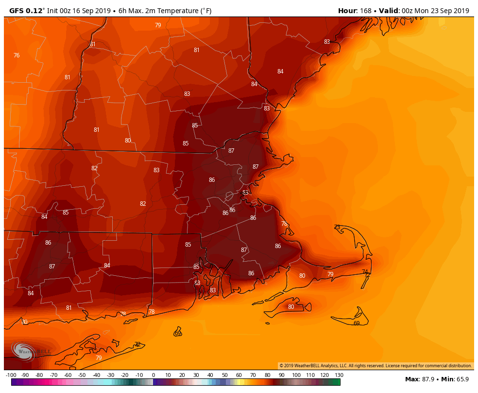
Sunday is the last day of (astronomical) summer, and the GFS thinks it’ll be a warm one. Image provided by WeatherBell.
Monday: Partly to mostly sunny north of the Mass Pike. Intervals of clouds and sunshine south of the Pike with just a very slightly chance for a shower. High 68-75.
Monday night: Clear skies. Low 47-54.
Tuesday: Sunshine and a few clouds. High 64-71.
Tuesday night: Becoming partly to mostly cloudy, chance for a few showers or some drizzle, mainly along the coast. Low 48-55.
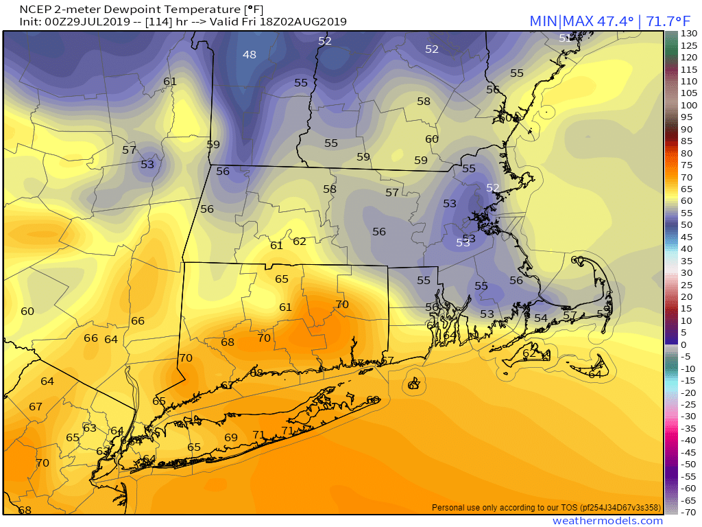
Wednesday: A shower or some drizzle early, then becoming partly sunny. High 61-68, coolest along the coast.
Thursday: Unlimited sunshine (from sunrise to sunset only). High 65-72, coolest along the coast.
Friday: Wall-to-wall sunshine. High 72-79.
Saturday: Sun, sun, and more sun. High 76-83.
Sunday: Mostly sunny, maybe a couple of clouds just for a chance of pace. High 78-85.
No hurricanes to worry about this week, just a cold front one day, and high pressure for most of the rest of the week.
We start the week off with high pressure in control, keeping us on the cool side today and Tuesday. Temperatures will actually be a little bit below normal for mid-September. The cool and dry weather won’t last though, as a warm front moves through Tuesday night, likely producing a few showers as it comes through. Once the front its through, we’ll have some warm and somewhat humid conditions around for Wednesday. We will have another cold front coming through late Wednesday or early Thursday. This front may produce another round of showers and thunderstorms. Thursday’s temperatures will be determined by when that front comes through. The longer it takes, the better the chance that Thursday is also a warm day, which is the way we’re leaning right now.
High temperatures are normally in the middle 70s at this time of year. Image provided by Weathermodels.com
High pressure builds in behind the front, with cooler weather likely on Saturday, but again, it will be short-lived. As the high slides off to the east, we’ll warm up again on Saturday before another cold front approaches, possibly producing some more showers or thunderstorms. That front looks like it won’t do much, as Sunday could be another warm day. In fact, it’s looking like a good chunk of next week could be warm, with temperatures getting into the 80s. Don’t put away those summer clothes just yet!
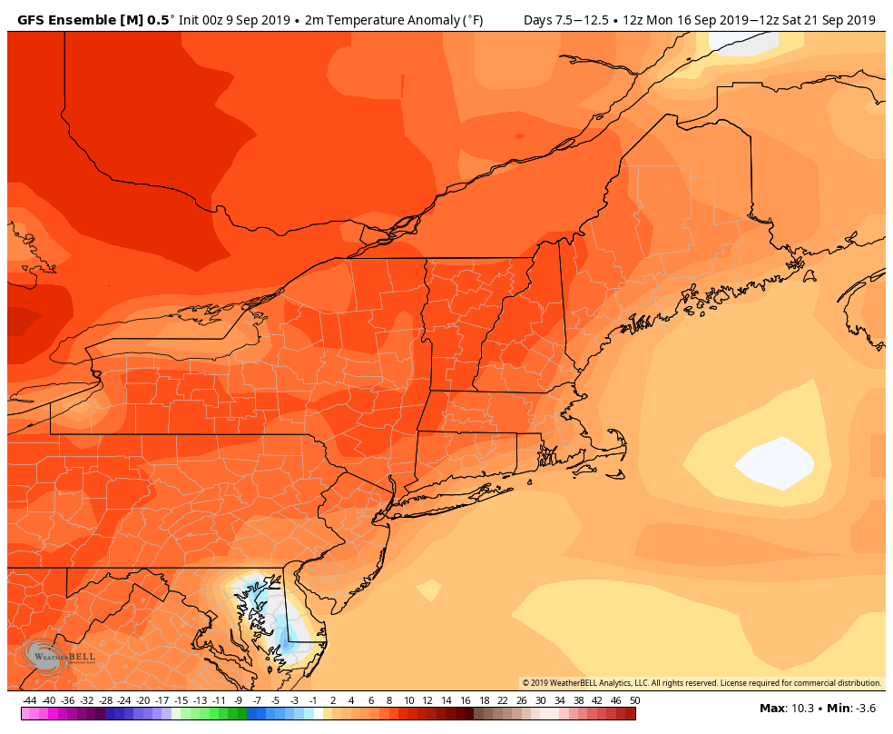
Temperatures may average several degrees above normal next week, with highs above 80 possible more than a few times. Image provided by WeatherBell.
Monday: Intervals of sunshine and clouds. High 67-74, coolest right along the coast.
Monday night: Clear to partly cloudy. Low 48-55.
Tuesday: A sunny start, clouds move in during the afternoon. High 68-75, coolest right along the coast.
Tuesday night: Partly to mostly cloudy with some showers possible. Low 55-62.
Wednesday: A shower or two early, then becoming partly sunny and breezy. High 78-85.
Thursday: A mix of sun and clouds, slight chance for a shower or thunderstorm. High 75-82.
Friday: Partly to mostly sunny. High 64-71.
Saturday: More clouds than sun, breezy, showers and thunderstorms possible late in the day. High 74-81.
Sunday: Partly sunny, chance for a shower or thunderstorm. High 76-83.
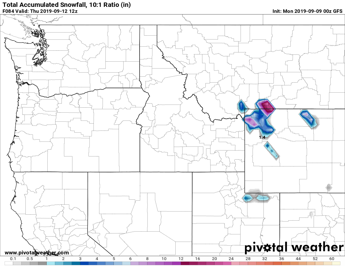
It’s getting to be that time of year. Some higher elevation snow is possible in parts of Wyoming and Montana on Wednesday. Image provided by Pivotal Weather.
Believe it or not, there is weather besides Dorian taking place right now, and some of it will impact us. Oh Dorian may at some point as well, but we’ll get to that.
The week starts off with a cold front approaching from the west. If you’ve got outdoor plans for Labor Day, you should be OK through at least midday. Although we’ll have plenty of clouds around, the showers and thunderstorms we’re expecting should hold off until the afternoon. Some of these showers and storms could produce some heavy rainfall, especially during the late afternoon and evening hours.
The front pushes offshore, with showers ending overnight, then high pressure builds in for Tuesday with mild and drier conditions. The high shifts offshore on Wednesday, allowing warmer and more humid air to move back in. Temperatures should be well into the 80s, and a few places could even get to 90. However, another cold front will move through late in the day, with some additional showers likely. Behind that front, much cooler air settles in on Thursday with high pressure building back in.
Temperatures should get well into the 80s on Wednesday. Image provided by WeatherBell.
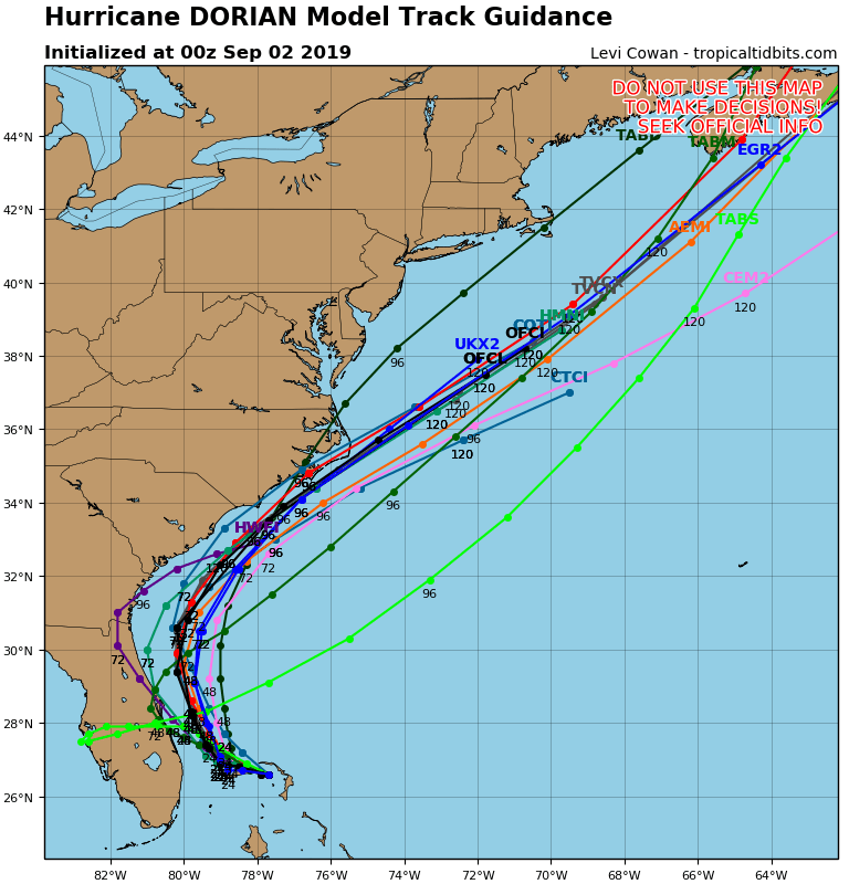
This brings us to the Dorian part of the forecast. If Dorian is to have any impact up here, it will be in the Friday/Saturday time frame. Dorian will produce some rough surf along the coastline, but beyond that, we’re not sure if there will be any other impacts. A lot will be determined by the track that Dorian takes, but it should pass well south and east of New England. Whether it’s still a hurricane, a tropical storm, or even an extratropical storm, is too tough to predict this far out. Some of the models have it pass close enough to bring in some heavy rain and gusty winds, especially to Cape Cod and Southeastern Massachusetts. Some of the local TV meteorologists were already hyping this up on the 11pm news Sunday night. Sure, it’s possible that this could happen. It’s also possible that the storm stays far enough offshore to have little to no impact on us beyond the rough surf. For now, we’re going to play the middle ground on the forecast, but obviously, we’ll be doing some special blog updates on Dorian during the week, as it’s future becomes more clear.
Most of the forecast models keep Dorian well south and east of New England, for now. Image provided by Tropical Tidbits.
High pressure will be building into the Northeast for the end of the week and the weekend. If Dorian stays too far offshore, it will be dry and cool around here for Friday through Sunday. If Dorian does have some impact, it’ll just be dry and cool on Sunday behind the storm.
Labor Day: Mostly cloudy with showers and thunderstorms likely in the afternoon. Some of the storms may produce heavy rainfall. High 70-77.
Monday night: Showers and thunderstorms ending, followed by clearing late at night. Low 56-63.
Tuesday: Clouds may linger across Cape Cod in the morning, otherwise partly to mostly sunny. High 74-81.
Tuesday night: Clear to partly cloudy. Low 58-65.
Wednesday: Becoming partly to mostly cloudy, breezy, and humid, with showers and thunderstorms likely during the afternoon. High 80-87.
Thursday: Sunshine filtered through increasing high clouds streaming northward from Dorian. High 67-74.
Friday: Partly to mostly cloudy, breezy, and cool with a chance of rain, especially south of Boston. High 63-70.
Saturday: Breezy with a chance of rain early, then becoming partly to mostly sunny. High 69-76.
First, our apologies for the brief post last week and the missing temperatures in the forecast. We at Storm HQ were taking a cruise to Bermuda for a much-needed vacation, and our internet connection on the ship was even worse than expected. It took far too long to even get what we wrote posted. We’re back in the Storm HQ World Headquarters Compound now, so we’re back to full updates.
It’s a chilly start to the week, with many locations dropping into the 40s north and west of Boston this morning. Image provided by Weathermodels.com
As for the coming week and the upcoming Labor Day Weekend, we’ll start off with high pressure in control, providing the region with dry and cool conditions today, but a warming trend is expected over the next few days. Some low clouds may remain in place this morning along the coast, thanks to the onshore flow around the high pressure area to our north and a deepening system south of Nova Scotia. The high pressure system will eventually win out, with sunshine developing along the coast by afternoon as well.
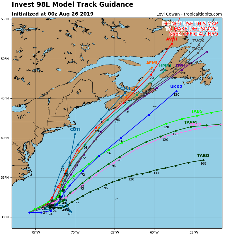
A cold front will start to approach the region on Wednesday, which means we should turn warmer and more humid, but there’s a possible fly in the ointment. There’s a system off the Carolinas right now that could become a tropical or subtropical storm later today (we’ll likely have a special blog post about this storm and Dorian either later today or on Tuesday). Right now, this system looks like it will head towards the northeast, and stay well offshore, but that is not set in stone yet. A track more towards the north-northeast could bring it close enough to at least bring in some clouds to southeastern New England. A return of onshore flow would mitigate any warm and humid weather along the coast, and depending on how close the system passes, we could even see a few showers reach the Outer Cape and the Islands. Obviously, we’ll keep an eye on this situation over the next few days. We think it’s a low-probability that it has an impact on us, but that probability is nowhere near zero right now.
How close will a potential tropical system come to New England? Probably not close enough to have much impact, but it’s possible. Image provided by Tropical Tidbits.
Back to that cold front, it likely produce some showers and a few thunderstorms Wednesday night into Thursday before it moves offshore. High pressure builds in behind the front on Friday with some drier weather, but another cold front moves will approach on Saturday. This one doesn’t look like it will have much moisture to work with, so we’re only expecting a few showers. High pressure builds in behind the front with cooler weather on Sunday. For Labor Day on Monday, the “traditional end of summer”, it looks like we’ll turn a littler warmer again as the high starts to move offshore.
You’re probably wondering if we’re done with the heat for the year. The answer is “not likely”. We’ve had plenty of 90-degree days well into September (and on very rare occasions into October. In fact, at least one model is showing some very warm weather the following weekend, with temperatures well into the 80s and close to 90 again. It’s nearly 2 weeks away, so it’s hardly set in stone, but don’t take the air conditioner out of the window and out away your summer clothes just yet.
Could we have some heat return next weekend? One model thinks so. We’ll see what happens over the next 10 days. Image provided by WeatherBell.
Monday: Low clouds linger across southeastern Massachusetts in the morning, bright sunshine everywhere in the afternoon. High 68-75, coolest along the coast.
Monday night: Clear skies. Low 47-54, warmest in the urban areas.
Tuesday: Sunshine and some afternoon clouds. High 71-78.
Tuesday night: Mostly clear. Low 53-60.
Wednesday: Partly to mostly sunny. Clouds move in at night with some showers possible towards daybreak. High 75-82, a little cooler along the coast.
Thursday: Intervals of clouds and sunshine with scattered showers, possibly a thunderstorm, mainly during the morning. High 77-84.
Friday: Plenty of sun. High 78-85.
Saturday: Partly to mostly sunny, some showers are possible at night. High 79-86.
Sunday: A mix of sun and clouds. High 71-78, coolest along the coast.
Labor Day: A sunny start, then clouds move in. High 73-80.
Since this forecast is being written from the North Atlantic (somewhere around 39N/73W), and after a few mojitos, we’ll keep it simple this week. The graphics and sarcasm will return next week.
Basically, we’ve got hot and humid conditions through Thursday with high pressure sitting offshore. A few showers and thunderstorms may pop up each day, but especially Wednesday and Thursday as a cold front moves through. High pressure then builds in with drier and cooler conditions for Friday and the weekend.
Monday: A mix of sun and clouds, a few showers and thunderstorms are possible.
Monday night: Partly cloudy, and showers or storms end in the evening.
Tuesday: Partly sunny, chance for an afternoon shower or thunderstorm.
Tuesday night: Partly cloudy.
Wednesday: Intervals of sun and clouds, showers and thunderstorms likely in the afternoon.
Thursday: More clouds than sun with scattered showers and thunderstorms.
After a pretty- good weekend weatherwise, we’ve got another decent day today, though humidity levels will start to creep up. After that, there’s some rain in our future.
High pressure remains in control today, but it will be offshore, so we’ll see moisture start to move into the region. You’ll notice it both at the surface, where dewpoints will start to creep up, and later of aloft, as some clouds start to move into the region. A few showers are possible Monday night as a cold front starts to approach the region, but the bulk of the activity will wait until Tuesday when the front moves through. Some thunderstorms are also possible, especially towards the South Coast where there is the potential for some heavy downpours.
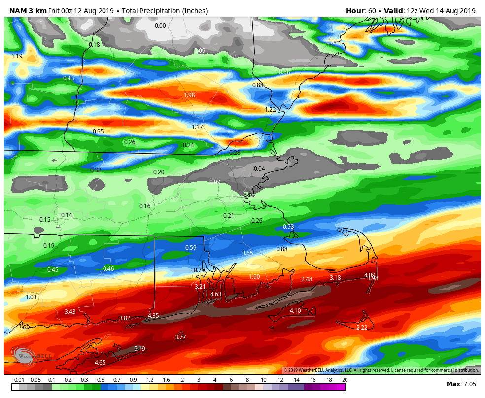
This may be a bit too much, but the NAM continues to insist on some very heavy rainfall along the South Coast from Tuesday’s system. Image provided by WeatherBell.
The front pushes offshore Tuesday night then stalls south of New England while high pressure tries to build in to the north. As a result, we may have clouds lingering near the south coast while sunshine dominates farther north.
High pressure building in behind the front could send temperatures into the 40s across much of Northern New England Wednesday morning. Image provided by Weathermodels.com
Another weak disturbance will move through on Thursday with some additional clouds and possibly a few more showers, then high pressure builds in for Friday and the weekend with conditions fairly similar to what we just had this past weekend. This also includes the chance for a few widely scattered pop-up showers. These won’t be an issue for 90-95% of the region, but if you’re one of the unlucky 5-10%, they won’t last too long and shouldn’t be that heavy. Certainly nothing to cancel any plans over.
While we’re talking about next weekend, we just wanted to let you know that next week’s outlook will likely be posted at some point next Sunday morning, and not early Monday morning as usual. We’ll return to the Monday morning posting the following week.
Monday: Morning sunshine starts to fade behind increasing high clouds in the afternoon, becoming humid. High 80-87.
Monday night: Becoming mostly cloudy with a few showers possible, especially across southern New Hampshire and northern Massachusetts. Low 64-71.
Tuesday: Mostly cloudy with scattered showers and thunderstorm. High 77-84.
Tuesday night: Mostly cloudy with scattered showers and thunderstorms lingering across the South Coast and Cape Cod through midnight. Skies may start to clear out after midnight north of the Mass Pike. Low 59-66.
Wednesday: Partly to mostly sunny from the Merrimack Valley northward, intervals of clouds and sunshine elsewhere. High 73-80, coolest along the coast.
Thursday: A mix of sun and clouds, chance for a shower or two. High 72-79.
Friday: Sunshine and some afternoon clouds, slight chance for a shower. High 74-81.
Saturday: Partly to mostly sunny, just a very slight chance for a pop-up shower. High 77-84.
Sunday: Sunshine and some afternoon clouds, but a stray shower is possible again. High 79-86.
We’ve actually got some fairly typical summer-time weather coming up for most of the week. Nothing too extreme, just warm and humid weather for a few days with a daily chance for thunderstorms, followed by cooler and drier weather late in the week.
We start the week off with a cold front pushing farther offshore and high pressure building in today. This will result in seasonably warm temperatures and low humidity. This won’t last long, as a warm front will move through Monday night and early Tuesday. This will allow more humid air to settle back in on Tuesday. With the warm and humid air in place, a few showers and thunderstorms may develop Tuesday afternoon.
Dewpoints will be mainly in the 50s across the region this afternoon. Image provided by Weathermodels.com
As we get into Wednesday, a slow-moving cold front will start to approach from the west. The front likely won’t move through until Thursday night or Friday morning, but again, we’ll have warm and humid conditions in place, and the approaching front will help to trigger showers and thunderstorms both Wednesday afternoon and again Thursday afternoon. Some of these storms could become strong to severe, with gusty winds, hail and heavy downpours in some of the stronger storms. It’s not going to rain all day, but if you’ve got outdoor plans Wednesday and Thursday, keep an eye to the sky during the afternoon and evening both days.
Thunderstorms could drop some heavy rainfall on the region during the middle of the week. Image provided by WeatherBell.
The front finally pushes through early Friday, but an upper-level low pressure area will move across the Northeast. So, even though we’ll have some drier air moving in, a few pop-up showers and thunderstorms will be possible once again. High pressure then builds in for the weekend with cooler and drier conditions. In fact, temperatures could even end up a little below normal.
An upper-level low pressure area will help usher in some cooler weather for Friday and the weekend, Image provided by Pivotal Weather.
Monday: Sunshine and a few afternoon clouds. High 79-86.
Monday night: Clear to partly cloudy. Low 59-66.
Tuesday: Partly sunny and becoming humid, chance for a few showers and thunderstorms during the afternoon. High 80-87.
Tuesday night: Partly to mostly cloudy, some additional showers and storms are possible, mainly in the evening. Low 64-71.
Wednesday: Intervals of clouds and sunshine with scattered showers and thunderstorms developing. High 80-87.
Thursday: Partly sunny with another round of showers and thunderstorms possible. High 81-88.
Friday: Sunshine and some afternoon clouds, breezy, slight chance for a shower or thunderstorm. High 78-85.
It’s back! The heat and humidity has returned, much to the delight of some, and dismay of others (count us among the “others”). It won’t hang around for too long though, but there’s not exactly any “cool” weather in our future.
Heat Advisories have been issued for parts of the region for Monday and Tuesday (shaded in orange on the map). Image provided by the National Weather Service.
We start the week off with high pressure anchored off the East Coast. This will result in southwesterly winds pumping warm and humid air into the region for Monday and Tuesday. Many places will likely top 90 once again, and with dewpoints remaining high, heat indices could approach 100 during the afternoons. Heat Advisories have been posted for parts of our area.
The heat index will be in the middle to upper 90s across the region Tuesday afternoon. Make sure you’re prepared if you’ll be outside. Image provided by WeatherBell.
Some spotty relief is possible during the next couple of afternoons, as some showers and thunderstorms will likely develop each day. Some of these storms could produce hail, heavy downpours, and strong winds, but a widespread severe weather outbreak is not expected. Showers and storms will become more numerous on Wednesday as a cold front approaches the region. This front will be fairly weak, but it should push through by early Thursday. Behind it, some drier air will move in, along with slightly cooler conditions for Friday.
Dewpoints in the 50s on Friday is fine by us. Image provided by Weathermodels.com
Right now, next weekend looks like it will be a typical summer weekend across the area. We’ll have temperatures in the 80s, moderate humidity levels, and some pop-up showers and thunderstorms to contend with. Nothing to cancel plans over, but something you’ll need to keep an eye on if you plan to be outdoors.
Monday: Sunshine and some afternoon clouds, chance for a pop-up shower or thunderstorm. High 85-92.
Monday night: A shower or thunderstorm during the evening, otherwise becoming clear to partly cloudy and muggy. Low 66-73.
Tuesday: Partly to mostly sunny, breezy, humid, chance for a few pop-up showers or thunderstorms again. High 88-95, a little cooler along the south coast.
Tuesday night: Partly cloudy. Low 66-73.
Wednesday: Intervals of clouds and sunshine, showers and thunderstorms becoming more likely, especially from late afternoon into the overnight hours. High 83-90.
Thursday: Any lingering showers end early, then becoming partly to mostly sunny and less humid. High 80-87, coolest along the coast.
Friday: Sunshine and some afternoon clouds. High 79-86, coolest along the coast.
Saturday: A mix of sun and clouds, chance for an afternoon shower or thunderstorm. High 81-88.
Sunday: Partly sunny, a shower or thunderstorm is possible again. High 84-91, cooler along the coast.
The heat and humidity are gone (for now), but some rain is in our immediate future, but much of this week should end up being rather nice.
A cold front moved across the region last night, bringing an end to our heat wave, and taking the humidity away as well. However, that front stalled out south of Long Island, and it will remain there today. It’ll still be warm today behind the front, but closer to what we should experience during the latter half of July. A wave of low pressure will ride along the front, and it will produce some showers and thunderstorms across the area this afternoon and evening. A few of these storms may contain gusty winds and heavy downpours, but a severe weather outbreak is not expected.
Some heavy rainfall amounts are possible over the next couple of days. Image provided by Weathermodels.com
A second wave of low pressure will ride along the front on Tuesday, bringing in another round of showers and thunderstorms. Some of these storms may produce heavy downpours, which could lead to some localized flooding. One other thing you’ll notice is that it will be much cooler with plenty of cloud cover for most of the day. Many places may stay in the upper 60s to lower 70s throughout the day.
At least one model keeps temperatures in the 60s all day on Tuesday. We don’t think it’ll be quite that cool, but it’s certainly possible. Image provided by WeatherBell.
The front sags a little more southward on Wednesday as another wave of low pressure rides along it. This one will likely stay too far south to have any impact on us, except possibly Nantucket and Martha’s Vineyard, but we’ll certainly keep an eye on it. For the rest of us, high pressure starts to build back in at the surface, but with an upper-level low pressure area moving through, we’ll see clouds sprout up in the afternoon, with a stray shower or thunderstorm not out of the question.
From Thursday through Sunday, high pressure will be in control with generally dry conditions. Temperatures will slowly warm up as we head through this period, as will humidity levels, but in general, they’ll be close to what you’d expect for late July, and nothing extreme like we just had this past weekend.
Monday: Some morning sunshine, then becoming mostly cloudy with some showers and thunderstorms developing in the afternoon. High 79-86.
Monday night: Cloudy and breezy with showers and thunderstorms likely, tapering off after midnight. Low 60-67.
Tuesday: Plenty of clouds with showers and thunderstorms redeveloping in the morning, tapering off late in the day. Some storms may contain heavy rainfall. High 68-75.
Tuesday night: Mostly cloudy. Low 57-64.
Wednesday: Lingering clouds early, especially along the South Coast, then becoming partly sunny. High 74-81.
Thursday: Sunshine and some afternoon clouds. High 78-85, coolest along the coast.
Some people do like it hot. Here at Storm HQ we’re not part of that group, but to each their own.
We’ve largely escaped it so far this summer, but it looks like we’ve got some real heat coming later this week. Before then, we’ve actually got a rather nice stretch of weather coming up.
The week starts off with high pressure in control for Monday with sunshine, warm temperatures, and low humidity levels, a perfect combination for mid-July. The high slides offshore on Tuesday, which will allow humidity levels to start to creep up a little bit. A warm front moves through Tuesday night, with a chance for a shower. By Wednesday, hot and humid air moves in, but it may also come with some showers and thunderstorms during the afternoon. We’re not looking at any severe weather, but it will take the edge off the heat in the afternoon, and also make it even more humid late in the Friday.
Thursday is looking like a fairly wet day right now. What’s left of Tropical Storm Barry will likely move across the region, with widespread showers and thunderstorms. Since it’s a tropical airmass, some of these storms may produce heavy rainfall. It’s not going to be the 10-20 inches they’re getting in the Lower Mississippi Valley, but may be enough to cause a few problems around here.
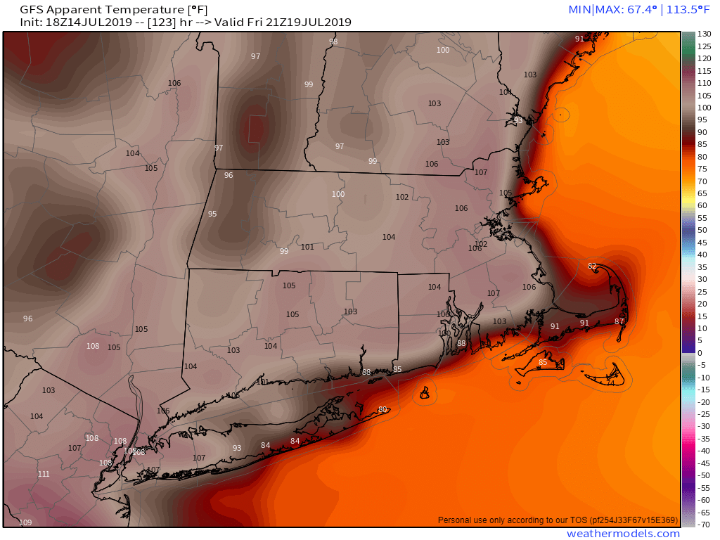
The heat index could be well over 100 Friday afternoon across most of the region. Image provided by Weathermodels.com
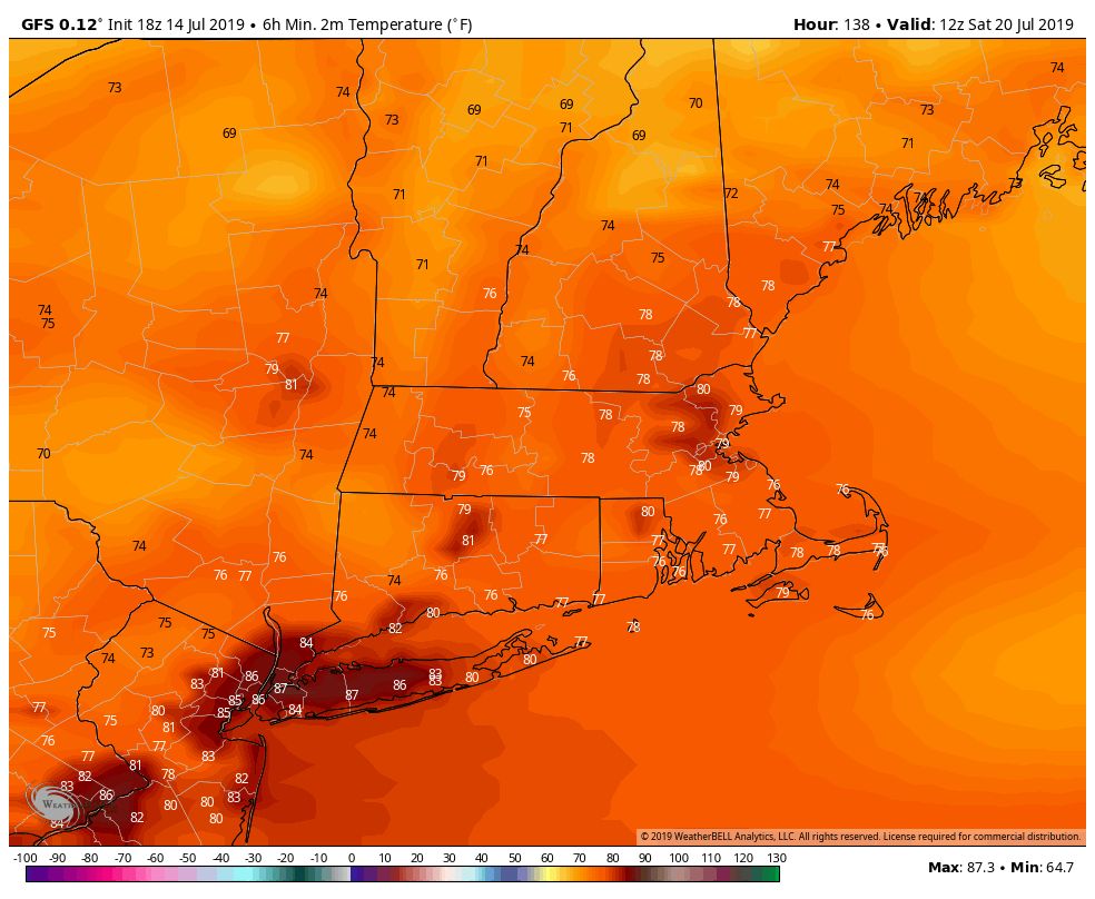
Once ex-Barry pulls away early Friday, things will get hot. It will also remain humid, which means Friday will be a good day to find some air conditioning. If you are going to be outside, make sure you drink plenty of liquids, and wear sunscreen. Temperatures will likely soar well into the middle to perhaps upper 90s across the area. Friday night is looking rather ugly as well for sleeping, as much of the region may not drop below the upper 70s. Some of the cities may stay above 80 all night. Saturday is shaping up to be another hot day, but not quite as humid, with temperatures again in the 90s. Cooler and much drier weather settles in for Sunday.
Low temperatures may stay in the upper 70s to near 80 Saturday morning across the region. Around NYC, temperatures may not drop below the middle 80s. Image provided by WeatherBell.
Monday: Mostly sunny. High 80-87.
Monday night: Clear skies. Low 60-67.
Tuesday: Sunshine and some afternoon clouds. High 83-90.
Tuesday night: Partly cloudy, slight chance for a shower. Low 67-74.
Wednesday: Partly sunny, humid, chance for an afternoon or evening shower or thunderstorm. High 87-94.
Thursday: More clouds than sunshine, scattered showers and thunderstorms likely, some may produce heavy rainfall. High 80-87.
Friday: Lingering clouds early, then becoming mostly sunny, hot, and humid. High 90-97.
Saturday: Sunshine and a few clouds, a late-day shower or thunderstorm is possible. High 90-97.