Believe it or not, there is weather besides Dorian taking place right now, and some of it will impact us. Oh Dorian may at some point as well, but we’ll get to that.
The week starts off with a cold front approaching from the west. If you’ve got outdoor plans for Labor Day, you should be OK through at least midday. Although we’ll have plenty of clouds around, the showers and thunderstorms we’re expecting should hold off until the afternoon. Some of these showers and storms could produce some heavy rainfall, especially during the late afternoon and evening hours.
The front pushes offshore, with showers ending overnight, then high pressure builds in for Tuesday with mild and drier conditions. The high shifts offshore on Wednesday, allowing warmer and more humid air to move back in. Temperatures should be well into the 80s, and a few places could even get to 90. However, another cold front will move through late in the day, with some additional showers likely. Behind that front, much cooler air settles in on Thursday with high pressure building back in.

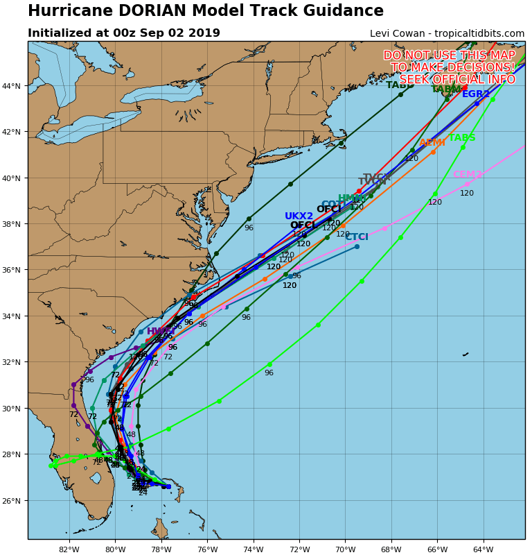
This brings us to the Dorian part of the forecast. If Dorian is to have any impact up here, it will be in the Friday/Saturday time frame. Dorian will produce some rough surf along the coastline, but beyond that, we’re not sure if there will be any other impacts. A lot will be determined by the track that Dorian takes, but it should pass well south and east of New England. Whether it’s still a hurricane, a tropical storm, or even an extratropical storm, is too tough to predict this far out. Some of the models have it pass close enough to bring in some heavy rain and gusty winds, especially to Cape Cod and Southeastern Massachusetts. Some of the local TV meteorologists were already hyping this up on the 11pm news Sunday night. Sure, it’s possible that this could happen. It’s also possible that the storm stays far enough offshore to have little to no impact on us beyond the rough surf. For now, we’re going to play the middle ground on the forecast, but obviously, we’ll be doing some special blog updates on Dorian during the week, as it’s future becomes more clear.
High pressure will be building into the Northeast for the end of the week and the weekend. If Dorian stays too far offshore, it will be dry and cool around here for Friday through Sunday. If Dorian does have some impact, it’ll just be dry and cool on Sunday behind the storm.
Labor Day: Mostly cloudy with showers and thunderstorms likely in the afternoon. Some of the storms may produce heavy rainfall. High 70-77.
Monday night: Showers and thunderstorms ending, followed by clearing late at night. Low 56-63.
Tuesday: Clouds may linger across Cape Cod in the morning, otherwise partly to mostly sunny. High 74-81.
Tuesday night: Clear to partly cloudy. Low 58-65.
Wednesday: Becoming partly to mostly cloudy, breezy, and humid, with showers and thunderstorms likely during the afternoon. High 80-87.
Thursday: Sunshine filtered through increasing high clouds streaming northward from Dorian. High 67-74.
Friday: Partly to mostly cloudy, breezy, and cool with a chance of rain, especially south of Boston. High 63-70.
Saturday: Breezy with a chance of rain early, then becoming partly to mostly sunny. High 69-76.
Sunday: A mix of sun and clouds. High 67-74.
