Memorial Day Weekend Outlook: May 28-31, 2021

Earlier this week we had said that we were being optimistic that the weekend would turn out mostly dry. Yeah, turns out that probably isn’t going to work out.

While high pressure is providing us with a terrific day today, it’s not going to last. Low pressure will move out of the Ohio Valley and ride along a stalled out frontal boundary to our south. That will spread clouds in late tonight, with a cloudy and rather cool day expected on Friday. Rain will develop Friday afternoon, and become heavy Friday night, especially south of the Massachusetts Turnpike. Rain will continue off and on Saturday, finally tapering off later in the day. With plenty of clouds and rain, temperatures on Saturday will be quite chilly for late May, with most places staying in the 50s.

Temperatures will be about 20 degrees below normal on Saturday. Image provided by Weathermodels.com

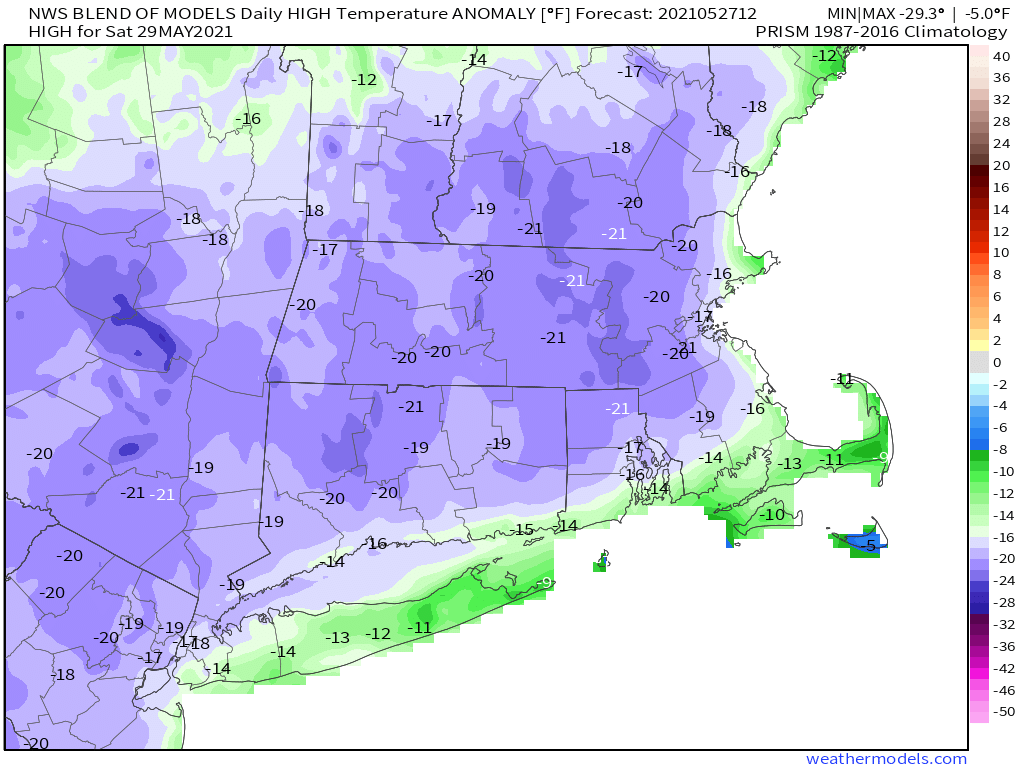
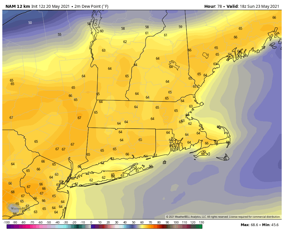
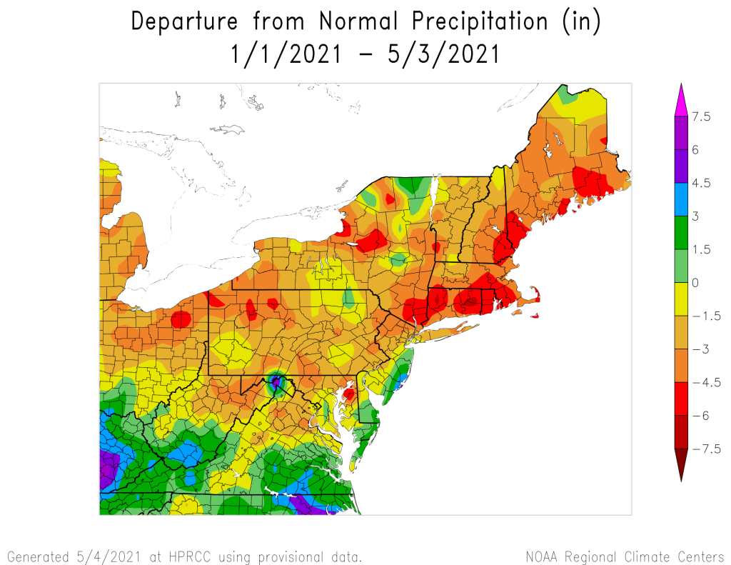
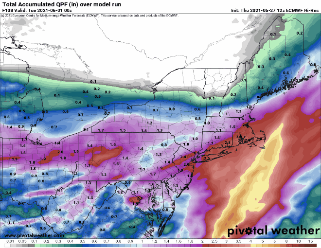
Clouds remain in place Saturday night, then another system moves in later Sunday into at least midday Monday. The first half of Sunday may not be that bad north of the Mass Pike, though still on the chilly side, and Memorial Day afternoon may not be a complete washout. But overall, on a scale of 1 to 10, we’d rate the Memorial Day weekend a 3 at this point. If there’s a bright side to this, after a fairly long dry spell, we’re going to get quite a bit of rain over the next few days, which will not only be good for your lawn and garden, but will wash most of the pollen out of the air (and off your cars). Many of the models may be overdoing the precipitation totals, but a solid 1-2 inches wouldn’t surprise us, especially south of the Mass Pike.

A solid 1-2 inches of rain (or more) is expected this weekend. Images provided by Pivotal Weather.

(Editor’s note: Per a request, we’re going to add a beach and boating forecast to the daytime portions of the Weekend Outlook through Labor Day Weekend)

Thursday night: Partly cloudy. Low 46-53.

Friday: Becoming mostly cloudy with showers developing in the afternoon. High 60-67. Offshore: East winds 10-15 knots, gusts to 20 knots, becoming southeast late in the day, especially for the North Shore. Seas 2-4 feet, visibility lower to 1-3 miles in late-day showers. Water temperatures range from the low 50s off the North Shore to the upper 50s south of the Cape and Islands.

Friday night: Showers becoming a steady rain overnight, breezy. Low 40-47.

Saturday: Showers taper off and end by early afternoon, windy, and chilly. High 48-55. Offshore: Northeast winds 15-25 knots, gusts to 40 knots, especially near Cape Cod. Seas 4-7 feet, visibility under 1 mile in rain.

Saturday night: Mostly cloudy, showers may redevelop along the South Coast toward daybreak. Low 42-49.

Sunday: A few breaks of sun across southern New Hampshire early, otherwise cloudy with showers spreading across the region from south to north. High 51-58. Offshore: Northeast winds 15-20 knots, gusts to 30 knots. Seas 4-8 feet, visibility 1-3 miles in showers.

Sunday night: Periods of rain and showers. Low 43-50.

Memorial Day: Cloudy with rain tapering off and ending by early afternoon. High 57-64. Offshore: North to northeast winds 10-15 knots, diminishing in the afternoon. Seas 3-6 feet, visibility 1-3 miles in showers.

Weekend Outlook: May 21-24, 2021

Our early taste of summer continues through the weekend, but changes are on the way.

High pressure remains in control on Friday with partial sunshine and warm temperatures. We’ll only have partial sunshine as some smoke from wildfires in Canada will drift across the region at times, thanks to our northwesterly flow aloft. A series of weak disturbances will move along that flow over the next couple of days, bringing us some additional clouds and possibly a few showers and thunderstorms, especially late in the day Saturday. Not everyone will get one, so don’t go cancelling any outdoor plans, but keep an eye on the sky (or the radar) if you will be outside.

Sunday could be a very warm day across the region. Image provided by Weathermodels.com

Sunday looks like it’ll be a warm and somewhat humid day (by May standards), but a backdoor cold front will be approaching the region. These fronts usually don’t produce a lot of precipitation, but with the airmass we’ll have in place and another disturbance dropping down, we’ll likely see showers and thunderstorms develop. There will likely be more of them than on Saturday, but the day shouldn’t be a washout. A few of the storms that do form could produce gusty winds and heavy downpours, so again, if you’ve got outside plans, be aware of what’s going on. High pressure builds back in on Monday with much cooler conditions.

Dewpoints could get into the lower to middle 60s on Sunday. Image provided by WeatherBell.

Thursday night: Partly to mostly cloudy, slight chance for a shower, mainly well north of Boston. Low 47-54.

Friday: A mix of sun and clouds, just a slight chance for an afternoon shower, mainly well north and west of Boston. High 79-86, cooler along the coast.

Friday night: Mostly cloudy, a few showers are possible. Low 55-62.

Saturday: More clouds than sunshine, some showers and thunderstorms are possible during the afternoon. High 80-87, cooler along the coast, especially the South Coast and Cape Cod..

Saturday night: Partly cloudy. Low 58-65.

Sunday: Partly sunny, chance for some afternoon showers and thunderstorms. High 83-90.

Sunday night: Clear to partly cloudy. Low 47-54.

Monday: Partly to mostly sunny. High 65-72.

A low pressure area near Bermuda could become a subtropical storm in the next few days. Loop provided by NOAA.

Finally, it’s getting to that time of year – hurricane season. The season officially begins on June 1, and we’ll have a special post dedicated to the start of the season, including statistics about how here in New England we are significantly overdue for a storm. However, there is an area of low pressure northeast of Bermuda that the National Hurricane Center has its eyes on right now. It’s not tropical, but they think it could become subtropical in the next day or two as it heads southwestward toward Bermuda. We’re not sure if it will become subtropical or not, but then again, that’s not our call. They’ll likely waste the first name of the season (Ana) on the storm, which will make seven years in a row that we get a “named” storm before the official start of hurricane season. Over the weekend it will turn back toward the northeast and head out into the open Atlantic. If it does get named, we’ll have a special post on it. Also, NOAA issued their hurricane outlook today. To the surprise of nobody, NOAA is expecting another above normal hurricane season with 13-20 named storms, 6-10 hurricanes, and 3-5 major hurricanes.

Weekend Outlook: May 14-17, 2021

Typical springtime weather is expected right through the weekend. Some showers are possible each afternoon, but don’t go cancelling any outdoor plans.

Today’s satellite loop will look pretty similar to each of the next few days. Loop provided by the College of DuPage.

The weather pattern for the next several days will be fairly simple. At the surface, high pressure to the south will result in seasonably mild conditions through the weekend and into Monday. Temperatures have been on the cool side lately, so even though we’ll only be right around or a little above normal for the next few days, it will feel rather nice. While we’ve got high pressure at the surface, we’ll have a series of weak disturbances moving through aloft. So, each day will likely follow the same pattern – sunshine in the morning, clouds start to develop by late morning, and some widely scattered showers pop-up each afternoon. A few rumbles of thunder are even possible. Most of these showers will be light, and not everyone will see them. The best chance for them looks to be Sunday afternoon, but again, don’t wipe out any outdoor plans, as most of us will still enjoy a rather nice day.

Temperatures have been below normal across the Northeast thus far in May. Image provided by the Northeast Regional Climate Center.

Thursday night: Clear to partly cloudy. Low 43-50.

Friday: Sunshine gives way to afternoon clouds, slight chance for a late-day shower. High 68-75.

Friday night: Clear to partly cloudy. Low 44-51.

Saturday: A mix of sun and clouds, chance for an afternoon or evening shower. High 69-76.

Saturday night: Partly to mostly cloudy. Low 46-53.

Sunday: Partly sunny with a few showers possible during the afternoon. High 68-75.

Sunday night: Clear to partly cloudy. Low 45-52.

Monday: A mix of sun and clouds, chance for a few showers. High 67-74.

Weekend Outlook: May 7-10, 2021

We’ve needed the rain that we received this week, and there’s more on the way, but for the most part, we’ll have some nice weather for the weekend.

High pressure remains in control into Friday, with generally dry and mild conditions, though temperatures are still a little below normal for early May. Clouds start to stream in late Friday and Friday night as a coastal low passes south and east of the region and an upper-level disturbance approaches from the west. For the most part, the coastal low will miss us, though a few showers are possible across the Cape and Islands. The upper-level disturbance will bring in some showers on Saturday, but they won’t be that heavy or that widespread.

Average high temperatures for early May are generally in the middle 60s. Image provided by Weathermodels.com

High pressure builds back in on Sunday with dry and cool conditions, but another system will quickly follow. This will bring in some rain for Sunday night and Monday. Once it again, it shouldn’t be that heavy, but since rainfall is still well below normal for the year, every little bit helps. Some clearing may take place Monday afternoon, and if we can get enough sun, temperatures could end up even warmer than we are currently expecting.

Despite this week’s rain, precipitation is running 3-6 inches below normal for the year-to-date across the region. Image provided by the Northeast Regional Climate Center.

Thursday night: Becoming partly to mostly cloudy. Low 37-44.

Friday: Partly sunny. High 56-63.

Friday night: Mostly cloudy. Low 36-43.

Saturday: Cloudy with a chance for a few showers. High 52-59.

Saturday night: Cloudy in the evening, then clearing after midnight. Low 39-46.

Sunday: Sunny in the morning, clouds return in the afternoon. High 59-66.

Sunday night: Cloudy with showers likely. Low 40-47.

Monday: Cloudy with showers during the morning, some sunny breaks may develop in the afternoon, breezy. High 56-63.

Weekend Outlook: April 30 – May 3, 2021

We’re stuck in a typical spring weather pattern for New England, which means that it’s not going to be sunny and warm for the most part, and probably won’t be for a while.

Temperatures are in the upper 40s and 50s north of a frontal boundary this afternoon, with 70s and 80s south of it. Image provided by Weathermodels.com

A wavy frontal boundary will be teasing us for the next several days while several waves of low pressure ride along it. South of that boundary, temperatures will be in the 70s and 80s, but north of it, only in the 50s and 60s. Unfortunately, that boundary is going to stay just to the south of our area for the most part. One wave rides along the front tonight, with periods of rain likely. The rain tapers off by Friday morning, and as the low pulls away. we may see some breaks of sunshine develop. As winds shift into the west and northwest behind the system, temperatures will actually warm up a bit, since the winds won’t be off the chilly Atlantic any longer. However, an upper-level low will be moving across the region, and it could help produce a few more showers Friday evening and night. With cooler air moving in, we could even see some wet snowflakes mix in, especially well inland and across some of the hills. High pressure will try to build in on Saturday with some sunshine along with gusty winds and cool temperatures.

Your lawn will appreciate the nice drink of water it will get over the next 18-24 hours. Image provided by WeatherBell.

On Sunday, that pesky front will try to lift back northward as a warm front. We’ll turn milder, but also have some clouds moving in with a few showers possible, mainly at night. The question becomes, how far northward does that warm front get on Monday? South of the front, temperatures will be well into the 60s and 70s, while north of it, temperatures will only be in the 50s, perhaps upper 40s. Right now, we’re leaning toward the colder side, because that is more typical of early May, but the warm air may settle in south of the Mass Pike. Some showers are also likely during the day, as low pressure slowly approaches from the west.

The models have differing opinions on how far northward the warm air gets on Monday. Images provided by Pivotal Weather.

Thursday night: Cloudy with periods of rain and showers likely. Low 44-51.

Friday: Showers end early, some sunny breaks may develop in the afternoon, becoming windy. High 61-68.

Friday night: Mostly cloudy and windy with scattered showers, possibly mixed with wet snow across the interior. Low 34-41.

Saturday: Becoming partly to mostly sunny, still breezy. High 56-63.

Saturday night: Clouds return. Low 39-46.

Sunday: More clouds than sunshine, breezy, and warmer. High 65-72.

Sunday night: Partly to mostly cloudy, chance for showers late at night. Low 44-51.

Monday: Cloudy with a chance of showers. High 58-65.

Weekend Outlook: April 23-26, 2021

After today’s chill and flurries, some milder weather is on the way. So is some rain for part of the weekend.

Another chilly night is expected tonight as high pressure builds in. That high will move offshore on Friday, allowing temperatures to start to moderate under mostly sunny skies. Saturday looks even milder, with temperatures possibly topping 70 in some areas, but the sunshine will start to fade as clouds begin to stream into the region. Those clouds will be in advance of a low pressure system that will move up the East Coast Saturday night and Sunday, bringing in some much-needed rain. While we do need the rain, Sunday looks like a damp and cool day, so any of your outdoor plans probably won’t work out. The system pulls away late Sunday, then Monday looks to feature more sunshine and seasonably mild temperatures. There are some indications that a more significant and possibly longer-lasting warmup could be in store for the latter half of next week and into next weekend.

You may not like the rain on Sunday, but your lawn will. Image provided by Weathermodels.com

Thursday night: Clear skies, breezy, and chilly. Low 29-36.

Friday: Mostly sunny, breezy, and milder. High 54-61.

Friday night: Clear skies. Low 37-44.

Saturday: Sunshine in the morning, clouds start to stream in during the afternoon. High 64-71.

Saturday night: Becoming cloudy with rain developing after midnight. Low 41-48.

Sunday: Periods of rain, breezy. High 51-58.

Sunday night: Any lingering showers end in the evening, followed by gradual clearing. Low 35-42.

Monday: Becoming partly to mostly sunny. High 55-62.

Weekend Outlook: April 9-12, 2021

We’re still under the influence of a blocking pattern, which means that changes in our weather will be slow to take place, but there are changes coming.

Right now, we’re on the “good side” on the block, with high pressure in place. That will give us dry and mild to warm conditions through Saturday. Seabreezes will keep coastal areas much cooler, since ocean temperatures are still in the 40s, but away from the coast, temperatures will get well into the 60s and 70s for the next few days.

Saturday is shaping up to be a fantastic day. Image provided by WeatherBell.

As everything slides eastward. changes occur later in the weekend. We’ll see clouds start streaming in late Saturday and Saturday night as low pressure starts to move out of the Midwest. Some rain will move in ahead of the system on Sunday, though the day itself probably won’t be a washout. The main storm system will remain in the Midwest, but a secondary area of low pressure will develop and pass south of New England Sunday night and Monday, with some additional showers possible.

We’re not in a drought yet, but we do need some rain. Image provided by the National Drought Mitigation Center.

With the cloudcover and shower activity, it goes without saying that Sunday and especially Monday should be significantly cooler than Friday and Saturday, though Sunday is a bit of a wild card. Most of the models have a backdoor cold front move through around daybreak on Sunday, which results in a chilly day with east winds and temperatures holding steady in the 40s to lower 50s. There is one exception though. The Canadian model (full disclaimer: It’s not usually a good model), delays that backdoor cold front until mid-afternoon Sunday. While this isn’t much of a change in timing, it has a significant effect on the forecast. Instead of temperatures in the 40s and lower 50s, it has temperatures in the lower to middle 70s on Sunday ahead of the front, but then they quickly plunge into the 40s during the afternoon as the front moves through. For now, this is an outlier, but given the pattern that we’re in, a delay of 6-12 hours isn’t that far-fetched. With that in mind, we’re going to lean a little warmer than most of the models for Sunday (for now). If the rest of them are correct, then our forecast is too warm. If the Canadian model is right, then our forecast could be as much as 10-20 degrees too cool.

Most of the models, except for the Canadian and Regional Canadian model, are forecasting a chilly day on Sunday. Images provided by Pivotal Weather.

Thursday night: Clear to partly cloudy. Low 37-44.

Friday: Sunshine and a few clouds. High 64-71, cooler along the coast.

Friday night: Partly cloudy. Low 40-47.

Saturday: Partly sunny. High 66-73, cooler along the coast.

Saturday night: Mostly cloudy. Low 43-50.

Sunday: Cloudy with showers likely. High 54-61.

Sunday night: Mostly cloudy with a few showers possible. Low 36-43.

Monday: Cloudy with a chance of showers. High 51-58.

Weekend Outlook: April 2-5, 2021

We’ve got a fairly nice weekend coming up weather-wise, and a second crack at Opening Day after it was rained out today.

Low pressure will pull away from the region tonight, but an upper-level low pressure system will settle into the Northeast for Friday. So, even though we’ll start to clear out late tonight, clouds will come back on Friday. It will also be quite chilly by early April standards. While we’re not expecting any record lows, temperatures won’t be that far off from the records Friday night. High pressure then builds in for the weekend and into Monday, with dry and milder conditions. The only exception for now will be Sunday. An upper-level disturbance will move across the region, with some clouds and possibly a sprinkle or two.

Average highs in early April should be in the lower to middle 50s.

There is one potential fly in the ointment. The upper-level low that moves across the region on Friday will settle into Atlantic Canada this weekend and early next week. This will help to setup a blocking pattern in the atmosphere. At some point early next week, that upper low will drift westward, sending some clouds and perhaps some rain into the region. Right now, it looks like that may not happen until Monday night and Tuesday, but if it happens a little quicker than anticipated, Monday may not be a great day.

The models keep the rain on Monday to our east for now. Images provided by Pivotal Weather.

As for Fenway tomorrow for Opening Day – it won’t be the nicest of days, but it will be better than today. For first pitch at 2:10pm, skies should be partly sunny, winds will be out of the northwest at 5-10 mph, and temperatures should be around 40.

Thursday night: A lingering rain or snow shower this evening, then becoming clear to partly cloudy. Low 25-32.

Friday: Early sun, then clouds return. High 40-47.

Friday night: Clear to partly cloudy. Low 23-30.

Saturday: Mostly sunny. High 48-55.

Saturday night: Clear during the evening, some clouds move in overnight. Low 28-35.

Sunday: Intervals of clouds and sun, slight chance for a sprinkle. High 50-57.

Sunday night: Clear to partly cloudy. Low 33-40.

Monday: A mix of sun and clouds, breezy. High 52-59.

Weekend Outlook: March 26-29, 2021

We can often get some wild swings in weather in late March, and while this weekend’s won’t be that dramatic, we do have some big changes coming.

As skies clear out this afternoon, temperatures will jump into the upper 60s and 70s. Loop provided by the College of DuPage.

Unseasonably warm conditions will remain in place this afternoon into Friday as low pressure heads toward the Great Lakes. This is the same system responsible for all of the severe weather down South today. We’ll stay warm ahead of the system into early Friday before some rain moves in. With mild air in place, don’t be surprised if we have a rumble of thunder with the shower activity Friday morning. A cold front will be moving toward the region during the day, and ahead of it, temperatures could get close to 70 again, if we can get any sunshine.

At least one model shows the potential for Friday to be very warm ahead of a cold front. Image provided by Weathermodels.com

That front will move through late in the day, possibly with some more showers or thunderstorms. Behind it, gusty winds will usher cooler air into the region. While this shouldn’t be as potent as the last couple of wind events we’ve had, it could be enough to take down a few trees or power lines. High pressure then builds in for Saturday with sunshine and more seasonable temperatures. By Sunday, another system quickly moves in, with rain likely. Since it’s been a dry month, we really need the rain, even though it’ll make for a rather damp Sunday. Rain ends Sunday night as the system drags a cold front across the region, then high pressure returns on Monday with sunshine and much cooler conditions.

Precipitation has been well below normal across the region since the start of the year. Image provided by the Northeast Regional Climate Center.

Thursday night: Cloudy with some areas of fog likely, showers developing by daybreak. Low 47-54.

Friday: Plenty of clouds with showers likely, mainly during the morning, maybe a thunderstorm too, some late-day clearing is possible, becoming breezy. High 64-71, cooler along the South Coast and Cape Cod.

Friday night: Clear to partly cloudy and breezy. Low 39-46.

Saturday: Mostly sunny, clouds start to move back in late in the day. High 53-60, cooler along the coast.

Saturday night: Increasing clouds. Low 34-41.

Sunday: Cloudy and breezy with rain likely. High 49-56.

Sunday night: Mostly cloudy and breezy with showers ending, skies start to clear out late at night. Low 33-40.

Monday: Becoming mostly sunny, breezy, and cooler. High 42-49.

Weekend Outlook: March 19-22, 2021

Spring doesn’t start until Saturday morning, and Mother Nature is going to remind us of that fact.

The storm system responsible for all the severe weather over the past few days will pass south of the region tonight, with rain likely. However, as colder air settles in tonight, we’ll see that rain change over to snow from north to south. We’re not expecting much snow, with most places likely seeing an inch or less, possibly 2 inches in a few spots. That’ll be just enough to remind you that it’s still technically winter.

We’ll have a little snow overnight, but it won’t last too long. Image provided by WeatherBell.

We’ll clear out Friday afternoon, but it will be windy and chilly. After that, high pressure builds in for the weekend with sunshine and moderating temperatures. We’ll get into the 40s on Saturday, while Sunday and Monday will see temperatures in the 50s and possibly 60s.

Temperatures could approach 60 on Sunday. Image provided by Weathermodels.com

Thursday night: Breezy with rain likely, changing to wet snow, ending by daybreak. Low 21-28.

Friday: Early clouds, then clearing and windy in the afternoon. High 33-40.

Friday night: Clear skies. Low 20-27.

Saturday: Plenty of sunshine. High 48-55, coolest along the coast.

Saturday night: Clear skies. Low 26-33.

Sunday: Sunny and milder. High 53-60, coolest along the coast.

Sunday night: Mostly clear. Low 28-35.

Monday: Sunshine and a few clouds. High 54-61, coolest along the coast.