The last few days have been fairly mild around here, and even milder air is coming in for the first half of the upcoming week. So naturally, we’re talking about a snowstorm for tonight.
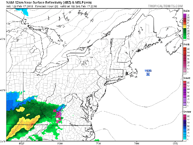
Low pressure is over the Tennessee Valley at midday, and will quickly move towards the Mid-Atlantic coastline this evening, passing south of New England as it intensifies tonight. Even though the sun is shining now, clouds will quickly move in this afternoon, with snow developing late this evening, around 9pm or so, give or take an hour. Snow will continue overnight, with the possibility for some briefly moderate to heavy snow. Since most of you will be sleeping, this shouldn’t cause too many problems. A change to rain seems likely across parts of Cape Cod and the Islands, possibly even into extreme southeastern Massachusetts.
Forecast for the progression of the storm based on the NAM model. Loops provided by Tropical Tidbits.
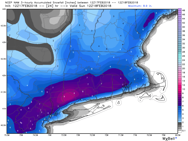
Everything winds down near or a little after daybreak. For most of us, a general 3 to 5 inches of snow is expected, with a few spots possibly seeing 6 or 7 inches. Across Cape Cod, where a change to rain is likely, amounts of 1 to 3 inches seem more plausible at this time.
The NAM model is probably closest to our thinking for snowfall totals with this storm. Image provided by WeatherBell.
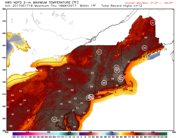
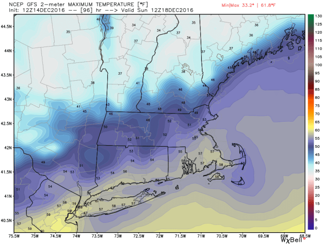
The snow won’t last too long though. The sun will return Sunday afternoon, with temperatures getting up into the 40s. That will help to quickly melt a lot of what fell overnight. Temperatures will drop back below freezing Sunday night, so things may ice up once again. Use caution if you’re heading out for anything. Even warmer weather is heading in for the start of the week. A warm front will move through on Monday, with some showers preceding the front late in the day. Once the front moves through, unseasonably warm conditions are expected for Tuesday and especially Wednesday. On Tuesday, high temperatures should get into the upper 50s and 60s away from the South Coast. On Wednesday, we could challenge some record highs, with some places possibly making a run at 70 degrees. A cold front will move through late in the day on Wednesday, bringing an end to the warm weather, so enjoy the early taste of Spring while it’s here.
Yes, temperatures could reach or exceed 70 in parts of the region on Wednesday. Image provided by Weathermodels.com
So, as you may have heard from the relentless media hype over the past few days, we’ve got a storm headed our way on Thursday. While this will be an extraordinary storm for places like Florida, Georgia, and the Carolinas, up here, we’ve seen a lot worse.
Snowfall accumulations of 2-5 inches from northern Florida into eastern North Carolina? That doesn’t happen too often. Image provided by Weathermodels.com
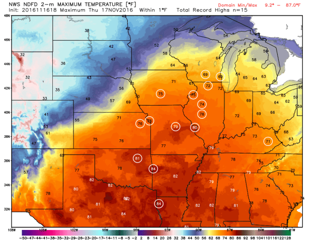
Snow and sleet have been falling today across portions of northern Florida, Georgia, and South Carolina. Several inches are expected to fall today, especially along the coastline. Given how rarely this happens in some of these locations, it will probably bring the region to a halt, while those of us in the North point and laugh. Don’t worry, our time is coming tomorrow.
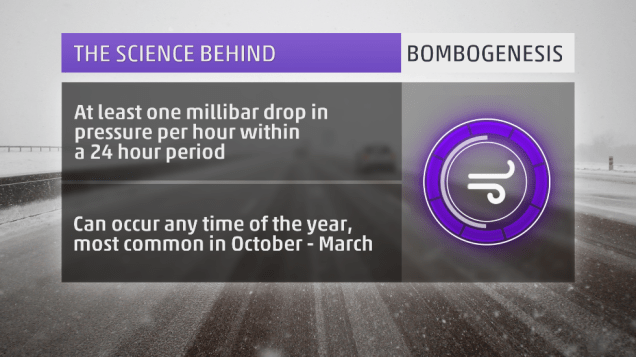
The storm that is producing the snow down South will move up the East Coast later today and Thursday, rapidly intensifying as it does so. You may have heard the terms “bombogenesis” or “weather bomb” used as part of the media hype in the last few days to describe this storm. These are terms that have been around for quite some time. Bombogenesis happens when the lowest pressure of a storm drops more than 24 millibar in a 24 hour period. This happens several times a year with storms off the East Coast. It is nothing out of the ordinary. The reason this storm is getting the attention, aside from the Southern snow, is that the pressures are much lower than a typical winter storm. This will be a strong storm system, but again, we’ve had powerful storms off the East Coast plenty of times before.
Definition of “bombogenesis”. It’s a fairly common occurrence. Image provided by Weather.com
As the storm gets cranked up off the East Coast, it will generate strong winds,, especially along the coast. While we’re looking at wind gusts to 40-50 mph, possibly even higher, things could be a lot worse. We don’t have a large high pressure system to our north (more on that in a minute). If we had a high to our north, increasing the pressure gradient between the storm and the high, winds would be even stronger. The tighter the gradient, the stronger the winds. This is why we can have strong winds with weaker systems, if there is a large high in place to the north.
Along with the winds, coastal residents also have to worry about coastal flooding. Since we’re just past the full moon, tides remain astronomically high. Add in strong onshore winds, and residents along north to northeast facing beaches could experience some coastal flooding around the midday/early afternoon high tide on Thursday. By the time we get to the high tide Thursday night, winds will have shifted into the west or northwest, thus limiting the flooding potential.
Back to the high pressure, or lack thereof, to our north. High pressure has been sitting to our north or northwest all week, which is why we’ve been frigid since before New Year’s. That high has shifted offshore now, allowing somewhat milder air to settle in today. Normally, to get heavy snow, we need that high pressure area to stay to our north or northwest, to lock the cold air into place. With that not the case this time, we’re going to have to deal with a rain/snow line. That seems hard to believe given how cold the past week has been, but it is the case. Water temperatures are still in the lower 40s off our coast, so a strong onshore wind will warm up the lowest layers of the atmosphere enough for a change to rain. This seems like across Cape Cod, but the question becomes, how far inland does that rain/snow line penetrate? The models have varying ideas on this, but a portion of southeastern Massachusetts may see a changeover.
Winter Storm Warning are in effect for virtually the entire East Coast, with Blizzard Warnings (in red) for parts of coastal New England. Image provided by NOAA.
So, we’ve talked about strong winds, coastal flooding, and a rain/snow line. Now, for the only part that most of you are interested in – snow. First, we’ll talk about the timing. Snow should develop from south to north across the region between about 3 and 6am. So, by the time most of you wake up, it will likely be snowing. The snow will end between 7 and 10pm for most of us. The worst of the storm will be between about 9am and 4pm. Snow will be moderate to heavy at times, which combined with strong winds, will create whiteout or blizzard conditions, especially along the coast. If you don’t have to be out tomorrow morning/afternoon, we’d recommend staying where you area. Blizzard warnings have been posted for parts of eastern and southeastern Massachusetts, the NH Seacoast, as well as coastal and Downeast Maine. Remember, the amount of snowfall has absolutely nothing to do with blizzard conditions. You can have a blizzard with no snow falling at all. By definition, you have a blizzard when visibility is 1/4 mile or less due to falling or blowing snow and you have sustained winds or gusts to 35 mph or more for 3 consecutive hours or more.
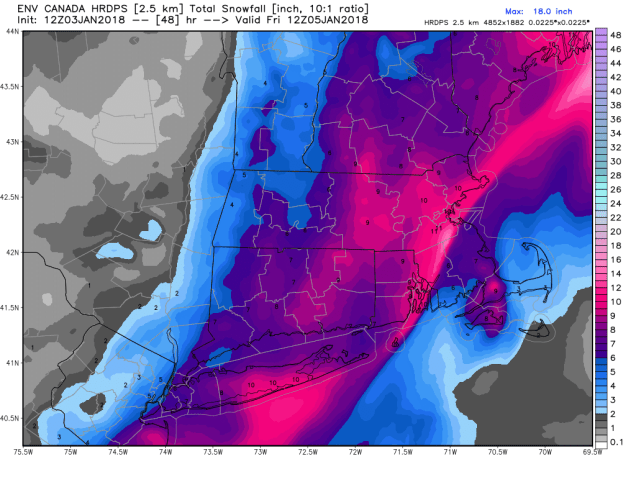
So, how much snow are we looking at? There isn’t really one model that we completely agree with, so we’re going with a blend of the ideas. Because the storm will be moving along fairly quickly, we’re not looking at any blockbuster amounts. The trickiest part is where the rain/snow line sets up. Right now, we’re thinking somewhere close to the Cape Cod Canal. As for amounts, here’s the breakdown:
Outer Cape Cod/Islands: 3-5″
Upper Cape Cod: 4-8″
Southeastern Massachusetts (south and east of I95): 8-14″
Northern RI/Interior Eastern Massachusetts/North Shore: 6-12″
Central Massachusetts/Merrimack Valley/Southern NH/Seacoast: 5-9″
The biggest wild card is Southeastern Massachusetts, especially the closer to Cape Cod you get. The farther the rain/snow line moves inland, the less accumulations will be. This is the area of biggest “bust potential”.
The Canadian HRDPS model is probably closest to our thinking, but not exactly the same. Image provided by WeatherBell.
Once the storm moves by, we’ll slowly clear out on Friday, but gusty northwest to west winds will usher another arctic blast into the region. Saturday may be even colder than any of the days we’ve had over the past week. Especially with fresh snowcover, temperatures will plunge again, with the worst of it on Saturday, when high temperatures likely stay in the single digits. Sub-zero lows are likely across much of the region Saturday morning and especially Sunday morning.
The current weather pattern across the country is one that is fairly typical of Spring. However, the results of that pattern are Winter in the Rockies and Summer in the East. In between, there is plenty of severe weather, which is fairly typical of Spring.
A ridge in the East, a trough in the West. Not that uncommon of a pattern. Image provided by College of DuPage.
An upper-level low pressure area will move out of the Pacific Northwest and into the nation’s midsection over the next few days. While one storm system moves into the Upper Midwest today, a second one will develop east of the Rockies and move into the Plains states on Thursday. With cold air moving in behind these systems, and warm, moist air flowing northward from the Gulf of Mexico ahead of them, strong to severe thunderstorms are likely again for the next few days across the Plains states.
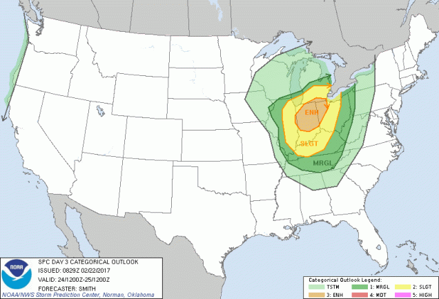
Thursday could be a very active day for severe weather in the Central and Southern Plains. Image provided by the Storm Prediction Center.
Severe weather has plagued the Plains states and Great Lakes for the past few days, with over 500 reports of severe weather between Monday and Tuesday. Nearly 30 tornadoes were reported, along with hail as large as softballs, and hundreds of reports of wind damage from gusts as high as 85 mph.
85 mph wind gust here at the office in Valley NE #newx
Behind the low pressure area, a late-season snowstorm is expected across the Rocky Mountains. Heavy snow will continue across portions of Montana and Idaho today, spreading into Wyoming and Colorado for Thursday into Friday. Across the higher elevations, totals of 1-3 feet are expected, which will keep the ski season going for a while longer. Snow may also spread into the High Plains of eastern Colorado and western Nebraska, with some minor accumulations possible. In Denver, it looks a couple of slushy inches may fall, though at least 1 model is forecasting much heavier amounts. In a normal year, Denver averages 1.7″ of snow, and the city has seen measurable snow during the month of May in 11 out of the last 16 years, so snow in May is not uncommon, though a heavy snowstorm, if it materializes, would be. Denver has only received 10 or more inches of snow in the month of May 6 times in a 135 years of records, with a record total of 15.5″ set back in May of 1898.
A late-season snowstorm may drop up to 3 feet of snow in the higher elevations of the Rockies. Image provided by WeatherBell.
Meanwhile, in the East, an early taste of summer is ongoing, thanks to a ridge of high pressure aloft, and a surface high pressure area off the East Coast. Temperatures soared into the 80s and lower 90s on Wednesday, setting several records, but the hottest day for many locations will be Thursday. High temperatures will climb into the lower to middle 90s in many locations, likely breaking records across much of the region. When you combine the heat with dewpoints well into the 60s, it will definitely feel like a mid-summer afternoon across the region. A cold front will move through the area of Friday, possibly triggering a few showers and thunderstorms, but also sending temperatures back to where they should be in the middle of May.
A lot of record high temperatures may be broken across the Northeast on Thursday. Image provided by WeatherBell.
It seems as though we went through this last week, but once again, after a taste of early Spring, Mother Nature is about to remind us that March can still bring plenty of wintry weather to the area.
Today is the transition day, as strong winds usher much colder air into the region behind a cold front that crossed the region late Wednesday night. While temperatures are still in the 40s, things are about to change, and most of you probably won’t like it. That cold front will stall out south of New England today, and low pressure will ride along it across the Mid-Atlantic states, passing south of us on Friday. Meanwhile, high pressure will build in north of New England, bringing plenty of cold air with it. Let’s see now, cold air moving in from the north and moisture moving in from the south. What happens when you combine those? That’s right, you get SNOW! Luckily, we’re not looking at a lot of snow this time. Let’s get to the details:
Snow should start to develop early in the morning, possibly even starting as a little rain across Cape Cod and southeastern Massachusetts. The snow may fall at a pretty good clip during the morning hours, tapering off and ending during the afternoon.Since we’re into mid-March, the sun angle is roughly the same as the end of September. In other words, fairly strong. So, once we get past sunrise, even though it’ll be cloudy, the snow will have a tougher time sticking to paved surfaces. That’s the good news. The bad news is that a lot of the snow will fall before then, so the roads may not be that pretty for the morning commute.
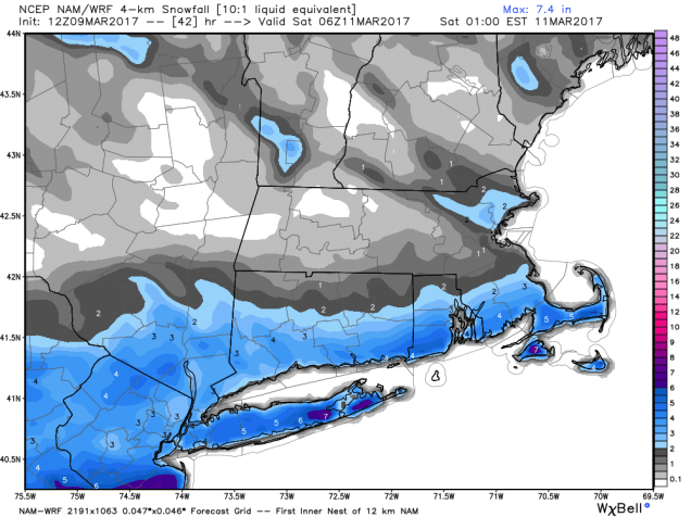
Forecast from the NAM model for the progression of Friday’s storm. Loop provided by Pivotal Weather.
OK, so the snow ends in the afternoon and we’re done right? As noted college football analyst Lee Corso used to say “Not so fast my friend”. As the storm moves into the Gulf of Maine, a piece of energy, called a Norlun trough (Explained here by Matt Noyes), may produce some additional light snow from the North Shore up into southern New Hampshire and south coastal Maine through the evening hours. It won’t amount to much, but could be just enough to screw up the evening commute well north of Boston.
So, how much snow are we looking at? North of the Mass Pike, probably less than an inch, if any snow falls at all. From the North Shore into Boston and it’s immediate southern and western suburbs, probably 1-2 inches. For the South Coast, roughly south of Route 44, 2-4 inches should do it, with a little more possible across parts of the Cape and Islands.
The High Resolution NAM model most closely matches our thinking with regards to snowfall on Friday. Image provided by WeatherBell.
All in all, not a big deal, especially by New England standards. What will be a big deal is the cold air behind the storm. Similar to last Saturday, this Saturday will be quite chilly, especially with fresh snowcover. High temperatures may struggle to get into the lower 20s, but wind chills will be in the single numbers and below zero. So, if you’re heading outside, make sure you bundle up. It’ll feel more like January than March.
Finally, we’re aware of the uncontrolled hype on the Internet (and TV) about a potentially major snowstorm on Tuesday. Right now, it’s a potential storm and nothing else. We’ll certainly keep our eyes on it, and if a threat does materialize, we’ll let you know well in advance. For now though, it’s nothing more than a figment of the computer models’ imaginations. We don’t participate in hype or speculation here at StormHQ, so we’re going to leave it at that.
The old saying is that March comes in like a lion and goes out like a lamb. We’ll see about how it goes out, but it certainly looks like it’s going to come in like a lion this year, but not in the usual way.
We’ve got some unseasonably mild air already in place, but it’s going to get even warmer as a warm front moves across the region tonight. It’ll be accompanied by some showers, and maybe even a rumble of thunder when it moves through. Some of the rain overnight may be locally heavy, but since most of you will be sleeping when it comes through, you won’t even notice. Also, with the warm front coming through, we’ll have our low temperatures this evening instead of in the morning, as temperatures will slowly rise overnight.
Plenty of record highs are expected across the Northeast on Wednesday. Image provided by WeatherBell.
This brings us to Wednesday. Once that warm front moves across the area, even warmer air will flood into the region, with highs again soaring well into the 60s. The only limiting factor for tomorrow will be cloud cover, which there will likely be plenty of. If we can get some breaks of sunshine, it wouldn’t be a surprise if temperatures made a run at 70 in spots.
Warm temperatures aren’t the only story for Wednesday though. A strong cold front will be approaching from the west. While this front will bring an end to our warmth Thursday morning, it’s what happens ahead of it that is a bigger concern.
A slight risk for severe weather exists across parts of southwestern New England on Wednesday, with a marginal risk for most of the remainder of Southern New England. Image provided by the Storm Prediction Center.
As is usually the case during the warmer months, with a warm and relatively humid airmass in place, the atmosphere will become unstable. Add in some lift ahead of the front and you get showers and thunderstorms. The bigger the clash in airmasses, but stronger the storms. That’s what will happen tomorrow. Thunderstorms will develop ahead of the front during the afternoon and evening hours and may even continue into the nighttime ahead of the front. Some of the storms could become quite strong, with heavy downpours, frequent lightning, and damaging winds. There is even the chance for an isolated tornado. Just last week, a tornado touched down in Goshen and Conway, Massachusetts – the first confirmed tornado ever during the month of February in the Commonwealth.
A severe weather outbreak is possible across the Ohio and Mississippi Valleys today. Image provided by the Storm Prediction Center.
The severe weather threat shifts eastward on Wednesday. Image provided by the Storm Prediction Center.
New England isn’t the only place where severe weather is expected though. In fact, what’s expected up here is minor compared to the Ohio and Mississippi Valleys. As that cold front moves into those areas later today into early Wednesday, widespread severe weather is expected to develop. Large hail, heavy downpours, damaging winds and several tornadoes are expected. This is more typical of April than the last day of February.
After this front moves offshore, things quiet down a bit, and we get back into weather that is more typical of early March, especially here in the Northeast. We do need to keep an eye on Friday though. An Alberta Clipper will be diving southeastward from the Great Lakes. It will pass south of New England during the day on Friday and into Friday morning. While the majority of the forecast models keep the system far enough south of have little to no impact on us, not all of them do. So, there is the chance for some light snow, especially south of the Mass Pike, on Friday. We’ll have more on this later in the week if the threat materializes.
“In the Spring, I have counted 136 different kinds of weather inside of 24 hours.” – Mark Twain
It’s not quite spring yet, but this quote is still appropriate. Much of the nation’s midsection has been enjoying temperatures more typical of April than February for the past week, with a few hundred record high temperatures broken. That is about to change, as Mother Nature will remind the region that is still February.
Numerous record highs are expected across the Plains and Midwest again today. Image provided by WeatherBell.
Of course, they will still have one more warm day today, with highs well into the 60s and 70s likely setting more records. However, a cold front will sweep across the region, bringing an end to the record heat, and setting the stage for a snowstorm.
The low pressure system that brought more rain to California over the past couple of days will head eastward, bringing some snow into the Rockies today. As that system moves into the Plains on Thursday it will start to strengthen, drawing moisture northward from the Gulf of Mexico while cold air flows southward on the backside of the storm into the Northern Plains. Where these airmasses meet, snow will develop across the Central Plains states. The snow will be accompanied by winds of 20-30 mph, gusting to 40 mph or more at times, resulting in near-blizzard conditions across portions of South Dakota, Nebraska, southeastern Wyoming, and eastern Colorado on Thursday.
More than a foot of snow may fall in a swath from the Plains into the Upper Midwest. A lot of these same places are going to be in the 60s and 70s today. Image provided by Pivotal Weather.
As the system heads eastward, snow will move into portions of the Mississippi Valley and the Upper Midwest on Friday. The heaviest snow looks to stay just south of the Twin Cities, but even there, moderate to heavy snow is likely. By the time the storm moves out on Saturday, a foot or more of snow is possible in a swath from the Central Plains into the Great Lakes.
Snow isn’t the only threat from this system. As the storm moves eastward, record warmth will remain in place across the Midwest. With warm, moist air in place and a strong cold front approaching from the West, strong to severe thunderstorms are possible across portions of the Lower Great Lakes and Ohio Valley on Friday. Some of the stronger storms that form may contain damaging winds, hail, and possibly tornadoes.
The Storm Prediction Center has already highlighted the Midwest as an area to watch for severe weather on Friday. Image provided by NOAA.
The system will continue to move eastward, bringing some rain to the East Coast on Saturday, which may cause problems for hockey fans in the Steel City. The next NHL Stadium Series game (Ed – Enough with the outdoor games already. It jumped the shark a long time ago), is scheduled for Saturday at 8pm between the Pittsburgh Penguins and Philadelphia Flyers. The daytime hours will likely be mild with rain, but the rain may change to snow late in the day as temperatures tumble. Either way, it won’t be a pleasant night for fans to be sitting in the stands at Heinz Field. Here at Storm HQ, we despise the Flyers, so we hope their fans not only have to sit through the weather, but watch their team get thumped too.
That’s former UMass-Lowell RiverHawk (and StormHQ favorite) Scott Wilson hoisting the Stanley Cup last June. Image provided by Toronto Star.
Once it gets past Pittsburgh, that front will head eastward, bringing some rain to us here in New England. It probably won’t be a lot of rain, but temperatures will be in the 50s and possibly 60s ahead of the front on Saturday. Once the front comes through, Sunday will be windy and colder.
“Get in, sit down, shut up, and hold on” – Toby Keith
Ladies and gentlemen, please make sure your safety belts are securely fastened, as this rollercoaster is ready to go. Yup, the weather will go through several changes over the next few days, giving us a little of everything – howling winds, bitterly cold wind chills, snow squalls, sleet, freezing rain, heavy rain, unseasonably mild temperatures. And that’s just before the weekend is over.
We’ll start with Thursday. A series of arctic cold fronts will cross the region. Some snow squalls may accompany the fronts, so you’ll need to be prepared for that if you’re out and about during the day. These are the winter equivalent of summer thunderstorms. They’re impossible to predict ahead of time, usually don’t last too long, but can have severe impacts if you get caught in one. Visibility can drop to near zero in an instant, a quick inch or two of snow could accumulate, and the next town over could see nothing at all.
Very strong winds are likely Thursday night behind the cold front. Might be a good idea to bring some of those Christmas decorations inside for a few days. Image provided by National Weather Service – Taunton.
While the snow squalls can be a high-impact but localized event, the strong winds and bitterly cold temperatures will be felt region-wide. Northwest winds of 15-30 mph are likely, with gusts upwards of 50-60 mph possible, especially Thursday afternoon into Friday morning. High Wind Watches have been posted for parts of the region. If you have any loose objects outside, such as trash barrels, Christmas decorations, small children, etc, you may want to consider bringing them inside, so that they don’t blow away.
GFS model forecast for low temperatures across the region Friday morning. Yes, those are in Fahrenheit, not Celsius. Image provided by WeatherBell.
These gusty winds will also usher some of the coldest air so far this winter into the region. Most days, the day starts off cool, warms up until mid-afternoon, then cools off again as the sun goes down. Thursday will not be one of those days. We’ll start the day with temperatures in the 30s, but temperatures will drop into the 20s by midday, then keep dropping. By Friday morning, most places will see temperatures in the single numbers, with some sub-zero readings possible. When you factor in the wind, the wind chill will be 15 to 25 below zero in many areas. Make sure you’re all bundled up if you have to head outside for any reason at all. Better yet, stay inside, it’s easier.
Wind chills of 15 to 25 degrees below zero are expected Friday morning, Bundle up if you have to head outside for anything. Image provided by Pivotal Weather.
The good news is, the cold air will be short-lived. The bad news is, the transition from the arctic air will be rather messy. A storm system will head up the St. Lawrence Valley this weekend. Precipitation will develop ahead of this system before sunrise Saturday morning. That precipitation will start as snow, but as warmer air moves in aloft, it will start to change over. How quick that changeover occurs is the big question mark.
GFS model forecast for the progression of a storm system across the Northeast this weekend. Loop provided by Tropical Tidbits.
Cold air will likely remain entrenched at the surface, especially away from the coastline. With warm air moving in aloft, that means we’ll likely see a changeover to sleet and/or freezing rain across the interior Saturday afternoon. Along the coast, a quick change to rain is likely, as water temperatures remain in the 40s, which will help warm things up fairly quickly near the shoreline. Eventually, that warmer air will move in at the surface across the entire area, with a change to plain rain expected overnight. Before that changeover happens, we’ll probably see snowfall accumulations of 1-3″ south and east of I-95, including the Boston and Providence metropolitan areas. North and west of I-95, we’re looking at 2-5″ of snow, with the possibility of some sleet or ice accretion. Please keep this in mind if you have plans in this region Saturday afternoon/evening.
Temperatures will be quite mild when you wake up Sunday morning, but more changes are coming. Image provided by WeatherBell.
OK, so it warms up Saturday night and everything changes to rain. End of story, right? Nope, the ride isn’t over yet. By Sunday morning, temperatures will be in the 40s to lower 50s north and west of Boston, with 50s and possibly even some 60s from Boston southward. So, Sunday will be a nice warm day, right? Nope. Temperatures will peak in the morning, then drop again throughout the day as the system drags a strong cold front across the region. In fact, if the rain is slow to depart, it could change back over to some snow or sleet before ending in the afternoon. It probably won’t accumulate, but with wet roads and sharply falling temperatures, we could see some black ice develop on many area roadways. Again, just one more thing to keep in mind in you are heading out and about late Sunday afternoon or evening.
Things start to calm down after that. Monday will be quite chilly again, with highs only in the 20s, and gusty winds keeping wind chills close to zero. Temperatures start to moderate next week, and a late-week system could bring in some rain. Right now, it’s not looking like a White Christmas, but things can still change. Beyond that? Well, the GFS model gave us a good laugh this afternoon.
The GFS model is having delusions this afternoon. Sure, it’s a possibility, but we’re not putting much stock in this forecast. It is fun to look at though. Image provided by Tropical Tidbits.
Just in time for Thanksgiving, it looks like all the ingredients are in place for Mother Nature to cook up a Plains Blizzard.
To say that November has been warm across the nation would be a BIG understatement. Image provided by WeatherBell.
A storm system will move out of the Rockies and across the Plains states over the next few days. Ahead of the system, warm, moist air will be drawn northward from the Gulf of Mexico. High temperatures on Thursday will be in the 70s as far north as Chicago and Des Moines, with record high temperatures expected across much of the Mississippi Valley. The warmth won’t last too much longer though, as a strong cold front will be marching eastward across the Great Plains.
Numerous record high temperatures are expected on Thursday across the Mississippi Valley. Image provided by WeatherBell.
Behind the front, much cooler air will settle southward from Canada. With plenty of moisture being drawn northward, it will fall as snow on the backside of the low from the Central Rockies and Central Plains northeastward into the Upper Midwest. Some of the snow could be heavy, especially in parts of South Dakota and Minnesota, where snowfall totals of 10-15 inches are expected by Saturday evening, with some heavier amounts possible. As you might expect, Winter Storm Watches have been posted from eastern Wyoming and northern Nebraska northeastward to Minnesota.
Snowfall forecast through Saturday evening from the GFS model. Image provided by Pivotal Weather.
Snow isn’t the only hazard with this system. As it strengthens, it will create strong winds across much of the Plains states. Sustained winds of 20-30 mph with gusts to 50 mph or more are expected, especially from the Dakotas into Nebraska. The combination of high winds and snow may result in blizzard conditions at times. A blizzard watch has been issued for southwestern Minnesota, northeastern South Dakota, and extreme southeastern North Dakota.
Yup, that’s a Blizzard Watch for parts of Minnesota and the Dakotas. Image provided by NOAA.
Once the system moves into southern Canada this weekend, some of the coldest air so far this season will settle into the region. While these temperatures aren’t that unusual for late November, they will be quite a change from the recent warmth that has enveloped the area. Low temperatures will likely drop into the teens and 20s across the region this weekend, with single digits possible. In some of the locations with fresh snowcover some sub-zero readings are possible. The cool air will be short-lived, as temperatures will likely warm back up to above normal readings by early next week. Current indications are that the unseasonably mild weather will persist for the most part well into December across the region.
As the system heads up into Canada, it will drag a strong cold front across our region on Sunday. Enjoy the mild air for the next few days, because things will change by late Sunday. In fact, on Monday, with temperatures expected to stay in the upper 30s and 40s at best, and some precipitation around thanks to an upper-level low pressure area, we could see some wet snowflakes falling. We’re not expecting any accumulation right now, because the ground is still much too warm, but we’re not going to rule out seeing snow showers at this point.
October can be a time of change in the Northeast. While the first thing that comes to mind is the changing colors of the foliage across the region, the weather also changes, sometimes quite frequently. That’s what we’re going to be dealing with for the next few days.
Current temperatures across the Northeast as of 1pm on October 19. Image provided by WeatherBell.
It’s an unseasonably warm afternoon across much of the Northeast, with temperatures generally in the 60s and 70s, with 80s from southern Connecticut into the Mid-Atlantic states. Dozens of record highs have been set over the past few days, and more are falling today. However, some changes are coming, and the warm weather will be a distant memory within the next 24-48 hours.
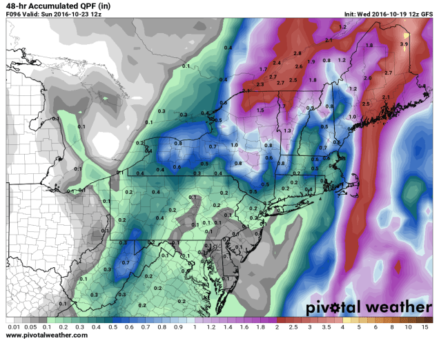
A cold front is moving across the region this afternoon, though you really couldn’t tell, as there’s only scattered cloud cover and little precipitation with the front. That front will stall out to the south of New England tonight. On Thursday, a wave of low pressure will start to approach from the west. This will spread rain and showers into the region. Some of the rain will be heavy, especially from New York into Pennsylvania late Thursday into Friday. With rainfall totals of 1-3 inches and locally up to 5 inches expected, some flooding is likely. Across New England, where a serious drought is ongoing, rainfall will be much lighter, with most locations likely receiving under half an inch of rain.
Expected rainfall through Friday evening across the Northeast. Image provided by Pivotal Weather.
As that wave of low pressure moves into Upstate New York on Friday, it will lift that cold front back across New England as a warm front. While Friday won’t be as warm as today, temperatures will still get into the 60s and lower 70s across much of New England. With dewpoints also in the 60s, it will be a rather muggy day for mid-October.
Computer model forecasts for the track of a tropical disturbance in the Bahamas. Image provided by Tropical Tidbits.
Meanwhile, there is a tropical disturbance brewing in the Bahamas right now. While conditions are favorable for development, we’re not looking at another monster like Matthew, it could become a tropical depression or subtropical storm over the next few days. The system will likely head northward, moving towards the Gulf of Maine as we head into the weekend. This will bring another round of heavy rainfall into Maine and Atlantic Canada, again missing most of Southern New England, where the rain is most needed.
Expected rainfall between Friday morning and Sunday morning across the Northeast. Image provided by Pivotal Weather.
Once the system moves into southeastern Canada, it is expected to stall out under an upper-level low pressure area and become a strong extratropical system. It will drag a cold front across the Northeast, bringing much colder air into the region. With strong low pressure nearby and much colder air filtering in, rain will change over to snow across portions of Upstate New York and Northern New England. While the snow will be confined mainly to the higher elevations, this is the first accumulating snow of the season across the area. Several inches may accumulate across parts of the Adirondacks and the Green Mountains.
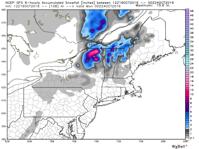
Expected snowfall through Sunday evening across the Northeast. Image provided by WeatherBell.
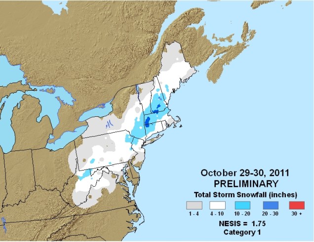
While there could be a few wet flakes mixed in with some of the rain across lower elevations of Central New England, accumulating snow is not expected.Sunday will be a chilly day, with highs only in the 40s and 50s across much of the Northeast. These readings are 10-20 degrees below normal. Of course, any mention of snow in October across the Northeast will make residents think back just a few years to the pre-Halloween snowstorm that dropped 1-2 feet of snow across parts of the region, setting numerous records. While this system won’t come anywhere close to that, it should make for some spectacular photos of snow-capped mountains and valleys filled with colorful foliage early next week.
Snowfall from the Halloween snowstorm of 2011. Image provided by NOAA.
Rush wrote that lyric for the song “Time Stand Still”, and it’s pretty obvious they were talking about September. No matter how you define it, summer is either just about over, or already is. Astronomical fall begins on September 22 at 10:21am EDT, but meteorological fall is defined as the period between September 1 through November 30. For some people, summer ends of Labor Day or when football starts up. No matter your definition, we’re at that time of year. While it can and does still feel like summer across parts of the nation, there are more and more signs that summer is winding down.
As the nights start to grow a little longer the farther north you go, the cooler air starts to build up a little more, especially as you head into Canada and Alaska. The cold fronts that drop down from Canada and into the Northern US start to pack a little more punch. One of those fronts is moving across portions of the Upper Midwest and the Great Plains today. The airmass moving into the Rockies and Northern Plains behind the front is sending temperatures as much as 15 to 25 degrees below normal this afternoon.
Temperatures are 15-25 degrees below normal in the Northern Rockies and Northern Plains today. Image provided by Pivotal Weather.
As that airmass settles in, low temperatures will drop into the 30s and 40s across the Northern Plains and Rockies tonight. Frost advisories and freeze warnings have been posted for western portions of North Dakota for Tuesday morning. By Wednesday morning, the coldest air will move over Minnesota, where low temperatures could drop into the upper 20s and 30s. Additional frost and freeze advisories will likely be issued for this region.
A taste of things to come soon. GFS model forecast for low temperatures across Minnesota Wednesday morning. Image provided by WeatherBell.
Cold temperatures aren’t the only noteworthy item with this cold front. As the cold air surges into the Rockies, precipitation will accompany it. That precipitation will likely fall as snow in many areas, mainly at elevations above 5000 feet. Across some of the higher peaks, more than a foot of snow could accumulate over the next day or two. Winter Weather Advisories have been issued for portions of northern Wyoming as a result.
GFS model forecast for snowfall through Wednesday morning. Image provided by WeatherBell.
Some snow is also possible across the higher elevations of the Sierra Nevada as the cooler air spreads into the West. While accumulations will be minor, this will likely be the first snowfall of the year for this region. Across the rest of the Golden State, temperatures will likely be 6 to 12 degrees below normal on Tuesday, with highs only in the 70s to lower 80s, a welcome change from the 90s and 100s they’ve had for most of the summer.
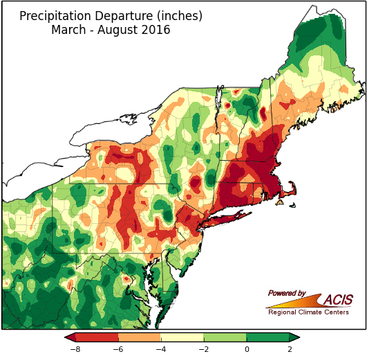
While this front will bring cooler air into our area later this week, one thing it won’t do unfortunately, is bring beneficial rainfall to the region. It will produce showers and some thunderstorms, and while a few of the storms may contain heavy downpours, they’ll be very localized. Across much of the region, rainfall totals will be generally under half an inch. This will do little to put a dent in the severe drought that much of the region is currently experiencing. Rainfall deficits of 5 to 10 inches below normal since the beginning of March are common across the region.We really need some rain, and there doesn’t look to be a lot of it on the horizon.
Rainfall deficits across the Northeast from March 1 through August 31. Image provided by the Northeast Regional Climate Center.
While this early taste of fall moving into much of the Northern US this week is not uncommon for mid-September, it might not be repeated much this fall. Long-range forecasts are showing the likelihood of a warmer than normal fall across much of the United States.