Weekly Outlook: October 18-24, 2021

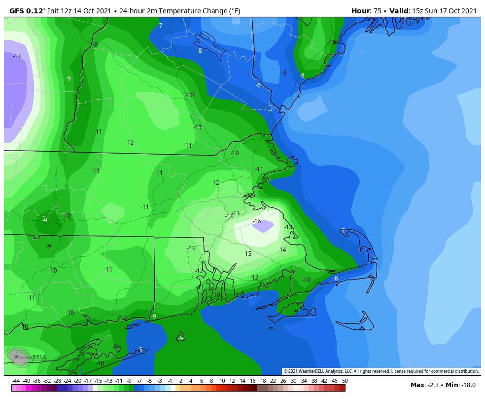
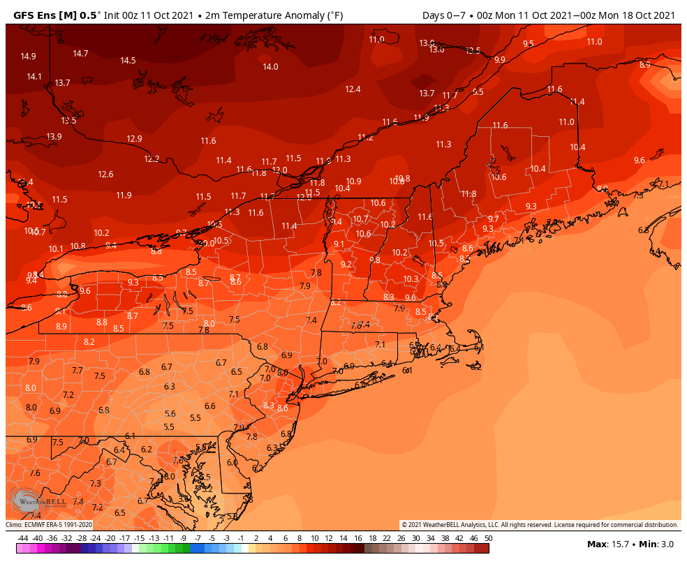
Cooler weather has finally arrived, and it will be here for part of the upcoming week.

A chilly night is expected across the region tonight. Image provided by WeatherBell.

High pressure continues to build into the region today with temperatures running a few degrees cooler than we had on Sunday. With an upper-level disturbance still moving through, we’ll see clouds develop, and a few pop-up showers are possible in the afternoon. High pressure remains in control on Tuesday with dry and seasonably cool conditions. By Wednesday, the high moves offshore, and a southwest flow will bring milder air back into the area. Thursday also looks warm, but clouds will be on the increase as a cold front approaches from the west. That front will move through Thursday night or early Friday with a few showers, but the bigger story is what happens behind the front. Friday’s temperatures will be determined by when the front moves through, but for now at least, it looks mild again, at least to start.

Thursday should be quite a mild day. Image provided by Weathermodels.com

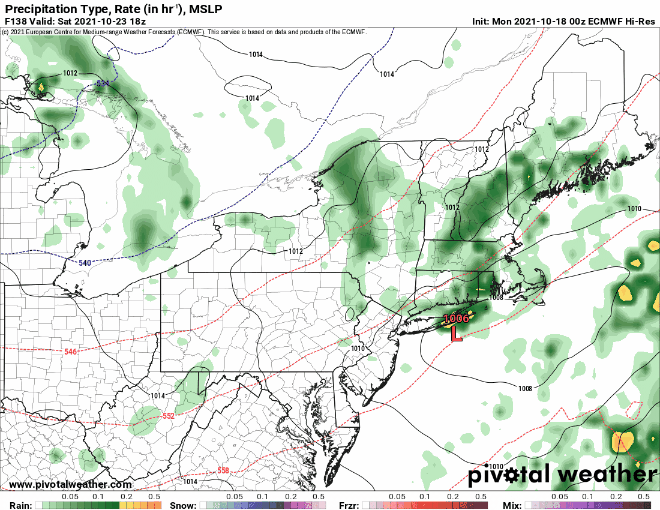
Even cooler air settles into the region next weekend. Temperatures likely won’t get out of the 50s on Sunday, with many places likely dropping into the 30s at night. Before you complain too much, some of the models show the potential for lake-effect snow in parts of western and northern New York next weekend. We’ve also got to keep an eye on a low pressure system that may try and move up the coast on Saturday, but for now at least, it looks like it should stay offshore.

We’re keeping an eye on a potential system for Saturday. Images provided by Pivotal Weather.

Monday: A mix of sun and clouds, breezy, chance for a pop-up shower or two. High 54-61.

Monday night: Partly cloudy and quite cool. Low 38-45.

Tuesday: Sunshine and a few clouds, breezy again. High 56-63.

Tuesday night: Clear to partly cloudy. Low 44-51.

Wednesday: Partly sunny and milder. High 65-72.

Thursday: Sunshine gradually fades behind thickening clouds, showers may develop overnight. High 66-73.

Friday: Intervals of clouds and sunshine, chance for some showers early. High 63-70.

Saturday: Partly sunny, chance for a shower. High 54-61.

Sunday: A mix of sun and clouds, breezy. High 52-59.

Weekend Outlook: October 15-18, 2021

Fall is the season of change, and changes are coming this weekend in terms of the weather.

High pressure remains in control into Friday with another warm day expected under partly sunny skies. However, a strong cold front is marching eastward, and it will arrive on Saturday. Ahead of it, a warm front will move through Friday night, perhaps accompanied by a few showers. Saturday will be breezy and warm, but we’ll have plenty of clouds, with showers developing by late afternoon. Showers and some thunderstorms are likely through the evening, but should end before daybreak Sunday as the cold front finally crosses the region. Behind the front, breezy and much cooler conditions are likely for Sunday and Monday. While it will feel almost chilly at times, these temperatures will be right around normal for mid-October. Both Sunday and Monday will feature some sunshine, but with an upper-level disturbance moving through, we’ll have clouds developing, and just a slight chance for a shower each afternoon.

Temperatures at midday Sunday will be 10-15 degrees cooler than at midday Saturday. Image provided by WeatherBell.

Thursday night: Partly to mostly cloudy. Low 53-60.

Friday: Intervals of clouds and sun. High 68-75, possibly a little cooler along the coast.

Friday night: Plenty of clouds, chance for a few showers. Low 57-64.

Saturday: A few sunny breaks, mainly early, but generally cloudy and breezy with showers possible late in the day. High 69-76.

Saturday night: Scattered showers, possibly some thunder as well. Low 49-56.

Sunday: Any lingering showers end early, otherwise a mix of sun and clouds, breezy, slight chance for an afternoon shower. High 60-67.

Sunday night: Clear to partly cloudy. Low 42-49.

Monday: Partly sunny, chance for an afternoon shower. High 54-61.

Weekly Outlook: October 11-17, 2021

All the signs are there that we’re well into fall – the leaves are changing colors, baseball’s playoffs are in full swing, football is well into the season, hockey starts up this week, basketball next week, pumpkin flavored everything has invaded everywhere, but someone forgot to give Mother Nature the memo, as we’ve got some warm weather on the way for much of the week.

Normal high temperatures for mid-October are in the lower to middle 60s. Image provided by Weathermodels.com

We start the week off with high pressure to the north and low pressure well south of New England. The low may produce a few showers near the South Coast this morning, but high pressure should eventually win out, with some sunshine developing during the afternoon. Even more sunshine and milder temperatures are expected on Tuesday as the high continues to build in. A weak system moves through on Wednesday with little fanfare except for some clouds and just a slight chance for a shower. High pressure returns for Thursday and Friday with dry and warm conditions.

Temperatures will average 6-10 degrees above normal across the region this week. Image provided by WeatherBell.

Next weekend is where things get a little uncertain. A cold front will be approaching the region, and it’s timing is still a bit of a question mark. Saturday looks quite mild at this point, but as the front draws nearer, some showers and possibly thunderstorms are likely ahead of it. Much of the day should remain dry, with showers holding off until nightfall, but this is far from certain. The front likely moves through at night, with much cooler air settling in on Sunday. However, if the front doesn’t move through until sometime Sunday, as at least one model shows, then Sunday could start off quite warm before temperatures drop during the afternoon. We should have better clarification of the timing of the front for our Weekend Outlook on Thursday.

The timing of next weekend’s system is still in question. Images provided by Pivotal Weather.

Monday: A few showers near the South Coast early, otherwise plenty of clouds with some sunny breaks. High 64-71.

Monday night: Becoming partly cloudy. Low 49-56.

Tuesday: Partly sunny. High 68-75.

Tuesday night: Clear to partly cloudy. Low 50-57.

Wednesday: Partly sunny, slight chance for a shower. High 69-76.

Thursday: Partly sunny. High 69-76.

Friday: Becoming partly to mostly cloudy. High 69-76.

Saturday: A mix of sun and clouds, showers and possibly some thunderstorms likely at night, breezy. High 68-75.

Sunday: Showers end early, then becoming partly to mostly sunny, breezy, and cooler. High 61-68.

Weekend Outlook: October 8-11, 2021

Columbus Day Weekend has arrived, but it still won’t feel quite like fall just yet for the entire weekend.

High pressure remains in control through the 1st part of Friday with dry and mild conditions, but a backdoor cold front will drop down the coast, bringing cooler weather in for Friday night and Saturday. There may even be some drizzle or a few showers around at times too. High pressure builds back in for Sunday, but we’ll have to keep an eye on low pressure south of New England. There is still some question as to whether the rainfall from this system makes it into our area Sunday night and Monday. We’ll include the chance for showers in the forecast for now, but the most likely spot for any rain will be along the South Coast.

Most of the models aren’t terribly enthusiastic about the rain chances for Sunday night and Monday. Images provided by Pivotal Weather.

Thursday night: Clear skies. Low 48-55.

Friday: Sunshine gives way to increasing afternoon clouds. High 66-73.

Friday night: Mostly cloudy with some patchy drizzle or a few showers. Low 47-54.

Saturday: Clouds and a few sunny breaks, some spotty drizzle or a shower are still possible. High 59-66.

Saturday night: Mostly cloudy. Low 47-54.

Sunday: Plenty of clouds. High 61-68.

Sunday night: Partly to mostly cloudy with a chance of showers, mainly near the South Coast. Low 50-57.

Monday: More clouds than sun, showers are possible again, mainly near the South Coast. High 66-73.

Weekly Outlook: October 4-10, 2021

A wet start to the week, then we dry out. Wet weather may return for the end of the week.

A frontal system is stalled out across the region, and waves of low pressure will ride along it, bringing in rain, some of it heavy, Monday and Monday night, with showers tapering off on Tuesday. High pressure builds in for Wednesday through Friday, with dry and gradually milder weather. Next weekend is a bit uncertain, as high pressure will remain to the north while low pressure tries to move up from the south. We’ll see which feature wins out.

Most of the models agree on a general 1-2 inches of rain by the end of the day Tuesday, with some showing heavier amounts. Images provided by Pivotal Weather.

Monday: Cloudy with periods of rain and showers, some of which may be heavy. High 56-63.

Monday night: Cloudy with more rain and showers. Low 51-58.

Tuesday: Cloudy with a few showers. High 58-65.

Tuesday night: Becoming partly cloudy. Low 48-55.

Wednesday: Partly sunny and milder. High 63-70.

Thursday: Mostly sunny. High 68-75.

Friday: Partly to mostly sunny. High 66-73.

Saturday: More clouds than sun, cooler. High 61-68.

Sunday: Mostly cloudy with a chance for showers. High 63-70.

Editorial note: Thursday’s Weekend Outlook is normally published during the mid-to-late afternoon. This week, it will likely not be published until sometime Thursday night, so you’ll probably be able to read it Friday morning.

Weekend Outlook: October 1-4, 2021

Most of the upcoming weekend should be pretty good weatherwise, but probably not all of it.

An upper-level low pressure area will pull away tonight, but a few showers are still possible through the first part of the night, mainly near the coastline. High pressure builds in for Friday into Saturday with drier conditions. While Friday should feature a decent amount of sunshine, Saturday will likely have more clouds as a weak system passes by to the north. Could it produce a few showers? Maybe, but mainly in southern New Hampshire.

Friday morning will be on the chilly side. Image provided by WeatherBell.

Sunday is when things get really tricky. A low pressure area will be slowly moving in from the west, sending a warm front toward the region. The question is, how far north does the warm front get before stalling out? This will have a large impact on temperatures. Our best estimate at this point is that it will at least get up to the Mass Pike, but beyond that, we’re not sure. South of the warm front, it will be warm and humid, with temperatures likely getting into the 70s. North of the front it may stay in the upper 50s and lower 60s. The next question is – when does the rain move in? Right now, it looks like we may have some showers late Sunday afternoon and evening ahead of the warm front, but that isn’t set in stone at this point. Late Sunday night into Monday do look wetter, but again, this is far from a lock.

Sunday’s temperatures will be determined by how far north the warm front gets. Images provided by Pivotal Weather.

Thursday night: Mostly cloudy with a few showers possible this evening, then skies clear out overnight. Low 40-47.

Friday: Sunshine and some afternoon clouds. High 60-67.

Friday night: Partly to mostly cloudy. Low 43-50.

Saturday: More clouds than sun, slight chance for a sprinkle across southern New Hampshire. High 65-72.

Saturday night: Partly to mostly cloudy, slight chance for a shower, mainly across southern New Hampshire. Low 50-57.

Sunday: Mostly cloudy, chance for a few late-day showers. High 59-66 north of the Mass Pike, 67-74 south of the Pike.

Sunday night: Mostly cloudy with showers developing. Low 53-60.

Monday: Mostly cloudy with scattered showers. High 62-69.

Weekly Outlook: September 27 – October 3, 2021

Baseball’s regular season is in the home stretch, football is well underway, hockey is starting up, and pumpkin everything is showing up everywhere. It’s definitely fall now. Mother Nature is going to get in on the act this week too. Goodbye shorts, hello light jackets or sweatshirts.

It’s been a warm September, but changes are coming as we near the end of the month. Image provided by the Northeast Regional Climate Center.

The week starts off on a warm note with high pressure still in control, but changes are coming. A cold front dropping southward will produce some showers tonight and Tuesday, with a rumble of thunder possible as well. High pressure builds in behind the front on Wednesday with cooler and drier conditions. A wave of low pressure will ride along the front to our south Wednesday night and Thursday, with another period of showers likely. Friday looks like a typical fall day to start October. An upper-level low pressure are will be moving across the region, bringing with it some clouds and possibly a few showers. High pressure should return for the weekend with dry and cool conditions.

High temperatures may struggle to reach 60 on Thursday. Image provided by WeatherBell.

Monday: Partly sunny. High 70-77.

Monday night: Mostly cloudy with a chance for a shower. Low 57-64.

Tuesday: Plenty of clouds with showers likely, possibly a rumble of thunder. High 68-75.

Tuesday night: Partly to mostly cloudy, any lingering showers end in the evening. Low 46-53.

Wednesday: A mix of sun and clouds. High 61-68.

Thursday: Mostly cloudy with some showers possible. High 57-64.

Friday: Early sun, then clouds return, slight chance for an afternoon shower. High 60-67.

Saturday: Plenty of sunshine. High 61-68.

Sunday: A mix of sun and clouds. High 62-69.

Weekend Outlook: September 24-27, 2021

Some rain is on the way, but much of the weekend looks decent weatherwise.

A slow-moving cold front will make its way across the region tonight and Friday, bringing plenty of clouds in, with some rain likely, mainly on Friday. A few rumbles of thunder are also possible. We’re not expecting a widespread heavy rain like we had at times for most of the summer, but don’t expect to see much, if any, sunshine on Friday. The front pushes offshore Friday night, but showers may linger into Saturday morning across eastern Massachusetts. While there may be some sunshine developing, especially well west of Boston, during Saturday afternoon, clouds will linger in the east. Another wave of low pressure will ride up that front offshore, but will likely pass close enough to bring some rain back in for Saturday night and Sunday morning. This is a relatively new development in the models, but it shows up on several models, so we’re inclined to go with it. We should start to clear out again on Sunday, but an upper-level feature will be moving across the region, and it may kick off another shower or two during the afternoon. High pressure builds in for Sunday night and Monday with drier conditions.

Most of the heavy rain will be confined to western New England. Image provided by Weathermodels.com

In the tropics, Tropical Storm Sam has developed over 1700 miles east of the Lesser Antilles. It is sat least 5 days away from potentially threatening any land areas, but Sam will definitely be a storm to watch. Most of the models develop Sam into a powerful hurricane over the weekend and early next week. Sam should continue on a west-northwest track across the Atlantic through the weekend. Beyond that? It’s still way too early to speculate on where Sam may go.

Forecast track for Tropical Storm Sam. Image provided by the National Hurricane Center.

Thursday night: Partly to mostly cloudy with a few showers possible. Low 64-71.

Friday: Cloudy with scattered showers, possibly a thunderstorm. High 71-78.

Friday night: Mostly cloudy, showers ending from west to east. Low 55-62, a little milder across Southeastern Massachusetts and Cape Cod.

Saturday: Intervals of clouds and sun, chance for a few showers, mainly in eastern Massachusetts. High 68-75.

Saturday night: Mostly cloudy with more showers possible. Low 53-60.

Sunday: Any lingering showers end early, then becoming partly sunny with a chance for a late-day shower. High 68-75.

Sunday night: Clear to partly cloudy. Low 49-56.

Monday: A mix of sun and clouds. High 67-74.

Weekly Outlook: September 20-26, 2021

“Summer’s going fast, nights growing colder”

That line from the Rush song “Time Stand Still” is talking about the next couple of days. Summer officially ends with the autumnal equinox at 3:20pm on Wednesday.

We start the week off with high pressure in control, providing us with sunshine and seasonably mild temperatures. As the high moves offshore on Wednesday, southerly winds will bring warmer and more humid air into the region. There may be enough moisture around to trigger a shower or two across the interior, but for the most part, the day will remain dry.

Tuesday morning could be a little chilly across the interior. Image provided by WeatherBell.

The end of the week is where things get tricky. A slow-moving frontal system will head this way, but the models don’t agree on the timing of the system. One model has the system bring us a rainy day on Thursday, with the showers ending early Friday. A couple of others have just a few showers on Thursday, with the bulk of the rain moving in on Friday and lingering into part of Saturday as the front really slows down. Given the trends recently, we’re going to lean toward the slower timing for now. This will impact Sunday’s forecast as well, as another system will be following, and if the first system takes longer to move out, then then second system will take longer to move in. We should have some more clarity on this for our Weekend Outlook on Thursday.

The models don’t agree on the timing, but they all show a pretty decent amount of rainfall for the end of the week. Images provided by Pivotal Weather.

Monday: Sunshine and a few afternoon clouds. High 68-75.

Monday night: Clear to partly cloudy. Low 48-55.

Tuesday: A mix of sun and clouds. High 67-74.

Tuesday night: Partly to mostly cloudy. Low 55-62.

Wednesday: Partly sunny, chance for a few showers, mainly across the interior. High 71-78.

Thursday: Intervals of clouds and sun, a few showers are possible, mainly across the interior again. High 72-79.

Friday: Mostly cloudy and breezy with showers likely, possibly some steady rain at night. High 70-77.

Saturday: Showers end by early afternoon, some sunny breaks may develop in the afternoon, especially across the interior. High 68-75.

Sunday: Partly to mostly sunny. High 67-74.

Weekend Outlook: September 17-20, 2021

Improving weather is coming, but it will take a little while to get here this weekend.

A frontal system will wash out along the South Coast tonight and Friday while high pressure tries to build in. The result will be mainly dry conditions, but still plenty of cloud cover, especially along the South Coast. Temperatures will remain on the cool side compared to the last few days thanks to northeast to east winds, but we should still see most places get into the 70s.

Skies are clearing out not far to our north and west, Meanwhile, low pressure is trying t organize off the Carolina coast. Loop provided by NOAA.

Meanwhile, an area of low pressure off the Carolina coast is trying to organize this afternoon and it could become a tropical depression or even a weak tropical storm over the next day or so. It will move northward and then northeastward, passing well south and east of us Friday night and Saturday. However, it will bring some gusty northeast winds to coastal areas, and churn up the seas again, resulting in some rough surf and rip currents at the beaches.

Forecast tracks for the disturbance off the Carolina coast from the various members of the GFS Ensemble. Image provided by Weathernerds.org

A weak cold front will also be moving in on Saturday, with a few showers possibly accompanying it. For later Saturday into Sunday and Monday, we’ll have high pressure building in, which means sunshine and mild temperatures, which is about as good as it gets for the final weekend of astronomical summer. Fall begins with the autumnal equinox at 3:20pm next Wednesday.

Average high temperatures in mid-September are in the lower to middle 70s around here. Image provided by Weathermodels.com

Thursday night: Mostly cloudy, chance for a few showers across the South Coast and Cape Cod. Low 58-65.

Friday: Partly to mostly cloudy. High 70-77.

Friday night: Partly to mostly cloudy. Low 60-67.

Saturday: A mix of sun and clouds, slight chance for a shower, mainly well north and west of Boston. High 72-79.

Saturday night: Mostly clear. Low 57-64.

Sunday: Plenty of sunshine. High 69-76.

Sunday night: Clear skies. Low 50-57.

Monday: Unlimited sunshine (daylight hours only). High 71-78.