Half of the upcoming weekend looks decent weather-wise, but that means that half the weekend won’t be so nice.
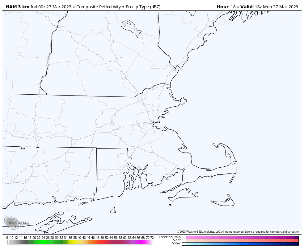
A warm front will approach the region today, with clouds streaming in, and rain developing by late afternoon. The rain may start as some sleet or wet snow across the hills of central Massachusetts and southwestern New Hampshire, but even there, a change to rain is expected with little accumulation. Temperatures rise behind the front at night, and the rain comes to an end, but as second round of rainfall is likely on Saturday in the warm air. Don’t be shocked if some thunderstorms develop as well as a cold front approaches. The front moves through in the evening then high pressure builds in for Sunday with sunshine and chilly conditions once again. As the high moves offshore, temperatures will moderate on Monday.
Around 1 inch of rain is expected late Friday and Saturday across the region. Image provided by WeatherBell.
Thursday night: Clear skies, clouds start to filter in late at night. Low 22-29.
Friday: Becoming cloudy and breezy with showers developing in the afternoon, possibly some sleet or wet snow in the hills. High 44-51.
Friday night: Cloudy and breezy with rain tapering off in the evening, showers redevelop late at night. Low 37-44 during the evening, temperatures will start to rise overnight.
Saturday: Partly to mostly cloudy and windy with rain likely, possibly a thunderstorm. High 57-64, cooler along the South Coast.
Saturday night: Mostly cloudy and breezy with showers ending in the evening, some clearing late at night. Low 31-38.
Sunday: Plenty of sunshine, windy, and cooler. High 41-48.
The week won’t be completely quiet, but dry weather is expected for Red Sox Opening Day on Thursday.
The week starts off with high pressure moving offshore, allowing for a dry day today, but clouds will be on the increase ahead of a weak storm system. That system will pass south of the region tonight, with some rain showers likely, possibly mixed with a little snow, especially across the hills and into southern New Hampshire and the Merrimack Valley. Skies will be slow to clear out on Tuesday behind the system with an upper-level disturbance moving through, possibly producing another shower or two. High pressure builds in for Tuesday night and Wednesday with clearing skies and seasonable temperatures. A cold front moves through Wednesday night or early Thursday with a few rain or snow showers likely.
Tonight’s system should be mostly rain, but some wet snow is possible. Loop provided by WeatherBell.
For Red Sox Opening Day on Thursday, skies should become partly to mostly sunny, but it will be on the breezy and cool side. For first pitch a little after 2pm, it will only be around 42 degrees, but when you factor in the northwest winds at 10-20 mph gusting to 30 mph, it will feel like it’s only in the lower to middle 30s.
It may not feel like baseball weather on Thursday, but it’s another sign that Spring has arrived.
Friday will turn warmer as winds shift into the southwest, but clouds will be on the increase again ahead of the next storm system. The details are still a little fuzzy on this one, but for now, it looks like we’ll have periods of rain at some point between Friday night and Sunday, though it could start and/or end as snow across southern New Hampshire and the Worcester Hills. As for temperatures, the models all show a warm front moving in, but how far north it gets is up for debate. South of the front, temperatures could climb into the 60s, north of it, they may stay in the 40s (or 30s). We should have more clarity when it’s time for our Weekend outlook on Thursday.
The models vary by 20-30 degrees on temperatures for Saturday afternoon. Images provided by Pivotal Weather.
Monday: Morning sunshine, increasing and thickening clouds in the afternoon, showers develop late in the day. High 50-57.
Monday night: Cloudy with some light rain and showers likely, possibly mixed with wet snow before ending. Low 31-38.
Tuesday: Clouds and some afternoon sunny breaks, a shower or two is possible. High 41-48.
Tuesday night: Partly cloudy. Low 26-33.
Wednesday: Sunshine and a few clouds, chance for a rain or snow shower at night. High 46-53.
Thursday: Mostly sunny and breezy. High 40-47.
Friday: Mostly cloudy and breezy, showers developing at night. High 45-52.
Saturday: Mostly cloudy and windy with rain likely. High 59-66, potentially much cooler north of the Mass Pike.
Sunday: Early showers, then becoming partly sunny and breezy. High 43-50.
We’ve got some unsettled weather coming our way for the next few days.
Some showers are likely through the evening before a cold front crosses the region overnight. We’ll see some clearing on Friday as high pressure tries to build in, but with the front stalled out just to the south, some clouds will linger, especially near the South Coast. Gusty winds behind the front will usher some cooler air in. Friday night will be on the chilly side with lighter winds and clear skies allowing for radiational cooling. Clouds quickly return on Saturday ahead of another storm system. While this one will be mainly rain, it may start as some snow, especially north and west of I-495. Some slushy accumulations are possible, but a change to rain will wash them away by late in the day. Rain comes to an end Sunday morning, then high pressure builds in for the rest of Sunday and Monday with dry and seasonable conditions.
Most of the models show precipitation beginning as a wintry mix outside of I-495 Saturday afternoon. Images provided by Pivotal Weather.
Thursday night: Partly to mostly cloudy with showers ending before midnight, breezy. Low 35-42.
Friday: Partly sunny, breezy in the morning. High 47-54.
Friday night: Partly cloudy. Low 27-34.
Saturday: Mostly cloudy and breezy with showers developing, starting as some wet snow outside of I-495 before changing to rain. High 39-46.
Saturday night: Mostly cloudy and breezy, with rain likely. Low 32-39 during the evening, temperatures may rise a bit overnight.
Sunday: Showers end early, then becoming mostly sunny, windy. High 51-58.
Sunday night: Clear skies, breezy. Low 30-37.
Monday: Sunshine and a few clouds, still breezy. High 46-53.
Spring begins today, and we’ve got some nice weather for a few days, but the latter half of the week may not be as nice.
Tuesday is the pick of the week with sunshine and temperatures possibly making a run at 60. Image provided by WeatherBell.
High pressure will be in control through Wednesday with dry weather and a warming trend expected. It’ll still be breezy today, but winds should diminish into Tuesday. Clouds will start to increase on Wednesday ahead of a warm front. That front will produce some showers Wednesday night into early Thursday, setting up a very mild day, with some showers possible. The front will sag southward as a cold front late in the day, likely stalling out near or just south of New England. Another wave of low pressure rides along that front on Friday with some additional showers likely, depending on where the front stalls out. With some cooler air in place, we could see some wet snow mix in across northern Massachusetts and southern New Hampshire if the front does stay out near the South Coast, but these are the types of details that are kind of fuzzy this far out, and will need to be fine-tuned later this week. Another low pressure likely moves up the St. Lawrence Valley over the weekend with a secondary low pressure system passing south of New England, but the details regarding timing and precipitation type with this system vary depending on which model you look at.
Saturday may not be a great day around here. Images provided by Pivotal Weather.
Monday: Wall-to-wall sunshine, breezy. High 45-52.
Monday night: Clear to partly cloudy. Low 25-32.
Tuesday: A mix of sun and clouds, breezy during the afternoon. High 53-60.
Tuesday night: Partly cloudy. Low 29-36.
Wednesday: Some morning sun, then becoming mostly cloudy with showers possible at night. High 51-58, cooler at the coast.
Thursday: Cloudy and breezy with a few showers early, then becoming more numerous late in the day and into the evening. High 52-59.
Friday: Cloudy, more showers possible, breezy. High 48-55.
Saturday: Cloudy and breezy with a chance of rain or possibly snow, especially north and west of Boston. High 40-47.
Sunday: More clouds than sun with a chance for showers early, breezy. High 44-51.
The final weekend of astronomical winter will be a fairly quiet one across the region.
Astronomical Spring begins with the Vernal Equinox at 5:24pm Monday. Image provided by EarthSky.org
Clouds start to stream into the region tonight ahead of a warm front. A few showers are likely on Friday as the front moves across the region,, but it will be quickly followed by a cold front early Saturday, which may produce a few more showers. We’ll clear out behind the cold front on Saturday, but the colder air will take its time moving in, so we’ll have another mild day, which shouldn’t interfere with any St. Patrick’s Day celebrations. High pressure settles in for latter half the weekend with dry and cooler weather on Sunday, but temperatures will start to moderate for Monday.
Normal high temperatures for mid-March are generally in the middle 40s for our area. Image provided by Weathermodels.com
Thursday night: Partly cloudy through the evening, clouds increase after midnight. Low 27-34.
Friday: Mostly cloudy and becoming breezy with a few late-day showers. High 47-54.
Friday night: Mostly cloudy, chance for a few showers, mainly during the evening. Low 33-40.
Saturday: A few showers early, then becoming partly sunny, breezy. High 46-53.
Saturday night: Clear to partly cloudy, breezy. Low 22-29.
Sunday: A mix of sun and clouds, windy, and cooler. High 34-41.
Sunday night: Clear skies, breezy. Low 20-27.
Monday: Plenty of sunshine, breezy again. High 42-49.
As Metallica sings in the beginning of the song “All Nightmare Long”, luck does indeed run out. After getting lucky for nearly the entire winter without a major snowstorm, it appears that our luck has finally run out.
Today will be the literal calm before the storm with high pressure sliding off to the east, but still keep us dry despite plenty of cloudcover. After that, we turn our eyes to a developing low pressure system moving up the East Coast. This will likely be a potent storm when it gets up here, producing strong winds and quite a bit of precipitation. It’s also expected to stall out and perhaps make a bit of a loop, which means we’re looking at a long-duration storm, starting this evening, and likely not ending until Wednesday morning. That’s what we’re fairly certain about. What we’re not certain about is the actually track the storm takes, and where it stalls/makes a loop, and that is the most critical part of the forecast. Temperatures will be marginal to begin with, so a degree or two will make a huge difference. We’re not worried about any warm air aloft, so sleet and freezing rain aren’t a concern – just a good old-fashioned rain/snow line. With marginal temperatures, intensity will also help determine what falls, as lighter precipitation will be more rain than snow, while heavier precipitation will bring some colder air down from aloft, resulting in more snow than rain.
Whether it’s rain or melted snow, this will be a rather juicy storm. Image provided by WeatherBell.
OK, having said all that, he’s our best estimate as to what we expect – low pressure moves up the East Coast, passing just south and east of Cape Cod. Meanwhile, a much weaker secondary low will move across Long Island and southern Connecticut, before it weakens and dissipates. This will help keep temperatures a little warmer, especially near the South Coast, with east to southeast winds. The original rather potent system will then do a loop in the waters just east of New England, before finally moving away on Wednesday. In terms of sensible weather we’re probably looking at nearly all snow north of the Mass Pike and outside of I-495, especially in the hills. South and east of there, precipitation likely starts as rain this evening, gradually changing to snow from northwest to southeast during the day on Tuesday as the system moves off to the east, and strong north to northwest winds bring cooler air in. Those winds will gust to 40-50 mph at times, but luckily tides are astronomically low, so coastal flooding isn’t a widespread concern.
We think the forecast track on the NAM is close to what might happen. Loop provided by Tropical Tidbits.
As for snowfall, we need to make a distinction here between snowfall and snow accumulation. With the increasing sun angle, and the warmer ground, snow will have a hard time accumulating during the daylight hours, especially on paved surfaces, when precipitation is falling lightly. So, it could snow for quite some time, but there won’t be much on the ground. The model forecast maps that people love to share on Facebook and Twitter show snowfall, and as we’ve just said, those maps will not be reflective of what you may see on the ground when this storm winds down. What are we expecting for accumulation?
0-2″ – Outer Cape/Islands 2-4″ – South Coast/Upper Cape/Coastal Plymouth County 4-7″ – I-95 corridor (Providence/Boston), southeastern Massachusetts/North Shore 5-9″ – Metro West/Essex County/NH Seacoast 6-12″ – Merrimack Valley/Southern New Hampshire 8-16″ – Hilly terrain from northwest Rhode Island into central Massachusetts and southwest New Hampshire with isolated heavier amounts possible.
We will note that there are some models that do bring heavier (in some cases MUCH heavier) snow into eastern and especially southeastern Massachusetts. We’re not putting much stock in those. However, if they do end up correct, our snowfall forecast will be off by several orders of magnitude.
Our forecast isn’t that different from what the National Weather Service is forecasting. Image provided by Weathermodels.com
Once this storm pulls away, high pressure builds in with drier and more seasonable conditions for Wednesday night and Thursday. Another system may move in later Friday into Saturday, but this looks like mainly rain, with drier weather again behind that storm on Sunday.
Monday: Mostly cloudy, breezy, showers developing late in the day. High 40-47.
Monday night: Windy with rain likely, changing to snow across southern New Hampshire and central Massachusetts toward daybreak, rain may be heavy at times. Low 32-39.
Tuesday: Windy with rain changing to snow from northwest to southeast during the day. Snow and rain could be heavy at times. High 33-40 early, temperatures hold steady or drop during the day.
Tuesday night: Windy with snow gradually tapering off. Low 27-34.
Wednesday: Mostly cloudy and windy, snow showers ending. High 33-40.
Thursday: A mix of sun and clouds, breezy. High 42-49.
Friday: Becoming mostly cloudy, breezy, showers develop at night. High 45-52.
Saturday: Mostly cloudy, breezy, showers likely, possibly changing to snow before ending at night. High 45-52.
What looked like a complicated forecast earlier this week looks a lot easier now for much of the weekend. Things get a lot more complicated later Monday though.
High pressure will continue to build in tonight and Friday, with generally dry and seasonably cool conditions continuing. A storm system will pass west and then south of the region Friday night and Saturday. The cloud shield from the system will overspread the region late Friday, but most of the snow (or rain) will likely stay to our south and west. Yes, some snow showers may move in Saturday morning (mixed with rain near the South Coast), but accumulations, if any, will be negligible, except toward the Worcester Hills and the hills of northern Rhode Island, but even there, less than an inch is expected. High pressure builds back in for Saturday night and Sunday with chilly conditions once again. Monday is where things get interesting.
Very little snow is expected across our area on Saturday. Image provided by WeatherBell.
Low pressure will start to move up the coast on Monday, spreading more clouds in, but beyond that, there is considerable uncertainty in the track of the storm. Some models keep it mostly south and east of us, some bring it right up over us. No matter what the track, they all forecast the storm to become fairly strong, and hang around, so the effects of the storm will continue into much of Tuesday. So, at a minimum, we’ll have some gusty winds, and possibly a little coastal flooding, though tides will not be at their astronomical high for the month. As for precipitation, well, that depends on the track. The closer the storm gets, the more likely we’ll see some rain, though snow is possible at the start and the end. The farther inland you get, the more likely you’ll see snow, and possibly some heavy snow. Some of the models are forecasting rather significant snow totals well north and west of Boston, but again, this will be highly dependent on the track. We should have a lot more clarity on this when we publish our Weekly Outlook early Monday morning.
The models do not agree on the placement or strength of our potential storm early next week. Images provided by Pivotal Weather.
Thursday night: Partly cloudy. Low 23-30.
Friday: Sunny in the morning, clouds move back in during the afternoon. High 43-50.
Friday night: Cloudy with a few snow showers, possibly mixed with rain near the South Coast. Low 26-33.
Saturday: Mostly cloudy and breezy with some snow or rain showers early. High 35-42.
Saturday night: Clearing. Low 24-31.
Sunday: Morning sunshine fades behind increasing afternoon clouds. High 39-46.
Sunday night: Mostly cloudy. Low 25-32.
Monday: Mostly cloudy, breezy, snow or rain possible late in the day. High 40-47.
Much of the upcoming week will feature quiet weather, a welcome change from the active pattern we’d had over the past few weeks.
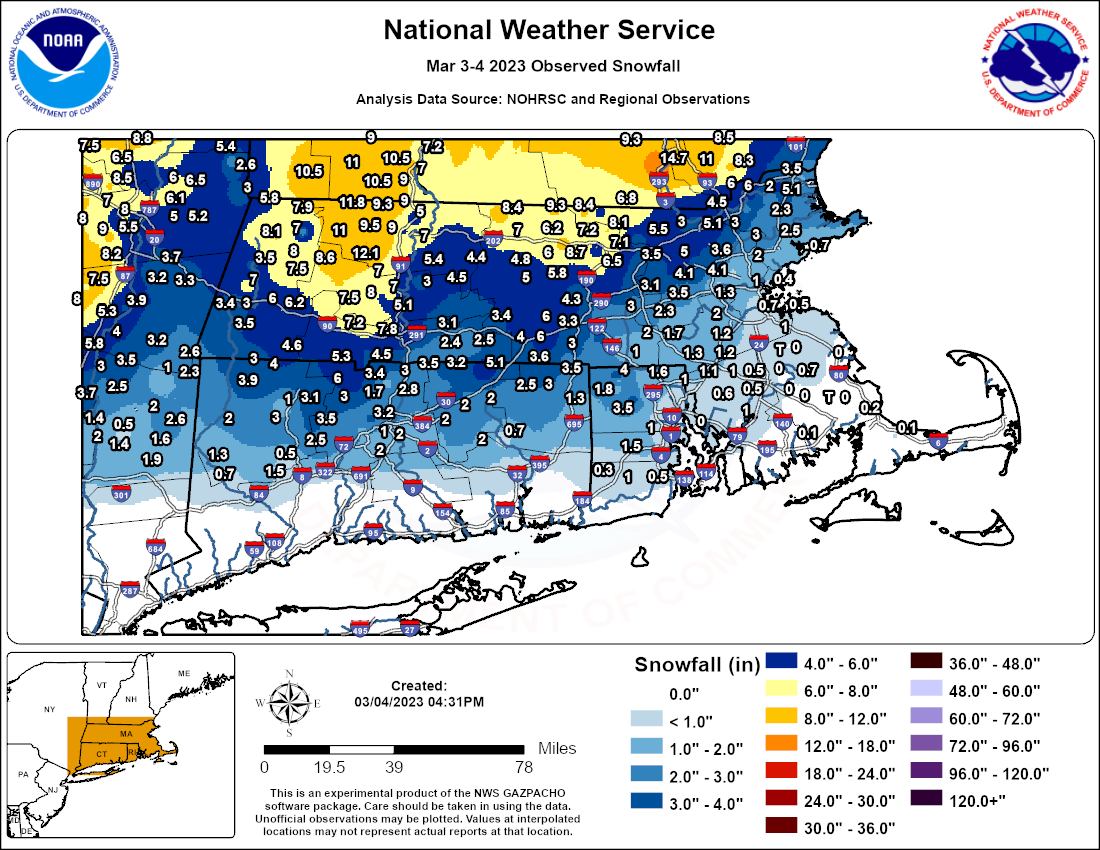
Saturday’s storm produced light to moderate snow across much of the area. Image provided by the National Weather Service.
The week starts off with high pressure providing us sunshine and seasonable temperatures, but low pressure will continue to intensify in Atlantic Canada, producing gusty winds across the region for the next few days. A weak system will move out of the Great Lakes on Tuesday, likely passing south and west of the region, but it may be close enough for a few rain or snow showers. Wednesday and Thursday will feature intervals of clouds and sunshine with a few rain or snow showers along with gusty winds as disturbances rotate around low pressure south of Nova Scotia. By Friday, high pressure builds in with more sunshine and lighter winds.
Normal high temperatures for early March are in the lower to middle 40s. Image provided by Weathermodels.com
Unfortunately, next weekend does not look as quiet. Most of the models are showing the potential for a storm system to impact the region next weekend, but they differ considerably on the details, including timing, placement, strength, and precipitation type. Hopefully, things will become clearer later this week.
The models all have different ideas for what will happen next Saturday, Images provided by Pivotal Weather.
Monday: Sunshine and some afternoon clouds, windy. High 41-48.
Monday night: Partly cloudy, breezy. Low 22-29.
Tuesday: Becoming partly to mostly cloudy, breezy, chance for a rain or snow shower. High 32-39.
Tuesday night: Partly cloudy, breezy. Low 22-29.
Wednesday: More clouds than sun, breezy, a rain or snow shower possible, mainly across Cape Cod. High 39-46.
Thursday: Partly to mostly cloudy, breezy, chance for a rain or snow shower, mainly near the coast. High 39-46.
Friday: Mostly sunny. High 40-47.
Saturday: Mostly cloudy, breezy, chance for snow or rain. High 38-45.
Sunday: Mostly cloudy, windy, chance for snow or rain. High 36-43.
Also, a remainder that Daylight Saving Time begins next Sunday at 2am, so you’ll lose an hour or sleep, or if you’ll be at work, you’ll have an hour less of work.
Meteorological spring began yesterday, so naturally, we’ve got a snowstorm on the way for a good chunk of the region.
High pressure builds in tonight with some clearing, but it won’t last too long. Couds quickly move back in on Friday as another storm system moves toward the region. This one will be somewhat similar to the last couple where the main storm system crosses the Great Lakes and heads up the St. Lawrence Valley while a secondary storm develops near the Mid-Atlantic coast and heads offshore south of New England. We’ll see snow developing Friday evening, quickly changing to rain near the South Coast and Cape Cod. Snow will continue overnight, but some warmer air will try to move in aloft, which will likely result in some sleet or rain mixing in. How far north that mixing occurs will obviously have a significant impact on the amount of snow that accumulates. Right now, our best thinking is that the mixing makes it to at least the Mass Pike, possibly up into the Merrimack Valley, during the morning and early afternoon on Saturday. The storm will also produce some gusty easterly winds, which will bring milder air in off the Atlantic, so a change to plain rain is possible near the coastline. By later Saturday afternoon, the system south of New England will pass off to the east, and winds will shift into the northeast and north, bringing cooler air back in, and allowing the precipitation to change back to all snow. While most of the steady snow should wind down towards evening, occasional snow showers may continue through the overnight as what’s left of the original low moves across the region. High pressure then builds in for later Sunday into Monday with dry and seasonably cool conditions.
Another double-barreled low will cross the region this weekend. Loop provided by Tropical Tidbits.
So, how much snow are we expecting?
Cape Cod: 1″ or less South Coast: 1-2″ Southeastern MA/Central+Northern RI: 2-4″ Boston/MetroWest/Notre Shore: 3-6″ Merrimack Valley/NH Seacoast: 4-8″ Southern/Central NH: 5-10″ with isolated amounts in excess of 12″
The amount of sleet and/or rain that mixes in will impact snowfall amounts. Image provided by WeatherBell.
Thursday night: Becoming clear to partly cloudy. Low 23-30.
Friday: Some morning sun, then clouds increase. High 37-44.
Friday night: Snow developing, changing to rain South Coast and Cape Cod, mixing with some sleet and/or rain across southeastern MA and RI overnight, becoming windy. Low 27-34.
Saturday: Windy with snow, mixing with or changing to sleet and/or rain south of the Merrimack Valley, changing back to snow late in the day. High 34-41.
Saturday night: Cloudy and breezy with occasional snow showers. Low 22-29.
Sunday: Morning clouds, some afternoon clearing, breezy. High 36-43.
Sunday night: Clear to partly cloudy. Low 24-31.
Monday: Partly to mostly sunny, breezy. High 40-47.