“It’s beginning to look a lot like Christmas”
Sure, there’s some snow on the ground in southern New Hampshire, but it won’t last too long, and the rest of us have bare ground. However, there is a chance we could have a White Christmas for parts of the region, depending on a potential storm system next weekend.

We’re starting the week on a chilly note, in the wake of the system to moved through Saturday night. We’ll turn a little milder on Tuesday as high pressure slides eastward but another weak cold front will move through. How weak? Aside from a few clouds, you’ll barely notice it, except for the fact that it’ll turn a little cooler once again. A low pressure system will pass south and east of the region on Wednesday while a second one passes well to the north. The southern system may spread some light rain into parts of eastern Massachusetts, while the northern one has little impact other than some clouds. Some of the models show the possibility of the rain spreading farther inland, where some colder air could be in place. This would imply the potential for a little freezing rain from southern New Hampshire into parts of central Massachusetts. We’re not confident that will be the case, but do acknowledge that it is possible. High pressure builds in with drier and colder conditions on Thursday.
At this point, we feel compelled to remind you that the forecast models have really struggle beyond 2-3 days lately. So, the forecast for Christmas Weekend is highly uncertain, and you should treat it that way.
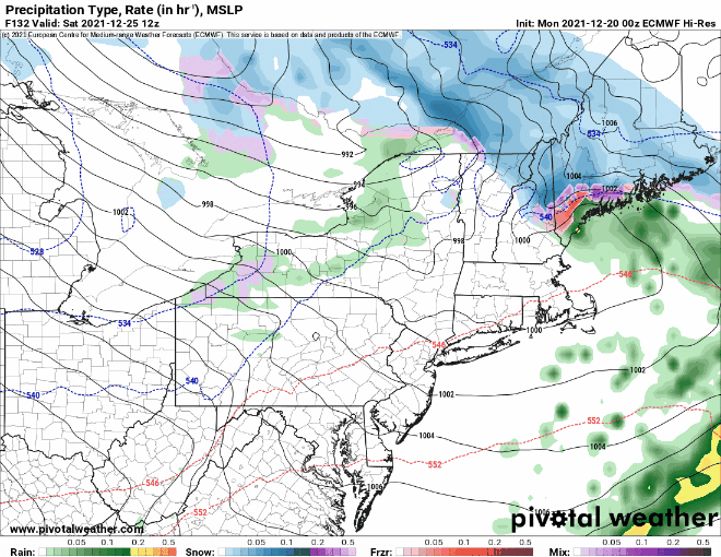
A weak disturbance may cross the region on Christmas Eve with some snow showers possible. Christmas Day is very uncertain at this point. Low pressure will head across the Great Lakes and into southern Canada, sending a warm front this way. The question is, does a secondary area of low pressure form along this front, and if so, where does it track, and also, how strong does it get? At this point, a scenario similar to the one we just had on Saturday seems plausible, with snow changing to a wintry mix and possibly rain inland, and rain possibly starting as some snow along the coast. Of course, this is all subject to change and some fine-tuning as we go through the next several days. An upper-level low will follow for Sunday, keeping some clouds and possibly a few lingering snow showers around.
Monday: Partly to mostly sunny. High 30-37.
Monday night: Partly cloudy. Low 21-28.
Tuesday: Sunshine through some high clouds. High 37-44.
Tuesday night: Mostly cloudy. Low 20-27.
Wednesday: Plenty of clouds, some light rain is possible in eastern Massachusetts, possibly a little freezing rain across the interior. High 35-42, except 43-50 across Cape Cod and parts of southeastern Massachusetts.
Thursday: Sunshine and some afternoon clouds. High 30-37.
Friday: Cloudy with some snow showers possible. High 36-43.
Saturday: Cloudy with a chance of rain or snow. High 39-46.
Sunday: Intervals of clouds and sun, breezy, chance for a few snow showers. High 35-42.
