Here at Storm HQ, we like to separate fact from fiction, or more appropriately, hype from reality. So, we’re going to do that once again in regards to a few topics involving this week’s weather.
Claim: 2020 is now the most active Hurricane Season on record.
Reality: Nope, it isn’t. Not yet at least. With the formation of now-Tropical Storm Zeta a few days ago, many people, including many that should know better, were quick to proclaim that 2020 had now tied 2005 as the busiest Atlantic Hurricane Season ever, since the last named storm in 2005 was also Zeta. However, many people didn’t bother to review that 2005 season. Every year, when the season ends (officially: November 30), the folks down at the National Hurricane Center do a review of everything, to see if there were any storms that they missed. It turns out, that in 2005, there was an unnamed subtropical storm that was added after the fact. So, 2005 ended up with 28 storms of tropical storm strength, and 2020 only has 27 such storms so far.
As for Zeta itself, after making landfall in the Yucatan just south of Cancun last night with maximum sustained winds near 80 mph, it has weakened to a tropical storm. However, as of midday, the center was moving into the Gulf of Mexico, and it is expected to re-intensify into a hurricane later today. While Zeta is currently heading northwestward, a turn more toward the north and eventually northeast is expected over the next 24-36 hours, as a trough of low pressure in the nation’s midsection pulls the storm in. Unfortunately, that means that Zeta will likely make landfall as a hurricane late Wednesday afternoon or evening along the central Gulf Coast. The current forecast has landfall in southeastern Louisiana, but anywhere from western Louisiana to the Florida Panhandle should keep an eye on Zeta’s progress. Strong winds, storm surge, and flooding from heavy rain are all threats with this storm.

Claim: An historic arctic outbreak is impacting much of the Rockies and Plains.
Reality: This one is definitely true. It’s been brutally cold out there for the past few days, with many records not only being broken, but being annihilated, and in some cases, these records have stood for over 100 years. In Bozeman, Montana, the low temperature Monday morning was 20 below zero. The record low for the day was 11 above zero, set back in 2002. When a record low is broken by 31 degrees, that’s historic. The low of -20 also shattered that city’s record low for the month of October, which was -14. Again, beating a monthly record by 6 degrees doesn’t happen that often. A little farther to the south is the town of Lyman, Wyoming. Lyman was the nation’s cold spot on Monday, when the low temperature bottomed out at 31 degrees below zero. That’s the actual temperature, not the wind chill. This is the earliest in the season that anywhere in the Lower 48 states has ever dropped to 30 below or colder, breaking a record set on October 29, 1917. With all of this cold air in place, and a storm system in the Desert Southwest, snow and ice have been common from the Southern Rockies into the Southern Plains and parts of Texas. This storm system and the cold air will move eastward over the next few days, but the air should moderate significantly.

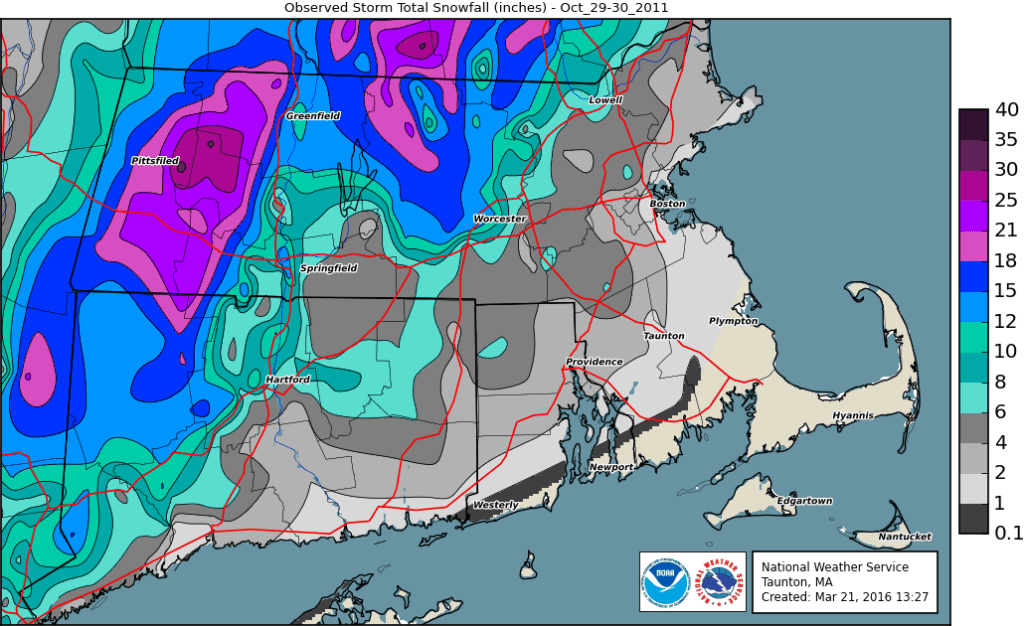
Claim: Snow in Southern New England in October means that Winter won’t feature much snow.
Reality: As with most things involving winter in New England, this one varies. Most people believe this to be true because after the big pre-Halloween snowstorm (“Snowtober”) in 2011, we didn’t get much snow through the rest of the winter. Something similar happened in 1979, when we received measurable snow on October 9-10, then little to no snow through most of the winter. The problem is, those aren’t the only times it’s ever snowed in October around here. Using data for Lowell, snow has been recorded in October during 18 of the past 91 years. During those 18 years, Lowell has averaged 53″ of snow, compared to a “normal” winter, when Lowell averages 55.8″ of snow. Of these 18 winters, all of them except for 1979-80, 2001-02, and 2011-12 featured at least one month between November and April with above normal snow. (1979 and 2011 both had above normal snow in October). Of the remaining 15, 12 of them had at least two months with above normal snow. Of the 18 overall, 13 of them featured above normal snowfall in either December, January, or both months. So, if we see some flakes on Friday, it does not automatically mean that we won’t see much this winter. (Sorry!)
Claim: The first snowstorm of the winter is expected on Friday.
Reality: Unless you live in the hills of Worcester County or in southwestern New Hampshire, this is probably not true. We talked about this in our Weekly Outlook yesterday – the pattern for the end of the week is complex, but things are looking a little clearer today. What’s left of Zeta will pass south of the region on Thursday, bringing some much-needed rain into the area. However, it looks like the bulk of the heavy rain may stay south of New England. Right behind it will be the system that is producing wintry weather across the Southern Plains. That system will pass to our south Thursday night and early Friday. As colder air gets drawn southward behind Zeta’s remnants, and the moisture from the second storm moves in, we’ll likely see the rain mix with or change over to sleet and snow across the hills of Worcester County and into the Monadnocks of southern New Hampshire. In these spots, we could see some minor accumulations, possibly a few inches. For the rest of us from southern New Hampshire into eastern Massachusetts, some sleet or snow will likely mix with the rain before it ends Friday afternoon. While there could be some slushy accumulations on grassy surfaces in southern New Hampshire and the Merrimack Valley, this is far from definite and certainly isn’t a “snowstorm”, despite any hype from the local media. Plus, as we mentioned at the start of this paragraph, it isn’t even that uncommon. It happens on average once every five years in Lowell, and the last time that it happened was – five years ago, in 2015.
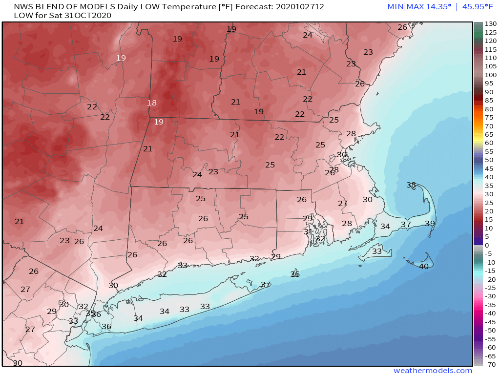
Once that storm moves away, some of the modified arctic air will move in, resulting in the coldest night of the season thus far. Temperatures will drop into the 20s across much of the area Saturday morning, resulting in a killing freeze in many places that have not yet had one. So, if you still have any plants outside that need to be brought in, now is the time. Despite sunshine, temperatures will only reach the 40s Saturday afternoon. For any kids that are trick-or-treating during the late afternoon or evening, temperatures will only be in the upper 30s to middle 40s, so make sure they are dressed properly for the weather.
