As September ends and October begins, we’ve got some changes coming for our weather pattern.
We start the week off with warm and humid conditions that feel more like late summer than early fall. Thanks to high pressure off the East Coast, southerly flow will continue to pump warm and humid air into the region today and Tuesday. However, we’ll also have plenty of clouds, along with a few showers today and again on Tuesday as a couple of weak disturbances move across the region.

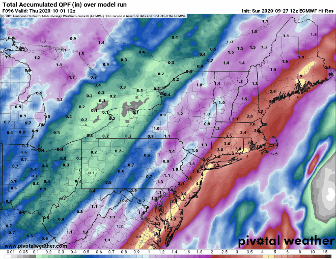
Tuesday night into Wednesday is when the bigger changes start to happen. A cold front approaches the region Tuesday night, moving through on Wednesday. A low pressure area will ride along this front, bringing in some showers. While the bulk of the activity, especially the heavy rain, looks like it will stay to our west, we will see some beneficial rain here, mainly Tuesday night into Wednesday morning. We may get a bit of a lull Wednesday afternoon and evening, but by Wednesday night, a low pressure area will move off the Mid-Atlantic coastline and head northeastward, passing near or just east of the Cape and Islands early Thursday.
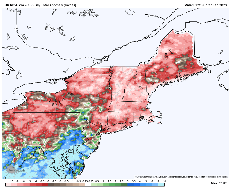
Some models are showing the potential for heavy rain across eastern New England with this system, but we’re a bit skeptical at this point. We’ve seen the models forecast significant rainfall around here numerous times in the past few months, and it just hasn’t materialized for the most part. Add in the fact that not all the models are showing the heavier rain getting in here, and the fact that even the ones that do haven’t been consistently showing it on every run, and we’ve got plenty of reasons to doubt it. Having said that, droughts don’t last forever, and it does have to start raining more consistently at some point, because this is New England, not Arizona.
High pressure will try to build in for the end of the week and the weekend with cooler and drier conditions. However, an upper-level low will remain off to our west, and little impulses riding around that low may bring in some more clouds and possibly a few showers, mainly Friday, but possibly Saturday too. Beyond that, it looks like a cooler pattern sets up for next week. There are even a couple of models that show the potential for a storm late next week that may not produce just rain across the higher elevations of northern New England (We’ll be kind and refrain from using that 4-letter word that begins with S that many of you don’t like).

Monday: Mostly cloudy with a few showers possible. High 74-81.
Monday night: Partly to mostly cloudy. Low 60-67.
Tuesday: More clouds than sunshine with showers possible late in the day, mainly north and west of Boston. High 73-80.
Tuesday night: Cloudy and breezy with showers likely. Low 62-69.
Wednesday: Cloudy and breezy with some showers around, becoming a steady rain at night. High 69-76.
Thursday: Rain ending early, some clearing in the afternoon. High 65-72.
Friday: A mix of sun and clouds, chance for a pop-up shower. High 62-69.
Saturday: Partly sunny, slight chance for a shower. High 61-68.
Sunday: Some sun early, clouds return in the afternoon. High 58-65.
