The hype machine is getting cranked up again because we have two tropical systems in or near the Caribbean at the moment.
The media is already in a frenzy because some forecast models show both systems becoming hurricanes and moving into the Gulf of Mexico early next week. While this is certainly a possibility, it is far from a lock. As is usually the case, we’ll separate fact from fiction for you.
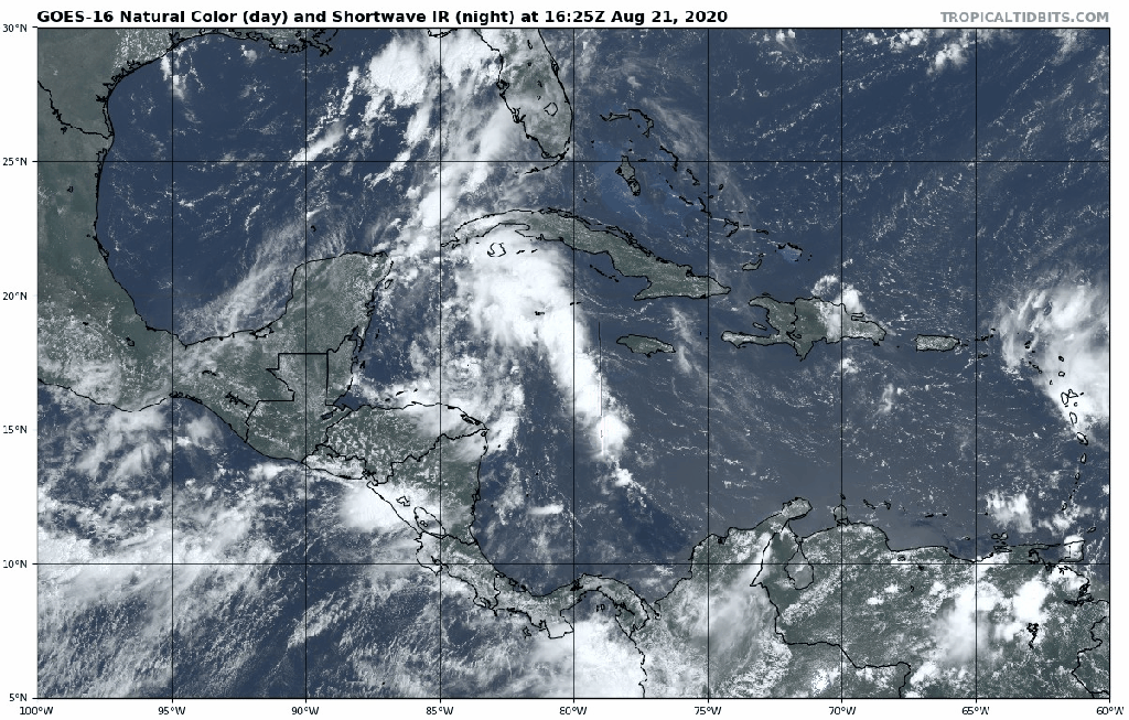
We’ll start with Tropical Storm Laura, as it is the “stronger” of the two systems at the moment, though you wouldn’t know it from looking at satellite pictures. As of 5pm EDT, Laura was centered about 40 miles east of Antigua with maximum sustained winds near 40 mph, and was moving toward the west at 17 mph. Tropical Storm Warnings are in effect for much of the northeastern Caribbean and Hispaniola, with a Tropical Storm Watch in effect for the southeastern Bahamas and the Turks and Caicos Islands. Laura does not have much thunderstorm activity associated with it, and the 40 mph estimate for winds may be very generous. Antigua has not reported winds higher than 10 mph all day long, though winds have gusted as high as 25 mph on Sint-Maarten.
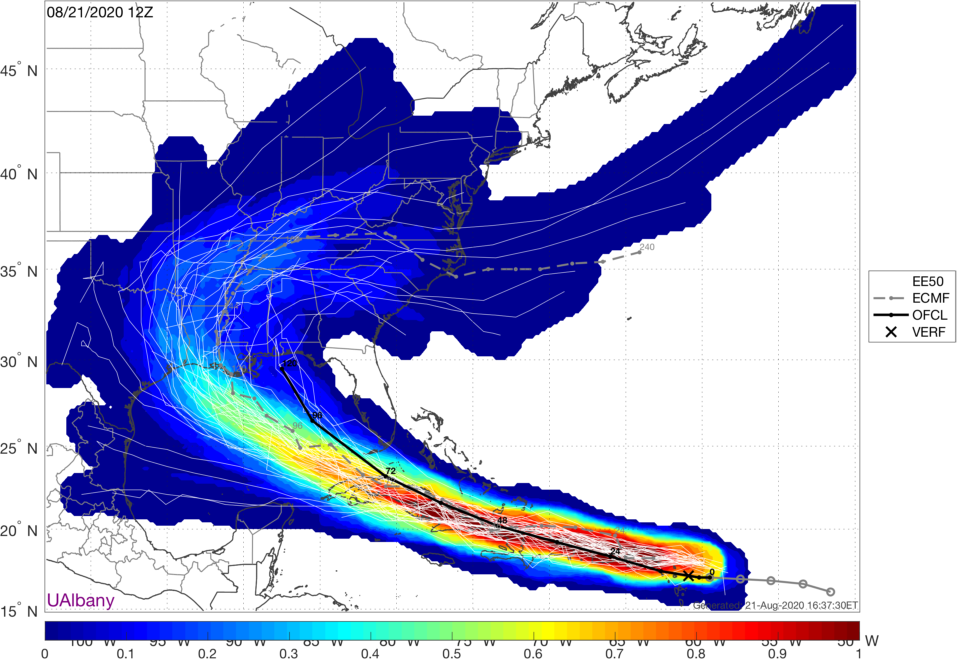
The forecast for Laura is both simple and complicated at the same time. With a large ridge of high pressure over the Atlantic, Laura will continue west-northwestward for the next few days. That’s the simple part. Exactly where the center tracks has huge implications on its intensity. A track near or over Puerto Rico and then near or over Hispaniola and/or Cuba will mean the system remains very weak, if it even survives. However, if the center stays over water, especially if it remains far enough away from land, then it may have a chance to strengthen. The official forecast from the National Hurricane Center calls for it to become a hurricane late Monday or early Tuesday while moving into the southeastern Gulf of Mexico. While this is certainly possible, we’ve got a long way to go before determining how likely this scenario is.
In the short term, we can expect some heavy rain and gusty winds across the northeastern Caribbean and into Puerto Rico and Hispaniola over the next couple of days. Rainfall totals of 3-6 inches and locally heavier will lead to flooding and mudslides.

Meanwhile, in the western Caribbean we have Tropical Depression 14. As of 5pm, it was centered about 255 miles southeast of Cozumel, Mexico with maximum sustained winds near 35 mph, and was moving toward the northwest at 13 mph. A Tropical Storm Warning and Hurricane Watch are in effect for the Yucatan Peninsula of Mexico from Punta Herrero to Cancun. The Tropical Storm Warning actually extends along the north coast of the Yucatan to Dzilam.
The depression appeared to have 2 low-level centers this morning based on reconnaissance information, but they have now consolidated into one center. Despite that, the system has been slow to strengthen, despite seemingly favorable conditions with warm waters and low wind shear. The forecast from the National Hurricane Center calls for some strengthening before the storm makes landfall in the northeastern Yucatan Saturday night. Assuming it becomes a Tropical Storm, it will be named Marco.
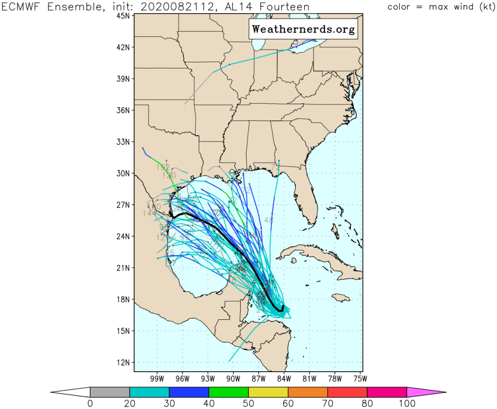
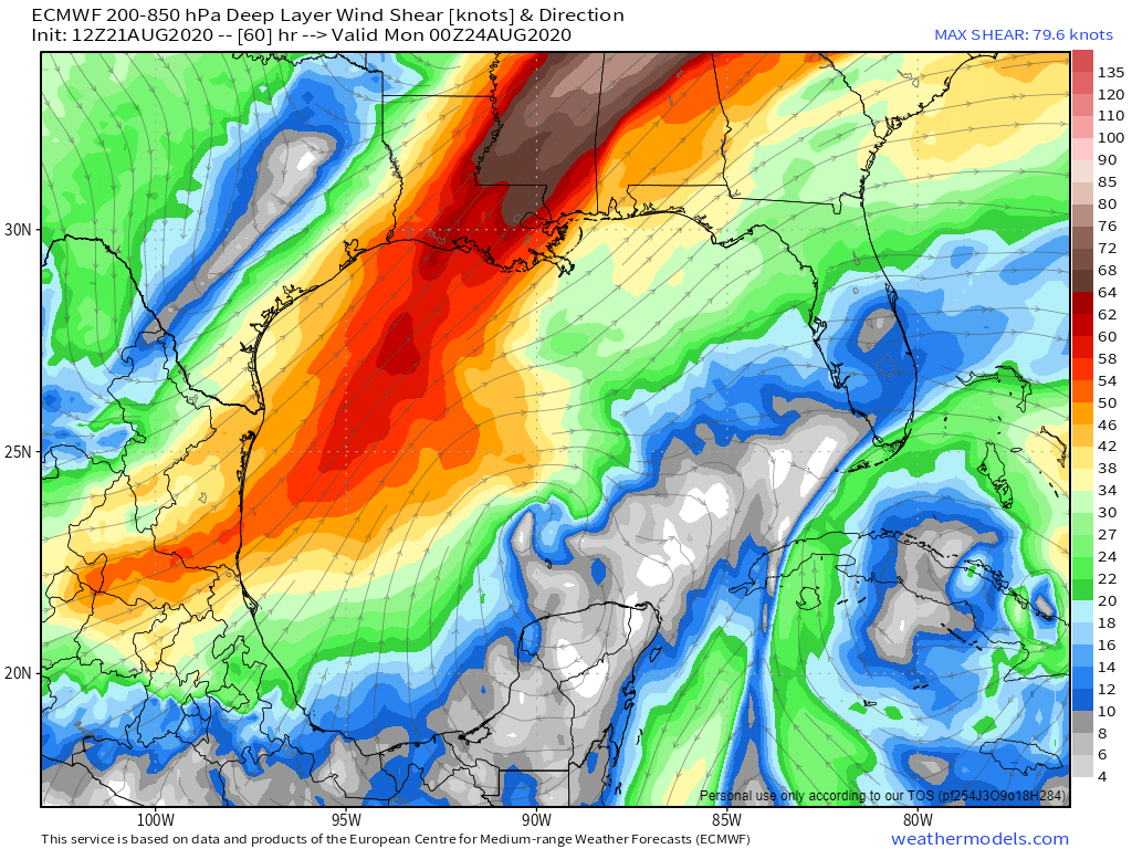
Once it emerges into the Gulf of Mexico, the questions increase. Will it continue northwestward or bend more toward the west-northwest? This will be determined by how strong the ridge over the Atlantic is. Some models show it building westward into the Gulf, which would send TD 14 (and also TS Laura) on a more west-northwestward track. How strong will TD 14 get? There’s plenty of warm water over the Gulf, but wind shear is forecast to increase, which will limit the strengthening of the system.
So, despite the media hype of “2 hurricanes in the Gulf at the same time” for early next week, the odds seem to be just as good that we may not have any hurricanes in the Gulf. There could be 2 tropical storms, or maybe 1 hurricane, or maybe only 1 storm. At this point, it is just to early to make that call. The other ridiculous statement we’ve heard is that the storms could collide. This just doesn’t happen. If two storms get close to each other, we get what is called the Fujiwhara Effect. Essentially, they start to rotate around each other. Alternately, if they get close to each other and one is considerably stronger than the other, the circulation around it could create enough wind shear to essentially destroy the weaker of the two storms.
Finally, another tropical wave is approaching the Cabo Verde Islands. It has some potential for development, and will be watched as it crosses the Atlantic over the next several days.
