This will not be a good week to take a vacation down along the Gulf Coast, especially from Louisiana into Texas, and COVID has nothing to do with it.

Tropical Storm Marco is the more immediate threat. As of 11am EDT Sunday, Marco was centered about 325 miles south-southeast of the mouth of the Mississippi River, moving toward the north-northwest at 14 mph. Maximum sustained winds were near 70 mph. Tropical Storm and Hurricane Watches and Warnings as well as Storm Surge Watches and Warnings are in effect for portions of the northern Gulf Coast.
Marco’s forecast is a bit complicated. The warm waters of the Gulf provide ample fuel for Marco to strengthen, and it could become a hurricane later today. However, as it heads northward, southwesterly shear will increase, which will help weaken the storm. Although hurricane warnings are in effect, Marco could weaken to a tropical storm before making landfall, likely along the Louisiana coast Monday afternoon or evening. Since there is little difference between a strong tropical storm and a weak hurricane, this has little impact on what will actually occur across the region.
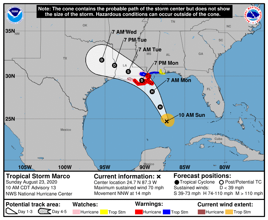
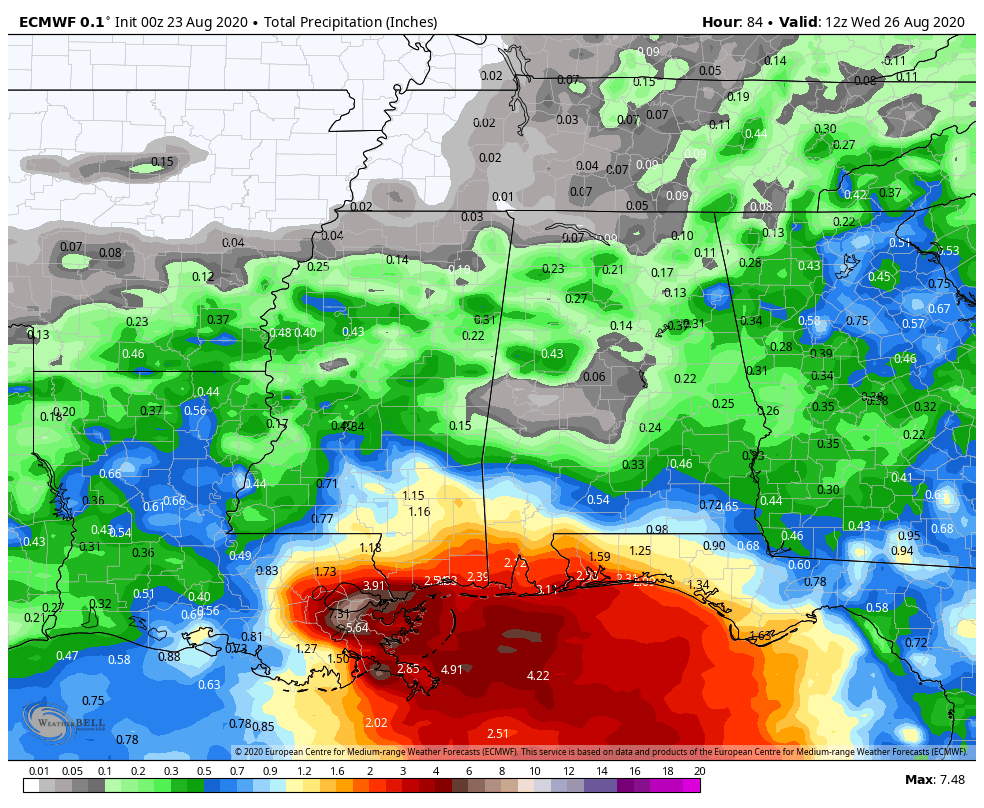
Marco will produce strong winds, mainly along the coast, and a storm surge of up to 6 feet will result in flooding along the coast and in the low-lying bayous of southern Louisiana. However, Marco’s biggest threat will be flooding from heavy rainfall. Rainfall totals of 3-6 inches and locally heavier will result in flooding in many areas. This is exacerbated in New Orleans, where much of the city itself is below sea-level and even heavy thunderstorms can produce flooding. We’re not expecting Katrina-level flooding, and the levees shouldn’t be tested too much by this storm, but widespread flooding is likely.
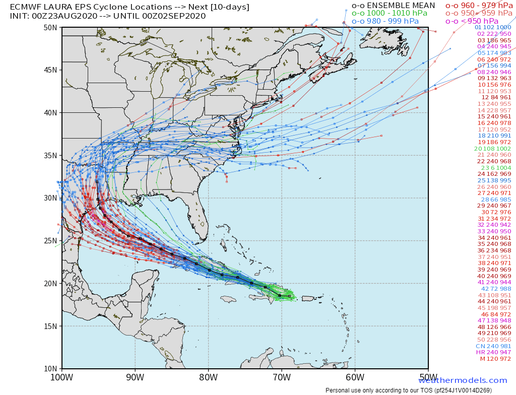
Marco is the initial threat, but Tropical Storm Laura is the more significant threat to the Gulf Coast. As of 11am EDT Sunday, Laura was centered about 95 miles southeast of the eastern tip of Cuba, moving toward the west-northwest at 21 mph. Maximum sustained winds were near 50 mph. Tropical Storm Warnings are in effect for parts of the Dominican Republic, Haiti, Cuba and the Southeastern Bahamas, with Tropical Storm Watches in effect for the Central Bahamas and the Florida Keys.
In the near-term, Laura is expected to traverse the entire length of Cuba for the next day or so, producing heavy rain and gusty winds. Heavy rains will diminish across the Dominican Republic and Haiti today as Laura pulls away. With the center interacting with land, little strengthening is anticipated for the next 24-36 hours, and some weakening is possible. Once we get to late Monday, things become a bit more complicated.
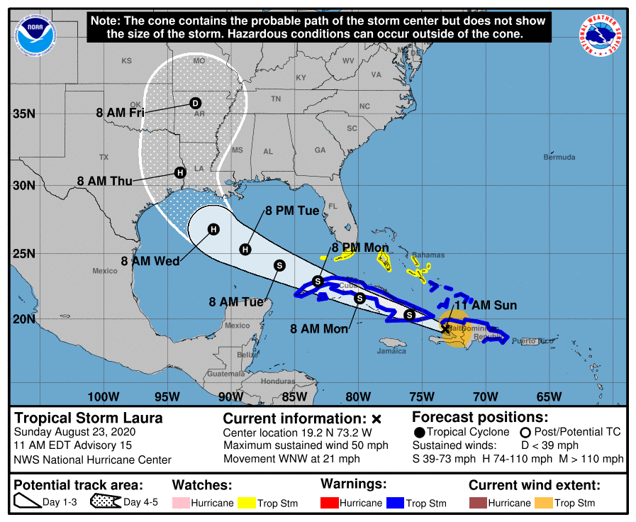
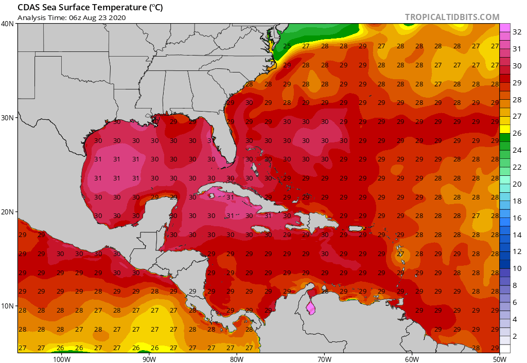
Laura is expected to move into the southeastern Gulf of Mexico Monday evening as a tropical storm. Once it does, it will find an environment that is favorable for strengthening. Water temperatures are well into the 80s, providing plenty of fuel for the system. (Tropical systems need water warmer than 80F/26C to survive and/or strengthen) A ridge of high pressure will also be building in aloft, resulting in very little wind shear. This is also an area that climatologically favors rapid intensification of tropical systems. Several models show the potential for Laura to quickly become a hurricane and possibly a major hurricane as it moves across the Gulf of Mexico on Tuesday. It should be noted that intensity forecasts for tropical systems, especially from forecast models, have been known to be rather poor.
The track forecast for Laura is also a bit uncertain. The ridge of high pressure building in will help steer Laura more towards the west-northwest. How strong that ridge actually is will help determine how far west Laura moves. While the models were nearly unanimous just 24 hours ago that Laura was heading towards the Central Gulf Coast, they have shifted westward, putting parts of Texas and western Louisiana in the crosshairs. Additional shifts are likely over the next day or two as the models adjust to what is actually going on in the atmosphere. For now, residents of the Gulf Coast from Central Texas to Alabama should keep a close eye on Laura’s progress.
There are no other systems in the Atlantic that are being monitored right now, but we are approaching the peak of Hurricane Season, so that will likely change soon. There are two systems in the Eastern Pacific that may become tropical depressions in the next day or two, and Typhoon Bavi will be a threat to Korea over the next 24-48 hours in the Western Pacific.
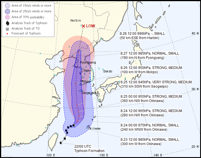
As of 11am EDT, Typhoon Bavi was centered about 600 miles south-southwest of the southwestern South Korea, moving toward the northeast at 9 mph. Maximum sustained winds were near 80 mph. Bavi is expected to turn more toward the north over the next 12-24 hours, with some additional strengthening expected. The current forecast calls for Bavi to move into the Yellow Sea, and pass just west of South Korea, before making landfall in extreme northwestern North Korea, then it will move into extreme northeastern China where it will rapidly weaken. Strong winds and storm surge flooding are likely across the Korean Peninsula over the next few days, with heavy rain likely causing flooding along the Peninsula as well as in northeastern China. Parts of this region have received heavy rain recently, and some flooding has already occurred, so this will exacerbate it in some areas.
