First, our apologies for the brief post last week and the missing temperatures in the forecast. We at Storm HQ were taking a cruise to Bermuda for a much-needed vacation, and our internet connection on the ship was even worse than expected. It took far too long to even get what we wrote posted. We’re back in the Storm HQ World Headquarters Compound now, so we’re back to full updates.

As for the coming week and the upcoming Labor Day Weekend, we’ll start off with high pressure in control, providing the region with dry and cool conditions today, but a warming trend is expected over the next few days. Some low clouds may remain in place this morning along the coast, thanks to the onshore flow around the high pressure area to our north and a deepening system south of Nova Scotia. The high pressure system will eventually win out, with sunshine developing along the coast by afternoon as well.
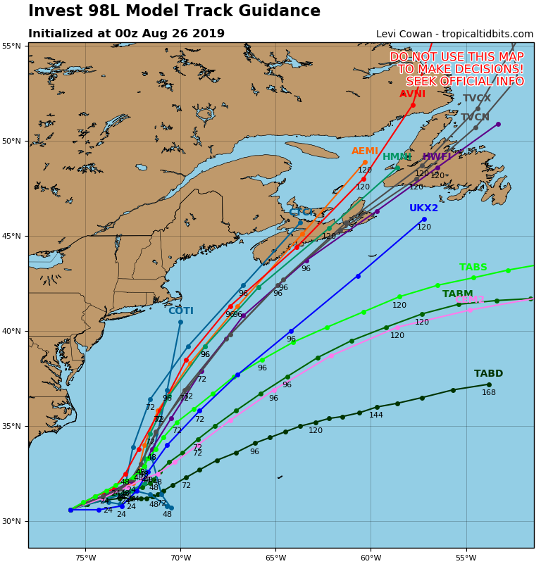
A cold front will start to approach the region on Wednesday, which means we should turn warmer and more humid, but there’s a possible fly in the ointment. There’s a system off the Carolinas right now that could become a tropical or subtropical storm later today (we’ll likely have a special blog post about this storm and Dorian either later today or on Tuesday). Right now, this system looks like it will head towards the northeast, and stay well offshore, but that is not set in stone yet. A track more towards the north-northeast could bring it close enough to at least bring in some clouds to southeastern New England. A return of onshore flow would mitigate any warm and humid weather along the coast, and depending on how close the system passes, we could even see a few showers reach the Outer Cape and the Islands. Obviously, we’ll keep an eye on this situation over the next few days. We think it’s a low-probability that it has an impact on us, but that probability is nowhere near zero right now.
Back to that cold front, it likely produce some showers and a few thunderstorms Wednesday night into Thursday before it moves offshore. High pressure builds in behind the front on Friday with some drier weather, but another cold front moves will approach on Saturday. This one doesn’t look like it will have much moisture to work with, so we’re only expecting a few showers. High pressure builds in behind the front with cooler weather on Sunday. For Labor Day on Monday, the “traditional end of summer”, it looks like we’ll turn a littler warmer again as the high starts to move offshore.
You’re probably wondering if we’re done with the heat for the year. The answer is “not likely”. We’ve had plenty of 90-degree days well into September (and on very rare occasions into October. In fact, at least one model is showing some very warm weather the following weekend, with temperatures well into the 80s and close to 90 again. It’s nearly 2 weeks away, so it’s hardly set in stone, but don’t take the air conditioner out of the window and out away your summer clothes just yet.

Monday: Low clouds linger across southeastern Massachusetts in the morning, bright sunshine everywhere in the afternoon. High 68-75, coolest along the coast.
Monday night: Clear skies. Low 47-54, warmest in the urban areas.
Tuesday: Sunshine and some afternoon clouds. High 71-78.
Tuesday night: Mostly clear. Low 53-60.
Wednesday: Partly to mostly sunny. Clouds move in at night with some showers possible towards daybreak. High 75-82, a little cooler along the coast.
Thursday: Intervals of clouds and sunshine with scattered showers, possibly a thunderstorm, mainly during the morning. High 77-84.
Friday: Plenty of sun. High 78-85.
Saturday: Partly to mostly sunny, some showers are possible at night. High 79-86.
Sunday: A mix of sun and clouds. High 71-78, coolest along the coast.
Labor Day: A sunny start, then clouds move in. High 73-80.

One thought on “Weekly Outlook: August 26 – September 2, 2019”