It’s been a very quiet hurricane season so far, not just in the Atlantic, but in the Pacific as well, but that appears to be changing.

The most immediate concern is Tropical Storm Dorian. As of 2pm Monday, Dorian was centered about 95 miles east-southeast of Barbados, and was moving towards the west-northwest at 14 mph. Dorian has maximum sustained winds near 60 mph, and additional strengthen is expected. Tropical Storm Watches and Warnings are in effect for much of the Lesser Antilles, and a Hurricane Watch is in effect for St. Lucia.

Dorian is expected to pass very close to Barbados this evening, and then close to St. Lucia or St. Vincent overnight tonight or early Tuesday. Because Dorian is not that large, the worst effects (damaging winds, torrential rainfall) will likely be limited to these islands.

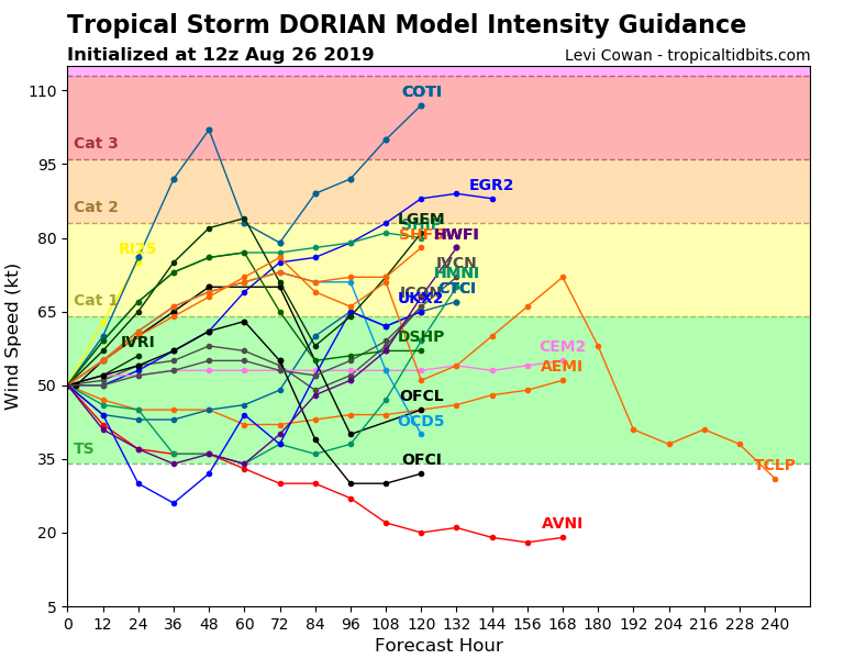
Once Dorian moves past the Lesser Antilles, the questions become tougher to answer. The official forecast from the National Hurricane Center calls for Dorian to become a hurricane and turn northwestward, passing close to western Puerto Rico on Wednesday and then eastern portions of Dominican Republic Wednesday night and early Thursday, with some weakening as it interacts with land. In terms of the track itself, most of the forecast models are clustered in this area, give or take 100 miles. The intensity forecast is the biggest question mark for now. The Hurricane Center is calling for the storm to have maximum sustained winds of 80 mph when it reaches Puerto Rico and Hispaniola. However, looking at the various models, they are showing that it could be as strong as a Category 3 system, or as weak as a tropical depression. Intensity forecasts are still the toughest part of forecasting tropical systems, and for a small storm that has dry air all around it, this one is especially tough. Frankly, at this point, we wouldn’t be surprised with any outcome.
What about when it gets beyond Hispaniola and Puerto Rico? The official track and the various models all show the storm heading into the Bahamas and possibly towards Florida or the Southeast. It is still WAY too early to speculate on that (but that won’t stop the hype machine from Twitter and the Facebook Forecasters). First, we need to see if Dorian even survives that long. The mountains in central Hispaniola rise as high as 10,000 feet. Many storms that cross this area get torn apart by the terrain and dissipate. If (and that’s a big “if”) it survives, we’ll have to see what kind of shape it’s in when it emerges into the Bahamas before we can assess it’s future. This is all presuming the storm turns northwestward and heads towards Puerto Rico and Hispaniola. There’s nothing that says it won’t continue westward and heads towards Cuba or Jamaica. Just because none of the computer models are forecasting it does not mean it can’t happen.
Meanwhile, off the East Coast, a low pressure system is developing about 300 miles southeast of Cape Hatteras, NC this afternoon. This system could become a tropical or subtropical storm later today or tomorrow. As we mentioned in our Weekly Outlook, while the system is expected to stay well offshore and not impact the East Coast, this is far from definite. Some of the forecast models this afternoon show some moisture from the system interacting with an approaching cold front to bring some rain into parts of eastern New England Wednesday night and Thursday. Obviously, this will depend on exactly where the system tracks.

Whether or not the system has any impact on New England, it will likely bring some gusty winds and heavy rain to portions of Atlantic Canada toward the end of this week. Rainfall totals of 2-4 inches and locally heavier are possible along with winds gusts to 50 mph along the coast, possibly higher, depending on how strong the storm gets. While this seems like an average Nor’easter, it will come on the heels of a non-tropical system that will bring heavy rain and strong winds to the same area tonight into Wednesday. Not exactly an ideal ending to summer for parts of the region.
