We’ve got a couple of very nice days coming up across the region.
Average high temperatures for mid-September are in the lower to middle 70s. Image provided by Weathermodels.com
A weak cold front moves through this evening with little fanfare, then high pressure builds in with sunshine and cooler temperatures for Friday and Saturday. An upper-level disturbance moves through on Sunday with some showers likely, especially in the afternoon. Monday is a bit of a tricky forecast. Some models showed an upper-level low pressure area hanging around with more clouds and possibly some additional showers, but more recent trends have been for high pressure to build back in with drier weather.
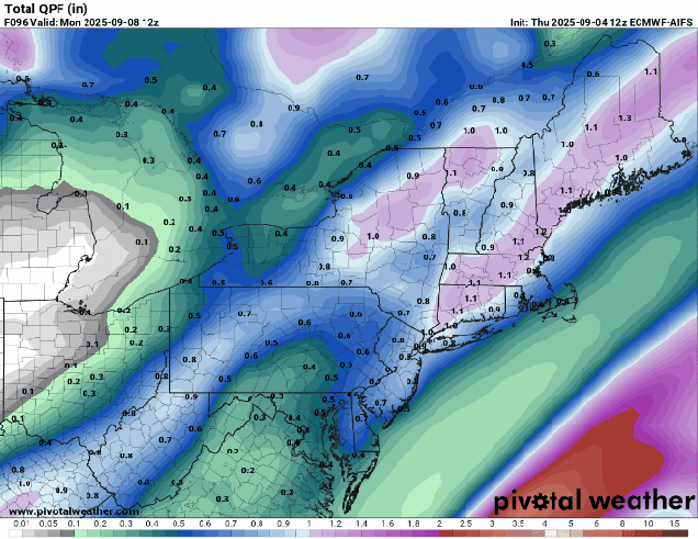
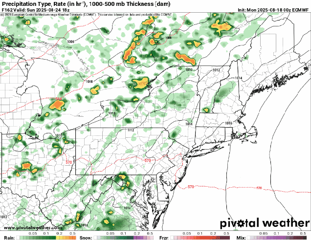
The showers on Sunday will not make much of a difference for the ongoing drought. Images provided by Pivotal Weather.
Thursday night: Evening clouds, then becoming clear. Low 52-59.
Friday: Plenty of sunshine. High 67-74.
Friday night: Clear skies. Low 47-54.
Saturday: Morning sunshine with some afternoon clouds. High 70-77.
Saturday night: Partly cloudy. Low 52-59.
Sunday: Intervals of clouds and sun with some showers likely in the afternoon. High 71-78.
Sunday night: Any showers end in the evening, clearing overnight. Low 52-59.
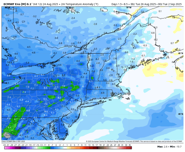
Much of the upcoming week will be dominated by quiet and cool weather thanks to a large high pressure area.
Temperatures will be several degrees below normal for much of the week. Image provided by WeatherBell.
The cold front that produced severe weather on Saturday and a cool but beneficial rainfall on Sunday has pushed offshore and high pressure will build in bringing drier air in along with temperatures that are below normal for today and Tuesday. Things could get a little complicated for part of the region for Wednesday. An area of low pressure will pass well offshore, but the precipitation shield around the edge of the system could get close to parts of the South Coast, possibly even a little farther northward. However, the high to the north looks like it may remain strong enough to keep most of the rain offshore, so we’re going to lean towards a dry forecast for now. High pressure returns for the end of the week and start of the weekend. A cold front will move through with little fanfare on Sunday, keeping us dry.
An offshore system may produce some rain across Cape Cod and the South Coast, or maybe it won’t. Images provided by Pivotal Weather.
Monday: Partly sunny. High 66-73.
Monday night: Clear to partly cloudy. Low 47-54.
Tuesday: Sunshine and some afternoon clouds, breezy near the coast. High 66-73.
Tuesday night: Partly to mostly cloudy. Low 49-56.
Wednesday: Intervals of clouds and sun, chance for a few showers near the South Coast and Cape Cod. High 65-72.
Wednesday night: Any showers end in the evening, becoming partly cloudy to clear. Low 50-57.
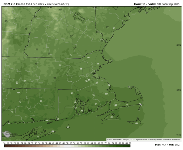
Even though the calendar says September it’s still astronomical summer, and it will feel like it for the next few days.
Dewpoints will be near or over 70 Saturday afternoon. Image provided by WeatherBell.
After a strong of rather nice days changes are on the way. A warm front will cross the region tonight, possibly accompanied by a few showers before daybreak on Friday. Once the front lifts northward, we’ve got warm and humid weather on the way for much of Friday and Saturday, with temperatures getting into the 80s along the coast, and dewpoints creeping back into the 60s or even lower 70s. For the most part it will be mostly sunny on Friday after the clouds move out in the morning, with some patchy fog Friday night. During the day on Saturday we’ll see clouds start to move back in ahead of an approaching cold front. The trend in the models recently has been to slow down this front, so for now, it looks like we’ll stay dry for most of the day Saturday. Some showers and thunderstorms will start to move in towards evening from west to east, with showers likely during the overnight hours. Sunday’s forecast is a little uncertain at this point. The showers should end during the morning, but some models continue to slow down the front with the showers not ending until afternoon from Boston southward, and possibly not until Sunday evening near the South Coast and Cape Cod. This will have an impact on temperatures as well, since the longer it rains, the less chance temperatures will warm up in the afternoon. With the Patriots season opener kicking off in Foxborough at 1:00 PM, any rain could impact not only playing conditions to start the game, but also tailgating beforehand. The front should push offshore at night, with high pressure building in for Monday with cooler and drier weather.
Most of the models aren’t forecasting a lot of rain for the weekend, but every little bit helps to fight the drought. Images provided by Pivotal Weather.
Thursday night: Increasing clouds, chance for a few late-night showers. Low 58-65.
Friday: Morning clouds, maybe a shower, then becoming partly to mostly sunny, breezy, and humid. High 78-85.
Friday night: Clear to partly cloudy, a little patchy fog may develop. Low 62-69.
Saturday: A sunny start, then clouds move in during the afternoon, showers and thunderstorms possible late in the day well north and west of Boston, breezy. High 81-88, cooler near the South Coast and Cape Cod.
Saturday night: Cloudy with showers and thunderstorms likely. Low 57-64, possibly a little warmer across southeastern Massachusetts and Cape Cod.
Sunday: Showers gradually ending from northwest to southeast, some late-day sunny breaks develop well north and west of Boston. High 67-74.
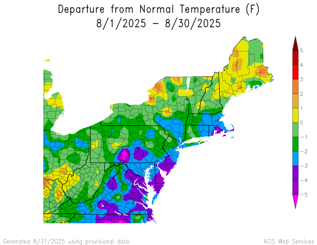
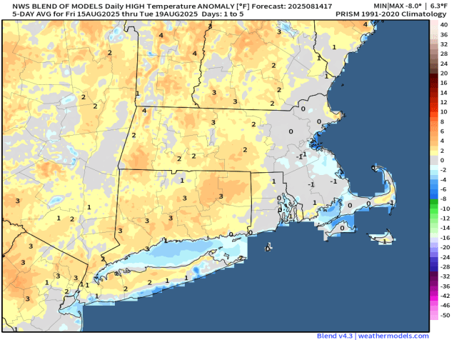
Happy Labor Day and welcome to September. It marks the unofficial end of summer and the official start of meteorological autumn. College football is underway, the pros start this week, hockey training camps start up in a couple of weeks, pumpkin everything is available everywhere, and after a cool August, warmer weather will return for a few days this week.
Temperatures were below normal across much of the Northeast during August. Image provided by the Northeast Regional Climate Center.
High pressure will keep us dry for the first half of the week, likely right into Thursday, but with an upper-level low nearby, we’ll still have some afternoon clouds each afternoon. Temperatures will be close to normal for early September to start the week, but as the high slides offshore, southwest winds will bring warmer and eventually more humid air in towards Wednesday and Thursday. A slow-moving cold front will move in Thursday night, with some showers and a few thunderstorms likely on Friday. With the front taking its time, Saturday may also be a warm and humid day, with the potential for some additional showers or thunderstorms, depending on when the front actually moves across the region. High pressure should build in behind the front for Sunday with cooler and drier weather, just in time for the Patriots home opener in Foxborough.
We’re not expecting a lot of rain with the cold front at the end of the week, but every little bit helps as the drought worsens. Images provided by Pivotal Weather.
Monday: Partly sunny. High 71-78, coolest along the coast.
Monday night: Partly cloudy with some patchy fog possible. Low 52-59.
Tuesday: Sunshine and some afternoon clouds. High 72-79, coolest along the coast.
Tuesday night: Clear to partly cloudy. Low 51-58.
Wednesday: A mix of sun and clouds. High 74-81, coolest along the coast.
Wednesday night: Clear to partly cloudy. Low 53-60.
Thursday: Partly to mostly sunny, breezy. High 75-82, coolest along the South Coast and Cape Cod.
Thursday night: Becoming cloudy, showers possible late at night. Low 57-64.
Friday: More clouds than sun with showers and a few thunderstorms likely, breezy, humid. High 73-80.
Saturday: Partly sunny, humid, a few additional showers or thunderstorm possible, breezy. High 75-82.
Sunday: Becoming partly to mostly sunny, drier. High 70-77.
Much of the Labor Day Weekend will feature dry but somewhat cool conditions.
Temperatures will be below normal this weekend. Image provided by Weathermodels.com
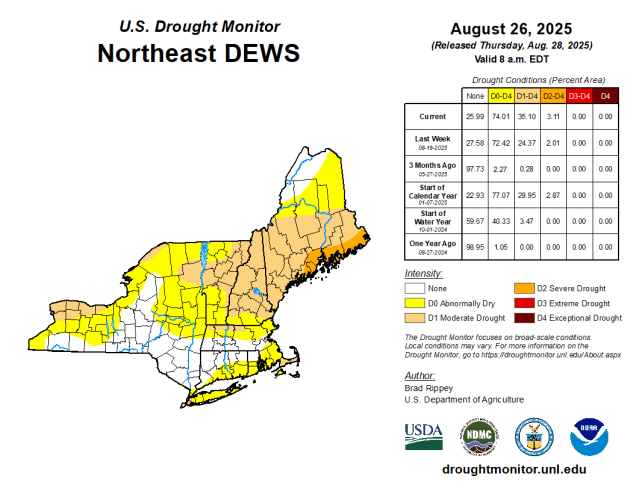
Clouds will start to move in and thicken up tonight as a cold front heads out way from the Great Lakes. That front will bring us some showers and a few thunderstorms during the day on Friday. While we need the rain as drought conditions continue to expand across the region, this will not be a drought-buster. We’re only expecting scattered showers, with some places seeing little, if any, rain from them. There will be a few downpours as well, and don’t be surprised if one or two storms produce some gusty winds and small hail, but overall, this isn’t a big deal. Once the front moves offshore high pressure will build in for the rest of the Labor Day Weekend. However, we’ll also have an upper-level low pressure area moving into the Northeast. That means that we’ll see some clouds popping up each day during the late morning and afternoon hours, dissipating after sunset. These clouds will be most numerous on Saturday, fewer on Sunday, and even fewer on Monday.
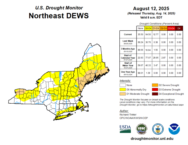
Drought conditions are worsening across the region. Image provided by the National Drought Mitigation Center.
Thursday night: Increasing and thickening clouds. Low 56-63.
Friday: More clouds than sunshine with some showers and a few thunderstorms developing. High 70-77.
Friday night: Showers and storms ending in the evening, clearing after midnight. Low 48-55.
Saturday: Morning sunshine with some afternoon clouds. High 68-75.
Saturday night: Clear skies. Low 49-56.
Sunday: Sunny in the morning, partly sunny in the afternoon. High 69-76.
The final week of summer (traditional and meteorological) has arrived, and for the most part, the weather will be fairly nice, but a little on the cool side.
Below normal temperatures are expected for most of the upcoming week. Image provided by WeatherBell.
We start the week off with some rain across the Cape and Islands as a weak low pressure area passes by offshore. The rain should end during the morning, but we’ve got a cold front moving in from the west. We could see some sunshine, especially inland during the morning, but as the front moves in, we’ll see some showers and thunderstorms developing in the afternoon. They shouldn’t be that strong, but a few could produce some gusty winds and heavy downpours. They’ll quickly subside during the evening as the front pushes offshore, then high pressure starts to build in with cooler and drier conditions. However, we’ll also have an upper-level low pressure area moving in from the Great Lakes, and this will likely generate some clouds for Tuesday afternoon. It’ll probably be a little too dry for any showers to pop up, but it wouldn’t be a complete shock if a few days. Another disturbance rotating around that upper low will move in for Wednesday, with some morning sun followed by afternoon clouds, and this day may feature a better chance for some pop-up showers during the afternoon. Thursday looks like another dry day with some afternoon clouds and temperatures that remain a little below normal for late August.
A series of upper-level disturbances will influence our weather for much of the next week. Loop provided by Tropical Tidbits.
As we get to Labor Day weekend, we’ll see another low pressure area moving in on Friday, with another round of showers and possibly some thunderstorms. The system will take its time moving out as another upper-level low moves in, so Saturday may feature more clouds and a few showers, especially early, but we should see some improvement during the afternoon. Sunday looks pretty nice, but we’ll still have an upper-level low nearby, so expect more clouds, but for now, we’re not expecting more showers. High pressure builds in for Labor Day with dry and seasonably warm conditions, though some clouds are still likely as that upper-level low will be slow to depart.
Friday could feature some showers and thunderstorms, but much of the rest of the weekend looks dry. Images provided by Pivotal Weather.
Monday: Morning showers across Cape Cod, otherwise morning fog burns off revealing a mix of sun and clouds with some showers and thunderstorms likely during the afternoon. High 75-82.
Monday night: Any showers end in the evening, becoming clear overnight with some patchy fog. Low 56-63.
Tuesday: Morning sun, then some clouds pop up during the afternoon. High 72-79.
Tuesday night: Clear to partly cloudy. Low 52-59.
Wednesday: Partly sunny, chance for a few showers during the afternoon. High 70-77.
Wednesday night: Mostly clear. Low 51-58.
Thursday: Morning sunshine with afternoon clouds. High 73-80.
Thursday night: Partly cloudy. Low 53-60.
Friday: Partly sunny with showers and a few thunderstorms developing in the afternoon, tapering off late at night. High 71-78.
Saturday: Any lingering showers end early, some afternoon sunshine develops. High 68-75.
Hurricane Erin will pass well offshore over the next 24 hours while we enjoy some rather nice weather for most of the upcoming weekend.
Average high temperatures in late August are around 80. Image provided by Weathermodels.com
High pressure will slowly build into the region this evening, allowing skies to gradually clear out tonight. With the high in control on Friday we’ll have lots of sunshine, with temperatures getting back close to where they should be in the latter half of August. It will remain breezy, especially during the morning, due to the gradient between the high building in and distant Hurricane Erin pulling away offshore (more on that in a moment). As the high moves off to the east on Saturday, southwest winds will usher warmer air in, with many areas away from the coast likely topping 80 degrees. We’ll see things start to change on Sunday as a cold front begins to slowly approach the region. Clouds will increase, and gusty southerly winds will develop, increasing humidity levels across the area. Some showers and thunderstorms are expected ahead of the front, but they should hold off until evening, so don’t cancel any outdoor plans for Sunday. The front will take its time moving through, with showers and thunderstorms expected for Sunday night into Monday. We’ll also be watching a small area of low pressure moving up the East Coast on Monday. While most of the models keep it far enough offshore to have little to no impact here, some bring it close enough to bring in a periods of steadier rain to Cape Cod and possibly southeastern Massachusetts Monday afternoon and evening. We’re leaning towards it staying too far offshore to impact us, but we are keeping an eye on it just in case.
Low pressure should remain offshore on Monday, but that doesn’t mean we’ll stay dry. Images provided by Pivotal Weather.
Hurricane Erin was centered about 400 miles northwest of Bermuda as of early Thursday afternoon, moving off toward the northeast at 18 mph. Maximum sustained winds were near 100 mph. Tropical Storm Warning are in effect for parts of the Mid-Atlantic coast as well as Bermuda. As Erin accelerates northeastward and steadily weakens conditions will improve across Bermuda and the East Coast, though rough seas and rip currents will still be a significant hazard into the weekend. With astronomically high tides, some minor coastal flooding is also still possible for the next day or two in parts of New England and Atlantic Canada.
Hurricane Erin remains a large and potent storm off the East Coast. Loop provided by NOAA.
There are two other tropical waves we’re keeping an eye on this afternoon, but neither is a significant threat to land at this time. A tropical wave is approaching the Leeward Islands this afternoon. It remains disorganized, but as it heads northwestward, conditions will become more favorable for development, and it could become a tropical depression over the weekend or early next week as it turns northward out over the open Atlantic. It will bring squally conditions to the Leeward Islands as well as the Virgin Islands and possibly Puerto Rico over the next few days, but otherwise won’t be a threat to land areas, though it could threaten Bermuda by early next week. Another wave is in the central Atlantic, and shows some signs of organization. While conditions are favorable for some development right now, they will become more hostile by this weekend, which would effectively end any further chances for development.
Hurricane Erin is pulling away from the East Coast but there are other areas we’re watching in the Atlantic. Loop provided by Tropical Tidbits.
Thursday night: Skies clear out from northwest to southeast, still breezy across Rhode Island, southeastern Massachusetts, and Cape Cod. Low 51-58, a little milder on Cape Cod.
Friday: Plenty of sunshine, winds diminish by early afternoon. High 77-84, a little cooler across Cape Cod.
Friday night: Clear to partly cloudy. Low 54-61.
Saturday: Sunshine and a few clouds. High 80-87, a little cooler across the South Coast and Cape Cod.
Some cooler weather is on the way for a good portion of the upcoming week. Hurricane Erin remains a potent storm east of the Bahamas, and could have a minor impact on the region later this week.
Temperatures will be below normal for much of the upcoming week. Image provided by Weathermodels.com
We’re starting the week off with high pressure building in, bringing us dry and rather cool conditions for Monday and Tuesday. Temperatures will only get into the 70s during the day, possibly staying in the 60s in a few spots, especially near the coast. Some of the normally cooler locations could drop into the 40s during the next few nights, especially tonight. Time to turn off the air conditioning and open the windows, but possibly grab an extra blanket at night. As we get to Wednesday, a weak disturbance will head out way from the Great Lakes, bringing in some clouds and a few showers as well. For now, the showers don’t look to be that heavy or widespread, but at this point, we need any rain we can get.
Drought conditions are expanding and worsening across the Northeast. Image provided by the National Drought Mitigation Center.
High pressure returns for Thursday with drier weather, and temperatures remaining on the cool side, but that might not be the whole story, as we’ll also need to keep an eye on Hurricane Erin. Erin should be passing well offshore (more on that a little later), but with a high to the northwest and the potent storm offshore, the gradient in between the two could result in some gusty winds across Cape Cod and the Islands, and possibly southeastern Massachusetts as well. In addition, the high clouds around the edge of Erin may dim the sun during the day. One thing that is definite is that Erin will produce rough seas, high waves, and a significant risk for rip currents at beaches across the region, especially across the South Coast and east-facing beaches on Cape Cod. When you add in the fact that there’s a new moon this weekend tides will be running astronomically high, so there is the chance for some coastal flooding in a few spots toward the end of the week.
Wave heights could reach 10 feet or more near the South Coast by Friday. Image provided by WeatherBell.
Once Erin pulls away Friday should be another sunny and cool day, but as the high pressure area moves offshore, it will allow warm and increasingly humid conditions to return on Saturday. Another frontal system may move in on Sunday with some showers and thunderstorms, but the timing is still in question, so don’t go cancelling any outdoor plans just yet.
Will Sunday be wet or will the showers hold off until late? It’s too early to tell. Images provided by Pivotal Weather.
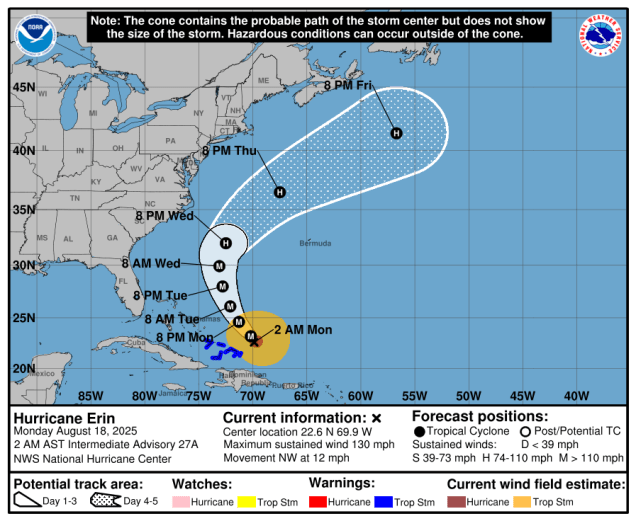
As for Hurricane Erin, it peaked as a Category 5 hurricane north of Puerto Rico on Saturday then weakened a bit, before restrengthening Sunday night. As of 2am Monday, Erin was centered about 110 miles northeast of Grand Turk Island, moving toward the northwest at 12 mph. Maximum sustained winds were near 130 mph. Erin will turn more toward the north over the next day or so, and could strengthen a little more before a weakening trend begins. Erin should pass in between the East Coast and Bermuda towards midweek before turning more toward the northeast and heading out into the open Atlantic. As Erin heads northward it will expand in size, and some of its outer bands could clip Bermuda and/or the Outer Banks of North Carolina with some squalls around midweek. Erin will generate high waves, rough surf, and a high danger for rip currents up and down the East Coast this week.
Forecast track for Hurricane Erin. Image provided by the National Hurricane Center.
Meanwhile, there’s another tropical wave we’ll be keeping an eye on in the Atlantic. The wave is pulling away from the Cabo Verde Islands today, and will make its way across the Atlantic this week. While conditions are not favorable for any development right now, toward the end of the week they could become a little more conducive, and some of the models show the potential for this system to develop towards next weekend as it heads toward the Lesser Antilles.
Another system crossing the Atlantic could develop later this week. Image provided by the National Hurricane Center.
Monday: Morning clouds, then becoming partly to mostly sunny, breezy early. High 69-76, coolest along the coast.
Monday night: Clear to partly cloudy. Low 47-54, a little warmer in urban areas and right along the coast.
Tuesday: A mix of sun and clouds. High 70-77.
Tuesday night: Partly cloudy. Low 54-61.
Wednesday: Partly sunny, chance for a few showers. High 71-78.
Wednesday night: Partly cloudy. Low 54-61.
Thursday: Sunshine filtered through some high clouds, especially across southeastern Massachusetts and Cape Cod, where it will also be breezy. High 71-78.
Thursday night: Clear to partly cloudy. Low 53-60.
Friday: Some high clouds early, otherwise sunny, breezy across southeastern Massachusetts and Cape Cod. High 77-84.
Saturday: Sunshine and some afternoon clouds, breezy. High 80-87, a little cooler at the coast.
Sunday: Partly sunny, breezy, a little more humid, chance for some showers and thunderstorm. High 77-84.
A good portion of the upcoming weekend should feature some very nice mid-summer weather. Meanwhile, Tropical Storm Erin continues to gather strength in the central Atlantic.
Temperatures will average close to normal through the weekend despite some ups and downs. Image provided by Weathermodels.com
A cold front will slide offshore this evening, taking any remaining shower and thunderstorm activity with it. Behind it, high pressure builds in with sunshine, cooler temperatures and lower humidity for Friday. As the high moves off to the east, temperatures will start to creep back up on Saturday, but will be pretty close to where they should be in mid-August. Sunday looks to be another hot and humid day, though it won’t be anywhere near as oppressive as some days we had earlier in the summer. A cold front will be approaching the region though, and it may produce some showers and thunderstorms late in the day and into the evening. High pressure then builds back in with much cooler and drier air for Monday.
Tropical Storm Erin continues to slowly intensify in the central Atlantic. Loop provided by NOAA.
Out in the central Atlantic Ocean, Tropical Storm Erin continues to slowly get its act together. As of 11am Thursday, Erin was centered about 890 miles east of the Northern Leeward Islands, moving toward the west at 17 mph. Maximum sustained winds were near 60 mph. Conditions are becoming more favorable for Erin to intensify, as wind shear is limited at this time, the atmosphere ahead of Erin is more moist, and sea surface temperatures gradually increase as you head westward. Erin is expected to become a hurricane on Friday. As for the track, that’s fairly simple for now. A large ridge of high pressure remains in place to the north, so Erin should continue in a general west to west-northwest direction for the next few days, likely passing north of the Caribbean this weekend. It may be close enough that some of the outer bands from the storm will bring squally conditions to parts of the Virgin Islands and Puerto Rico, but a direct hit is unlikely at this time. Erin should continue to intensify this weekend, likely become a major hurricane.
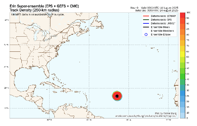
Beyond this weekend, things become a little less clear. Erin will encounter a weakness in the ridge to the north, which should allow the storm to turn more toward the northwest and then north. However, when that turn occurs and how quickly it will make the turn are still very uncertain. Most of the models show the storm passing in between Bermuda and the East Coast, eventually turning northeastern and heading out into the Atlantic, but that is far from a lock at this point. The earlier the turn happens, the bigger the threat to Bermuda. The later the turn happens, the more likely that the storm could impact parts of the Bahamas. The storm will produce rough surf and increase the chances for riptides along the East Coast next week, but for now at least, that looks to be the only impact from the storm. That could change if the turn happens later, but we’ll worry about that if it happens.
Ensemble forecasts for the track of Erin. Loop provided by Tomer Burg.
There’s also a system we’re keeping an eye on in the Bay of Campeche. A cluster of thunderstorms has been slowing organizing over the past day or so, and as it heads northwestward, conditions are favorable for some development over the next day or so. The system doesn’t have a lot of time, as it will likely move inland somewhere close to the Texas/Mexico border late Friday or Friday night, but it could become a Tropical Depression or Tropical Storm before moving inland. Whether it develops of not, heavy rain, gusty winds, and coastal flooding are possible in this region for the next few days.
We’re also keeping an eye on a developing system in the western Gulf of Mexico. Loop provided by NOAA.
Thursday night: Any lingering showers or thunderstorms end in the evening, becoming clear to partly cloudy overnight. Low 62-69.
Friday: Partly to mostly sunny, not as humid. High 76-83, coolest along the coast.
Friday night: Partly cloudy, some patchy fog may develop. Low 57-64.
Saturday: Sunshine and a few clouds. High 81-88, cooler near the coast.
Saturday night: Clear to partly cloudy. Low 62-69.
Sunday: Morning sun, then increasing clouds, chance for a late-day shower or thunderstorm, humid. High 85-92, a little cooler across the South Coast and Cape Cod.
Sunday night: Any showers or thunderstorms end in the evening, becoming partly cloudy overnight. Low 59-66.
Monday: A mix of sun and clouds, cooler and less humid. High 72-79.
Once again, most of this week will be fair quiet weather-wise. The tropics, however, are not going to be quiet.
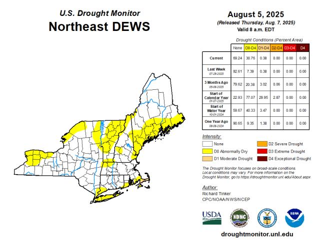
Drought conditions are beginning to re-emerge, especially in SE Massachusetts and Cape Cod. Image produce by the National Drought Mitigation Center.
High pressure remains in control for the first half of the week with warm and increasingly humid conditions. While the humidity levels will be on the rise, it won’t be oppressive, certainly not like it was earlier in the summer. Temperatures will likely be near or over 90 degrees for the next few days inland, but a seabreeze will keep coastal areas cooler each afternoon. We could see a shower or thunderstorm across inland areas Wednesday, but otherwise, it should remain dry. A cold front will move in on Thursday, likely producing some showers and thunderstorms, along with some cooler weather. Temperatures on Thursday will be dependent on the timing of the front and the associated thunderstorms. A later arriving front likely means another day of 90-degress temperatures inland, but and earlier-arriving front would prevent that. High pressure builds back in with drier and cooler conditions on Friday. As the high slides off to the east, warmer weather will return for the weekend.
Tuesday looks like the hottest day with temperatures well into the 90s away from the coast. Image provided by Weathermodels.com
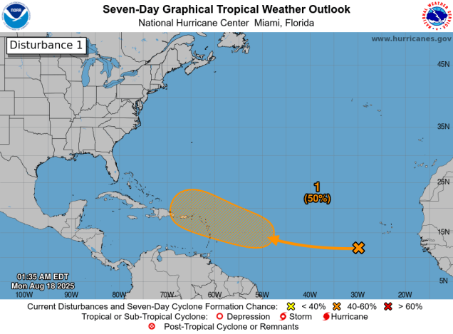
Now we’ll talk about the tropics. As you may have seen from all the Facebook Forecasters out there, Major Hurricane Erin is going to wipe out the East Coast in about 10 days. Well, that’s what a few of the models have shown at times over the past several days, and since the models show it, that’s what’s going to happen, because the models are always spot on 10 or more days in advance, right? Now, we’ll give you some real data. There is a strong tropical wave that moved off the west coast of Africa a few days ago. It has been fighting off some dry air and is over water that isn’t quite warm enough to sustain a tropical system, but it has shown some signs of organization in the past day or so. In fact, by the time some of you read this the National Hurricane Center may have already declared the system Tropical Depression 5. It will pass close to or over the Cabo Verde Islands today and then head in a general westward direction, likely strengthening as it does. The strengthening should be slow and steady as the system spending the next 5 day or so over the open waters of the Atlantic, and it will probably get upgraded to Tropical Storm Erin over the next day or two. It could become a hurricane later this week or next weekend. At that point, it should be approaching the longitude roughly near the Lesser Antilles. Most (but not all) of the models show the system passing north of the Islands, but that does not mean they are safe yet. However, around that point is an important spot to watch what the storm is doing. Some models show it turning more toward the northwest or even north at that point and heading out to sea (though possibly threatening Bermuda), while other models show it continuing off toward the west-northwest or even west. This would increase the threat to the Bahamas (and possibly the Greater Antilles). Of course, this is all still a week away, at which point the average error in the models is several hundred miles, so this really is just pure speculation. We won’t even get into how strong it might be, as intensity forecasts in the models are notoriously poor. For now, we’ll just say that it’s something to keep an eye on, but don’t worry about yet. *IF* it were to become a threat to the East Coast (and that’s a very big IF), we’ll give you plenty of advance notice. We’re not here for hype or page clicks (like the Facebook Forecasters), we’re here to give you a true look at what’s going on. We’ll likely be writing special blogs about this system (and the rest of the tropics) at various times this week. For now, ignore the noise, and listen to a trusted source, not one that picks out the scariest looking forecast model for 10 days from now and insists that is exactly what is going to happen (because it almost certainly won’t).
There’s still a wide range in model solutions for where the tropical system will track over the next 7 days. Image provided by Tomer Burg.
Monday: Sunshine and a few clouds. High 88-95, a little cooler along the coast.
Monday night: Clear skies. Low 65-72.
Tuesday: Plenty of sunshine. High 90-97, cooler along the coast.
Tuesday night: Clear to partly cloudy. Low 65-72.
Wednesday: Sunshine gives way to increasing afternoon clouds, chance for a late-day shower or thunderstorm, humid. High 86-93, cooler along the coast.
Wednesday night: Partly to mostly cloudy. Low 67-74.
Thursday: Partly sunny, showers and thunderstorms possible in the afternoon. High 83-90, cooler across the South Coast and Cape Cod.
Thursday night: Becoming clear. Low 62-69.
Friday: Sunny, drier. High 78-85, coolest near the coast.
Saturday: More sunshine. High 81-88, a little cooler along the coast.
Sunday: Mostly sunny. High 86-93, cooler along the coast.