Weekly Outlook: February 24 – March 2, 2025

Mostly dry and milder weather is expected to continue across the region for the next few days.

Temperatures will be several degrees above normal this week. Image provided by Weathermodels.com

We start the week off with high pressure moving offshore, allowing for another dry day with temperatures likely topping 40 in many areas. Even milder temperatures are expected on Tuesday ahead of a weak frontal system, which may produce a few widely scattered showers, but most of us will remain dry. Wednesday should be another dry day with temperatures a few degrees cooler. Thursday looks to be the mildest day of this stretch with well above normal temperatures, but it comes at a price. We’ll have a cold front approaching, and it will produce scattered showers across the region, possibly mixed with wet snow if they move in before daybreak. Temperatures start to fall behind it in the evening, so any untreated surfaces could ice up – keep that in mind if you’re heading out Thursday night. Drier and colder air settles in for Friday, though a few widely scattered rain or snow showers can’t be ruled out. As for next weekend, it looks like another low pressure system will move in, but the models don’t agree on much with this system right now, including the timing, amount of precipitation, and type of precipitation to expect. For now, this doesn’t look like it’ll be a potent system, but obviously we’ll keep an eye on it as the week goes on.

A storm system may impact the region later Saturday, but the details are still fuzzy. Images provided by Pivotal Weather.

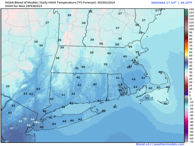
Monday: Morning sunshine with afternoon clouds. High 38-45.

Monday night: Partly to mostly cloudy. Low 30-37.

Tuesday: Mostly cloudy, slight chance for a late-day shower. High 44-51.

Tuesday night: Slight chance for an evening shower, then becoming partly cloudy. Low 29-36.

Wednesday: Mostly sunny, clouds start to move in late in the day. High 43-50.

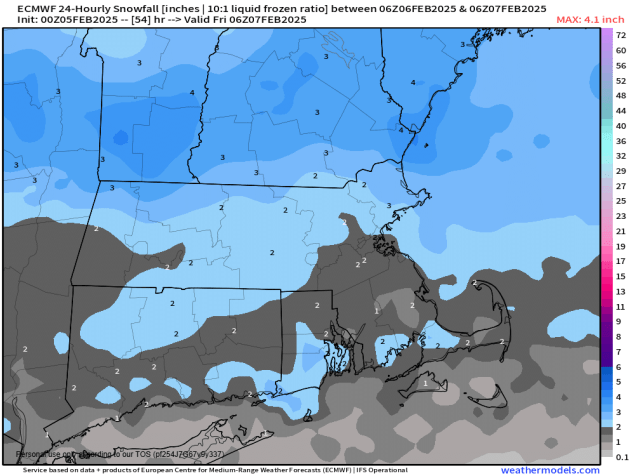
Wednesday night: Becoming mostly cloudy, some snow or rain showers possible before daybreak. Low 27-34.

Thursday: Plenty of clouds with occasional showers, breezy. High 46-53.

Thursday night: Mostly cloudy, showers gradually ending. Low 29-36.

Friday: A mix of sun and clouds, chance for a few snow or rain showers, breezy, and cooler. High 38-45.

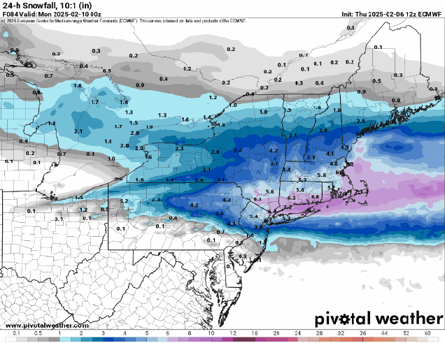
Saturday: Some early sun, then becoming mostly cloudy with light snow or rain possible during the afternoon and evening, breezy. High 35-42.

Sunday: Intervals of clouds and sunshine and light snow or rain ending, breezy. High 33-40.

Weekend Outlook: February 21-24, 2025

A much quieter weather pattern is expected for the next few days.

A little snow is expected across Cape Cod and the Islands tonight. Image provided by WeatherBell.

A storm system will pass well offshore tonight, but close enough for some light snow and snow showers across Cape Cod and the Islands, and maybe a few flurries into southeastern Massachusetts. Parts of the Outer Cape and Islands could see an inch or two, but otherwise, this is not a problem for most of the region. The system pulls away Friday and high pressure builds in with sunshine along with breezy conditions. This won’t be a repeat of Monday with strong winds and cold temperatures, but it will be a breezy day. Winds will die down Friday evening, setting up a chilly night. A weak upper-level disturbance brings in some clouds later Saturday, but other than a few flurries, we’ll stay dry. Temperatures will slowly moderate over the weekend with high pressure in control. We’ll see more clouds on Monday as another system heads our way, but any rain or snow showers will hold off until nighttime.

Temperatures could top 40 across much of the region on Monday. Image provided by weathermodels.com

Thursday night: Mostly cloudy, light snow or snow showers across Cape Cod and the Islands, a coating to 2 inches possible, a few flurries across southeastern Massachusetts, some clearing late at night. Low 12-19.

Friday: Becoming partly to mostly sunny, breezy. High 25-32.

Friday night: Clear skies. Low 8-15.

Saturday: Sunshine and some late-day clouds. High 29-36.

Saturday night: Partly to mostly cloudy, chance for a snow flurry. Low 15-22.

Sunday: Partly sunny. High 34-41.

Sunday night: Partly to mostly cloudy. Low 17-24.

Monday: Intervals of clouds and sun. High 37-44.

Weekly Outlook: February 17-23, 2025

The pattern will turn less active for much of the week across the region.

Winds could gust in excess of 50 mph across the region today. Image provided by WeatherBell.

The storm that brought a variety of weather to the region on Sunday will move into Atlantic Canada today where it will slow down and continue to strengthen. It will continue to produce strong winds across the region into Tuesday, but today is when they will be strongest, with gusts upwards of 50-60 mph possible this afternoon. High Wind Warnings and Wind Advisories are in effect for nearly all of the region. We’ll see only a few breaks of sun today, but they should be more common on Tuesday as high pressure tries to start to build in. It will do so on Wednesday with more in the way of sunshine, and less in the way of wind. Clouds move back in late in the day ahead of a low pressure system moving off the Southeast coast. There is still some uncertainty with the track this storm will take, but it looks like it will stay far enough to the south to spare us from a major snowstorm. However, there is still a chance for some light snow, especially south of Boston, on Thursday. How far north the snow gets and how much falls will be determined by the exact track the storm takes. We may write a special blog about the storm on Wednesday, if needed. After that, high pressure builds in for Friday and the weekend with dry and chilly weather once again.

For now, it looks like a potential storm system on Thursday will stay mainly south of the region. Images provided by Pivotal Weather.

Monday: Intervals of clouds and sunshine, windy. High 22-29, wind chill 10-15 in the afternoon.

Monday night: Becoming clear to partly cloudy, windy. Low 8-15, wind chill 0 to -10 overnight.

Tuesday: Sunshine and some afternoon clouds, still windy. High 18-25, wind chill 5-10 in the afternoon.

Tuesday night: Becoming clear with diminishing winds. Low 5-12, wind chill 0 to -10 overnight.

Wednesday: Sunny in the morning, then clouds start to move in during the afternoon. High 23-30, wind chill 15-20 in the afternoon.

Wednesday night: Partly to mostly cloudy. Low 6-13.

Thursday: Mostly cloudy with a chance for some light snow, mainly south of Boston. High 25-32.

Thursday night: Any snow ends in the evening, becoming partly cloudy late at night. Low 15-22.

Friday: Partly to mostly sunny, breezy. High 28-35.

Saturday: Sunshine and some afternoon clouds. High 29-36.

Sunday: A mix of sun and clouds. High 31-38.

Weekend Outlook: February 14-17, 2025

Another messy storm is heading our way for the weekend.

A complex storm will bring a variety of weather to the region this weekend. Loop provided by Pivotal Weather.

The system that brought us a mix of snow, sleet, freezing rain and rain earlier today will pull away and high pressure builds in with clearing and colder weather tonight into Friday. If you’re heading out this evening use caution as any untreated surfaces may ice up pretty quickly. Clouds start to move back in Friday night as another storm heads our way, and this one looks quite complicated.

Many of the models show the potential for a significant ice storm across the interior this weekend. Images provided by Pivotal Weather.

Low pressure will move out of the Ohio Valley and head towards New England. We’ll see snow developing ahead of the storm Saturday afternoon, continuing into the evening hours. However, warmer air will start to move in aloft, with snow changing to sleet and freezing rain by early Sunday, and eventually plain rain along the South Coast and into parts of Southeastern Massachusetts and Rhode Island. A secondary area of low pressure will then develop, and pass right across southern New England, while what’s left of the original system crosses Northern New England. The question becomes, how far north does the warmer air get, both aloft and at the surface. The warmer air aloft may get as far north as central portions of Vermont and New Hampshire, resulting in snow changing to sleet and freezing rain. Before the changeover takes place, we could be looking at 2-4″ of accumulation south of the Mass Pike (less near the South Coast), with 3-6″ to the north, possibly more across southern New Hampshire if the changeover is a little slower to occur. At the surface, the cold air may remain locked in across most of New Hampshire, Vermont, and Maine, and even interior portions of southern New England, with temperatures not getting above freezing. As a result, we could be looking at a significant ice storm, especially from the hills of northern Rhode Island and northeastern Connecticut, across central Massachusetts and into much of southern New Hampshire, away from the Seacoast. Across eastern Massachusetts, temperatures may be warm enough for just plain rain for the bulk of the storm after the initial burst of snow. as the storm pulls away, some colder air may move back in, allowing for the precipitation to possibly change back to snow before ending Sunday night, then high pressure builds in with cold and dry conditions on Monday.

Light to moderate snow accumulations are expected, but that’s not the biggest concern with this storm. Image provided by Weathermodels.com.

Thursday night: Clearing, breezy. Low 18-25.

Friday: Sunshine and a few afternoon clouds, breezy. High 26-33.

Friday night: Increasing and thickening clouds. Low 9-16.

Saturday: Cloudy with light snow developing in the afternoon. High 25-32.

Saturday night: Snow changing to sleet and freezing rain, possibly all rain near the South coast. Low 21-28, temperatures start rising after midnight.

Sunday: Sleet and freezing rain across the interior, rain inside of 495 and south and east of I-95, possibly changing back to snow late in the day, breezy. High 27-34 north of the Mass Pike, 35-42 south of the Pike.

Sunday night: Snow or rain ending before midnight, some gradual clearing late at night, breezy. Low 15-22.

Monday: Partly sunny, windy, colder. High 25-32.

Weekly Outlook: February 10-16, 2025

The active pattern will continue for most of the week with a few more chances for wintry weather.

Sunday’s storm dropped 3-7 inches of snow across the region. Image provided by the National Weather Service office in Norton, MA.

We’re starting the week out with high pressure in control, giving us sunshine and chilly conditions today. Many places will get above freezing allowing for snow to melt, but as temperatures drop this evening, icy conditions will likely develop on untreated surfaces, so keep that in mind if you are heading out this evening. Clouds will start to move in on Tuesday ahead of another low pressure system. This one will bring snow into the Mid-Atlantic states, but likely passes well south of New England. However, the precipitation field surrounding the storm could get far enough north Tuesday night to bring a little light snow into the South Coast, Cape Cod, and the Islands, possibly as far north as parts of Rhode Island and southeastern Massachusetts. We’re not looking at much snow, just a dusting to perhaps an inch, so it’ll be more of a nuisance than anything else if it happens. High pressure brings drier air in for Wednesday, then things get complicated.

Some “nuisance snow” is expected near the South Coast Tuesday night. Image provided by WeatherBell.

Low pressure will move into the Great Lakes late Wednesday, then into the St. Lawrence Valley Wednesday night and Thursday. We’ll see snow developing ahead of the system Wednesday night, but as warmer air moves in aloft, a change to sleet and then freezing rain is likely. The question becomes – does a secondary area of low pressure develop and pass south of New England early Thursday? If it does, that will keep the cold air in place in the surface, resulting in sleet and freezing rain continuing across the interior, with a change to plain rain south of the Mass Pike. If it doesn’t, then the warmer air eventually moves in at the surface, with a change to plain rain across most of the region before the precipitation ends by midday Thursday. High pressure builds in with drier air for Friday and the first part of Saturday before things get complicated once again.

The models all have different ideas about what will fall from the sky on Thursday. Images provided by Pivotal Weather.

Another low pressure system will move out of the Great Lakes and into the St. Lawrence Valley later Saturday and Saturday night. We’ll see snow developing late Saturday, likely changing to rain at night. This time, we likely will see a secondary low pressure area develop, but the question is, where does it track. Does it pass south of the region, allowing some colder air to move back in with a change back to sleet or snow? Does it move right across the region, resulting in more rain for much of Sunday? At this point, it’s far too early to try and pin down these type of details, but it does look like, for now at least, that Sunday won’t be a nice day around here.

The models don’t agree on what will happen on Sunday either. Images provided by Pivotal Weather.

Monday: Partly to mostly sunny. High 28-35.

Monday night: Clear to partly cloudy. Low 7-14, north of the Mass Pike, 15-22 south of the Pike.

Tuesday: Morning sun, then increasing clouds. High 28-35.

Tuesday night: Mostly cloudy, chance for a little light snow near the South Coast, Cape Cod, and the Islands. Low 9-16 north of the Mass Pike, 17-24 south of the Pike.

Wednesday: Intervals of clouds and sun. High 26-33.

Wednesday night: Cloudy with light snow developing, changing to sleet and freezing rain late at night, possibly all rain south of Boston. Low 18-25, temperatures start rising after midnight.

Thursday: Snow, sleet, freezing rain, or rain ending by midday, some clearing towards evening. High 36-43.

Thursday night: Becoming partly cloudy. Low 16-23.

Friday: Mostly sunny, breezy, colder. High 25-32.

Saturday: Becoming mostly cloudy, light snow developing in the afternoon, changing to rain at night. High 29-36.

Sunday: Cloudy and breezy with rain likely, possibly changing back to sleet, freezing rain, or snow, especially north and west of Boston. High 35-42.

A Saturday Night Special

Another snowstorm is on the way for most of the region this weekend.

The active pattern that meteorologists have been talking about for a while has arrived, and the next snowstorm will impact the region this weekend. A low pressure system will develop in the Southern Plains later today and head toward the Tennessee Valley. A secondary low pressure system will likely develop off the Mid-Atlantic coastline late Saturday, passing south of New England Saturday night and early Sunday before pulling away. Snow will move into the region from southwest to northeast Saturday evening, and it could be moderate at times overnight Saturday night into Sunday morning. Snow should wind down and end around midday Sunday. We should have enough cold air in place for the precipitation to fall as all snow for most of the region, except possibly right along the South Coast and across parts of Cape Cod and the Islands.

Low pressure will pass south of the region early Sunday spreading in some snow. Loop provided by Tropical Tidbits.

With a track south of New England, right now it looks like the steadiest and heaviest snow will mainly be south of the Mass Pike, but this is obviously dependent on the track. A track a little farther to the south means even less snow across southern New Hampshire and northern Massachusetts, while a track a little farther north brings the heavier snow a little farther north, but also the chance for some rain to mix in a little farther inland near the South Coast. With the storm moving relatively quickly, we’re not expecting any widespread heavy amounts, but there could be a period very early Sunday where the snow falls moderate to heavy at times.

Snowfall totals won’t be exceptionally heavy from this storm. Image provided by WeatherBell.

By the time everything winds down around midday Sunday, we’re looking at a general 4-8 inches across most of the region, with a few heavier amounts possible, especially south of the Mass Pike. Obviously if there’s some rain mixed in near the South Coast this will keep amounts down a little.

The ECMWF Ensemble shows the potential for well-above normal precipitation from the Tennessee Valley to Southern New England over the next 10 days. Image provided by Weathermodels.com.

That’s not the end of the pattern though – we’re only just getting started. We’ll go into more detail in our Weekly Outlook Monday morning, but there could be additional storms impacting our region Tuesday night into Wednesday, Wednesday night into Thursday, and again next weekend (and possibly more beyond that). Obviously, it is way too early for any specifics with these storms, including whether they will actually impact us or not, but the potential is there for a very wintry February.

Weekend Outlook: February 7-10, 2025

As one storm ends, we look ahead to another one on the way for the weekend.

Most of Southern New England is under a Winter Storm Watch for Saturday night and Sunday morning. Image provided by the National Weather Service Office in Norton, MA.

Low pressure pulls away from the region tonight and high pressure builds in, with clearing skies along with breezy and chilly conditions. The high will remain in control into Saturday, with diminishing winds Friday night, resulting in a rather chilly night. Clouds start to move back in later Saturday as another low pressure system heads our way. Unlike today’s storm, this one will be a little colder, and have a little more moisture to work with, so we’re looking at mostly snow for a good chunk of the region, possibly a little rain across the South Coast and Cape Cod. The snow will likely start around midnight Saturday night, give or take an hour or two, and continue into Sunday afternoon before winding down. This will not be a blockbuster snowstorm, but light to moderate amounts are likely. We’ll have another post tomorrow with a more detailed look at the storm, but our preliminary thoughts on accumulations are 4-7″ for most of the area. We’ll clear out Sunday night behind the storm, then high pressure builds back in for Monday. Our active weather pattern will continue into next week with more storm systems heading our way. More details on that in our Weekly Outlook early Monday.

Our preliminary forecast of 4-7″ falls in line with what most of the models show right now. Images provided by Pivotal Weather.

Thursday night: Mostly cloudy, some clearing late at night. Low 25-32, temperatures may rise a little overnight.

Friday: A mix of sun and clouds, breezy. High 33-40.

Friday night: Clear to partly cloudy. Low 14-21.

Saturday: Some morning sun, then increasing and thickening clouds. High 28-35.

Saturday night: Cloudy with snow developing around midnight. Low 19-26.

Sunday: Snow ending by early afternoon, some late-day clearing. High 28-35.

Sunday night: Becoming clear. Low 7-14.

Monday: Mostly sunny. High 26-33.

Midweek Mess On the Way

We’re in an active weather pattern with a storm that will produce a messy Thursday, and another one expected over the weekend.

Most of Southern New England is under a Winter Weather Advisory for Thursday. Image provided by the National Weather Service Office in Norton, MA.

We’ve got high pressure in control today with sunshine and chilly temperatures, but a low pressure system over the Tennessee Valley will send clouds in tonight as it heads our way. We’ll see a secondary area of low pressure develop off the North Carolina coast and head northeastward, passing very close to or across the South Coast of New England on Thursday. With the cold air in place, precipitation will start as all snow near or just after the morning commute on Thursday. However, warmer air will begin to move in aloft at first, and eventually at the surface, which will result in quite a mess during the afternoon. South of the Mass Pike, we’re looking at a brief change to sleet before it goes over the plain rain during the afternoon. North of the Mass Pike is where we will have some issues. A change to sleet and freezing rain is likely, resulting in slippery travel on untreated roads. North of Manchester, NH, precipitation may stay all snow. Everything should wind down during the evening, but that means the evening commute, especially from I-495 and points north and west, could be very hazardous.

A messy storm is on the way for Thursday morning and afternoon. Loop provided by Tropical Tidbits.

How much snow are we expecting? To be honest, not a lot. South of the Mass Pike, we’re looking at 1-2 inches. For MetroWest, the North shore, the Merrimack Valley, and over into the hills of Worcester County, 1-3 inches. For Southern and Central New Hampshire, 2-4 inches. Again though, it’s the freezing rain late in the day that will have as big or a bigger impact by late afternoon.

Snowfall totals on Thursday will be fairly light for most of the region. Image provided by Weathermodels.com

Once we get past that, we’ve got another storm on the horizon for the weekend. This one looks to be mostly Saturday night and Sunday morning, and could be fairly similar to tomorrow’s storm. However, it will likely be a few degrees cooler, and contain more moisture, so we could be looking at a moderate snowstorm around here. We’ll get into more details on this storm in our Weekend Outlook tomorrow afternoon.

The potential exists for some moderate snow Saturday night and Sunday, especially north of the Mass Pike. Image provided by WeatherBell.

The active pattern will continue into next week, with another storm possible towards mid-week, but we’ll worry about that one later, as it is far too early to get into any specifics.

Weekly Outlook: February 3-9, 2025

Happy Truck Day to all who celebrate. While it’s a sign that Spring is on the way, Mother Nature won’t be providing too many other signs of Spring this week.

The first sign of spring is upon us – Monday is Red Sox Truck Day, when all of the equipment gets loaded up and shipped down to Fort Myers for spring training. Image provided by Boston.com

We’re starting the week off on a mild note. The low pressure system that brought us some light snow and rain will drag a warm front through this morning, allowing milder air to flow into the region on south to southwest winds. We’ll see some limited sunshine, but if it ends up being more widespread than we expect, temperatures could jump into the 50s. A cold front moves through tonight, possibly producing some rain showers in a few spots. High pressure builds in behind the system with sunshine accompanied by breezy and cooler conditions on Tuesday. The high will remain in control on Wednesday keeping us seasonably chilly, but clouds will start to stream in during the day ahead of the next storm system. There is a bit of uncertainty with this system, but we’ll likely see some snow developing across the region before daybreak on Thursday. A change to rain is likely south of the Mass Pike, but it’s the area from the Pike northward into southern New Hampshire that is a big question mark. Warmer air will likely move in aloft, allowing for a change to freezing rain and sleet, but how far north does the warmer air get at the surface? Some models bring it all the way into southern New Hampshire with a change to plain rain, some keep the colder air locked in at the surface, with the wintry mix and resulting hazardous travel conditions continuing into the afternoon, and some even keep it all snow across parts of southern New Hampshire and even northern Massachusetts. It’s a little too early to decide which way to lean with this, so we’ll continue to monitor it, and if there is enough of a threat of wintry weather, we’ll write a separate blog about it on Wednesday.

Right now the models all have different ideas about Thursday storm system Images provided by Pivotal Weather.

The precipitation winds down later Thursday as the system moves offshore, then high pressure builds in for Friday and Saturday with dry and colder weather. The next system heads out way for late Saturday into at least part of Sunday. This one looks a little colder, with snow becoming a better bet across much of the region, though the South Coast and Cape Cod may see some rain. This system also looks to contain a little more moisture so there is the potential for a decent-sized storm, especially across the interior, but this is still nearly a week away, so things can and will change numerous times between now and then. We’ll have more details on this system in our Weekend Outlook on Thursday, but we wanted to give you plenty of heads up on this one, since a lot of people tend to travel to parties on Super Bowl Sunday.

The models aren’t on the same page for Saturday night and Sunday either. Images provided by Pivotal Weather,

Monday: Becoming partly sunny. High 38-45.

Monday night: Mostly cloudy, chance for a few showers, some clearing late at night. Low 29-36.

Tuesday: Partly to mostly sunny, breezy, and colder. High 34-41 in the morning, temperatures drop in the afternoon.

Tuesday night: Clear to partly cloudy. Low 10-17.

Wednesday: A mix of sun and clouds. High 24-31.

Wednesday night: Becoming cloudy, snow developing late at night, possibly some rain near the South Coast and Cape Cod. Low 12-19 during the evening, temperatures start rising after midnight.

Thursday: Cloudy and breezy with snow changing to rain from Mass Pike southward, snow may change to sleet, freezing rain or plain rain north of the Mass Pike. Precipitation ends late in the day. High 36-43.

Thursday night: Gradual clearing, breezy. Low 25-32.

Friday: Partly to mostly sunny, breezy. High 34-41.

Saturday: Morning sun gives way to increasing afternoon clouds, snow may develop late in the day or at night. High 29-36.

Sunday: Cloudy with a chance of snow or rain. High 35-42.

Weekend Outlook: January 31 – February 3, 2025

An active weather pattern will continue through the weekend but our first signs of Spring will also show up.

We’re still in a drought and need all the rain (and snow) we can get. Image provided by the National Drought Mitigation Center.

Clouds will stream into the region tonight ahead of a low pressure area moving into the Ohio Valley. A warm front ahead of the system will move in on Friday, with some rain developing ahead of it, though there may be enough cold air in place for a little freezing rain or snow as you get into parts of central and southern New Hampshire at the start. Much of the afternoon will feature some light rain and mild temperatures, but as the system passes by, colder air will start to work its way in, with rain changing to snow across southern New Hampshire during the evening, with the rain/snow line likely getting down to the Mass Pike before the precipitation ends a little after midnight. We’re not expecting much accumulation, just an inch or two, mainly north of Route 2. The bigger issue might be icy conditions developing on the roads. Temperatures will drop below freezing during the overnight, and the roads will still be wet from the rain, so they could ice up pretty quickly once the rain changes over, and before road crews have a chance to treat the roads. Keep this in mind in you will be out late Friday night.

We’re not expecting much snowfall accumulation from the Friday night system. Image provided by WeatherBell.

High pressure builds in for Saturday with sunshine and colder conditions, but it will be short-lived. Clouds come right back in by Sunday morning as an Alberta Clipper makes its way across southern Canada. We’ll see this system spread in some light snow Sunday evening and night, but again, we’re not expecting more than an inch or two, and again it will be mainly north of the Mass Pike. In fact, there may not be any precipitation from this system south of the Pike. The snow ends Monday morning, then we’ll turn partly sunny and rather milder for the afternoon. However, a cold front trailing the system will move in by late in the day, possibly producing a few more rain showers.

Sunday night’s system will not produce a lot of snow across the region. Image provided by Weathermodels.com.

We also have two signs that Spring is nearly here coming this weekend. First, Sunday is Groundhog Day. According to tradition, if the groundhog emerges from its burrow and sees its shadow, and will go back inside and winter will last for 6 more weeks. If it doesn’t see its shadow, spring will arrive early. The most famous celebration of this day takes place in Punxsutawney, PA, where Punxsutawney Phil is brought out every year. He has only seen his shadow 20 times in the 138 years this has been recorded. Secondly, Monday is Truck Day. That is the day the Red Sox equipment truck gets loaded up at Fenway Park and begins the drive southward to Fort Myers, Florida. Pitchers and catchers will have their first workout of Spring Training on February 12.

One of the first signs of spring is upon us – Monday is Red Sox Truck Day, when all of the equipment gets loaded up and shipped down to Fort Myers for spring training. Image provided by Boston.com

Thursday night: Becoming mostly cloudy. Low 17-24 during the evening, temperatures start rising after midnight.

Friday: Cloudy with rain developing by early afternoon, possibly mixed with a little freezing rain or snow across central and southern New Hampshire at the start. High 37-44.

Friday night: Mostly cloudy with rain changing to snow from north to south during the evening, ending shortly after midnight. Low 24-31.

Saturday: Becoming partly to mostly sunny, breezy, and colder. High 30-37.

Saturday night: Clear during the evening, clouds start to move back in after midnight. Low 4-11.

Sunday: Becoming cloudy, some light snow or snow showers may develop by evening. High 28-35.

Sunday night: Cloudy with light snow or snow showers likely. Low 21-28 during the evening, temperatures rise overnight.

Monday: Plenty of clouds with some sunny breaks developing, a few rain showers possible late in the day, breezy. High 42-49.