Snow in the Forecast? Not for Most of Us

By now, you’ve probably heard from your favorite TV meteorologist that there’s snow in the forecast for Thursday. While parts of the region will likely see some snow on Thursday, the vast majority of us will not.

High pressure will provide us with some chilly weather for the next few days. Temperatures will likely dip near or below freezing across much of the area tonight and again Wednesday night. So, we’ve got cold air in place, and a storm system heading our way on Thursday. That means it’s going to snow, right? As famed college football analyst Lee Corso would say “Not so fast my friend”. Allow us to explain.

gfs_t2min_boston_9
Thursday morning will start off with temperatures below freezing across much of the region. Image provided by WeatherBell.

As that high pressure area moves off to the east, winds will shift into the east and southeast across the region. Water temperatures off the coast are still in the 50s to lower 60s, so a wind off the water will allow temperatures to moderate. Thursday will still be a chilly day, with temperatures mainly in the 40s, but the air will remain dry, thanks to the high pressure area. As the precipitation arrives from the west during the afternoon, it will fall into that dry air, evaporating before it hits the ground. This will also allow temperatures to drop through a process called evaporational cooling. Temperatures may drop into the upper 30s to lower 40s before the air moistens up enough for the precipitation to hit the ground.

qpf_acc-us_ne
GFS model forecast for rainfall through Friday afternoon. Image provided by Pivotal Weather.

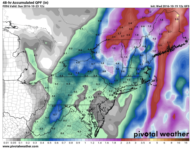
With temperatures likely near or just above 40, we’re looking at mainly rain across most of our region. Oh sure, there could be a renegade snowflake or ice pellet mixed in at the start across parts of southern NH or central MA, but for the most part, we’re looking at rain, and possibly a decent amount of it. Much of the region could receive between 0.75″ and 1.50″ of rain from this system, which will help put a dent into the ongoing drought.

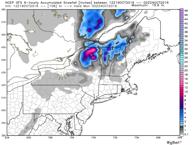
Farther to the north and west, especially across the higher elevations of the Berkshires, Monadnocks, and the mountains of Northern New England, temperatures will be cooler, and the precipitation will arrive faster, thus increasing the chances that it starts as snow. Even in these locations, warmer air will move in Thursday night, allowing the snow to change over to rain. Before that happens, we could see a little accumulation, especially at the higher elevations, where a few inches may accumulate. The best chance for accumulating snow actually looks to be across the Adirondacks of northeastern New York, where the warm air will have a tough time getting in.

gfs_6hr_snow_acc_neng_13
Snowfall forecast from the GFS through Friday morning. Image provided by WeatherBell.

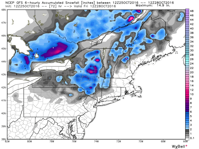
Once we get past this system, we could be looking at a wet weekend and start of next week. A couple more storms may move across the region, bringing us several bouts of much-needed rainfall. It does not look like there will be more snow with these systems, except possibly across the mountains of northern New England.

A Little Bit of Everything – October in the Northeast

October can be a time of change in the Northeast. While the first thing that comes to mind is the changing colors of the foliage across the region, the weather also changes, sometimes quite frequently. That’s what we’re going to be dealing with for the next few days.

rtma_t2m_neng
Current temperatures across the Northeast as of 1pm on October 19. Image provided by WeatherBell.


It’s an unseasonably warm afternoon across much of the Northeast, with temperatures generally in the 60s and 70s, with 80s from southern Connecticut into the Mid-Atlantic states. Dozens of record highs have been set over the past few days, and more are falling today. However, some changes are coming, and the warm weather will be a distant memory within the next 24-48 hours.

A cold front is moving across the region this afternoon, though you really couldn’t tell, as there’s only scattered cloud cover and little precipitation with the front. That front will stall out to the south of New England tonight. On Thursday, a wave of low pressure will start to approach from the west. This will spread rain and showers into the region. Some of the rain will be heavy, especially from New York into Pennsylvania late Thursday into Friday. With rainfall totals of 1-3 inches and locally up to 5 inches expected, some flooding is likely. Across New England, where a serious drought is ongoing, rainfall will be much lighter, with most locations likely receiving under half an inch of rain.

qpf_acc-us_ne
Expected rainfall through Friday evening across the Northeast. Image provided by Pivotal Weather.


As that wave of low pressure moves into Upstate New York on Friday, it will lift that cold front back across New England as a warm front. While Friday won’t be as warm as today, temperatures will still get into the 60s and lower 70s across much of New England. With dewpoints also in the 60s, it will be a rather muggy day for mid-October.

99l_tracks_latest
Computer model forecasts for the track of a tropical disturbance in the Bahamas. Image provided by Tropical Tidbits.


Meanwhile, there is a tropical disturbance brewing in the Bahamas right now. While conditions are favorable for development, we’re not looking at another monster like Matthew, it could become a tropical depression or subtropical storm over the next few days. The system will likely head northward, moving towards the Gulf of Maine as we head into the weekend. This will bring another round of heavy rainfall into Maine and Atlantic Canada, again missing most of Southern New England, where the rain is most needed.

qpf_048h-us_ne
Expected rainfall between Friday morning and Sunday morning across the Northeast. Image provided by Pivotal Weather.


Once the system moves into southeastern Canada, it is expected to stall out under an upper-level low pressure area and become a strong extratropical system. It will drag a cold front across the Northeast, bringing much colder air into the region. With strong low pressure nearby and much colder air filtering in, rain will change over to snow across portions of Upstate New York and Northern New England. While the snow will be confined mainly to the higher elevations, this is the first accumulating snow of the season across the area. Several inches may accumulate across parts of the Adirondacks and the Green Mountains.

gfs_6hr_snow_acc_neng_19
Expected snowfall through Sunday evening across the Northeast. Image provided by WeatherBell.


While there could be a few wet flakes mixed in with some of the rain across lower elevations of Central New England, accumulating snow is not expected.Sunday will be a chilly day, with highs only in the 40s and 50s across much of the Northeast. These readings are 10-20 degrees below normal. Of course, any mention of snow in October across the Northeast will make residents think back just a few years to the pre-Halloween snowstorm that dropped 1-2 feet of snow across parts of the region, setting numerous records. While this system won’t come anywhere close to that, it should make for some spectacular photos of snow-capped mountains and valleys filled with colorful foliage early next week.

20111029-20111030-1-75
Snowfall from the Halloween snowstorm of 2011. Image provided by NOAA.