Weekly Outlook: October 26-November 1, 2020

It’s coming. Most of you don’t want to hear it, but you’re going to anyways. No, we’re not talking about changing the clocks this coming weekend. We’re talking about something scarier that happens before that, and it’s not Halloween either. It’s the first mention of “snow” in the forecast.

Turn your clocks back an hour Saturday night before bed. We don’t want to know what you’re doing with your hoe for that extra hour. Image provided by Wikipedia.

We’ll start the week with a rather “blah” day. A warm front will try to lift northward into the region, but probably won’t make it (a sign of things to come this winter?). As a result, we’re stuck with plenty of clouds, some drizzle and/or showers, and cool temperatures. A cold front will move through at night, with a few more showers possible. Behind the front we’ll have a couple of drier days for Tuesday and Wednesday, but as little upper-level disturbances move through, we’ll still have some clouds and maybe a shower or two. With high pressure to the north, we’ll still have easterly winds, so it will remain on the cool side, with temperatures generally running a few degrees below where they should be in late October.

Average high temperatures in late October are in the upper 50s. Image provided by Weathermodels.com

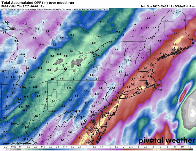
The end of the week is where things get interesting, complicated, and uncertain. A frontal boundary will remain stalled out south of the region keeping us cool. Meanwhile, what’s left of Tropical Storm Zeta will move across the Tennessee Valley and will likely ride along that boundary to our south. How far south that boundary lies will help determine how far north the rains from Zeta get. Thursday will be a cool, wet day obviously, but how wet remains to be seen. Some models are showing the potential for some heavy rainfall, especially along the South Coast, which would help somewhat with the drought, but also make the day even more miserable.

Some models show the potential for heavy rainfall this week while others show significantly less rain. Images provided by Pivotal Weather.

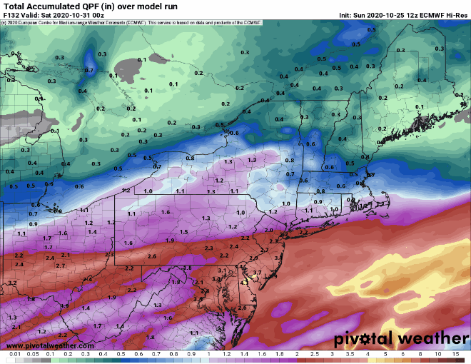
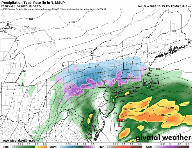
But wait, that’s not all. At the same time, an upper-level low will be moving out of the Plains and toward the Mid-Atlantic states, while another upper-level disturbance will be moving across the Great Lakes and towards New England. These two will help determine our weather for Thursday night and Friday. Some models show the potential for these two systems to join up or “phase”. This happens often during the winter to create some of our stronger storms. We’re not convinced that will happen here. Even if it does, it may not happen until the disturbances are past us, in which case, it won’t matter. Even if they don’t phase, we’re going to see colder air get drawn southward in the wake of Zeta’s remnants and as another low passes south of us. At the same time, we’ll have more precipitation moving in. So, while Friday will be another chilly and wet day, it’s becoming more likely that the rain will change over to wet snow in some of the hills from Worcester County into the Monadnocks, where there may even be enough to turn the ground white. For the rest of us, there are still too many variables to really be too definitive. We wouldn’t be shocked if some wet snow mixed in with the rain across parts of southern New Hampshire and eastern Massachusetts. There are some models that are forecasting accumulating snow around here. We can’t even rule that out, if everything lines up perfectly. We’re not expecting a repeat of “Snowtober”, but other than that, anything is possible.

The models still have a variety of solutions for Friday, leading to an uncertain forecast. Images provided by Pivotal Weather.

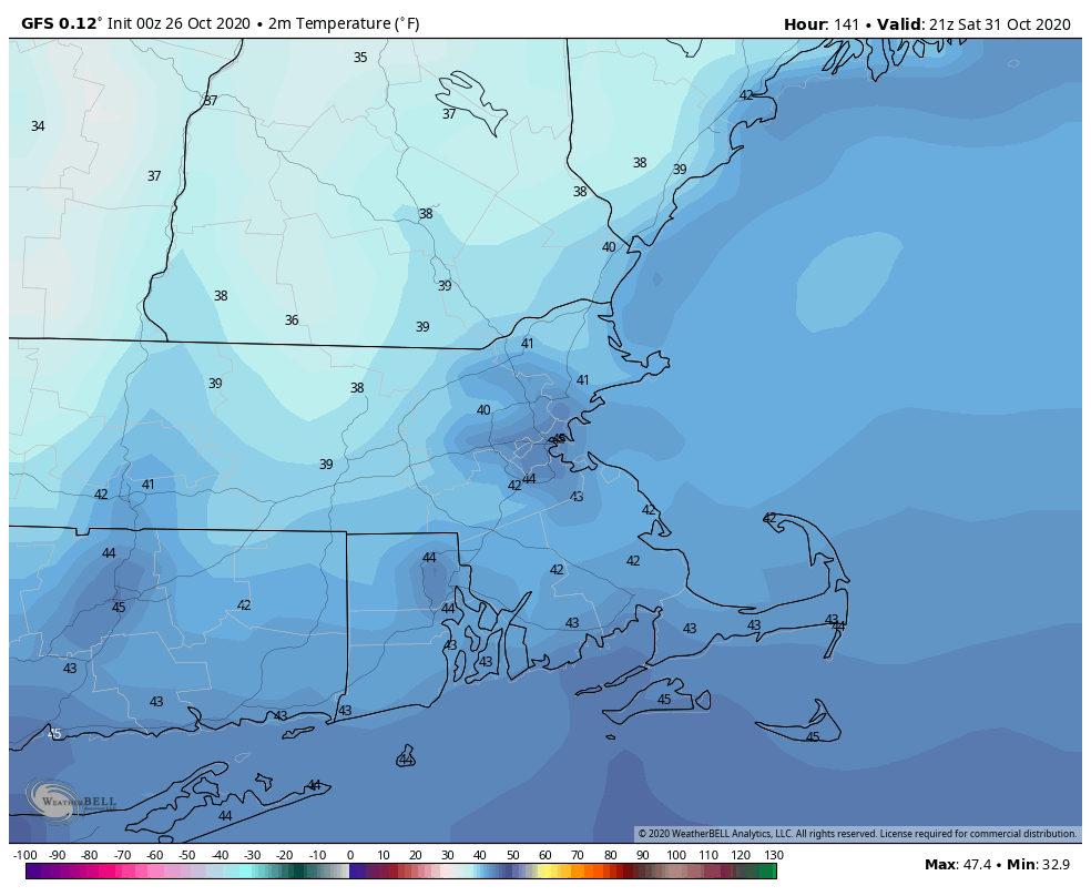
Once that system pulls away, high pressure builds in with sunshine and chilly temperatures for Halloween. Make sure the kids are bundled up if they are heading out to trick or treat, as it will be chilly Saturday evening. The high slides offshore on Sunday, allowing temperatures to moderate, but the next system will be quickly approaching, with some showers possible by evening.

Temperatures may only be in the lower 40s for Trick-or-Treat time Saturday evening. Image provided by WeatherBell.

Monday: Clouds, drizzle, fog, maybe a few showers. Blah. High 52-59.

Monday night: Cloudy with a shower possible. Low 44-51.

Tuesday: Clouds and some afternoon sunny breaks. High 52-59.

Tuesday night: Mostly cloudy. Low 33-40.

Wednesday: More clouds than sunshine, a few showers are possible. High 50-57.

Thursday: Cloudy with showers developing, possibly become a steady rain late in the day. High 50-57.

Friday: Cloudy and breezy with rain and showers possibly mixing with or changing over to some wet snow before ending in the afternoon. High 38-45.

Saturday: Plenty of sunshine. High 42-49.

Sunday: Some early sun, then clouds return with showers possible late in the day. High 51-58.

Weekly Outlook: October 19-25, 2020

Last week’s rainfall will help, but this week will bring little to no relief from the drought.

Most of New England received beneficial rainfall over the past week. Image provided by WeatherBell.

Much of the upcoming will will be dry across the region thanks to a large offshore high pressure area. That doesn’t mean it will be sunny every day, however. We’ll have a frontal system stalled out to our north and west for most of the week, with the high offshore preventing it from moving through. As waves of low pressure ride along the front, we’ll have some cloud cover, and a few stray showers may move in at times, especially Tuesday or Wednesday, but for the most part, it will remain dry.

Little to no rainfall is expected over the next week across the region. Image provided by Weathermodels.com

Although it won’t be completely sunny, it will be relatively warm for mid-October. We’ll have southwest winds bringing mild air in, with temperatures mainly in the 60s and 70s this week, which is 10 to 20 degrees above normal.

Well above normal temperatures are expected for most of the week. Image provided by WeatherBell.

By later Saturday, that cold front will finally have enough of a push to move through, but again, it won’t produce much in the way of rainfall, just a few showers. What will be noticeable is the cooler air settling in for next Sunday, bringing temperatures back where they should be for late October, maybe even a little below normal.

Monday: Sunshine filtered through some high clouds. High 58-65.

Monday night: Partly to mostly cloudy. Low 44-51.

Tuesday: Partly sunny, slight chance for a shower. High 64-71.

Tuesday night: Partly to mostly cloudy. Low 50-57.

Wednesday: Intervals of clouds and sunshine, chance for a shower or two. High 65-72.

Thursday: A mix of sun and clouds. High 67-74.

Friday: Partly to mostly sunny. High 61-68.

Saturday: Partly sunny, chance for a few showers late in the day and at night. High 63-70.

Sunday: A mix of sun and clouds, cooler. High 52-59.

Weekly Outlook: October 12-18, 2020

Some much-needed rainfall is finally on the way, but we need a lot more.

Drought conditions continue to worsen across New England. Image provided by the National Drought Mitigation Center.

The remains of Hurricane Delta will move into the Mid-Atlantic states today, bringing that region some more heavy rainfall. Some of that rain will get into southern New England today, but it doesn’t look like it will make too much progress northward, thanks to high pressure that will be slow to move out. Right out, it looks like most of the rain today will be south of a line that stretches from Hartford to Providence to Plymouth, or roughly south of Route 44. A few showers may get farther north, but the bulk of the rainfall should stay south during the daytime. With the high to the northeast and low pressure to the southeast, we’ll have brisk northeast winds resulting in a rather cool day across the region, with temperatures likely staying in the 50s for most of us.

Up to an inch of much-needed rain is expected with some spots possibly exceeding an inch. Image provided by WeatherBell.

As low pressure gets a little closer tonight and a cold front starts to approach from the west, rainfall should become more widespread across the region. Some of the rain may be heavy, and it may actually bring down some warmer air from aloft, allowing temperatures to rise a few degrees. The rain continues into Tuesday, which should be a bit milder, ending from west to east during the afternoon as the cold front moves across the region.

High pressure builds in for Wednesday and Thursday, bringing some sunshine and milder weather back in. However, our dry and mild weather will be short-lived. Another cold front approaches on Friday, with another round of showers expected. Some of the models try to develop an area of low pressure along this front which would bring some heavier rain into the region, but we’re skeptical of that scenario at this point. Since the drought began in the Spring, we’ve seen numerous model forecasts for a decent amount of rain several days out that fizzle as it gets closer. Until we see something to change our mind, we’ll continue to lean towards lighter amounts of rain. (Even the rain for today/tomorrow was forecast to be much heavier by the models just a day or two ago) While we’re leaning dry, we are mindful of the fact that more than one model is going for the rain to last through Saturday and into early Sunday. In fact, one of the models actually has the rain change to snow across the mountains of northern New England this weekend as colder air moves in. Obviously, we should have much more clarity on the weekend forecast when we issue our Weekend Outlook Thursday afternoon, but we just wanted to warn you up front that although our forecast right now shows a decent weekend, that is subject to change.

With some sunshine, Friday could be quite warm ahead of a cold front. Image provided by Weathermodels.com

Monday: Cloudy, breezy, and cool with some showers likely, mainly close to the South Coast. High 51-58.

Monday night: Cloudy and breezy with more widespread showers and a period of steady rain, possibly heavy in spots. Low 46-53, but temperatures may drift up a few degrees after midnight, especially south of Boston.

Tuesday: Periods of rain and showers during the morning, ending from west to east during the afternoon. High 57-64, possibly a little warmer near the South Coast and Cape Cod.

Tuesday night: Gradual clearing. Low 44-51.

Wednesday: A mix of sun and clouds, milder. High 62-69.

Thursday: Partly to mostly sunny, breezy. High 65-72.

Friday: Plenty of clouds with some showers likely. High 65-72.

Saturday: Early clouds, then becoming partly sunny. High 56-63.

Sunday: A mix of sun and clouds. High 54-61.

Weekly Outlook: October 5-11, 2020

We’re not expecting much drought relief again this week, but it won’t be completely bone-dry either.

Most of the region has received 50-75% of the normal amount of rainfall over the past 6 months. Image provided by the Northeast Regional Climate Center.

The week actually starts off with low pressure passing south and east of the region this morning. It will produce some showers across the Cape and Islands, and possibly into parts of southeastern Massachusetts, but once you get north and west of Interstate-95, there won’t be any rain to be found. The system pulls away during the afternoon and high pressure builds in, with skies quickly clearing out. The high will slide offshore tonight, but another weak system will move through on Tuesday, with some more clouds and possibly a few brief showers.

Clouds become more numerous on Wednesday as low pressure heads into the St. Lawrence Valley. While it’ll be warmer, we’ll also have some showers to deal with, and possibly a rumble of thunder as well. The system will drag a cold front across the region Wednesday night, bringing an end to the shower activity.

As has been the case for quite some time, we’re not expecting much rainfall over the next ew days. Image provided by the College of DuPage.

Behind the front, gusty northwest winds will usher cooler air into the region on Thursday despite a decent amount of sunshine. As the winds start to die down Thursday night, we’ll have clear skies, setting up a very chilly night, with some places possibly getting down close to freezing. Friday will be another cool day despite ample sunshine, but then high pressure will slide offshore, resulting in a warming trend for next weekend.

Friday morning could be quite chilly across the region. Image provided by WeatherBell.

Monday: Cloudy during the morning with some showers south of Boston, becoming partly sunny in the afternoon. High 61-68.

Monday night: Clear skies, a little patchy fog is possible in a few spots. Low 45-52.

Tuesday: A mix of sun and clouds, chance for a few showers during the afternoon. High 62-69.

Tuesday night: Becoming mostly cloudy. Low 50-57.

Wednesday: Mostly cloudy and breezy with scattered showers developing, possibly a rumble of thunder. High 66-73.

Thursday: Sunshine and some afternoon clouds, breezy, and cooler. High 58-65.

Friday: Sunny and cool. High 52-59.

Saturday: Partly to mostly sunny, breezy, and milder. High 64-71.

Sunday: A mix of sun and clouds. High 69-76.

The tropics are getting active again. Image provided by the Canadian Hurricane Centre.

Finally, we’ll briefly mention the tropics. Tropical Storm Gamma will continue to produce heavy rain across the Yucatan Peninsula for a few more days as it drifts into the Bay of Campeche. Tropical Depression 26 will likely become Tropical Storm Delta today (it may already have done so by the time you read this). It will bring gusty winds and heavy rain to parts of Jamaica today, then the Cayman Islands and western Cuba over the next few days. It will then head into the Gulf of Mexico, and could threaten the central Gulf Coast later in the week as a hurricane. We’ll have a much more detailed post about the tropics later today or more likely on Tuesday.

Weekly Outlook: September 28 – October 4, 2020

As September ends and October begins, we’ve got some changes coming for our weather pattern.

We start the week off with warm and humid conditions that feel more like late summer than early fall. Thanks to high pressure off the East Coast, southerly flow will continue to pump warm and humid air into the region today and Tuesday. However, we’ll also have plenty of clouds, along with a few showers today and again on Tuesday as a couple of weak disturbances move across the region.

With a little bit of sunshine, temperatures could approach 80 in some spots on Tuesday. Image provided by Weathermodels.com

Tuesday night into Wednesday is when the bigger changes start to happen. A cold front approaches the region Tuesday night, moving through on Wednesday. A low pressure area will ride along this front, bringing in some showers. While the bulk of the activity, especially the heavy rain, looks like it will stay to our west, we will see some beneficial rain here, mainly Tuesday night into Wednesday morning. We may get a bit of a lull Wednesday afternoon and evening, but by Wednesday night, a low pressure area will move off the Mid-Atlantic coastline and head northeastward, passing near or just east of the Cape and Islands early Thursday.

Over the last 6 months, rainfall is generally 5-10 inches below normal across the region. Image provided by WeatherBell.

Some models are showing the potential for heavy rain across eastern New England with this system, but we’re a bit skeptical at this point. We’ve seen the models forecast significant rainfall around here numerous times in the past few months, and it just hasn’t materialized for the most part. Add in the fact that not all the models are showing the heavier rain getting in here, and the fact that even the ones that do haven’t been consistently showing it on every run, and we’ve got plenty of reasons to doubt it. Having said that, droughts don’t last forever, and it does have to start raining more consistently at some point, because this is New England, not Arizona.

The models mostly agree that we’ll have some significant rainfall this week, but they don’t agree on how much or where the heaviest rain will fall. Images provided by Pivotal Weather.

High pressure will try to build in for the end of the week and the weekend with cooler and drier conditions. However, an upper-level low will remain off to our west, and little impulses riding around that low may bring in some more clouds and possibly a few showers, mainly Friday, but possibly Saturday too. Beyond that, it looks like a cooler pattern sets up for next week. There are even a couple of models that show the potential for a storm late next week that may not produce just rain across the higher elevations of northern New England (We’ll be kind and refrain from using that 4-letter word that begins with S that many of you don’t like).

Temperatures may average below normal across the region next week. Image provided by WeatherBell.

Monday: Mostly cloudy with a few showers possible. High 74-81.

Monday night: Partly to mostly cloudy. Low 60-67.

Tuesday: More clouds than sunshine with showers possible late in the day, mainly north and west of Boston. High 73-80.

Tuesday night: Cloudy and breezy with showers likely. Low 62-69.

Wednesday: Cloudy and breezy with some showers around, becoming a steady rain at night. High 69-76.

Thursday: Rain ending early, some clearing in the afternoon. High 65-72.

Friday: A mix of sun and clouds, chance for a pop-up shower. High 62-69.

Saturday: Partly sunny, slight chance for a shower. High 61-68.

Sunday: Some sun early, clouds return in the afternoon. High 58-65.

Weekly Outlook: September 21-27, 2020

We’re starting to sound like a broken record, but little to no rainfall is expected again this week.

This week’s forecast is fairly simple, so we’ll keep it brief. Monday and Tuesday will feature dry and cool conditions with high pressure in control. Winds will pick up on Tuesday as the extratropical remains of Hurricane Teddy pass to our east and into Nova Scotia. It will create some very rough surf, so heading to the beach or out on a boat won’t be advisable until seas start to calm down later in the week.

Wave heights will be in excess of 40-50 feet east of the Cape and Islands by late Tuesday. Image provided by WeatherBell.

By Wednesday, the high slides offshore, and warmer weather settles in for Wednesday and Thursday. A weak disturbance crosses the region on Friday with some clouds and maybe a shower or two, but that’s about it. Dry weather returns next weekend.

Little to no rainfall is expected across the reion this week. Image provided by Weathermodels.com.

Monday: Sunshine and lots of it. High 59-66.

Monday night: Clear skies, though some high clouds may move into eastern areas late at night. Low 36-43, warmer in the urban areas and across the Cape Cod.

Tuesday: Sunshine filtered through high clouds, though some thicker clouds are possible across Cape Cod, becoming breezy, especially along the coast. High 63-70.

Tuesday night: Mostly clear. Low 49-56.

Wednesday: Partly to mostly sunny., breezy, and warmer. High 71-78.

Thursday: Sunshine and some afternoon clouds. High 72-79.

Friday: More clouds than sun with a chance for a few widely scattered showers. High 71-78.

Saturday: Plenty of sunshine. High 70-77.

Sunday: More sunshine. High 71-78.

Five Storms in the Atlantic

With the formation of Tropical Storm Vicky this morning, we now have a record-tying five storms in the Atlantic, and there may be another one coming soon.

The Atlantic remains active with 5 named storms this morning. Loop provided by NOAA.

The most immediate threat to the US is Tropical Storm Sally. Sally continues to slowly strengthen in the Gulf of Mexico. As of late Monday morning, Sally was centered about 185 miles southeast of Biloxi, Mississippi, moving toward the west-northwest at 6 mph. Maximum sustained winds were near 65 mph.

Forecast track for Tropical Storm Sally. Image provided by the National Hurricane Center.

Sally is expected to track northwestward across the northern Gulf of Mexico while strengthening later today into Tuesday. It will likely become a hurricane by tonight. Current forecasts call for landfall in either southeastern Louisiana or southern Mississippi on Tuesday. Hurricane and Storm Surge Warnings are in effect for much of the region. The location of landfall will have a significant impact on what conditions occur in some locations, namely storm surge. The highest storm surge is usually found near and to the right of where the center makes landfall. A landfall in southeastern Louisiana brings that storm surge to parts of the Louisiana coast and into Mississippi and Alabama. A track a bit farther east spares Louisiana from significant surge, but increases the threat to Mississippi, Alabama, and parts of the Florida Panhandle.

Significant storm surge is likely near and to the east of where the eye makes landfall.

While storm surge and strong winds are significant threats, rainfall will be the most significant issue residents of the Gulf Coast need to prepare for. Sally will be a slow-mover, and could even stall out near or just after landfall. We’ve seen plenty of slow-moving tropical systems dump torrential rainfall on places in recent years, and this system will likely do the same. Rainfall totals of 15-25 inches and possibly heavier will create widespread significant flooding. The heavy rain will also spread well inland, with flooding possible into parts of the Tennessee Valley later this week.

Torrential rainfall is likely along the Gulf Coast. Image provided by WeatherBell.

While Tropical Storm Sally is a threat to land, Hurricane Paulette impacted land earlier this morning, when it moved directly across the island of Bermuda. Paulette was centered about 65 miles north of Bermuda late this morning, moving toward the north at 14 mph. It has maximum sustained winds near 100 mph, and some additional strengthening is likely over the day or so as it turns more toward the northeast. Paulette is expected to head out into the open Atlantic over the next several days, presenting no additional threat to land.

Radar loop showing Hurricane Paulette approaching Bermuda Sunday night and early Monday. Loop provided by Brian McNoldy, Univ. of Miami, Rosenstiel School

In the central Atlantic, Tropical Depression Rene remains weak late this morning. It is centered about 1100 miles northeast of the Lesser Antilles, and maximum sustained winds have decreased to near 30 mph. Rene is expected to dissipate over open water in the next day or two.

Heading further eastward, we have Tropical Storm Teddy. As of late this morning, Teddy was centered about halfway between the Lesser Antilles and the Cabo Verde Islands. Maximum sustained winds were at 40 mph, and additional strengthening is likely. Teddy could become a hurricane by late Tuesday or Wednesday, and could strengthen into a rather potent storm by later this week. A turn toward the northwest should keep Teddy over open water, though residents of Bermuda should keep an eye on this storm, as it could present a threat to the island by late this weekend or early next week.

Forecast track for Tropical Storm Teddy. Image provided by the National Hurricane Center.

Even farther to the east, Tropical Storm Vicky developed this morning. As of late morning, Vicky was centered about 350 miles west-northwest of the Cabo Verde Islands, moving toward the northwest at 6 mph. Maximum sustained winds were near 45 mph. Vicky is expected to turn more toward the west over the next day or two while slowly weakening. It will likely dissipate over open water later this week.

Forecast track for Tropical Storm Vicky. Image provided by the National Hurricane Center.

With the formation of Vicky, we now have 5 named storms in the Atlantic. This ties the record for the most named storms at once, originally set between September 11-14, 1971. During September 11-12, 1971, there was also a short-lived tropical depression in the Atlantic, so we had 6 active tropical cyclones, a record that still has not been broken.

As if five storms wasn’t enough. Another tropical wave moved off the coast of West Africa today. Conditions may be favorable for some development over the next few days as it heads westward into the Atlantic.

Weekly Outlook: September 14-20, 2020

When will it rain? The simple answer is not anytime soon. Little to no significant rain is expected for a while.

The week starts off with high pressure building into the region today. We’ll have a relative warm day, but northwest winds will start to usher cooler air into the region by late afternoon and evening. With the high moving across the region for Monday night and Tuesday, temperatures should be much cooler. The high then slides offshore, so we’ll start to warm back up again for Wednesday and Thursday.

Tuesday morning could be quite chilly, especially well north and west of Boston. Image provided by WeatherBell.

A cold front will approach the region late Thursday into Friday, producing a few showers. The wild card with this front is the remnants of Sally. If they get pulled far enough north, they could enhance the rainfall with the cold front, especially along the South Coast. However, the models don’t agree on how far north they will get. Given how the spring and summer have gone, we’re going to lean on the dry side again. High pressure then builds in for next weekend with cool and dry conditions.

Very little rainfall is expected over the next 10 days across the region. Image provided by Weathermodels.com

Two things to also take note of for the next few days. With Hurricane Paulette in the Atlantic, we’ll have some rough conditions at the beaches, especially along the south coast, for a few days. High Surf Advisories are currently in effect through Tuesday evening. Also, with the fires out west, some of the smoke will make its way here, creating some hazy conditions at times, and some brilliant sunrises and sunsets.

Monday: Becoming mostly sunny and breezy. High 71-78.

Monday night: Clear and cool. Low 41-48, a little warmer in the urban areas.

Tuesday: Sunshine and a few clouds. High 62-69.

Tuesday night: Clear skies. Low 45-52.

Wednesday: Mostly sunny, breezy, and milder. High 72-79.

Thursday: A mix of sun and clouds, chance for a few showers at night. High 75-82.

Friday: Chance for an early shower, then becoming partly to mostly sunny. High 62-69.

Saturday: Mostly sunny. High 59-66.

Sunday: Partly sunny. High 59-66.

Weekly Outlook: September 7-13, 2020

The late great Dick Albert loved to used abbreviations on his forecasts maps, and we’re going to invoke one of his more common ones for this week’s forecast – MOTS (More Of The Same).

Stop us if you heard this before – we’ll start the week with high pressure in control, providing us with ideal cookout weather for Labor Day – sunshine, warm temperatures, and moderate humidity. As the high slides off to the east, temperatures and humidity levels will creep up a bit for Tuesday and Wednesday.

On average, high temperatures should be in the middle 70s for the middle of September. Image provided by Weathermodels.com

We’ll have a cold front move across the region on Thursday, bringing us some showers and thunderstorms, but right now they don’t look that heavy, so the drought we’re in will likely continue to worsen. High pressure builds in behind that front with cooler and drier conditions for Friday and Saturday. Sunday doesn’t look as good, with clouds and some showers possible, but given the recent performance by the models beyond a few days, we’re skeptical as to how wet it will be. We should have a better idea by the time we get to our Weekend Outlook on Thursday.

While we may see some rain on Thursday and possibly Sunday, we’re not expecting a lot. Image provided by WeatherBell.

Monday: Sunshine and plenty of it. High 75-82.

Monday night: Clear to partly cloudy. Low 57-64.

Tuesday: Partly to mostly sunny. High 80-87.

Tuesday night: Partly cloudy. Low 59-66.

Wednesday: A mix of sun and clouds. High 80-87.

Thursday: More clouds than sun with some showers or thunderstorms possible. High 79-86.

Friday: Becoming partly to mostly sunny and much cooler. High 68-75.

Saturday: A mix of sun and clouds. High 67-74.

Sunday: Mostly cloudy with a chance of showers. High 71-78.

On a separate note, while our weather has been, and will continue to be fairly quiet, there is some wild weather going on in other parts of the nation. Much of California and the Southwest has been baking in some extreme heat over the weekend. San Francisco set a record high when it reached 100 downtown yesterday and 102 at the airport. The normal high for the day is only 74. Even wilder weather will invade the Rockies and the Plains in the coming days. Denver reached 97 yesterday, tying their record for the day. They should reach 90 again on Monday ahead of a strong cold front. Behind that front, they could receive 6 or more inches of snow on Tuesday. Denver’s record for earliest snow on record is September 3, 1961. On average, they don’t see snow until October 18. In the higher elevations of the Rockies, snowfall totals 1-2 feet or more are possible.

A significant snowstorm is likely in the Rockies tonight and Tuesday. Image provided by the College of DuPage.

We also have a new tropical depression in the Atlantic. Tropical Depression 17 developed last evening. It will likely become Tropical Storm Paulette today, but will remain over open water for the next several days, presenting no threat to land. Another wave in the eastern Atlantic could become a tropical depression or storm in the next day or two as well. The climatological peak of hurricane season is still about 10-14 days away, so the uptick in activity is not a surprise at all.

Weekly Outlook: August 31-September 7, 2020

As we close the book on Meteorological Summer and welcome in Meteorological Autumn, we’ll have some summer-like weather for at least part of the week.

Despite a lack of extreme heat, this will still go down as one of the warmest summers on record across the region. Image provided by the Southeast Regional Climate Center.

We start the week off with high pressure in control, providing us with a dry but cool Monday. It won’t be nearly as breezy as Sunday was as the high moves right across the region. Tuesday and Wednesday will both feature some clouds, with a chance for a few showers as a pair of upper-level disturbances move through, but we’re not expecting widespread rainfall. At the same time, low pressure will pass well south of New England. Since it will almost certainly contain at least 1 thunderstorm, and the system itself will probably be rotating, the National Hurricane Center will probably name it. We shouldn’t have anything to worry about here, though it may result in some increasing wave action along the South Coast towards midweek.

By Thursday, things start to change. We’ll turn warmer and more humid thanks to a southwest flow ahead of a cold front. Some places could make a run at 90, which is actually fairly normal for early September. With the warm and humid air comes a better chance for showers and thunderstorms. The cold front itself moves through early Friday, with drier air settling in behind it, though it will likely remain warm.

Temperatures could approach 90 across parts of the area on Thursday. Image provided by WeatherBell.

High pressure returns on Saturday with cooler and dry conditions to kick off Labor Day Weekend. As the high slides offshore we’ll start to warm up again on Sunday. As for Labor Day itself, it looks like another cold front will approach, with some showers and thunderstorms possible, but we’ll fine-tine that outlook later this week.

Monday: Sunshine and some afternoon high clouds. High 69-76.

Monday night: Clear to partly cloudy. Low 51-58.

Tuesday: A mix of sun and clouds, slight chance for a few afternoon showers. High 70-77.

Tuesday night: Partly cloudy. Low 57-64.

Wednesday: Intervals of clouds and sun, some showers may develop during the afternoon. High 72-79.

Thursday: Partly sunny, showers and thunderstorms develop during the afternoon, ending overnight. High 80-87.

Friday: A mix of sun and clouds. High 81-88.

Saturday: Plenty of sunshine. High 71-78.

Sunday: Mostly sunny. High 73-80.

Monday: Becoming cloudy with showers and thunderstorms possible during the afternoon and evening. High 74-81.

The Atlantic is showing signs of waking up once again. Image provided by the National Hurricane Center.

One final thought on this final day of Meteorological Summer. The weather patterns across the US are starting to change as we head into a new season. Much cooler air will invade the Rockies and the Plains States later this week and likely linger into next week. Some light snow is possible in parts of Idaho, Montana, and Wyoming, mainly at elevations above 9000 feet. Meanwhile, there are several areas in the tropics being monitored as you can see in the graphic above. In addition to the system that will pass well south of us, another system in the Caribbean could become a tropical depression and may bring some heavy rain to central America later this week. The parade of tropical waves continues to come off the African coast, and any of those could develop as they cross the Atlantic, though nothing appears imminent. So, even though we’re about the begin autumn, there are elements of both summer and winter showing up across our portion of the world.