Most of the unsettled weather this outlook will happen during the latter half of the week.
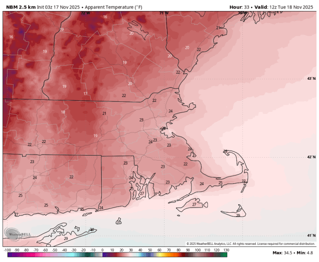
Wind chills will be in the 20s when you head out the door Tuesday morning. Image provided by WeatherBell.
The week starts off with low pressure continuing to slowly move away from the region and into Atlantic Canada. The result will be breezy and cool but dry conditions for Monday and Tuesday. A weak system passes south of the region later Wednesday, but high pressure will build in, so we’ll stay dry with lighter winds. Thursday should be another dry and cool day with high pressure in control. A low pressure system will bring some rain and slightly milder air in on Friday, with some gusty winds possible once again as the system pulls away Friday night. High pressure should build in for the weekend with drier and cooler conditions. We will be keeping an eye on a wave of low pressure riding along the cold front as it pushes offshore, but for now, it looks like it will pass too far south to have any impact here.
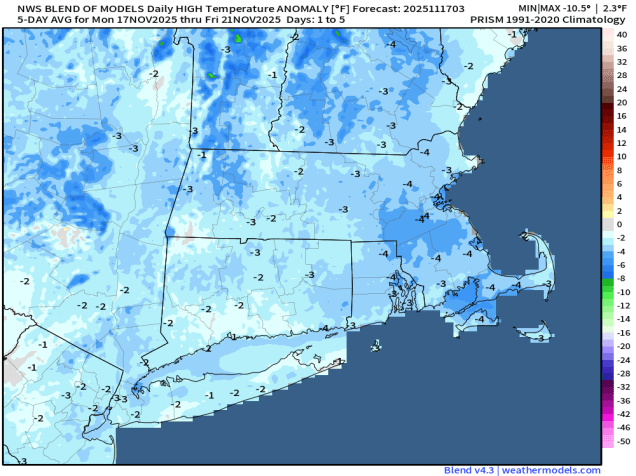
Temperatures will be below normal for much of the upcoming week. Image provided by Weathermodels.com
Monday: A mix of sun and clouds, windy. High 37-44.
Monday night: Clear skies, breezy. Low 28-35.
Tuesday: Sunshine and a few afternoon clouds, breezy. High 39-46.
Tuesday night: Clear to partly cloudy. Low 25-32.
Wednesday: Mostly sunny. High 40-47.
Wednesday night: Becoming partly to mostly cloudy. Low 25-32.
Thursday: More clouds than sun. High 42-49.
Thursday night: Mostly cloudy. Low 30-37.
Friday: Cloudy with showers likely. High 48-55.
Saturday: Intervals of clouds and sun. High 45-52.
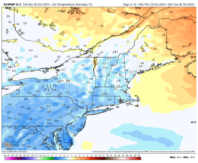
Much cooler air is on the way for a good chunk of the upcoming week.
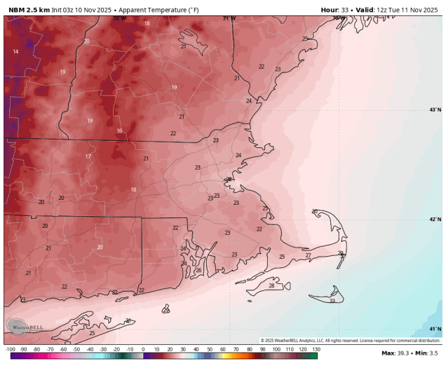
When you wake up Tuesday morning, wind chills will be in the 20s. Image provided by WeatherBell.
A strong cold front will move across the region today, while a developing wave of low pressure rides up along that front, bringing some more rain in, especially during the morning and early afternoon hours. It’ll be mild ahead of the front in the morning, but much cooler air will quickly move in behind the front during the afternoon and evening. How cool are we talking? High temperatures on Tuesday will only be in the upper 30s and lower 40s, but it will be breezy, so wind chills will only be in the 20s and 30s. Yes, we’re talking about wind chills. It’s that time of year. A large upper-level low pressure area will then make its way into the region. While this will bring much cooler air into our area, some records may be set in parts of the Southeast, as temperatures may drop to freezing or below all the way to the Gulf Coast. With the upper low nearby we’ll still have some clouds around with a few showers or flurries possible. Yes, snow flurries. Really. The upper low will drift into Atlantic Canada for the middle to latter portion of the week and into the weekend and high pressure will try to build in, but we’ll still have a few disturbances moving through at times, generating some additional clouds along with a few rain or snow showers, while keeping temperatures below normal for mid-November.
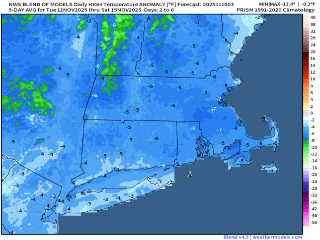
Temperatures will be 5-10 degrees below normal for much of the week. Image provided by Weathermodels.com
Monday: Occasional showers, some periods of steadier rain at times. High 54-61.
Monday night: Showers end in the evening, becoming partly cloudy to clear. Low 28-35.
Tuesday: Some morning sun, then clouds return, a few rain or snow showers are possible, breezy. High 36-43.
Tuesday night: Partly to mostly cloudy. Low 28-35.
Wednesday: More clouds than sun, breezy, chance for a few rain or snow showers. High 41-48.
Wednesday night: Partly cloudy. Low 32-39.
Thursday: Partly sunny, breezy, a few showers possible. High 44-51.
Thursday night: Clear to partly cloudy. Low 29-36.
Friday: A mix of sun and clouds, breezy. High 42-49.
The weather pattern will turn a bit more active this week.
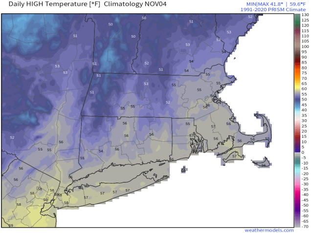
Average high temperatures in early November are in the mid-50s. Image provided by Weathermodels.com
We’re starting off dry today as high pressure slides offshore, but there are two systems heading our way. Low pressure heading up the East Coast will pass by the region later today, producing some light rain across parts of eastern Massachusetts and Rhode Island. At the same time, another system crossing southeastern Canada will send a cold front our way, with some additional rain showers across much of the region tonight. Behind the front, breezy and cooler conditions are likely as high pressure builds in for Tuesday. Another system quickly follows for late Wednesday and Wednesday night, with another round of rain showers, with gusty winds likely behind the system on Thursday. High pressure builds back in, and as it moves eastward, winds will shift into the southwest on Friday, allowing milder air to move back in. It will be short-lived though, as another cold front brings in some showers for Friday night. Saturday should be another dry and cooler day, but yet another system follows on Sunday with another round of showers expected.
Storms will move through the region every other day this week. Loop provided by Pivotal Weather.
Monday: Becoming mostly cloudy with showers developing in the afternoon, mainly across eastern Massachusetts and Rhode Island. High 53-60.
Monday night: Showers end in the evening, skies clear out after midnight, breezy. Low 39-46.
Tuesday: Plenty of sunshine, breezy. High 50-57.
Tuesday night: Clear to partly cloudy. Low 36-43.
Wednesday: Increasing clouds. High 53-60.
Wednesday night: Cloudy and becoming breezy with scattered showers. Low 38-45.
Thursday: Becoming partly to mostly sunny, breezy. High 47-54.
Thursday night: Partly cloudy. Low 28-35.
Friday: Partly sunny in the morning, then clouds thicken up, showers possible at night. High 51-58.
Saturday: Morning showers, then clouds give way to some afternoon sun. High 54-61.
Sunday: Partly to mostly cloudy with a chance for more showers. High 52-59.
Despite last week’s heavy rain, we’re still in a drought for much of the region and really need more rain. Well, we are going to get some today.
A cold front will produce showers and thunderstorms this morning as it moves through. Loop provided by Weathermodels.com
A strong cold front will cross the region this morning. Ahead of this front we can expect some heavy rain, maybe a rumble of thunder, and some gusty winds. While this could have some impacts on the morning commute, it will be short-lived, as the rain should end with the front moving offshore by early afternoon. Gusty west winds behind the front will send temperatures downward through the afternoon. We’ll clear out at night as high pressure builds in, giving us some sunshine on Tuesday, but clouds will quickly return Tuesday night ahead of another cold front. This one will produce more showers Wednesday morning, but it will also move through fairly quickly, with skies starting to clear out in the afternoon. High pressure then builds in with cooler weather for the end of the week, but with an upper-level low moving in, we’ll see some clouds each day, and possibly a few showers at times. The upper-level low lifts out over the weekend as high pressure moves overhead with dry and cool conditions.
Temperatures will be below normal for the end of the week and the weekend. Image provided by WeatherBell.
Monday: Rain likely during the morning, possibly heavy at times, ending from west to east by early afternoon, skies start to clear out late in the day, breezy, especially during the morning and early afternoon. High 60-67 in the morning, temperatures start falling in the afternoon.
Monday night: Becoming partly cloudy to clear with diminishing winds. Low 44-51.
Tuesday: Mostly sunny, some clouds start to move back in late in the day. High 58-65.
Tuesday night: Becoming mostly cloudy with showers developing before daybreak. Low 47-54, temperatures may rise a little overnight.
Wednesday: Showers likely during the morning, ending by early afternoon, followed by clearing late in the day, breezy. High 60-67.
Wednesday night: Clear to partly cloudy. Low 40-47.
Thursday: Sunshine and some afternoon clouds, a sprinkle is possible, breezy, cooler. High 54-61.
Thursday night: Clear to partly cloudy. Low 37-44.
Friday: A mix of sun and clouds, slight chance for a shower. High 52-59.
Some slow improvement is expected as the week goes on, but the start of the week will be rather nasty.
Low pressure will remain off the East Coast for much of the week. Loop provided by Tropical Tidbits.
Low pressure continues to meander around off the Mid-Atlantic coast today, with more rain, some of it heavy, strong winds, especially near the coast, and coastal flooding around the time of high tide, especially along east and northeast-facing coastlines. The low will start to drift eastward on Tuesday, with rain tapering off to showers and eventually ending, and winds slowly dying down, but it still won’t be a great day. By Wednesday the system will be south of Nova Scotia, but an upper-level low will move into the Northeast, keeping the clouds and cool temperatures around, with a few showers or some drizzle possible, especially near the coast, as north to northeast winds will remain gusty off the Atlantic. Thursday won’t be that much different than Wednesday as the upper low only slowly moves eastward.
Much of the region will pick up another 1-2″ (or more) of much needed rain before it ends. Images provided by Pivotal Weather.
We finally start to see some improvement by Friday as high pressure continues to build in at the surface, but also aloft. Saturday looks to be the pick of the week with sunshine and milder temperatures with high pressure in control. Sunday will be a warmer day, but we won’t see as much sunshine. Low pressure moving into the Great Lakes will send some clouds into the region. Whether we see any showers before the end of the day is still a question mark, but for now, it looks like most of the day should remain dry.
Temperatures could approach or exceed 70 on Sunday. Image provided by WeatherBell.
Monday: Windy with rain, heavy at times. High 51-58, a little milder across southeastern Massachusetts and Cape Cod.
Monday night: Breezy, rain tapers off to showers. Low 46-53, a little milder across southeastern Massachusetts and Cape Cod.
Tuesday: Cloudy and breezy with more showers, tapering off during the afternoon from west to east. High 55-62.
Tuesday night: Partly to mostly cloudy, showers ending in the evening in eastern areas, winds diminish. Low 45-52.
Wednesday: More clouds than sun, breezy, chance for a few showers or drizzle near the coast. High 58-65.
Wednesday night: Partly cloudy, breezy, a few showers are drizzle along the coast. Low 37-44.
Thursday: Intervals of clouds and sun, breezy, another shower or some drizzle possible near the coast. High 51-58.
Thursday night: Partly cloudy, breezy. Low 36-43.
Friday: Mostly sunny, breezy in the morning. High 55-62.
Saturday: Sunshine and some afternoon clouds. High 58-65.
Sunday: Partly sunny, showers possible late in the day. High 64-71.
It’s going to feel like summer for a few more days, but you’ll be trading the flip-flops for sweatshirts later this week.
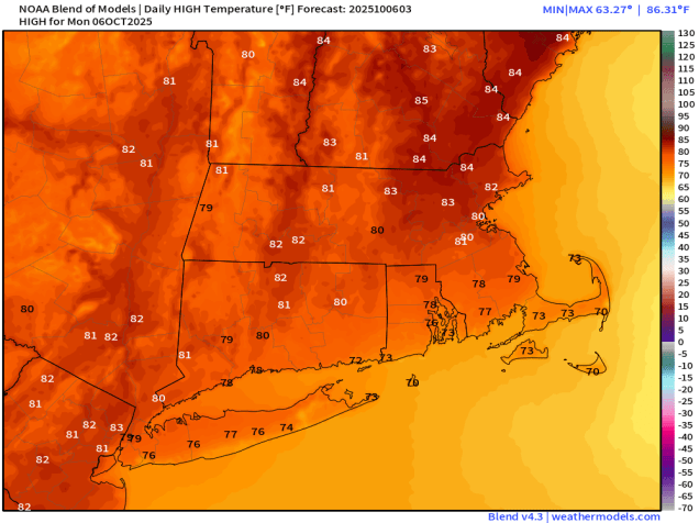
Temperatures should reach the lower to middle 80s this afternoon well away from the South Coast. Image provided by Weathermodels.com
High pressure remains on control to start the week with more sunshine and unseasonably warm temperatures. Many locations away from the South Coast will top 80 again today, with a seabreeze keeping the South Coast and Cape Cod in the 70s. Tuesday looks like another warm day with gusty southwest winds, but clouds will be on the increase ahead of an approaching cold front. That front will bring in some much-needed rain late Tuesday night into Wednesday, with temperatures getting back closer to normal for early October thanks to the cloudcover and rain. The front settles offshore later Wednesday and high pressure starts to build back in. Much cooler air moves in for Thursday, with many spots likely staying in the 50s all day.
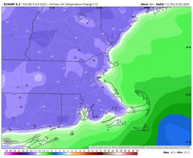
Temperatures Thursday morning will be 15-20 degrees cooler than Wednesday morning. Image provided by WeatherBell.
We’ll stay on the cooler side for Friday and Saturday, but temperatures will be a little closer to normal, as winds shift back into the southwest with the high sliding offshore. Sunday is a bit of a question mark at this point. A low pressure area will be developing off the Mid-Atlantic coastline. Some models try and bring it northward, bringing in some additional much-needed rain, while other models have it stay off to the south with the high to the north blocking it. We’re going to lean toward the latter scenario for now (“When in drought, leave it out”), but this is something we’ll be keeping an eye on as the week progresses.
Will Sunday be wet or dry? It’s too early to tell. Images provided by Pivotal Weather.
Monday: Patchy morning fog, otherwise plenty of sunshine with a few afternoon clouds. High 79-86, except 71-78 across the South Coast and Cape Cod.
Monday night: Clear to partly cloudy with a little patchy fog again. Low 53-60.
Tuesday: Mostly sunny in the morning, increasing and thickening clouds in the afternoon, breezy. High 74-81, a little cooler near the South Coast and Cape Cod.
Tuesday night: Mostly cloudy, showers developing after midnight. Low 57-64.
Wednesday: Rain likely during the morning, tapering off from northwest to southeast during the afternoon, some clearing late in the day, especially north and west of Boston, breezy. High 63-70 in the morning, temperatures start dropping in the afternoon.
Wednesday night: Becoming clear. Low 38-45, a little milder across Cape Cod.
Thursday: Lots of sunshine. High 54-61.
Thursday night: Clear skies. Low 33-40, a little milder in urban areas and across Cape Cod.
Friday: Mostly sunny. High 57-64.
Saturday: A mix of sun and clouds. High 60-67.
Sunday: More clouds than sun with a chance for showers, especially late in the day, becoming breezy. High 58-65.
There’s a four letter word that begins with the letter R and rhymes with main that we really need, but you won’t find it in our forecast for the next week.
None of the models are forecasting any rain around here for the next 7 days. Images provided by Pivotal Weather.
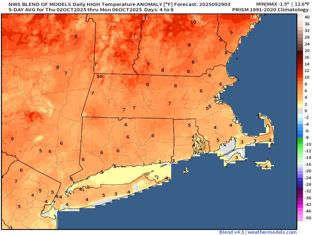
The week starts off with high pressure in control, keeping us rather mild for the end of the September. A cold front will move through on Tuesday, but only a few clouds will accompany it. Behind it, strong high pressure builds in with gusty north to northeast winds bringing much cooler air in for Wednesday and Thursday. Meanwhile, with Hurricane Humberto and Tropical Storm Imelda well offshore (more on them in a moment), the gradient between the large high and those systems will result in gusty winds towards the middle of the week. By the end of the week and the weekend, the high will slide off to the south, keeping us dry, but with temperatures getting back to near to above normal levels.
Temperatures will turn above normal once again for the end of the week and the weekend. Image provided by Weathermodels.com
Meanwhile, as previously mentioned, we have both Hurricane Humberto and Tropical Storm Imelda in the Atlantic at this time. While both storms could bring some adverse weather to Bermuda over the next few days, and they will both generate rough surf for the East Coast, they should both stay offshore, much to dismay of the Facebook Forecasters everywhere who were tossing around phrases like “Fujiwara Effect” without actually understanding what it meant.
Tropical Storm Imelda (lower left) and Hurricane Humberto (lower right) continue to churn up the Atlantic. Loop provided by NOAA.
As of 2am Monday, Hurricane Humberto was centered about 400 miles south-southwest of Bermuda, moving toward the northwest at 14 mph. After reaching Category 5 strength over the weekend, the storm was still a Category 4 system with maximum sustained winds near 140 mph. Humberto should turn northward passing west of Bermuda Monday night and Tuesday before turning northeastward. Humberto may produce some gusty winds and heavy rain across Bermuda, which is why a Tropical Storm Watch has been issued. By Wednesday, Humberto will transition into an extratropical storm as it heads east-northeastward into the open waters of the Atlantic.
Forecast track for Hurricane Humberto. Image provided by the National Hurricane Center.
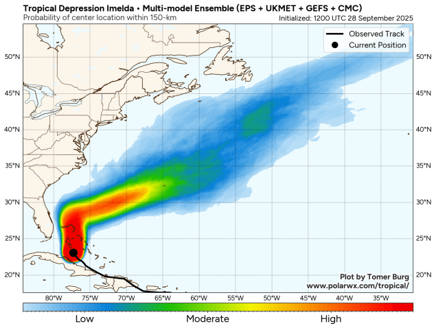
Closer to the East Coast is Tropical Storm Imelda, crossing the Bahamas early this morning while moving northward at 8 mph. Imelda has maximum sustained winds near 45 mph, and has been very slow to get organized. It will continue to bring squally conditions to the northwestern and central Bahamas on Monday where a Tropical Storm Warning remains in effect. As Imelda heads northward, some heavy rain may impact coastal portions of the Carolinas. By Tuesday, the storm should make a hard right turn and pull away from the coast, while strengthening, possibly becoming a hurricane by midweek. The current forecast calls for Imelda to pass very close to Bermuda Wednesday night or Thursday as a hurricane, making for a very rough week for the British Overseas Territory. After that, it should also become an extratropical storm over the open waters of the Central Atlantic.
Imelda could become a threat to Bermuda later this week. Image provided by Polar Wx.
Monday: Sunshine dimmed by some afternoon high clouds. High 73-80.
Monday night: Partly to mostly cloudy. Low 54-61.
Tuesday: Partly sunny. High 70-77.
Tuesday night: Clear to partly cloudy, becoming breezy. Low 44-51.
Wednesday: Mostly sunny, breezy, cooler. High 59-66.
Wednesday night: Clear skies, breezy along the coast. Low 38-45.
Thursday: Plenty of sunshine, breezy in the morning. High 57-64.
Thursday night: Clear to partly cloudy. Low 38-45.
We’re not going to get much, if any, relief for the drought this week across the majority of the region, but temperatures should remain comfortable.
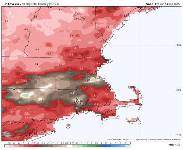
Over the past 90 days, rainfall totals across the region are roughly 2-5 inches below average normal. Image provided by WeatherBell.
We start the week off with high pressure in control, giving us a couple of dry and warm days for Monday and Tuesday, with a seabreeze keeping coastal areas a little cooler, especially today. Wednesday and Thursday are the days with the most uncertainty at this point. We’ll still have high pressure to the north, but a low pressure area will be passing offshore. This will send in some clouds, but similar to last week’s system the question is how far north the rain shield will get. Some models keep it all offshore, several bring it up to the South Coast, some bring in farther inland. Given then the models overestimated how far inland it would get with the system last week, we’re inclined to think that the rain probably won’t get much farther inland than the South Coast, with most of it falling Wednesday night into early Thursday. The system pulls away later Thursday, then a cold front drops down from the north on Friday. The models show most of the rain with the front drying up before it gets here, so the front should move through with little fanfare on Friday. Behind it, high pressure returns with much cooler air on Saturday, though temperatures should start to moderate a bit on Sunday.
Most of the models keep what little rain we’re expecting close to the South Coast late Wednesday into Thursday. Images provided by Pivotal Weather.
Monday: Areas of morning fog, otherwise partly to mostly sunny. High 71-78, a little cooler along the coast.
Monday night: Partly cloudy, areas of fog developing. Low 50-57.
Tuesday: A mix of sun and clouds. High 70-77, a little cooler along the coast.
Tuesday night: Partly to mostly cloudy. Low 50-57.
Wednesday: More clouds than sun, chance for a few showers, mainly near the South Coast. High 69-76.
Wednesday night: Partly to mostly cloudy, chance for a few showers near the South Coast. Low 54-61.
Thursday: Morning clouds, maybe a shower near the South Coast, becoming mostly sunny during the afternoon. High 75-82, a little cooler across Cape Cod.
Much of the upcoming week will be dominated by quiet and cool weather thanks to a large high pressure area.
Temperatures will be several degrees below normal for much of the week. Image provided by WeatherBell.
The cold front that produced severe weather on Saturday and a cool but beneficial rainfall on Sunday has pushed offshore and high pressure will build in bringing drier air in along with temperatures that are below normal for today and Tuesday. Things could get a little complicated for part of the region for Wednesday. An area of low pressure will pass well offshore, but the precipitation shield around the edge of the system could get close to parts of the South Coast, possibly even a little farther northward. However, the high to the north looks like it may remain strong enough to keep most of the rain offshore, so we’re going to lean towards a dry forecast for now. High pressure returns for the end of the week and start of the weekend. A cold front will move through with little fanfare on Sunday, keeping us dry.
An offshore system may produce some rain across Cape Cod and the South Coast, or maybe it won’t. Images provided by Pivotal Weather.
Monday: Partly sunny. High 66-73.
Monday night: Clear to partly cloudy. Low 47-54.
Tuesday: Sunshine and some afternoon clouds, breezy near the coast. High 66-73.
Tuesday night: Partly to mostly cloudy. Low 49-56.
Wednesday: Intervals of clouds and sun, chance for a few showers near the South Coast and Cape Cod. High 65-72.
Wednesday night: Any showers end in the evening, becoming partly cloudy to clear. Low 50-57.
Happy Labor Day and welcome to September. It marks the unofficial end of summer and the official start of meteorological autumn. College football is underway, the pros start this week, hockey training camps start up in a couple of weeks, pumpkin everything is available everywhere, and after a cool August, warmer weather will return for a few days this week.
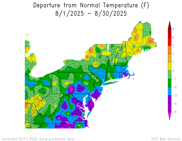
Temperatures were below normal across much of the Northeast during August. Image provided by the Northeast Regional Climate Center.
High pressure will keep us dry for the first half of the week, likely right into Thursday, but with an upper-level low nearby, we’ll still have some afternoon clouds each afternoon. Temperatures will be close to normal for early September to start the week, but as the high slides offshore, southwest winds will bring warmer and eventually more humid air in towards Wednesday and Thursday. A slow-moving cold front will move in Thursday night, with some showers and a few thunderstorms likely on Friday. With the front taking its time, Saturday may also be a warm and humid day, with the potential for some additional showers or thunderstorms, depending on when the front actually moves across the region. High pressure should build in behind the front for Sunday with cooler and drier weather, just in time for the Patriots home opener in Foxborough.
We’re not expecting a lot of rain with the cold front at the end of the week, but every little bit helps as the drought worsens. Images provided by Pivotal Weather.
Monday: Partly sunny. High 71-78, coolest along the coast.
Monday night: Partly cloudy with some patchy fog possible. Low 52-59.
Tuesday: Sunshine and some afternoon clouds. High 72-79, coolest along the coast.
Tuesday night: Clear to partly cloudy. Low 51-58.
Wednesday: A mix of sun and clouds. High 74-81, coolest along the coast.
Wednesday night: Clear to partly cloudy. Low 53-60.
Thursday: Partly to mostly sunny, breezy. High 75-82, coolest along the South Coast and Cape Cod.
Thursday night: Becoming cloudy, showers possible late at night. Low 57-64.
Friday: More clouds than sun with showers and a few thunderstorms likely, breezy, humid. High 73-80.
Saturday: Partly sunny, humid, a few additional showers or thunderstorm possible, breezy. High 75-82.
Sunday: Becoming partly to mostly sunny, drier. High 70-77.