Meteorological summer ended last Thursday. Pumpkin everything has arrived, college football has begun, the NFL starts the regular season this week, kids are back in school, Christmas stuff has even started showing up in stores. Summer is over, right? Astronomical summer doesn’t end until the autumnal equinox, which occurs at 2:49AM on September 23. Mother Nature will remind you this week that it’s still summer.
The forecast for the first half of the week is fairly simple. High pressure will remain in control with sunny days, warm to hot temperatures, coastal seabreezes, and increasing humidity. With the humidity, we’ll also have some patchy fog developing during the next few nights. Temperatures will get well into the 80s during the afternoons, with some spots topping 90, though coastal locations will likely drop into the 70s during the afternoons. The latter half of the week is where things get tricky.
Thursday looks quite toasty away from the coastline. Image provided by WeatherBell.
Thursday is likely to be another very warm to hot and humid day, but clouds will be moving in ahead of an approaching frontal system. Some showers and thunderstorms may move in late in the day, but it is just as likely that Thursday remains rain-free. Showers and thunderstorms look more likely on Friday, but temperatures will be highly dependent on the timing of the front. A frontal passage earlier in the day means cooler temperatures, but a later frontal passage could mean another day with temperatures topping 80. Some models don’t show the front moving through until Saturday, which could mean yet another warm day, but also more showers and thunderstorms. The front may stall out nearby, which means the unsettled weather could even linger into Sunday. With the Patriots set to open their season in Foxborough at 4:25pm next Sunday, fans are hoping for nice weather for the game itself and pregame tailgating.
The quest for a record 7th Lombardi trophy begins on Sunday.
Monday: Patchy morning fog, otherwise sunshine with a few afternoon clouds. High 82-89, cooler along the coast.
Monday night: Partly cloudy, areas of fog develop. Low 61-68.
Tuesday: Becoming mostly sunny. High 84-91, cooler along the coast.
Tuesday night: Clear to partly cloudy, patchy fog possible again. Low 65-72.
Wednesday: Mostly sunny. High 85-92, cooler along the coast.
Thursday: Morning sun, increasing afternoon clouds, showers and thunderstorms possible late in the day. High 87-94, cooler along the coast.
Friday: More clouds than sun with some showers and thunderstorms likely. High 81-88.
Saturday: Partly to mostly cloudy with a chance for more showers and thunderstorms. High 78-85.
Sunday: Intervals of clouds and sun, chance for another shower or two. High 75-82.
A tropical wave way out in the Atlantic has a high likelihood of becoming a tropical depression in the next few days. Image provided by the National Hurricane Center.
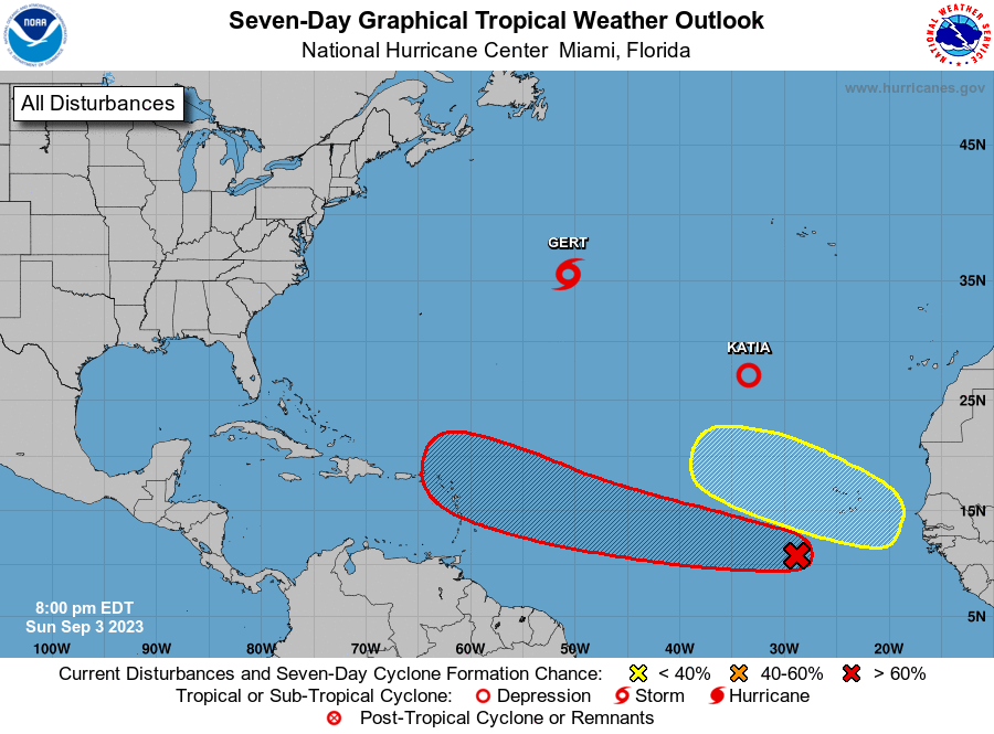
Finally, a word about the tropics. There is a tropical wave way out in the Atlantic that is slowly getting better organized. It could become a tropical depression in the next few days. It is at least 5 days away from potentially impacting the islands in the eastern Caribbean, if at all, and assuming it actually develops. There have been a few of the forecast models that have been showing that this storm could be a threat to the East Coast. At this point in time, that is pure hype and nothing else. These same models have done a horrible job forecasting actual tropical systems this season, let alone ones that haven’t even developed yet. Could this system impact the East Coast? Sure, anything is possible, but that’s a minimum of 8-10 days away from even potentially happening. This is not something you should be too concerned about at this point in time. If there is a time to be concerned, we’ll let you know well in advance. For now, ignore the hype.
The final days of meteorological summer feature more rain, which is pretty much keeping to the theme we had all summer.
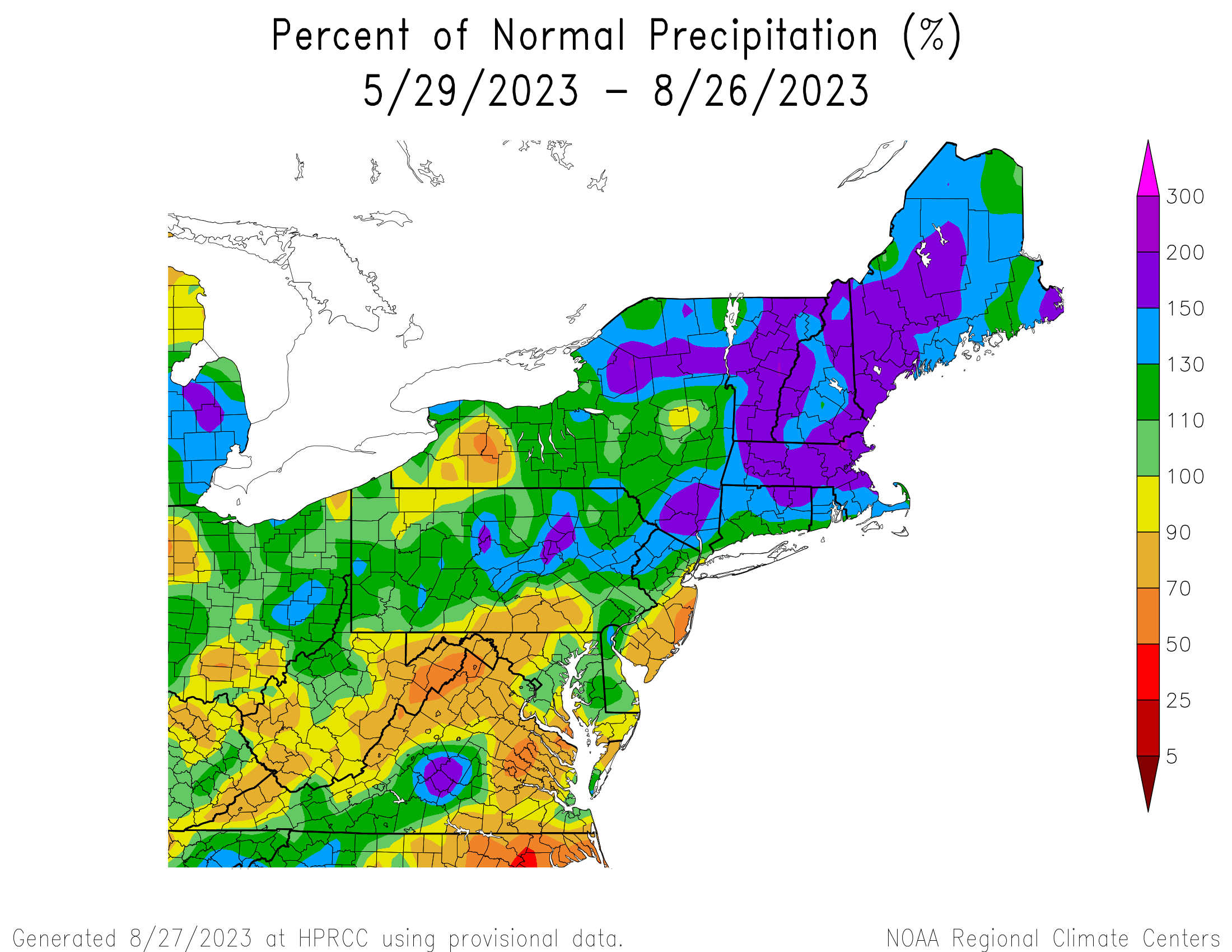
Rainfall has been well above normal across New England this summer. Image provided by the Northeast Regional Climate Center.
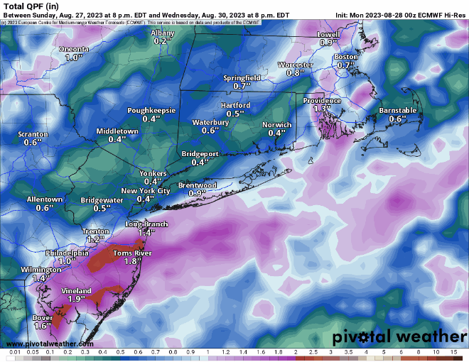
The week starts off with a rather complex forecast, but today should be mainly dry with high pressure moving offshore. With the high centered mainly north and then east of us, we’ll have onshore winds, keeping temperatures on the cooler side of normal near the coastline. Moisture will begin streaming northward in the form of high clouds today, though they will thicken up and lower later in the day. Here’s where things start to get complicated. A frontal system is currently stalled out across the Southeast, it will gradually lift northward tonight and Tuesday, allowing some tropical moisture to follow. As moisture rides northward along the front, some rain is expected to move in late tonight and Tuesday, especially across southeastern New England. Some of this rain could be quite heavy, but how far north and west the rain shield extends, and how far northward the heavy rain gets is still a question mark. Right now, it looks like it’ll be mainly across the South Coast and parts of southeastern Massachusetts, but that is obviously subject to change. At the same time, we’ll also have another cold front approaching from the northwest. We’ll also be keeping a close eye on Hurricane Franklin well offshore and Tropical Storm (possibly Hurricane) Idalia in the Gulf of Mexico (more on these two below). Franklin will be helping to push the front to our south northward, while the other front moves in from the west. In between, we’ll have another round of showers and thunderstorms on Wednesday, especially during the morning hours, before the approaching front finally moves through the region. Again, some heavy rain is possible in spots, but probably not with coverage or intensity expected across the South Coast on Tuesday.
More heavy rain is possible Tuesday and Wednesday. Images provided by Pivotal Weather.
High pressure builds in behind the cold front for Wednesday night, and remains in place into the weekend, keeping us mostly on the dry side, with temperatures starting cool, but gradually warming up as we get to the weekend. There is a potential fly in that ointment though. Idalia is expected to make landfall near the Big Bend area of Florida Tuesday night or early Wednesday, then head into the Carolinas and offshore on Thursday. The high building in here should block its northward progress and steer it out to sea well to our south. However, if the timing is off a bit, say Idalia slows down and makes landfall later than currently expected, then perhaps some of the moisture from it or its remnants ends up being dragged farther north, and ruins our forecast of drier weather into Labor Day Weekend. While this isn’t likely right now, it’s several days away, and things can change quickly, especially when tropical systems are involved. Either way, between Franklin and Idalia, we’ll have some rough surf across the beaches and coastal waters for much of the upcoming week, so keep that in mind if that’s where your plans bring you.
The GFS model shows high pressure building in for the end of the week and the weekend, shunting Idalia out to sea well to the south. Loop provided by Tropical Tidbits.
By the weekend and into Labor Day, another cold front will approach the region, but aside from a few showers as it moves in on Sunday, it looks to remain mostly dry and warm.
As for the tropics, here’s the latest on our two named systems:
Satellite loop showing Tropical Storm Idalia in the northwestern Caribbean and Hurricane Franklin northeast of the Bahamas. Loop provided by Tropical Tidbits
Hurricane Franklin was centered about 530 miles southwest of Bermuda as of 11pm Sunday, moving toward the north-northwest at 8 mph. Maximum sustained winds were near 105 mph. Franklin continues to get better organized and will continue to strengthen for another day or two as it heads northward and then northeastward over warm waters. While it will pass west and northwest of Bermuda late Tuesday and Wednesday, it will likely be close enough to produce tropical storm conditions on the island, with some locally heavy showers, and winds gusting upwards of 40-60 mph. A Tropical Storm Watch will likely be issued for Bermuda on Monday. After that, Franklin will likely head northeastward out into the open Atlantic while gradually losing tropical characteristics.
Forecast track for Hurricane Franklin. Image provided by the Bermuda Weather Service.
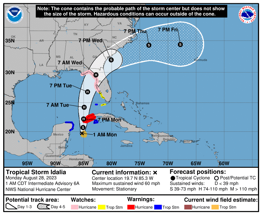
Meanwhile, Tropical Storm Idalia formed on Sunday in the northwestern Caribbean Sea. As of 2am Monday, it was centered about 150 miles south of the western tip of Cuba and barely moving. Maximum sustained winds were up to 60 mph. The forecast for Idalia calls for it to start heading northward, passing close to or across extreme western Cuba on Monday before heading into the eastern Gulf of Mexico. Steady strengthening is expected, and Idalia will likely become a hurricane on Monday. Once into the Gulf, the water is very warm, and the warm water extends rather deeply under the surface, which is one of the main ingredients that feeds tropical systems. While the upper-level environment may not be perfect, the potential is there for Idalia to rapidly strengthen on Monday and Tuesday, possibly into a major hurricane as it approaches the Gulf Coast of Florida. Eventually it will start turning more toward the northeast, but when that turn occurs will be crucial for pinpointing landfall. A Hurricane Watch is in effect for the Florida Gulf Coast from Englewood to Indian Pass, which includes the Tampa Bay area. Once inland, it will start to weaken, but it should start to turn more toward the east-northeast and eventually east, as the high building in up here should block its northward progress. How quick that turn occurs will determine how long it stays over land before moving into the Atlantic, which in turn will determine how strong it still is when it reaches the Atlantic, if it survives that long. We’ll have a much more detailed post about the tropics on Tuesday as Idalia nears the Gulf Coast and Franklin makes its closest pass to Bermuda.
Forecast track for Tropical Storm Idalia. Image provided by the National Hurricane Center.
Monday: Partly to mostly sunny in the morning after some patchy fog burns off, clouds increase and thicken in the afternoon. High 73-80.
Monday night: Mostly cloudy, showers developing near the South Coast, Cape, and Islands late at night. Low 58-65.
Tuesday: Mostly cloudy with showers likely, possibly a thunderstorm, except some locally heavy rain and thunderstorms possible across parts of Rhode Island, southeastern Massachusetts, Cape Cod, and Islands. High 71-78.
Tuesday night: Cloudy with scattered showers, possibly a rumble of thunder. Low 61-68.
Wednesday: Cloudy with more showers, possibly a thunderstorm, ending in the afternoon, followed by clearing in the evening. High 72-79.
Thursday: Sunshine and a few clouds, breezy. High 69-76.
Friday: Plenty of sunshine. High 72-79.
Saturday: Sunshine and some afternoon clouds. High 74-81.
Sunday: A mix of sun and clouds, breezy, chance for a shower. High 75-82.
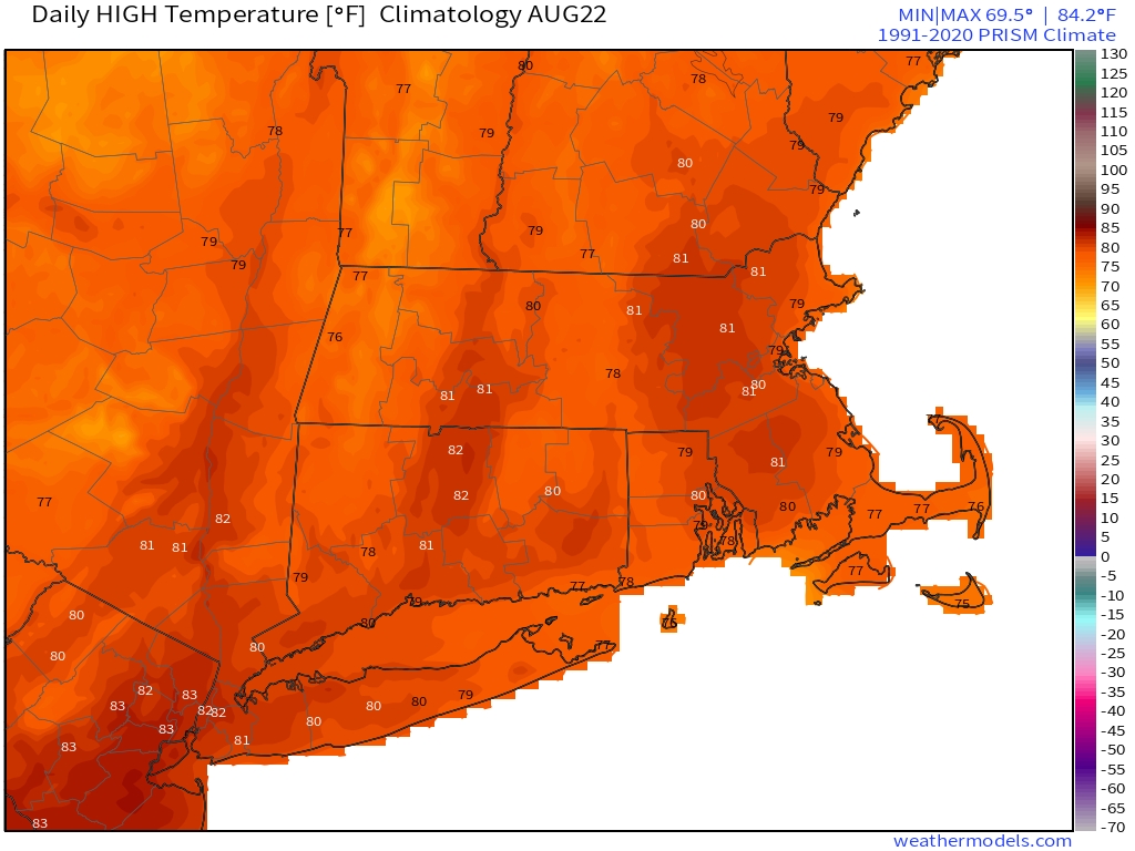
The week will start off warm and somewhat humid, but cooler air is on the way.
Normal high temperatures for late August are right around 80. Images provided by Weathermodels.com
A cold front will approach the region today, with warm and humid conditions likely ahead of it. We’ll also have plenty of clouds, though there will be some sunny breaks. The front won’t have much moisture with it, but there may be enough for a few showers along the front during the late afternoon and evening hours. Once the front moves through, high pressure builds in for Tuesday through Thursday with cooler temperatures (they’ll be below normal for late August), and lower humidity, so you can open all the windows and let some fresh air back in once again.
Dewpoints could drop into the upper 40s Tuesday night across the region. Image provided by WeatherBell.
Things turn unsettled for the end of the week. Low pressure moves into southeastern Canada, dragging a couple of frontal systems across the region. This will result in more clouds, higher humidity, and some episodes of showers, possibly some thunderstorms, between late Thursday night into Friday. A secondary system moves in for Saturday, but whether it crosses the region or stays offshore is still up for debate among the models, which has an impact not only on the weather we’ll expect, but the temperatures as well. Temperatures will remain on the cool side for late-August, thanks to the cloudcover and rainfall. By Sunday, high pressure builds back in with dry and cool weather returning.
The models have different ideas for what to expect on Saturday. Images provided by Pivotal Weather.
Monday: Intervals of clouds and sun, chance for a late-day shower. High 80-87.
Monday night: Mostly cloudy with a shower possible during the evening, skies start to clear late at night. Low 58-65.
Tuesday: Becoming mostly sunny and less humid. High 71-78.
Tuesday night: Clear skies. Low 53-60.
Wednesday: Sunshine and some afternoon clouds. High 71-78.
Thursday: Morning sun fades behind increasing clouds, showers possible at night. High 73-80.
Friday: Mostly cloudy with showers likely. High 70-77.
Saturday: Partly to mostly cloudy with a chance for showers. High 71-78.
An active weather pattern will continue across the region this week.
The first 12 days of August have been much cooler than normal, and this week won’t change that much. Image provided by the Northeast Regional Climate Center.
We start the week off with high pressure providing us with a dry and warm day today. Humidity levels will begin creeping back up as well. High clouds will filter the sunshine today, and then they will thicken up late in the day as the next storm system moves toward the region. A warm front will likely stall out near or just south of the region, with showers moving in ahead of it tonight. Occasional showers are likely on Tuesday, and with the front stalled out to the south, it will likely be a rather cool day. Showers end Tuesday night, then high pressure builds back in for Wednesday and part of Thursday with dry and seasonably warm conditions. The next system moves in later Thursday into Friday with some more showers and thunderstorms. High pressure returns for the week with dry and warm to potentially hot conditions.
Tuesday afternoon could be rather cool if the warm front doesn’t make enough progress northward. Images provided by Pivotal Weather.
Monday: Sunshine filtered through increasing and thickening clouds. High 78-85.
Monday night: Becoming mostly cloudy with showers developing. Low 63-70.
Tuesday: Plenty of clouds with showers and some thunderstorms likely. High 72-79, though areas North of the Mass Pike could stay in the 60s all day.
Tuesday night: Mostly cloudy, showers and thunderstorms ending. Low 61-68.
Wednesday: Partly sunny. High 75-82.
Thursday: A mix of sun and clouds, a few showers possible late in the day. High 76-83.
Friday: Partly sunny with some showers and thunderstorms around. High 77-84.
Saturday: Mostly sunny. High 76-83.
Sunday: Sunshine and some afternoon clouds. High 80-87.
“Everything in moderation, including moderation” – Oscar Wilde
Mother Nature is taking that quote to heart this week, as we’ll have moderately high temperatures at times, moderate humidity at times, and some moderate rain at times.
Dewpoints will jump into the 70s across the region on Tuesday. Images provided by WeatherBell.
A low pressure system will move across the Ohio Valley, passing north and west of the region over the next day or two. Some showers will develop ahead of the system today as it sends a warm front in, with a very noticeable spike in the humidity. The showers will be mostly on the light side, and not everyone will get them. We’ll have a bit of a lull in the activity during the afternoon, then an area of steadier rain will likely move in by evening, and continue overnight into Tuesday morning. We could be looking at a second round of showers and thunderstorms later in the day as the cold front trailing the low pressure system finally moves through and pushes offshore. Wednesday looks like the pick of the week, with high pressure building in, providing sunshine, warm temperatures and lower humidity. The latter half of the week and the weekend look unsettled at this time, with a series of disturbances moving through. These will generate showers and thunderstorms at times, but the timing of these disturbances is still in question. None of the days will be a washout, but if you’ve got outdoor plans, keep an eye on updated forecasts as the week goes on.
A few models show the potential for some heavy downpours tonight across the region, but most of the models do not. Images provided by Pivotal Weather.
Monday: Plenty of clouds with a few breaks of sunshine, some showers around, especially during the morning and early afternoon. High 72-79.
Monday night: Mostly cloudy and breezy with some showers and thunderstorms likely. Low 63-70.
Tuesday: Cloudy with showers and thunderstorms during the morning, some clearing in the afternoon, then another round of showers and thunderstorms possible late in the day. High 76-83.
After one of the wettest Julys on record, we’ve got an extended stretch of dry weather to start August.
It has been an extraordinarily wet July across the Northeast. Images provided by WeatherBell.
A weak cold front will cross the region today, generating some clouds and possibly a few showers this afternoon, otherwise, high pressure will be in control through Thursday, with sunshine, cool temperatures and, lower humidity levels. Yes, you can turn off the air conditioning and open the windows for the next several days and save on that electric bill. By the end of the week, another upper-level low will drop into the Great Lakes, while at the surface, a low pressure area moves into southeastern Canada, dragging a cold front across the region. The result will be some showers and thunderstorms on Friday and early Saturday, with some heavy rain possible. High pressure builds back in for later Saturday and Sunday with drier weather.
Some of the models show the potential for some heavy rain around here Friday into Saturday. Images provide by Pivotal Weather.
Monday: Morning sun with some afternoon clouds and a few showers or thunderstorms. High 75-82.
Monday night: Clear skies. Low 55-62.
Tuesday: Sunshine with some afternoon clouds again. High 73-80.
Tuesday night: Clear skies. Low 52-59.
Wednesday: Plenty of sunshine. High 72-79.
Thursday: A mix of sun and clouds, breezy. High 75-82.
Friday: Partly to mostly cloudy and breezy with showers and thunderstorms developing. High 74-81.
Saturday: Showers end early, becoming partly sunny. High 75-82.
Sunday: A mix of sun and clouds. High 77-84.
After a bit of a lull, we may have some activity in the Atlantic over the next couple of days. Images provided by the National Hurricane Center.
Finally, a quick note on the tropics. The potential exists for two named tropical systems to develop in the Atlantic over the next 24-48 hours, but neither of them will be a threat to any land areas. A tropical wave and associated area of low pressure has been slowly organizing as it made its way across the Atlantic over the past week. Conditions are favorite for some additional development as the storm turns toward the north well east of the Lesser Antilles today. It should head northward and then eventually northeastward, likely become a tropical depression and quite possibly a tropical storm over the next couple of days. It could eventually become a potent extratropical system as it heads toward the British Isles at the end of the week. There’s also a system off the North Carolina coast. This system produced heavy rain across parts of Florida and the Southeast over the past few days, and now that it is offshore again and over the warm waters of the Gulf Stream, it has a small window where it could become a tropical depression or tropical storm today before it merges with a frontal system and races northeastward over the open waters of the Atlantic. If either system does develop, we’ll have another post on Monday talking about the tropics around the world, as the Atlantic isn’t the only place with tropical activity at the moment.
It’s been a very wet July across most of the region, but this week will be drier, but also warmer.
Temperatures have been 2-4 degrees above normal across the Northeast this month and even warmer weather is expected this week. Image provided by the Northeast Regional Climate Center.
We start the week off with high pressure keeping the region dry and warm, but a weak upper-level trough of low pressure remains in place across the southeastern Canada. As little disturbances rotate around that trough, we may see a few showers and thunderstorms pop up each afternoon, but they’ll be widely scattered, and mainly across the interior. For most of us, it’ll just be partly to mostly sunny, quite warm, and not that humid for Monday and Tuesday. During the latter half of the week, both temperatures and humidity levels will be on the rise, with a couple of hot days expected for Thursday and Friday. Beyond that, a cold front will be dropping down from Canada, producing some showers and thunderstorms late Friday into early Saturday. The question is, when does the front actually move through? That’ll be the difference between another hot and humid day on Saturday or a cooler and drier day. By Sunday, the cooler and drier air should finally settle into most of the region.
Saturday could be either warm or hot, depending on which model you trust. Images provided by Pivotal Weather.
Monday: Sunshine filtered through some high clouds, slight chance for an afternoon shower or thunderstorm, mainly well north and west of Boston. High 82-89.
Monday night: Clear to partly cloudy. Low 64-71.
Tuesday: A mix of sun and clouds, a few showers and thunderstorms develop in the afternoon. High 81-88.
Tuesday night: Partly cloudy. Low 63-70.
Wednesday: Mostly sunny, just a very slight chance for an afternoon shower or thunderstorm. High 84-91.
Thursday: A mix of sun and clouds, a few showers and thunderstorms possible during the afternoon and evening. High 87-94.
Friday: Partly sunny, some showers and thunderstorms possible at night. High 88-95.
Saturday: Intervals of clouds and sun, chance for a few showers and thunderstorms, mainly early. High 82-82.
Yup, we’re still stuck in the same pattern we’ve been in for a while now, with an upper-level low sitting near the Great Lakes. Some days will be like yesterday – wet (or very wet), and some will be like today (dry), but there’s no persistent heat on the way.
Upper Air analysis shows our persistent upper-level low centered over Lake Superior, while a rather robust ridge over Arizona is helping to bake the Southwest. Image provided by NOAA.
After an extraordinarily wet day on Sunday, we’ll dry out today as high pressure builds in. It’ll still be warm and humid, but we’re not expecting any rain. Another frontal system will move toward the region on Tuesday, with another round of showers and thunderstorms expected during the afternoon and evening. A few of these storms may produce downpours, but for now, we’re not expecting a repeat on Sunday. High pressure returns with drier weather on Wednesday, then another system brings in more showers and thunderstorms later Thursday into Friday. Again, some downpours are possible, but a widespread heavy rain event doesn’t appear likely at this time Once that system moves out, drier air should move in for the weekend. This would be a welcome change from the past several weekends, which all seemed to feature some rain, but don’t consider it a lock just yet. It’s a week away and things can change.
The rain this week shouldn’t be as heavy as Sunday was, but there is still the potential for some locally heavy downpours. Images provided by Pivotal Weather.
Monday: Becoming mostly sunny. High 83-90.
Monday night: Partly cloudy. Low 66-73.
Tuesday: Intervals of clouds and sun, showers and thunderstorms develop in the afternoon. High 82-89.
Tuesday night: Partly to mostly cloudy, showers and storms end before midnight. Low 65-72.
Wednesday: A mix of sun and clouds. High 80-87.
Thursday: Partly sunny, showers and thunderstorms move in late in the day, continuing at night. High 77-84.
Friday: Showers end in the morning, some clearing in the afternoon. High 77-84.
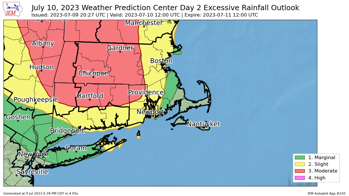
Stop us if you’ve heard this before – we’ll be dealing with upper-level lows and upper-level troughs of low pressure again this week, with more rain on the way.
There is a moderate risk for excessive rainfall across much of the interior today. Image provided by Iowa State University’s Iowa Environmental Mesonet.
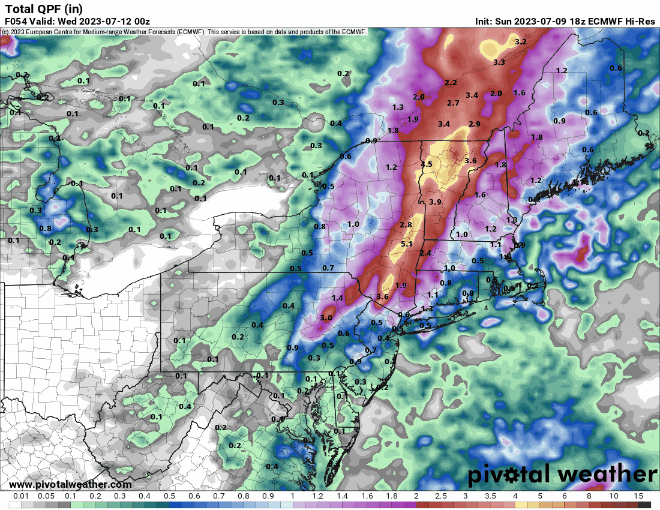
A frontal system will move into the region today while a wave of low pressure rides up along it. This system produced extraordinarily heavy rain across western New England and eastern New York yesterday. While we’ll have some of that heavy and thunderstorms moving in today, it shouldn’t be anywhere near the magnitude of what they experienced across the Hudson and Connecticut Valleys yesterday, where as much as 5-10 inches of rain caused widespread severe flooding. Some of the thunderstorms that move through may also produce gusty winds, but heavy rain remains the most significant threat.
The heaviest rain will fall across western and northern New England today and tonight, but some models still show some heavy rain totals around here. Images provided by Pivotal Weather.
That system will pull away on Tuesday with showers ending and some clearing, then high pressure builds in both at the surface and aloft for Wednesday. That means we’ll have sunshine and warm to hot and humid conditions – it’ll feel like summer once again. However, this dry interlude will be short-lived. Another trough of low pressure will start to move into the Midwest by Thursday, and only make very slow eastward progress through the weekend. As disturbances rotate through this upper trough, they’ll generate some showers and thunderstorms around here each afternoon from Thursday into Sunday. None of the days should be a washout, so don’t go cancelling any outdoor plans, but for now Friday and Sunday look to have the greatest coverage of showers and thunderstorms in the afternoon.
One upper-level low moves across the Northeast to start the week, another drops into the Great Lakes later in the week. Loop provided by Tropical Tidbits.
Monday: Plenty of clouds with showers and thunderstorms likely, some heavy rain possible, especially across the interior. High 70-77.
Our unsettled pattern will continue for a good chunk of the week, but some changes are expected.
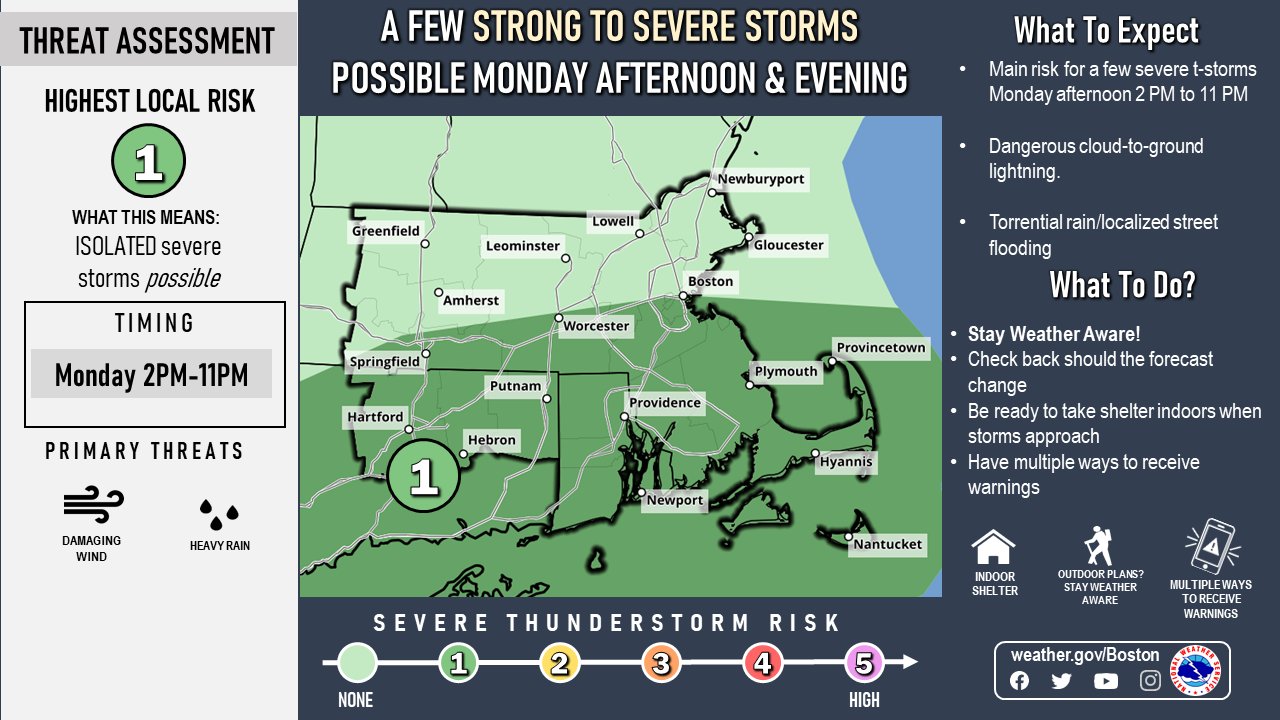
There is a risk for severe weather across the region today. Image provided by the National Weather Service office in Norton, MA.
We start the week off with a similar pattern to what we’ve had for a while now. An upper-level trough of low pressure moving from the Great Lakes into the Northeast with a frontal system at the surface stalled out across the region. That front will trigger some showers and thunderstorms again today, a few of which could be quite strong. More heavy rain is possible with some storms, which could lead to areas of flooding, especially from northern Connecticut across central and northeastern Massachusetts and southern New Hampshire, where as much as 2-4 inches of rain fell on Sunday. The front will dissipate across the region on Tuesday, with some additional showers and thunderstorms possible, but they shouldn’t be as widespread as today, which is good news for July 4th celebrations in many locations.
Some additional heavy rainfall is expected across parts of the region today and tomorrow. Images provided by Pivotal Weather.
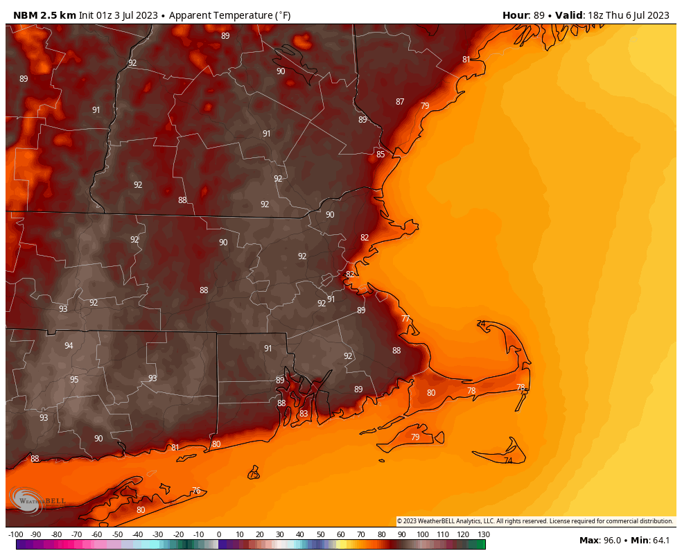
Wednesday and Thursday feature a change, as a ridge of high pressure builds in both at the surface and aloft. This means we’ll be drier and warmer, with many spots approaching 90 degrees. The change will be short-lived though, as another frontal system approaches on Friday, and slows down as it moves across the region next weekend. A wave of low pressure may ride along it while another upper-level trough moves in from the Midwest, meaning that we’re back in the humid and unsettled pattern. While some showers and thunderstorms are expected each day, none of the days should be a washout.
The combination of heat and humidity will make it feel like it’s in the lower 90s Thursday afternoon. Image provided by WeatherBell.
Monday: Morning fog, then intervals of clouds and sunshine with showers and thunderstorms developing, some may be locally heavy. High 77-84, possibly a little warmer across southeastern Massachusetts and Rhode Island.
Monday night: Partly to mostly cloudy, more showers and thunderstorms through the evening, tapering off overnight, areas of fog develop. Low 63-70.
Independence Day: Partly sunny with a chance for some additional showers and thunderstorms. High 76-83.
Tuesday night: Showers and storms end in the evening, then becoming partly cloudy. Low 62-69.
Wednesday: Partly to mostly sunny. High 81-88.
Thursday: Sunshine and a few clouds. High 83-90, a little cooler right at the coast.
Friday: A mix of sun and clouds, chance for a few late-day showers and thunderstorms. High 82-89.
Saturday: Partly sunny with some showers and thunderstorms possible. High 79-86.
Sunday: Intervals of clouds and sun with more showers and thunderstorms likely. High 77-84.