After today’s warm weather, it is definitely time for change, with cooler weather working its way into the region over the next few days.
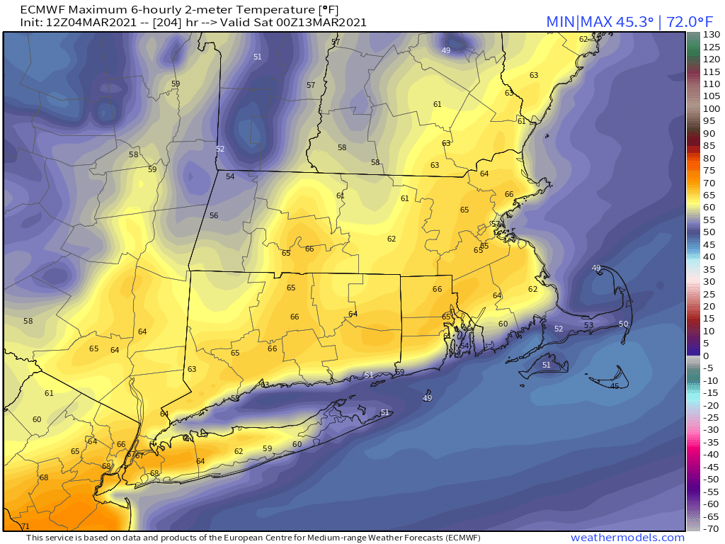
Temperatures have reached or exceeded 70 across much of the region this afternoon. Image provided by NOAA.
A cold front moves crosses the area late tonight with some clouds and possibly a shower or two, but the more noticeable impact will be cooler temperatures on Friday. Late Friday, a stronger cold front will move through. Like the first one, there will be little moisture with this front, but gusty northwest winds may create some issues at night, but not nearly as bad as the front from a week and a half ago. They will also bring much cooler weather in for Saturday. Winds will diminish during the day on Saturday with sunshine and temperatures closer to where they should be in mid-March. Sunday should be fairly similar with sunshine and seasonably cool temperatures, but winds may pick up a little. Monday also looks dry but breezy and even colder, with most places staying in the 30s all day.
Average high temperatures for the middle of March are in the middle 40s. Image provided by Weathermodels.com
Thursday night: Partly to mostly cloudy, chance for a few showers. Low 45-52.
Friday: A few showers near the South Coast and Cape Cod early, otherwise becoming mostly sunny and breezy. High 55-62.
Friday night: Clear to partly cloudy, windy. Low 23-30.
Saturday: Mostly sunny, breezy during the morning. High 38-45.
Saturday night: Clear to partly cloudy. Low 25-32.
Sunday: Partly to mostly sunny and breezy. High 40-47.
Sunday night: Clear to partly cloudy, breezy. Low 12-19.
Sunshine and cold temperatures. That’s pretty much what we have in store for the next several days.
A strong low pressure area over Labrador will be the dominant feature in our weather through tomorrow. Image provided by Environment Canada.
A strong area of low pressure will sit and spin across eastern Canada for the next few days. This will result in windy and chilly conditions across the region, with some clouds at times as well. Meanwhile, high pressure currently over western Ontario will slowly slide southeastward over the next few days, providing us with dry but chilly conditions through the weekend. As the high slides offshore early next week, the dry weather will continue, but a warming trend is expected.
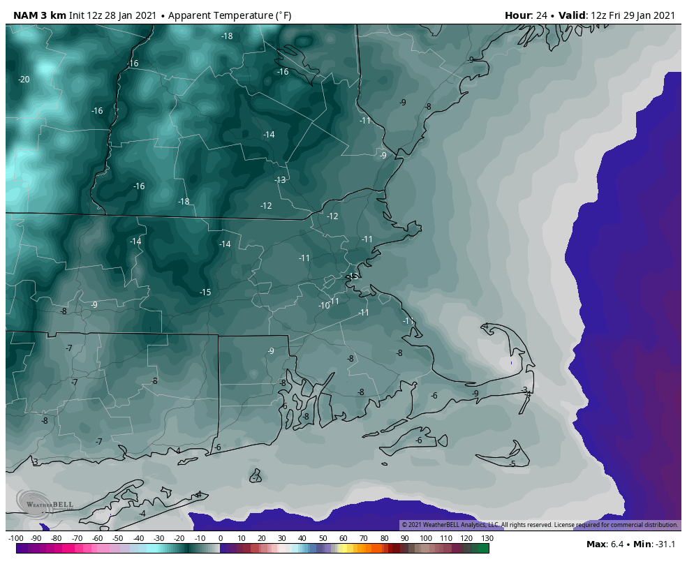
Temperatures will average nearly 10 degrees below normal over the next several days. Image provided by WeatherBell.
Thursday night: Partly cloudy and breezy. Low 12-19.
Friday: Partly sunny and breezy. High 27-34.
Friday night: Clear to partly cloudy. Low 11-18.
Saturday: Partly to mostly sunny, breezy again. High 27-34.
Saturday night: Clear skies. Low 10-17.
Sunday: Plenty of sunshine. High 29-36.
Sunday night: Clear to partly cloudy. Low 14-21.
Monday: Sunny, not as cold. High 36-43.
Temperatures could turn much milder during the second half of next week. Image provided by Weathermodels.com
The weekend starts off with some snow, and it looks like it might end with some snow as well, for at least part of the region.
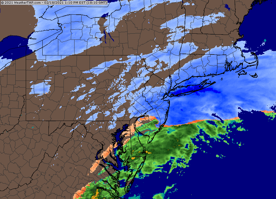
The steadiest snow has been confined to the South Coast thus far. Loop provided by Weathertap.
We’ve got a series of weak low pressure areas passing south of the region tonight into Friday night. This will produce some occasional light snow well into Friday night, possibly lingering into Saturday morning for east-coastal areas, thanks to northeast winds behind the last of the storm systems. Along the South Coast, some sleet or rain may mix in for a while tonight and early Friday, keeping accumulations down a bit. For most of the region, this will be a general 3-6 inch snowfall, a little less along the South Coast, perhaps a little more across eastern and southeastern Massachusetts. Considering the snow is falling over the span of 24-36 hours, it will be an annoyance, but not that big of a deal.
The NWS Blend of models is still closest to our thinking for snowfall. Image provided by Weathermodels.com
While we may see some sunshine develop on Saturday behind the storm, an upper-level low pressure area will cross the Northeast, generating more clouds and perhaps a few snow showers. These shouldn’t produce much additional accumulation. We’ll clear out for Saturday night and Sunday as high pressure builds in. Temperatures will be on the chilly side, but nothing that extraordinary for the latter half of February.
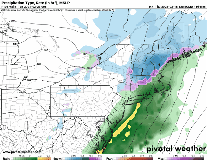
By Monday, the next storm system moves toward the region. With cold air in place, we’ll have snow developing across much of the region, but a change to rain seems likely, at least south and east of Interstate 95, possibly even farther inland. How far inland will depend on whether a secondary storm system develops to our south or not, which the models don’t agree on at this point. Either way, this system will be a fast-mover, and won’t contain a lot of precipitation, so even in places where it doesn’t change to rain, we’re not expected a lot of snow, possibly a few inches.
The models don’t agree on how far inland the rain/snow line will get on Monday. Images provided by Pivotal Weather.
Thursday night: Occasional light snow, possibly mixed with a little sleet or rain across the South Coast and Cape Cod. Low 21-28.
Friday: Occasional light snow, mixed with a little sleet or rain across Cape Cod and the South Coast. High 28-35.
Saturday: Plenty of clouds with a few sunny breaks, especially inland. A few snow showers are possible, especially in the morning in eastern areas. High 29-36.
Saturday night: Clearing. Low 12-19.
Sunday: Sunshine and a few clouds. High 28-35.
Sunday night: Becoming partly to mostly cloudy. Low 10-17.
Monday: Cloudy with light snow developing, changing to rain during the afternoon from Boston southward. High 35-42.
Who’s ready for some warmer weather? Well, you’d better head to Florida then, because it’s going to remain fairly chilly around here for a while.
High pressure builds in tonight with some clearing and a chilly night expected. Temperatures will drop into the single numbers in many areas, with some subzero readings possible. Friday will remain chilly with high pressure in control, but we’ll see more clouds as an upper-level disturbance crosses the region. Clouds will become more prevalent on Saturday as a storm system starts to approach from the southwest. This will bring in some light snow for Saturday night into early Sunday. Temperatures won’t be as cold as tonight and Friday, so we’ll probably see some sleet and/or rain mixing in, mainly south of Boston. This will not be a blockbuster storm, with most places likely seeing just 1-2 inches of snow, possibly a little more in a few spots. High pressure returns on Monday with dry and cold conditions.
We’re not expecting much snow from the system on Sunday. Image provided by Weathermodels.com
Thursday night: Clear to partly cloudy. Low 2-9, a little warmer along the coast.
Friday: A mix of sun and clouds. High 21-28.
Friday night: Mostly cloudy. Low 5-12.
Saturday: Mostly cloudy. High 23-30.
Saturday night: Cloudy with some light snow developing. Low 13-20.
Sunday: Plenty of clouds with some light snow, possibly mixed with sleet or rain south of Boston, ending by early afternoon. High 28-35.
Sunday night: Mostly cloudy. Low 16-23.
Monday: Clouds and a few sunny breaks. High 27-34.
While the next few days will be anything but quiet around here, we’re not expecting anything extraordinary in the weather department either.
Low pressure will move up the St. Lawrence Valley on Friday. As is usually the case when that happens, we’ll have somewhat milder air move in along with some light rain. However, temperatures will still be cool enough that the rain may start as snow north and west of Boston if it moves in by midday. As the milder air takes over, the snow should change over to rain, but there may be enough snow to coat the ground in spots. We’re not expecting a lot of rain, nor are we expecting a big warmup, so don’t expect much of the snow from the storm earlier this week to melt.
High pressure builds in behind the system for Saturday with some sunshine returning along with seasonable temperatures. The latter half of the weekend is where things get tricky. We’re watching two pieces of energy, one in the northern jet stream and another to the south. If these two were to meet up, or “phase”, we could end up with a big storm. Some of the models were hinting at that possibility earlier in the week, but it looks a lot less likely now. What is more likely to happen is that the southern system starts to develop but passes well south of the region, possibly delivering a little light snow to parts of the South Coast and maybe a little farther northward. The northern system will swing through here with some flurries or snow showers. Overall, not a big deal for most of us. Parts of the South Coast could see a few inches of snow depending on how far north the ocean storm actually gets, but otherwise, we’re not anticipating much accumulation across the region, unless things change in the next day or two.
The models do not agree on the placement of a storm system south of the region Sunday. Images provided by Pivotal Weather.
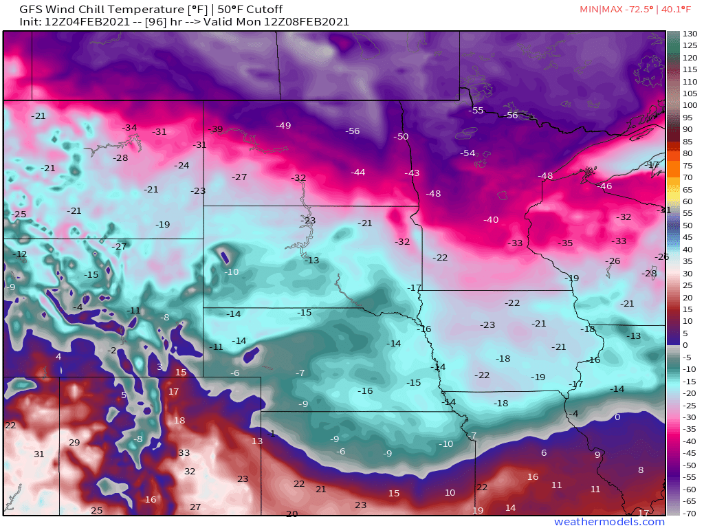
As we head into Monday, high pressure start to build back in with drier and colder weather. While it is likely the start of a colder pattern overall around here, temperatures will only be a little below normal for early February. The bulk of the cold air will stay well to our west. In parts of the Northern Plains and the Canadian Prairies, temperatures will be as much as 35-45 degrees below normal this weekend, with some areas dropping to 30-40 below zero at night, and daytime highs only in the -10 to -15 range. Wind chills will be colder than -50 in parts of the region.
By Monday morning, wind chills in parts of Minnesota and North Dakota will be colder than -50! Image provided by Weathermodels.com
Thursday night: Mostly cloudy. Low 17-24.
Friday: Cloudy with showers likely, mainly in the afternoon, starting as some wet snow north and west of Boston. High 37-44.
Friday night: Clearing. Low 21-28.
Saturday: Sunshine and a few clouds, breezy. High 32-39.
Bond villian Elliot Carver said it in “Tomorrow Never Dies”, but it’s appropriate for the forecast for the next several days – “Let the mayhem begin”
We start off with a developing low pressure system well offshore tonight. The system will continue to strengthen, but also continue to pull away, so it won’t directly impact us. However, it will produce northerly winds around here that will serve two purposes. First, they’ll continue to produce some ocean-effect snow across parts of eastern Massachusetts and the New Hampshire Seacoast, and second, they’ll usher in some of the coldest air thus far this winter.
Low pressure well south of New England shows up nicely on satellite imagery this afternoon. Loop provided by NOAA.
First, we’ll look at the ocean-effect snow. It’s been ongoing since early this morning, and will continue off and on into this evening. While it won’t amount to much for a good chunk of the region, right along the coast, especially Cape Ann, coastal Plymouth County, and Cape Cod, could see an inch or two in spots. On Friday, a disturbance rotating around the ocean storm will bring some more ocean-effect snowfall back into Cape Cod. This could result in additional accumulations, especially across the Outer Cape, where a few inches is possible.
A few inches of snow may accumulate across the Outer Cape over the next day or two. Image provided by Weathermodels.com
Back to the cold air. This past week has been rather chilly compared to the rest of January, but temperatures have only been near to a little below normal. That’s going to change tonight and this weekend. Skies will start to clear out tonight (except for Cape Cod), and it’s going to get cold. Temperatures will likely drop into the single numbers for much of the region tonight, but it will remain quite breezy, so we’re looking at wind chills of 10 to 20 below zero Friday morning. Wind Chill Advisories have been posted from Worcester County westward, but even without the advisory, you should know enough to dress warmly if you have to go outside.
Bundle up before you head outside Friday morning because it’s going to be chilly. Image provided by WeatherBell.
Friday looks rather chilly as well. Some clouds may move in from the ocean, but even in places where the sun is out, it’ll still be breezy and cold, with daytime highs only in the teens to lower 20s. Skies clear out again Friday night and winds will start to diminish, so we’re looking at another cold night, with some places possibly dropping below zero. Saturday should feature a lot of sunshine, but it will still be cold, with highs only in the upper teens to lower 20s. After another bitterly cold night Saturday night, temperatures should start to moderate a bit on Sunday, but we’ll also see clouds starting to move back in ahead of another storm system heading this way. This brings us to Monday.
For several days now, most of the forecast models have been showing the potential for a storm system to impact the Northeast early next week. They’ve bounced around with the details on strength, timing, and track, but in general, there’s been a fairly strong signal that something is going to happen around here after we flip the calendar to February. Well, that signal hasn’t gone away, and the Universal Hub website has upgraded to a Level 2 on the French Toast Alert System. In other words, don’t worry just yet. However, knowing how the media can be around here, and knowing what the models are showing, we’re issuing our own Extreme Hype Watch. An Extreme Hype Watch is issued when conditions are favorable for media hype of an event to reach extreme levels within the next 48-72 hours. If conditions warrant, a Hype Advisory or Extreme Hype Warning will be issued as the event draws nearer.
As for the system itself, there are still plenty of questions that need to be answered. We’ll have a large high pressure area in eastern Canada keeping some cold air in place. It’s not quite in the ideal position for a big storm here, but it is there. We’ll have a low pressure system moving through the Midwest that will redevelop over the Mid-Atlantic states, then head northeastward, likely passing south and east of New England, close to the “benchmark”. The benchmark is at 40 degrees North latitude and 70 degrees West longitude, about 90 miles south of Nantucket. Storms that pass over that spot are usually (but not always) in a prime position to deliver heavy snow to much of the region. Storms that pass north and west of there usually end up with a rain/snow line farther inland, and storms that pass south and east of there don’t always deliver snow far inland. This is more of a general rule than an absolute, but it’s something we look for. The other issue we have is that an upper-level low pressure area will be moving in, and the storm may get stuck underneath it, which could stall it out or have it meander around south of us for a day or so, which would result in an extended period of precipitation.
In addition to the models, another tool we use is analogs. You will most often hear about these in relation to a seasonal pattern or a hurricane season, but we can also use them for individual storms. Basically, we compare the pattern to previous setups, and see how it compares, and see what those previous setups produced to give us an idea of what is possible. Now, these analogs are run compared to the forecast of one model, so if that model isn’t the one your using, then the analogs might not be of much help. Based on the midday run of that model, the best analog for the pattern early next week is the storm of January 26-28, 2015. You may recall that storm received an extreme amount of media hype, and did produce very heavy snow around here, but was considered a “bust” in New York City, where the actual amounts fell well short of the forecast. It also was the storm that essentially kick-started our 6-week snow blitz (and also was responsible for the formation of the original StormHQ Facebook page). Using the Top 15 analogs for the forecast pattern, here’s the average of snowfall from those 15 systems:
Analog snowfall forecast for Monday-Tuesday. Image provided by the Cooperative Institute for Precipitation Systems (CIPS).
As you can see, there is a signal for a significant snowstorm, which is why we’re going to be monitoring this closely for the next several days. We’re not going to post any model snow forecasts yet because there’s still too much uncertainty. We’ll let the media and Facebook Forecasters take care of that. If conditions warrant, we’ll issue another blog post either Saturday or Sunday as the details become more clear.
Thursday night: Mostly cloudy along the coast with a few snow showers across the Cape, clearing inland, breezy. Low 1-8.
Friday: Intervals of clouds and sun, more snow showers across Cape Cod, windy. High 13-20.
Friday night: Lingering clouds across Cape Cod, clear elsewhere, still breezy during the evening. Low 2-9.
Saturday: Plenty of sunshine, except for some clouds across the Outer Cape. High 16-23.
Saturday night: Clear skies. Low 0-7.
Sunday: High clouds stream in. High 22-29.
Sunday night: Thickening clouds. Low 12-19.
Monday: Cloudy and breezy with a chance of snow (or possibly rain south of Boston) High 30-37.
We’re more than halfway through meteorological winter, but for the first time in about a month, it’s actually going to feel like winter outside.
The disturbance that gave us snow showers and flurries today will push offshore tonight with some clearing, but it will be short-lived. Another system heading into the Great Lakes will send a warm front our way on Friday with clouds and somewhat milder conditions. As that system passes to our north Friday night, it will drag a strong cold front across the region. There may be a few snow showers along the front, but for the most part it will remain dry. What you will notice is gusty north to northwest winds behind the front bringing much colder air into the region for the weekend. Despite sunshine, temperatures may not reach freezing on Saturday. When you add in the gusty winds, wind chills will be in the single digits. Winds will remain gusty into the nighttime hours, when wind chills may drop below zero. The winds start to decrease on Sunday, but it will be another chilly day despite sunshine once again.
Wind chills will be near or below zero Sunday morning. Image provided by WeatherBell.
This brings us to Monday. We’re keeping an eye on a storm system that will be moving out of the Midwest and toward the East Coast. We’ll also have high pressure building in to the north so it will remain chilly. The question is, where does the low actually track? Right now, it looks like it should stay too far south to have much impact here, but that is far from definite at this point. If there are going to be any impacts, it would be mainly across southern parts of the area, and likely late Monday night into Tuesday, but again, there is still a lot that needs to be worked out. While most of the models are in pretty good agreement at this point that the storm stays south, we’ve seen plenty of times before (even earlier this winter), where the models agree on a storm missing out to the south 4-5 days in advance, and then they all shift northward a few days later. So, we’re not going to just write this off yet. Obviously, we’ll have a better idea when we get to our Weekly Outlook Monday morning.
Low pressure should stay to the south Monday night, but how far south? Images provided by Pivotal Weather.
Thursday night: Becoming clear to partly cloudy. Low 21-28.
Friday: Some morning sun, then clouds return. High 36-43.
Friday night: Partly to mostly cloudy through the evening with a slight chance for a snow shower, clearing and becoming breezy after midnight. Low 18-25.
Saturday: Sunshine and a few clouds, windy. High 23-30.
Saturday night: Clear and cold, still breezy. Low 10-17.
Sunday: Partly to mostly sunny and breezy. High 25-32.
Sunday night: Partly cloudy. Low 12-19.
Monday: Morning sunshine, clouds move in during the afternoon. High 30-37.
Our extended stretch of dry weather is nearing an end, with some rain on the way.
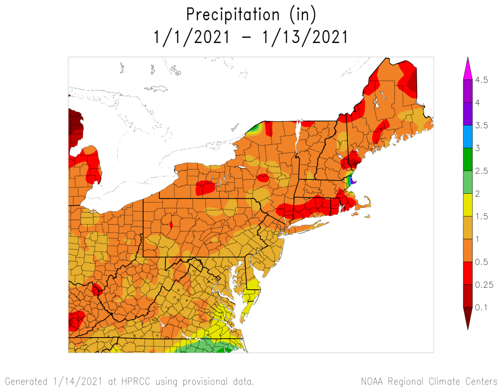
Most of the region has received less than 1 inch of liquid precipitation so far this month. Image provided by the Northeast Regional Climate Center.
The system that brought in some rain and snow showers earlier today is pulling away and we’ll have some clearing tonight. However, it won’t last too long, as clouds will stream back in on Friday ahead of low pressure moving into the Great Lakes. This is the same system that produced heavy rain and strong winds in the Pacific Northwest a few days ago, and strong winds across the Plains and Rockies last night and today. Around here, the biggest threat will be rainfall.
The system will move into the Midwest on Friday, sending a front well ahead of it towards the East Coast. A secondary area of low pressure will develop along the front in the Mid-Atlantic states and head northward along the front. This will bring rain into the region Friday night into Saturday, some of which could be heavy. We could see a little snow to start, especially across the higher elevations from central Massachusetts into southwestern New Hampshire, but temperatures should be mild, especially on Saturday as a warm front moves through. How far north the warm front gets is still a bit of a question, but it looks like most of our area should get into the mild air, with temperatures well into the 40s Saturday morning and early afternoon, possibly topping 50 in spots. While it will still be breezy, especially along the South Coast behind the warm front, the strongest winds will likely be on Sunday, behind a cold front.
Saturday’s system could produce a decent amount of rain around here. Image provided by weathermodels.com
The rain ends Saturday afternoon with the passage of that cold front, but skies probably won’t completely clear. High pressure will try to build in at the surface, but an upper-level low pressure system will make its way eastward, crossing our area later Sunday into Monday. This will keep plenty of clouds around, but with drier air moving in, only a few rain or snow showers are possible, mainly on Monday.
Friday: Some morning sun, then clouds return. High 37-44.
Friday night: Cloudy and becoming breezy with showers developing, possibly some wet snow from the hills of Worcester County into the Monadnocks of southwestern New Hampshire. Low 30-37 during the evening, then temperatures rise after midnight.
Saturday: Cloudy and windy in the morning with rain likely, possibly heavy at times, ending in the afternoon, possibly followed by some late-day clearing. High 44-51.
Saturday night: Becoming partly cloudy and breezy. Low 27-34.
Sunday: Partly sunny and breezy. High 37-44.
Sunday night: Partly cloudy. Low 23-30.
Monday: Intervals of sun and clouds, still breezy, slight chance for a sprinkle or a flurry. High 34-41.
We’ve got a very quiet weather pattern across the region for the next several days.
High pressure is providing us plenty of sunshine afternoon. Loop provided by the College of DuPage.
A chilly night is expected tonight with high pressure in control. Clear skies and light winds will allow for some radiational cooling, with some places dropping into the teens. Friday features sunshine, but a weak cold front will move through. It will have little moisture associated with it, so aside from a few snow showers in northern New England, you won’t really notice it. For Saturday, a storm system will pass well to the south, sending some clouds our way, but little else, as it will be too far south to have any other impacts. High pressure then returns for Sunday and Monday with dry and seasonably cool conditions.
Tranquil weather is expected through the weekend. Loop provided by WeatherBell.
Thursday night: Clear skies. Low 17-24.
Friday: Plenty of sunshine. High 33-40.
Friday night: Clear to partly cloudy. Low 18-25.
Saturday: A mix of sun and clouds. High 30-37.
Saturday night: Partly cloudy. Low 19-26.
Sunday: Partly sunny. High 31-38.
Sunday night: Partly cloudy. Low 16-23.
Monday: Sunshine and some afternoon clouds. High 33-40.
As we get into the final days of the year and start of a new year, we’ve got a fairly complex weather pattern shaping up across the region.
A warm front will move across the region tonight, but little precipitation will accompany it. What you will notice is that temperatures will bottom out this evening, then rise as we head through the overnight hours. Low pressure will move into the St. Lawrence Valley early on Thursday, dragging a cold front across the region during the morning. Some showers will accompany that front, but they’ll be gone by midday. High pressure then builds in, allowing skies to clear out in the evening. So, if you have any New Year’s Eve plans, weather won’t be an issue, though it will be on the cold side, as you’d expect at the end of December.
Temperatures should be in the middle to upper 20s under clear to partly cloudy skies at midnight Thursday night. Image provided by WeatherBell.
New Year’s Day starts off sunny and chilly, but clouds stream back in during the afternoon ahead of low pressure moving into the Great Lakes. We’ll see precipitation moving in towards midnight, but with cold air in place, things will be tricky. Along the coast, we’re looking at just a chilly rain, but across interior sections, it’ll be a different story. We’ll likely see it start off as snow, with some minor accumulations (an inch or two), especially from the Merrimack Valley and central Massachusetts into southern New Hampshire.
A little snow may accumulate early Saturday morning across the region, Image provided by WeatherBell.
Eventually, a change to sleet and freezing rain is expected across the interior as milder air moves in aloft. Milder air will also move in at the surface, so precipitation should change over to plain rain everywhere by Saturday morning, but before that happens, a period of freezing rain could result in some slippery travel across the interior before daybreak Saturday. The rain ends by midday, then we’ll see some clearing by late afternoon. This will also be short-lived.
The GFS model shows the progression of the Friday night storm. Loop provided by the College of DuPage.
Clouds come back in on Sunday as a storm system starts to move up the East Coast. There is still plenty of uncertainty with the track of this system, but a period snow or rain is looking likely for late Sunday into early Monday, especially across southeastern Massachusetts. We should have more clarity on this system once the Friday night system moves past the region.
There are discrepancies among the models in regards to our Sunday night storm. Images provided by Pivotal Weather.
Wednesday night: Cloudy and breezy with showers developing after midnight. Low 31-38 during the evening, temperatures rise overnight.
Thursday: Showers ending in the morning, some clearing develops late in the day. High 41-48.
New Year’s Eve: Becoming clear to partly cloudy. Low 19-26.
New Year’s Day: Sunny in the morning, clouds return in the afternoon. High 34-41.
Friday night: Cloudy with rain developing after midnight across the South Coast. Inland, snow will develop, changing to sleet, freezing rain, and eventually plain rain from south to north. Low 28-35 during the evening, temperatures rise overnight.
Saturday: Any remaining wintry mix across the interior changes to plain rain early, ending by midday. Some sunny breaks develop in the afternoon. High 35-42 north and west of I-495, 43-50 elsewhere.
Sunday night: Partly cloudy. Low 25-32.
Sunday: Cloudy with rain or snow possible late in the day. High 36-43.
Sunday night: Cloudy with a chance of rain or snow. Low 27-34.
Monday: Rain or snow ending in the morning, some clearing late in the day. High 35-42.