The heat will relent for the weekend, but the humidity will take a bit longer.
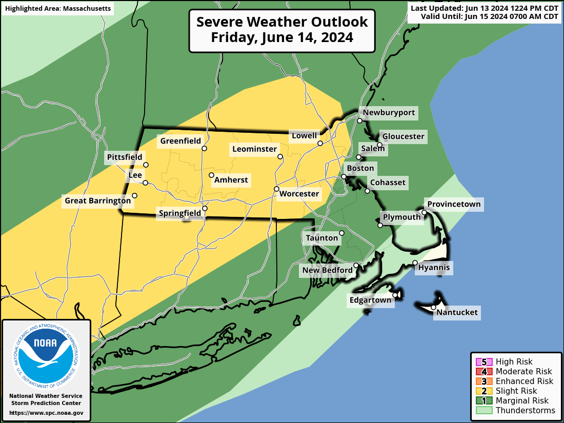
Today will be the last hot and humid day for a bit across the region, with some strong to severe thunderstorms bringing an end to the heat this afternoon and evening. The main threats with these storms are heavy downpours and gusty winds. Tonight will remain warm, but a backdoor cold front moves through on Friday, ushing much cooler air in, as winds shift into the northeast, and blow in over the still relatively cool Atlantic. Highs on Friday will only be in the 70s and 80s, warmest near the South Coast, where we’ll still get warm in the morning before the front moves through. Dewpoints will drop a bit, but will likely remain in the 60s, so it’ll be on the humid side still. Some showers are likely ahead of the front as well. The front stalls out near or just south of the region on Saturday, resulting in a rather comfortable day, but with a decent amount of clouds. On Sunday, that front will try to lift northward as a warm front once again, bringing the very warm and humid air back in. However, a disturbance moving in from the west will likely help to produce some showers and thunderstorms during the afternoon and evening. A cold front moves through on Monday, with warm, humid conditions ahead of it in the morning, along with more showers and thunderstorms, then cooler and drier air starts to move in by late in the day behind the front.

Thursday night: Showers and thunderstorms ending shortly after sunset, remaining partly to mostly cloudy overnight. Low 65-72.
Friday: Partly sunny with some showers likely. High 82-89 in the morning, turning cooler in the afternoon.
Friday night: Mostly cloudy, a few additional showers, mainly during the evening. Low 61-68.
Saturday: More clouds than sun, a few showers possible. High 77-84, a little cooler along the coast, especially the North Shore and NH Seacoast.
Saturday night: Mostly cloudy, chance for a shower. Low 60-67.
Sunday: Intervals of clouds and sun, breezy, showers and thunderstorms possible late in the day. High 83-90, cooler across the South Coast and Cape Cod.
Sunday night: Partly to mostly cloudy, showers taper off during the evening. Low 65-72.
Monday: A mix of sun and clouds, some showers around during the morning. High 79-86, a little cooler across Cape Cod.