A frontal system will be hanging around through the weekend, with its exact location determining our weather each day.
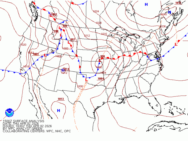
A wavy frontal system separates chilly air to the north from very mild air to the south across the eastern half of the nation. Image provided by the Weather Prediction Center.
That front is well to our south this afternoon, with some rather chilly air in place, while weak disturbances will bring in some showers this afternoon and tonight. As a low pressure system moves into the Great Lakes and then southeastern Canada tonight and Friday it will drag that front back northward, resulting in a return of milder air, with some sunshine possible Friday afternoon. This should result in some rather nice weather for the Red Sox home opener, though the day may start gloomy and cool. However, our warm weather will be short-lived, as the front drops back southward on Saturday, bringing the cooler air back, though we’ll likely remain on the dry side. Another low pressure system heads into the Great Lakes for Easter Sunday, bringing the front northward once again, so the rollercoaster ride will continue, with temperatures turning milder once again. That system brings in some rain for Sunday and Sunday night before it drags the cold front through, with, you guessed it, colder air returning on Monday.
The home opener at Fenway means summer isn’t far away.
Thursday night: Plenty of clouds with some drizzle and fog as well as some widely scattered showers, mostly after midnight. Low 30-37.
Friday: Morning clouds, maybe a lingering shower, becoming partly sunny and breezy in the afternoon. High 58-65, cooler across the South Coast and Cape Cod.
Friday night: Variably cloudy. Low 46-53.
Saturday: Partly sunny with increasing and thickening afternoon clouds, breezy. High 56-63 in the morning, temperatures drop through the daytime.
Saturday night: Mostly cloudy. Low 35-42.
Sunday: Cloudy and breezy with showers likely. High 58-65, cooler across the South Coast and Cape Cod.
Sunday night: Showers end in the evening, gradual clearing overnight. Low 33-40.
Monday: A mix of sun and clouds, breezy. High 46-53.
The final weekend of March will be mostly dry, but on the chilly side.
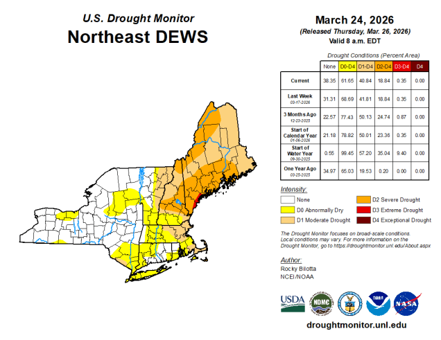
Drought conditions remain in place for much of the Northeast. Image provided by the National Drought Mitigation Center.
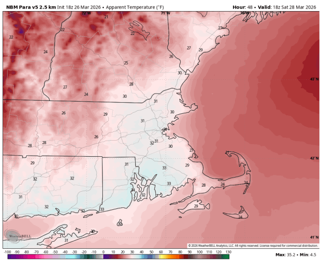
A cold front will drop southward across the region tonight, bringing some rain into the region, which is good, since we need as much as we can get with the drought ongoing. The rain will end Friday morning as the front settles offshore, then gusty northwest winds will usher much cooler air back in. Saturday will be a rather chilly day with an upper-level disturbance generating some afternoon clouds and possibly a few rain or snow showers. Temperatures will only be in the 30s, and wind chills will likely be in the 20s. High pressure then slides offshore for Sunday with sunshine and moderating temperatures, though still a little below normal for late March. We’ll continue the warmup with dry weather on Monday.
Wind chills will be in the 20s and lower 30s Saturday afternoon. Image provided by WeatherBell.
Thursday night: Cloudy with rain likely, tapering off late at night. Low 36-43.
Friday: Any lingering showers end in the morning, becoming partly to mostly sunny and breezy in the afternoon. High 43-50.
Friday night: Clear during the evening, partly cloudy overnight. Low 21-28.
Saturday: Partly sunny, breezy, chance for a few afternoon rain or snow showers. High 32-39.
Saturday night: Becoming clear. Low 21-28.
Sunday: Sunshine and some afternoon clouds, breezy. High 42-49.
Sunday night: Partly to mostly cloudy. Low 31-38.
Monday: Intervals of clouds and sun, breezy. High 54-61, a little cooler across Cape Cod and the South Coast.
Spring officially begins at 10:46am on Friday, but that doesn’t really mean that we’re done with winter weather.
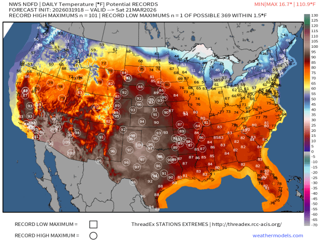
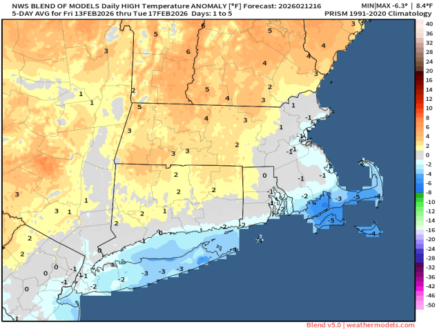
Record highs and summerlike temperatures are likely this weekend across a majority of the nation…..except the Northeast and Great Lakes. Image provided by weathermodels.com
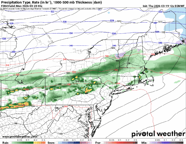
While the rest of the nation gets an early taste of summer for the next few days, here in New England, we’re reminded that Spring is usually delayed compared to everywhere else. A weak system will pass north of the region tonight generating some clouds and possibly a few flurries, favoring areas north of Route 2. We’ll clear out late at night, but clouds will quickly move back in Friday afternoon as another low pressure system heads our way. We’ll see some rain moving in by evening, ending around daybreak Saturday. We’re not expecting heavy rain from this, but every little bit helps put a dent in the ongoing drought. While we should see some sunny breaks developing Saturday afternoon, plenty of clouds will hang around as yet another system heads our way. This system could be a little trickier. Some models show a mild day with temperatures topping 60 before some rain moves in during the afternoon ahead of a cold front. Other say that it might be cold enough to start as some snow across parts of southern New Hampshire or even the Merrimack Valley, changing to rain, then back to snow or sleet behind the cold front from the Mass Pike northward before everything winds down early Monday. We’re going to lean towards the milder scenario for now, but with low confidence. Gradual clearing is expected during the day Monday as the cold front pushes offshore.
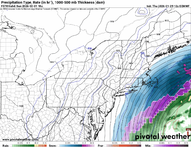
The models all have different ideas for what to expect Sunday evening. Images provided by Pivotal Weather.
Thursday night: Partly cloudy, slight chance for a flurry north of Route 2. Low 27-34.
Friday: Morning sun, then clouds stream back in, rain developing late in the day, becoming breezy. High 47-54.
Friday night: Periods of rain and showers, ending before daybreak. Low 35-42.
Saturday: Intervals of clouds and sunshine. High 47-54.
Saturday night: Partly to mostly cloudy. Low 31-38.
Sunday: Plenty of clouds with showers developing in the afternoon. High 47-54.
Sunday night: Rain may change to snow and/or sleet before ending overnight, especially north of the Mass Pike. Low 30-37.
After an early taste of Spring this week, Mother Nature is going to remind us that it’s still March, and astronomical Spring doesn’t start for another week.
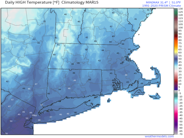
Average high temperatures for mid-March are in the middle 40s. Image provided by weathermodels.com
A wave of low pressure will ride along the cold front that crossed the region earlier today, bringing in some additional precipitation this evening. We’ll see rain changing over to sleet and then snow during the late afternoon and evening, ending before midnight. Some places could see a coating to perhaps an inch of accumulation, mainly on grassy surfaces, before everything winds down. We’ll see some clearing overnight, but clouds quickly move back in on Friday. A fast-moving system will bring in some snow or rain showers Friday evening. There probably won’t be much accumulation, and what little there is, will be mainly on grassy surfaces, and mainly north of Route 2. Gusty winds behind the system will bring colder air back in for Saturday, with wind chills in the 20s and 30s during the daytime as air temperatures only get into the lower to middle 40s. Sunday looks to be a dry and seasonably cool day, but more changes are coming.
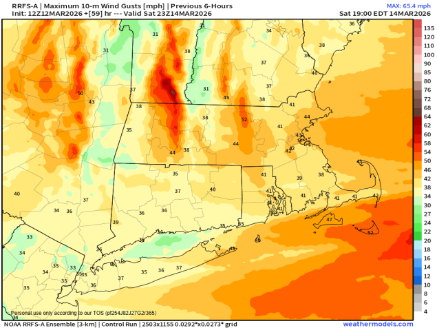
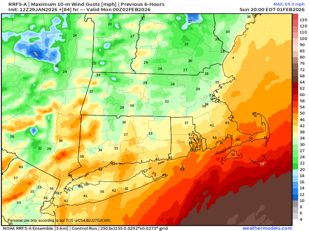
Wind gusts of 35-45 mph or higher are expected Saturday afternoon. Image provided by Weathermodels.com
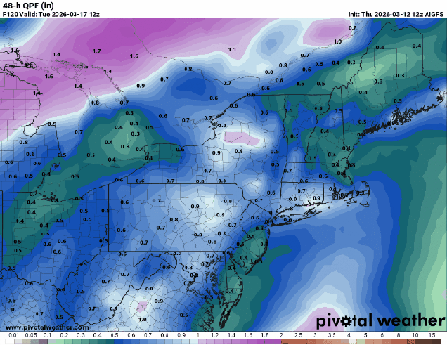
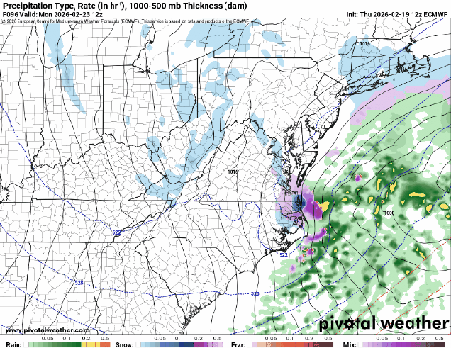
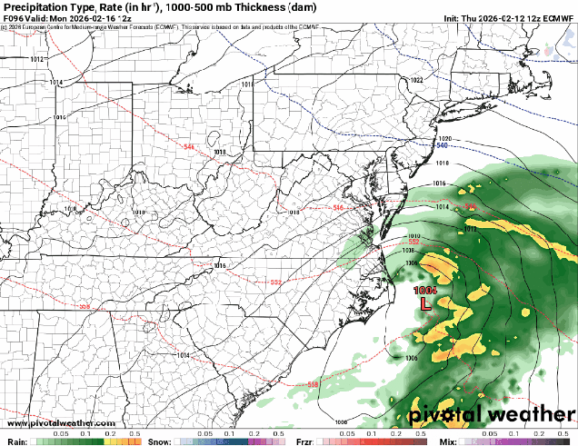
A storm system that may produce blizzard conditions across the Great Lakes will begin heading towards southeastern Canada later Sunday. We’ll see some rain moving in Sunday night ahead of a warm front. Once the front moves through, rain will taper off Sunday morning, with gusty southerly winds bring much warmer air back in, with many places likely reaching 60 again on Monday. As a cold front trailing the system heads our way, we’ll see rain moving back in late in the day, and it could be heavy, with a rumble of thunder possible as well. While we do need the rain to help put a dent in the ongoing drought, the ground remains frozen in much of the region, so a lot of the rain won’t seep in. Many rivers are also running high due to some recent rain and melting snow, so another round of heavy rain could lead to some flooding.
Much of the region could see an inch or more of rainfall on Monday. Images provided by Pivotal Weather.
Thursday night: Snow, sleet, and rain ending during the evening, less than 1 inch accumulation, mainly on grassy surfaces, skies clear out overnight. Low 24-31.
Friday: Sunny in the morning, clouds return in the afternoon, snow or rain showers possible by evening, becoming breezy. High 36-43.
Friday night: Partly to mostly cloudy and breezy with some snow or rain showers likely, mainly north of Route 2, and mostly before midnight. Low 30-37.
Saturday: Sunshine and a few clouds, windy. High 40-47.
Saturday night: Clear skies, clouds may start to move back in late at night. Low 23-30.
Sunday: Becoming partly to mostly cloudy. High 38-45.
Sunday night: Cloudy with rain developing. Low 31-38 during the evening, temperatures start rising after midnight.
Monday: Rain tapers off early, then mostly cloudy and windy with more rain by late in the day, possibly a rumble of thunder. High 54-61, coolest across the South Coast and Cape Cod.
A rather messy storm will impact the region tonight and Friday, but milder weather is on the way.
A wintry mess is on the way for tonight and Friday morning. Image provided by the National Weather Service office in Norton, MA.
A frontal system is stalled out south of the region as high pressure in Atlantic Canada sends cold weather our way once again. Meanwhile, low pressure moving across the Midwest is sending some rain our way through the afternoon. As the colder air continues to filter in this evening, first at the surface, and then aloft, we’ll see rain changing to sleet, and possibly some freezing rain, mainly north of the Mass Pike, with mostly rain to the south. The best chance for freezing rain will be across the hills in Worcester County up into the Monadnocks of southwestern New Hampshire. As the colder air moves in aloft, a change to snow is expected, with rain changing to sleet south of Boston, though areas near the South Coast will likely stay mostly rain. Precipitation winds down Friday morning as the wave of low pressure pulls away. We’re looking at 2-4 inches of snow and sleet across southern New Hampshire and northern Massachusetts, mainly north of Route 2, with a coating to 2 inches south of there. Friday afternoon and evening will be cloudy, chilly, and damp, with some drizzle or freezing drizzle at times.
A wintry mess will create problems for the Friday morning commute. Loop provided by WeatherBell.
Saturday will be the start of the transition to milder weather. A stronger low pressure system will head into the Great Lakes, with southwest winds developing ahead of it. The clouds will hang tough for much of the day, though there could be a few sunny breaks, but temperatures will turn milder, likely topping 50 in many areas, though areas near the South Coast will stay in the 40s, as a southwest wind will be blowing off of the still-chilly Atlantic. A warm front moves through Saturday night, accompanied by a few rain showers, but it will keep temperatures mild through the night, likely staying in the 40s or even 50s during the overnight hours, helping to melt the snow we still have on the ground. A cold front moves through Sunday morning, possibly with another shower or two, but we’ll clear out behind it, with temperatures remaining mild, well into the 50s inland, 40s near the South Coast. High pressure then builds in for Monday with sunshine and mild temperatures, possibly reaching 60 in a few spots.
Monday is shaping up to be a fantastic day across the region. Image provided by weathermodels.com
Thursday night: Cloudy with rain likely, changing to sleet/freezing rain north of the Mass Pike, and eventually snow north of Route 2. Low 27-34.
Friday: Snow, sleet, freezing rain, and rain ending during the morning, cloudy with some drizzle or freezing drizzle and fog through the afternoon, breezy at times. Snow and sleet totals 2-4 inches north of Route 2, a coating to 2 inches south of Route 2, little to no accumulation across southeastern Massachusetts and southern Rhode Island. High 32-39.
Friday night: Plenty of clouds, some drizzle or freezing drizzle likely along with more fog. Low 29-36.
Saturday: Clouds and a few sunny breaks. High 43-50.
Saturday night: Mostly cloudy with a few showers, becoming breezy. Low 38-45 in the evening, temperatures rise overnight.
Sunday: Morning clouds and fog, possibly a shower, then becoming partly to mostly sunny in the afternoon. High 50-57, cooler across Cape Cod.
Sunday night: Clear skies. Low 31-38.
Monday: Sunshine and a few clouds. High 55-62, cooler across the South Coast and Cape Cod.
For a change, we’ve got a mostly quiet weekend coming up across the region.
Temperatures could reach 50 in some areas Saturday afternoon. Image provided by WeatherBell.
High pressure settles in for tonight into Saturday with mostly dry weather. Temperatures will remain seasonably cool into Friday, but as the high moves off to the east, southwest to south winds will send milder air in, with some places possibly reaching 50 on Saturday, helping to start melting the glacier currently occupying most of New England. A cold front will move in early Sunday, accompanied by some light snow or snow showers during the morning hours. A few spots could pick up an inch or even two, but overall this is not a big deal. Temperatures start to drop behind the front in the afternoon, then we’ll see some clearing for Sunday night. A wave of low pressure passes well south of the region along the front on Monday, but it will keep some clouds in place.
A little bit of snow is expected Sunday morning. Image provided by weathermodels.com
Thursday night: Evening clouds, then becoming clear. Low 9-16, a little milder across urban areas and Cape Cod.
Friday: Plenty of sunshine. High 33-40.
Friday night: Clear to partly cloudy. Low 22-29, temperatures start to rise after midnight.
Saturday: Partly to mostly sunny. High 42-49.
Saturday night: Partly cloudy. Low 24-31.
Sunday: Light snow or snow showers during the morning, a coating to 2 inches is possible, skies start to clear out late in the day. High 30-37. temperatures start to drop in the afternoon.
A pair of low pressure systems make for a complicate forecast across the region.
A messy storm is on the way for Friday into part of Saturday. Loop provided by WeatherBell.
Clouds will stream back into the region tonight ahead of a low pressure system moving out of the Great Lakes. Precipitation will develop late Friday morning or early Friday afternoon. Temperatures will be close to freezing, but warmer air will move in aloft, so we’ll see sleet and some freezing rain across much of the region at the onset. The exceptions will be near the South Coast, where it will be plain rain as temperatures will be milder, and across central New Hampshire, where precipitation falls mainly as snow. During the day, a secondary area of low pressure will develop south of New England, and as it moves by at night, it will drag colder air southward, changing the precipitation over to snow from north to south. The system pulls away during the day Saturday, with some occasional snow showers likely not winding down until the afternoon. How much snow/sleet are we expecting? Much of Rhode Island and southeastern Massachusetts will see less than 1 inch. Areas roughly north of Route 44 up to the Mass Pike will see 1-2 inches. North of the Pike we’re looking at 2-4 inches, with a little more, possibly 3-6″ from the hills of Worcester County up into southern and central New Hampshire.
Once the mix changes over to snow, a few inches are likely in many areas. Image provided by weathermodels.com
High pressure briefly builds in for Saturday night and Sunday, then we turn our attention to a low pressure system that will be developing near the Mid-Atlantic coastline. There is still considerable uncertainty with this storm in not only the track, but how strong it will get. This will determine how strong the winds get around here, whether there will be any coastal flooding, and of course, how much, if any, snow we’ll get. Right now, it looks like the storm will pass just far enough offshore so that the only places with a chance for some heavier snow will be across Cape Cod and southeastern Massachusetts. However, there are some models that do bring heavier snow farther inland, so we can’t discount that possibility just yet. Of course, this could also end up like last weekend’s storm that passes so far offshore that only Nantucket had any snow. Either scenario is plausible at this point, and if it looks like a significant storm is more likely, we’ll write a special blog post on Sunday.
Is there a storm in our future for Sunday night and Monday? The models don’t agree. Images provided by Pivotal Weather.
Thursday night: Becoming partly to mostly cloudy. Low 22-29.
Friday: Cloudy with a wintry mix of snow, sleet, freezing rain, and rain developing around midday. High 33-40.
Friday night: Mix changing to light snow and show showers from north to south. Low 23-30.
Saturday: Cloudy with snow showers ending during the afternoon. High 31-38.
Saturday night: Some clearing after midnight. Low 14-21.
Sunday: Any morning sun disappears behind thickening clouds. High 30-37.
Sunday night: Cloudy and becoming windy with a chance of snow, mainly south of Boston. Low 21-28.
Monday: Mostly cloudy and windy with any snow ending. High 29-36.
This weekend will be something of a rarity for this winter – no big snowstorms and no bitterly cold temperatures.
Temperatures will be fairly close to normal for mid-February this weekend. Image provided by Weathermodels.com
High pressure will build in, keeping us dry and seasonably cool into Friday night. A weak system will move across the region early on Saturday, but it won’t have much moisture to work with. It could produce a few flurries, but for the most part, we’ll stay dry. High pressure returns later Saturday into Sunday, then we’re going to be watching a storm system moving out of the Mid-Atlantic states. This storm was the subject of plenty of hype earlier this week, but that hype seems to have gone away. Perhaps because most of the models keep the storm well south of New England now, with little to no impact other than some clouds later Sunday into Monday? Sure, there are still 1 or 2 outlier models that bring a little snow to parts of Southern New England, but they are just that – outliers. Unless something radically changes in the next day or two, our forecast will show it staying dry.
Despite earlier hype, low pressure should stay well south of New England on Monday. Images provided by Pivotal Weather.
Thursday night: A few clouds around. Low 10-17.
Friday: Mostly sunny. High 30-37.
Friday night: Becoming partly to mostly cloudy, chance for a few late-night flurries. Low 14-21.
Saturday: Morning clouds, maybe a flurry, then becoming partly to mostly sunny in the afternoon. High 33-40.
Saturday night: Clear to partly cloudy. Low 15-22.
Sunday: Mostly sunny in the morning, then increasing afternoon clouds. High 31-38.
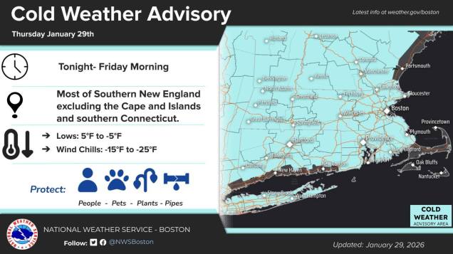
We’re going to separate fantasy from reality in regards to a potential weekend storm, but first we’ve got some very cold weather to deal with.
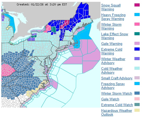
Cold Weather Advisories are in effect for most of the region. Image provided by the National Weather Service office in Norton, MA.
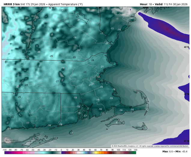
If it hasn’t been cold enough for you this week, then we have good news for you – it’s going to get even cold for the next couple of days. A reinforcing shot of arctic air moves in tonight on gusty north to northwest winds. Temperatures will likely drop below zero across much of the region overnight, but when you factor in the wind, it will feel like 15 to 25 below zero by morning. While the winds will only slowly slacken on Friday, and we’ll have plenty of sunshine, it will remain quite cold, with highs likely staying in the teens. Another very cold night is expected Friday night, and with diminishing winds, some radiational cooling is expected, so we’ll once again drop below zero in much of the region. Saturday will also be chilly, but not as cold as Friday, with highs likely getting into the 20s. We’ll also have more sunshine, but high clouds will start to stream in during the afternoon and evening ahead of a low pressure system developing off the Southeast coast.
Bitterly cold wind chills are expected Friday morning. Image provided by WeatherBell.
Despite the hype all week, we are not expecting another major snowstorm for much of the region at this point. Oh, it could still happen, but the odds continue to decrease for most (but not all) of the region. As the low heads northward on Sunday, it will rapidly strengthen – you’ve probably heard the term “bombogenesis” used. This term has been around for a long time, and the definition is a storm whose lowest pressure falls by 24mb or more over a 24 hour period. If you look at your home barometer, it’s probably reading around 29.9″ of mercury right now, which is about 1013mb. The low pressure system that will spawn our ocean storm is currently over northern Texas with a minimum pressure of 1015mb. By the time it reaches the Carolina coast, it should be down to around 1008mb. When it passes well south and east of New England Sunday night, it should be down to about 965-970mb. When a storm strengthens like that, the gradient between it and high pressure to the north will result in very strong winds, especially near the coast. This will be the case around here for Sunday and into Monday. We’re also near the astronomical high tides, so for northeast and north-facing coastal locations, some coastal flooding is possible with the high tides Sunday morning and again Monday morning.
Wind gusts in excess of 40 mph are possible on Sunday, especially along the coast. Image provided by Weathermodels.com
OK, it’s going to be cold, it’s going to be windy, there could be flooding issues along the coast, but what about snow? Well, the models aren’t in complete agreement yet, but they’re getting there, in terms of the potential for snow. For now, the system looks to be far enough offshore to prevent much of the region from a significant snowstorm. In fact, there’s a very good chance that areas north and west of Interstate 95 could see little to no snow at all. South and east of I-95, some snow is possible, becoming more likely the farther south and east you go. If anyone were to get significant snow from this, it would be Cape Cod (especially the Outer Cape), and Nantucket. Now, could the models start showing a trend closer to the coast, thus bringing more snow in farther north and west? Of course they could – the storm is still 3 days away, but at this point, it’s not looking likely. Obviously, we’ll keep a close eye on it. As the storm pulls away on Monday we’ll clear out, but winds may remain gusty.
The best chance for some snow Sunday afternoon looks to be across Cape Cod. Images provided by Pivotal Weather.
Thursday night: Evening clouds, maybe a lingering snow shower across the Outer Cape, then becoming clear and very cold. Low -4 to +3, a little milder on Cape Cod.
Friday: Sunshine and a few clouds, breezy, and cold. High 11-18.
Friday night: Mostly clear, winds diminish in the evening. Low 0 to -7, a little milder on Cape Cod.
Saturday: Sunshine dimmed by increasing afternoon high clouds. High 17-24.
Saturday night: Becoming mostly cloudy, winds start to increase late at night. Low 1-8, a little milder along the coast.
Sunday: Cloudy and windy with a chance of snow, mainly across southeastern Massachusetts and Cape Cod. High 21-28, a little milder across Cape Cod.
Sunday night: Any snow ending in the evening, some gradual clearing after midnight, winds slowly diminish. Low 12-19.
Monday: Becoming partly to mostly sunny, breezy in the morning. High 27-34.
You may have heard that there’s a little storm on the way. Well, before that happens, it’s also going to get ridiculously cold. We’ll get to all of that in this blog, but we’ll tell you right now, you won’t find a forecast for snow amounts. It’s too early for that, and there’s too much uncertainty still. We’ll tell you how we think the storm will evolve and its likely impacts around here, how cold it will get Before the Storm (and how that will impact things), and lots of musical references, but we’re not going to give you a snowfall forecast. We may do that in another blog post tomorrow, but for now, we’ll leave the hype to all of the TV meteorologists and Facebook Forecasters of the world.
A variety of watches, warnings and advisories are in effect across the eastern US. Image provided by the National Weather Service Eastern Region
After a somewhat mild day today, a cold front will move through this evening, possibly accompanied by a few snow showers, but the more noticeable effect will be cooler air moving in tonight. On Friday, an arctic cold front will cross the region, possibly with some additional snow showers or squalls, and that is what will start the Change in the Weather. Bitterly cold air will flood into the region behind that front. Temperatures will plunge into the single numbers and below zero across the region, with wind chills well below zero thanks to gusty northwest winds, making you dream about those Hot Summer Nights. A Cold Weather Advisory is in effect for much of the region. On Saturday, sunshine will start to fade as high Clouds Race Across the Sky, but it will remain Stone Cold, with high temperatures only getting into the teens at best, with wind chills still near or below zero before winds die down in the afternoon. Clouds will continue to stream in Saturday night, but it will remain chilly. This brings us to Sunday.
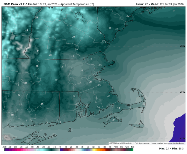
Wind chills of -10 to -20 are expected Saturday morning. Image provided by WeatherBell.
Low pressure moving into the Southwest will run into the arctic airmass covering much of the eastern two-thirds of the nation over the next few days. Moderate to heavy snow is expected from the Southern Plains across to the Tennessee Valley and parts of the Southeast and Mid-Atlantic states. To the south of these areas, a significant sleet and freezing rain storm is likely from parts of Texas into the Deep South. Places like Dallas, Little Rock and perhaps Nashville and Atlanta could be Trapped Under Ice by the end of the weekend. By Sunday, that system will move off the Carolina coast and head northeastward, developing as it passes south and east of Cape Cod early Monday. Sunday will start off cloudy and cold, with snow likely moving in by mid-to-late afternoon from southwest to northeast. With some very cold air in place, it will be more of a fluffy snow, easier to clean up, but it also piles up a lot more quickly. Snow will continue through the night, possibly heavy at times, slowly winding down during the day on Monday. The questions now are:
How much does the very dry air in place slow down the start of the snow on Sunday?
How heavy does the snow fall at times Sunday night into Monday?
When will the snow actually end?
How close will the system actually track to the coast?
Will temperatures get up close to freezing across parts of southeastern Massachusetts behind a coastal front?
Could there be some sleet and/or rain near the South Coast and Cape Cod?
With this many questions that we don’t have answers to at this point, it would be irresponsible to try and forecast snowfall totals, so we won’t do that. We will say that it is likely that much of the region gets 6 inches or more, but beyond that, we won’t commit to anything else.
After some snow showers/squalls tonight and Friday, you see the snow spreading in on Sunday. Loop provided by Weathermodels.com
Thursday night: Partly to mostly cloudy, chance for a few snow showers, skies start to clear out late at night. Low 16-23.
Friday: A mix of sun and clouds, chance for some snow showers or squalls, breezy. High 27-34.
Friday night: Becoming clear, breezy, and bitterly cold. Low -3 to +4, a little milder across Cape Cod.
Saturday: Sunny and breezy in the morning, high clouds stream in during the afternoon. High 10-17.
Saturday night: Becoming mostly cloudy. Low -1 to +6.
Sunday: Cloudy with snow developing by mid-to-late afternoon. High 13-20 north and west of I-95, 21-28 south and east.
Sunday night: Snow likely, possibly mixed with a little sleet or rain near the South Coast and Cape Cod, becoming breezy. Low 8-15 north and west of I-95, 16-23 south and east.
Monday: Snow gradually ending, breezy. High 16-23 north and west of I-95, 24-31 south and east.