Tropical Update – Things Are Getting Active

The tropics in the Pacific and Atlantic can be described using the titles of two of Shakespeare’s plays – “The Tempest” for the Eastern Pacific Ocean, and “Much Ado About Nothing” for the Atlantic Ocean.

Hurricane Hilary has been downgraded to a Tropical Storm as it continues northward very close to the coast of the Baja California peninsula. As of 11am EDT, Hilary was centered about 220 miles south-southeast of San Diego, moving toward the north-northwest at 25 mph. Maximum sustained winds are near 70 mph. Tropical Storm Warnings remain in effect for northern portions of the Baja California peninsula, as well as the southern California coast from the Mexican border northward to Point Mugu, including Catalina Island.

Satellite loop of Tropical Storm Hilary. Loop provided by NOAA.

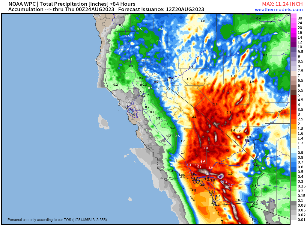
Hilary is expected to continue weakening today as it passes very close to the Baja coastline and into southern California. Despite the hype over the past few days, Hilary will probably not make landfall in southern California, but instead across extreme northwestern Mexico, with the center moving into southern California farther inland, but still as a tropical storm. Hilary will produce gusty winds and storm surge along the coast, with a few tornadoes possible across parts of the Southwest, but heavy rain and the resultant flooding are the most significant threat with this storm. Rainfall totals of 3-6 inches are likely across many locations in southern California and Nevada, with some totals in excess of 10 inches possible. In some of the desert locations, including Death Valley, this is more rain than they normally receive in an entire year. Widespread flooding is likely, including the San Diego, Los Angeles, and Las Vegas metropolitan areas. As Hilary continues to push northward and weakens, heavy rain will spread across the Great Basin, and Inland Northwest, with rainfall totals of 1-3 inches possible, likely producing some flooding in these areas as well.

In the Atlantic, Saharan Dust has suppressed activity for the past few weeks, but now that it has moved out, there are several areas of interest, including a pair of storms.

Tropical Storm Emily has developed about 1000 miles west-northwest of the Cabo Verde Islands, moving toward the west-northwest at 10 mph. Maximum sustained winds are near 50 mph. Emily is expected to continue toward the west-northwest for the next day or two, but conditions will become increasingly hostile, with wind shear increasing over the next few days, which will basically rip the system apart. This will result in steady weakening of Emily, with it likely become extratropical on Monday or Tuesday. After that it will turn toward the northwest and north, heading out into the open waters of the Atlantic, without impacting any land areas.

Satellite loop of Tropical Storm Emily. Loop provided by Tropical Tidbits.

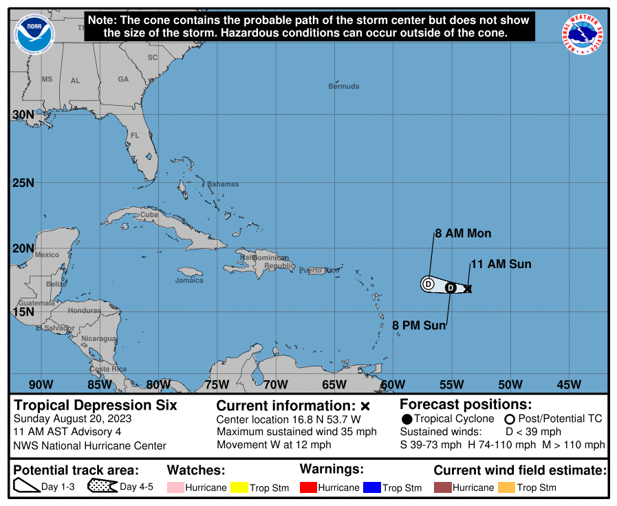
Tropical Depression Six is barely hanging on as an organized system about 625 miles east of the Northern Leeward Islands. Top winds are near 35 mph, and it is moving toward the west at 12 mph. Wind shear is ripping this system apart, and it is expected to dissipate over open water later today or tonight. At least the Hurricane Center didn’t waste a name on this piece of junk.

Another area of low pressure is moving across the southeastern Caribbean Sea this afternoon, producing numerous showers and thunderstorms across the eastern Caribbean. It should continue toward the west-northwest for the next day or two, and conditions are favorable for it to continue to develop. Reconnaissance aircraft are scheduled to investigate this system during the afternoon to check on the structure and strength of the system. It will continue to produce heavy rain and gusty winds across the northern and eastern Caribbean for the next few days, but it should turn more toward the north early this week, which will increase the threat to some of the islands, depending on when the turn occurs. Right now, it looks like Hispaniola will have the biggest threat, but this is predicated on when (or if) that turn occurs. It should eventually move north of the islands, possibly near the Turks and Caicos Islands, before heading out into the Atlantic. Once into the open waters of the Atlantic, it could become a potent storm system, but again, this is dependent on what it does in the next few days first.

An area of low pressure that brought heavy rain and thunderstorms to the Bahamas and southern Florida has moved into the Gulf of Mexico this afternoon. It is expected to continue westward across the Gulf over the next few days, with some development possible. It could become a tropical depression toward midweek before approaching the Texas coastline. Whether it develops or not, it should bring some much-needed heavy rain to parts of central and southern Texas later this week, helping to not only put a dent in the ongoing drought in the region, but also provide some relief from the heat. Of course, places like Dallas and Austin, where temperatures will be in the 100-110 range for the next few days won’t get any relief.

A system will bring much needed rainfall to parts of Texas this week. Image provided by Pivotal Weather.

Yet another tropical wave has moved off the African coast and into the eastern Atlantic. Conditions will be favorable for development over the next several days, and it could become a tropical depression later this week. If it does actually develop, it is expected to remain over open water, with no impact to land areas through at least next weekend.

Tropical Update + Weekend Outlook: June 23-26, 2023

The first weekend of summer is not going to feature much, if any sunshine, but it will be warm and humid. Meanwhile, the tropics are in mid-summer mode.

Dewpoints will be near or just above 70 across the region Saturday afternoon. Image provided by WeatherBell.

As has been the case for the past couple of months, an upper-level low will be the main driver of our weather for the next few days as it lifts northward from the Tennessee Valley into the eastern Great Lakes and then across the Northeast. Low pressure at the surface will send a warm front our way, spreading lots of clouds in tonight, with a noticeable increase in humidity on Friday as the front moves through. The front may be accompanied by a few showers and thunderstorms, but it won’t be a washout. Showers and thunderstorms may be a little more numerous on Saturday, and some of them could be locally heavy. More showers and thunderstorms are possible on Sunday as the system moves across the region and off to the east. So, things improve on Monday, right? Try again. Another upper-level low moves into the Midwest, which means unsettled conditions continue, with some additional showers and thunderstorms, and this pattern may persist for a good chunk of next week. Keep in mind, that even though there are showers and thunderstorms in the forecast every day, each day shouldn’t be a washout. They’ll be most likely during the afternoon and evening each day, but it doesn’t mean they’ll cover the entire area.

Despite the showers and storms forecast each day this weekend, most of the models are not showing an excessive amount of rainfall. Images provided by Pivotal Weather.

Meanwhile, in the tropics, things have gotten active. Thanks to sea surface temperatures more reminiscent of late August than late June, two tropical systems have developed from waves moving off the African coast. We usually don’t see storms of this type begin to develop until late July or August, and to have two of them in June is extremely rare. The more immediate concern is Tropical Storm Bret. As of 2pm Thursday, Bret was centered about 45 miles east-northeast of Barbados, moving toward the west at 14 mph. Maximum sustained winds were near 65 mph. Barbados has already reported wind gusts as high as 52 mph. Tropical Storm Watches and Warnings are in effect for many of the islands in the Lesser Antilles. Bret has likely peaked in intensity, but it will bring very squally conditions to the islands as it moves through later today and tonight. Once it moves into the eastern Caribbean on Friday, increasing wind shear will begin to rip the system apart, and it should weaken and degenerate into a tropical wave over the weekend as it moves into the central Caribbean.

As Bret approaches the Lesser Antilles, the wind shear is evident as most of the thunderstorm activity is displaced east of the center. Loop provided by NOAA.

Meanwhile, Tropical Depression Four has developed in the Central Atlantic. As of 11am Thursday, it was centered about 1270 miles east of the Lesser Antilles, moving toward the west-northwest at 15 mph. Maximum sustained winds were near 35 mph. This system should strengthen into Tropical Storm Cindy over the next day or so, and will continue to strengthen through Saturday. However, after that, increasing wind shear will begin to take its toll on this system as well, and it will begin to weak. The track should bring in more toward the northwest with time, meaning it will stay over the open waters of the Central Atlantic, and not impact any land areas.

None of the models show TD 4 as a threat to any land areas over the next 3-5 days. Image provided by Tropical Tidbits.

Thursday night: Becoming mostly cloudy with areas of fog likely, a shower or two is possible. Low 54-61.

Friday: Partly to mostly cloudy, much more humid, chance for a few showers, mainly across the interior. High 74-81.

Friday night: Mostly cloudy, a shower is possible, mainly during the evening. Low 62-69.

Saturday: Partly to mostly cloudy, showers and thunderstorms expected in the afternoon. High 75-82.

Saturday night: Plenty of clouds, a few showers around. Low 62-69.

Sunday: Clouds with some sunny breaks, more showers and thunderstorms possible. High 78-85.

Sunday night: Partly to mostly cloudy, some additional showers likely, especially during the evening. Low 61-68.

Monday: Partly to mostly cloudy with more showers and thunderstorms likely. High 77-84.

Weekly Outlook: June 19-25, 2023

Astronomical summer begins at 10:57am Wednesday, and right on cue, some summer weather will move into the region by then.

Astronomical summer officially begins Wednesday morning. Image provided by Earth.com

The week starts off with yet another upper-level low in place across the Northeast, which means we’ll have plenty of clouds generated each day along with some showers during the afternoon and evening hours. Showers may continue for a good chunk of the night tonight as another disturbance rotates around that upper-level low. Temperatures will remain on the cool side for mid-June, especially near the coast, where a seabreeze is likely. By Wednesday, the upper-level low moves away, and a ridge of high pressure builds into the East Coast. As a result, we’ll turn drier and warmer, with temperatures likely getting into the 80s in many locations, possibly approaching 90, especially on Friday. With the warmth will come increasing humidity levels, especially over the weekend, and which may allow for a few thunderstorms to pop Friday afternoon. The ridge starts to break down over the weekend as a disturbance moves toward the region, likely producing some showers and thunderstorms. Showers and thunderstorms become a little more numerous on Sunday ahead of a cold front dropping down from the north.

Dewpoints could climb into the lower 70s around here by next Saturday. Images provided by Weathermodels.com

On a separate note, the tropics are starting to show signs of life. Aided by sea surface temperatures more reminiscent of late August than mid-June, a tropical wave that moved off the coast of Africa a few days ago has been slowly organizing over the weekend, Conditions are favorable for further development, and it will likely become a tropical depression at some point later today or Tuesday. Its immediate future calls for a westward track with gradual strengthening, and no threat to land for much of the upcoming week. As we get to the end of the week, that becomes more complicated. Once the storm does form, we’ll have a more detailed blog post about it, and what its future may look like.

Many of the models quickly bring the disturbance in the eastern Atlantic to hurricane strength by midweek. Image provided by WeatherBell.

Monday: Partly sunny, chance for a few showers or thunderstorms during the afternoon and evening. High 67-74, coolest along the coast.

Monday night: Partly to mostly cloudy with showers likely. Low 52-59.

Tuesday: Partly sunny, a few more showers possible, especially during the afternoon. High 66-73, coolest along the coast.

Tuesday night: Partly cloudy. Low 52-59.

Wednesday: Partly to mostly sunny. High 70-77.

Thursday: Sunshine and a few clouds. High 77-84, coolest along the South Coast.

Friday: A mix of sun and clouds, breezy, slight chance for a late-day shower or thunderstorm. High 80-87, coolest along the South Coast.

Saturday: More clouds than sun, breezy, scattered showers and thunderstorms develop. High 80-87.

Sunday: Partly to mostly cloudy, breezy, more showers and thunderstorms expected. High 75-82.

Hurricane Season Begins Tomorrow

Hurricane Season in the Atlantic officially begins on June 1, and once again, the season got off to a very early start.

The 2022 season was a fairly normal season by the numbers, with 14 named storms, 9 hurricanes, and 3 major hurricanes, but the bulk of the activity occurred during a 10-week span between Labor Day and Veterans Day. Hurricane Ian made the most headlines, hitting the Fort Myers, Florida area as a strong Category 4 hurricane on September 28. Hurricane Fiona brought significant flooding to Puerto Rico, and then became the strongest to ever make landfall in Canada when it struck Nova Scotia as a poweful extratropical cyclone on September 24. Hurricane Nicole also made landfall near Vero Beach, Florida on November 10, but Ian and Nicole were the only systems to make landfall in the continental United States. This was a welcome change from 2021 when a total of 21 storms formed, 3rd most ever in a single season, and a total of eight of them made landfall in the United States. That includes 2 tropical storms that made landfall in New England that summer – Elsa and Henri. Both Elsa and Henri each made landfall near Westerly, Rhode Island about 6 weeks apart. This was just the 5th time since 1851 that two tropical systems made landfall in Southern New England or Long Island in the same year, and only the 2nd time (1961 being the other), that both storms were only tropical storm strength. (We’ll have more info on New England tropical systems a little later in this post).

The 2022 season wasn’t as active as previous years. Image provided by the National Hurricane Center.

Forecasts for the upcoming season are a bit more challenging than recent years. Sea surface temperatures in the Atlantic are mostly above normal, which would tend to lead toward a more active year, but an El Nino is also developing in the Pacific, and that tends to suppress Atlantic tropical activity. NOAA issued their seasonal hurricane outlook on May 25, and it calls for a 40 percent chance for a near normal season, a 30 percent chance for an above normal season, and a 30 percent chance for a below normal season. Many of the other hurricane outlooks issued by various outlets are also expecting a near normal season, due to the conflicting signals mentioned above. An average season consists of 14.4 named storms, of which 7.2 become hurricanes and 3.2 become major hurricanes (Category 3 or higher on the Saffir-Simpson scale). NOAA’s forecast for this season calls for 12-17 named storms, 5-9 hurricanes, and 1-4 major hurricanes. The Tropical Meteorology Project at Colorado State, the first group to forecast how active a hurricane season would be, originally led by the late Dr. Bill Gray, will issue their updated forecast on June 1. Their initial forecast from April called for a slightly below average season, with 13 named storms, 6 hurricanes, and 2 major hurricanes. Before last year’s near normal season, the previous 7 seasons had all featured above normal activity across the Atlantic.

List of names for storms that form during the 2023 Hurricane Season. Image provided by NOAA.

Hurricane season got off to an extremely early start this year, though most people didn’t realize it. It turns out that system that developed off the East Coast back in the middle of January was actually a subtropical storm, according to a recent statement from the National Hurricane Center. We’re still awaiting the official report on this storm to see the details of it, but since it formed after January 1, it is technically Subtropical Storm One for the 2023 season, and the next one that forms will be Tropical Depression Two. If it reaches tropical storm strength, it will be Tropical Storm Arlene, since names are not designated on storms after the fact. Despite the early start, the average date for the first named storm in the Atlantic is still June 20, and the average date for the first hurricane is August 11. Over 97% of all named storms in the Atlantic form between June 1 and November 30. Most early season storms tend to be on the weaker side. A hurricane hasn’t made landfall in the United States before July 1 since Hurricane Bonnie came ashore as a minimal hurricane near the Texas/Louisiana border on June 26, 1986.

Based on climatology, the most likely spots for an early season storm are off the Southeast coast, in the Gulf of Mexico, or the northwestern Caribbean. Image provided by the National Hurricane Center.

The number of storms that form in any given season has no correlation on how many storms (if any) will impact the United States. In 2010, 19 named storms were observed in the Atlantic, 12 of them became hurricanes, and 5 were major hurricanes. Only one storm made landfall in the United States, and that was Bonnie, which was a minimal tropical storm at landfall. In 1990, there were a total 14 named storms, 8 of them hurricanes and 1 major hurricane. Not a single one of them made landfall in the United States. On the flip side, only 7 named storms formed in 1992, and the 1st one didn’t develop until August 16. That storm, however, was named Andrew, and it made landfall just south of Miami as a category 5 storm. It only takes one storm to ruin your entire year.

Here in New England, we should always pay attention when a storm is nearing the Bahamas, as those are the ones that have the potential to impact us, and we are very overdue for a hurricane to head this way. Using data back to 1851, here are some stats that show how overdue we are:

  • Since 1851, 39 storms of tropical storm strength of greater have made landfall in New England or Long Island, an average of one every 4.4 years. The longest we’ve ever gone without one is 11 years, between 1897 and 1908 and also between 1923 and 1934. In 2021, we had two tropical storms (Elsa and Henri) make landfall in the region.
  • Since 1851, 32 strong tropical storms (maximum sustained winds of 60 mph or more) have made landfall in New England or Long Island, an average of one every 5.4 years. The longest we’ve ever gone without one is 19 years, between 1897 and 1916. In 2021, we had two strong tropical storms (Elsa and Henri) make landfall in the region.
  • Since 1851, a hurricane has made landfall in New England or Long Island 18 times, an average of one every 9.6 years. The longest we’ve ever gone between hurricane landfalls is 38 years, between 1896 and 1934. It’s been 32 years since Bob, our 2nd longest drought on record.
  • Since 1851, 8 hurricanes of Category 2 intensity or stronger have made landfall in New England or Long Island, an average of one every 21.5 years. The longest we’ve gone between hits by storms of that intensity is 69 years, between 1869 and 1938. We’re at 32 years since Bob, the last one to do so.
  • Since 1851, New England/Long Island has had 3 Major Hurricanes (Category 3 or higher) make landfall – an unnamed storm in October of 1869, the infamous 1938 Long Island Express, and Hurricane Carol in 1954. That’s an average of 1 every 57.3 years, and the longest time between 2 major hurricanes is 69 years (1869-1938). We’re at 68 years since Carol. There are also 3 documented storms from before 1851 – The Great Colonial Hurricane of 1635, the 1815 New England Hurricane, and the Norfolk and Long Island Hurricane of 1821. That’s it. That changes the numbers to 6 in 388 years, or one every 64.7 years, with a longest drought of 180 years.
Satellite photo of Hurricane Bob approaching New England. Bob was the last hurricane to make landfall in New England – 32 years ago. Image provided by NOAA.

We all saw what Sandy did back in 2012, and that was a minimal hurricane that eventually made landfall in southern New Jersey (technically as an extratropical storm). When (not if) the next big storm comes up the coast, much of this region will not be prepared for the storm or its aftermath.

The Atlantic is quiet right now, but even if something were to form off the East Coast in the next few weeks and head this way, the waters off of New England despite being warmer than normal, are still much too cold to sustain a tropical system, so we’d see something more like a typical nor’easter. Only two tropical storms have ever made landfall in the Northeast before the end of June. The first was an unnamed minimal tropical storm that crossed extreme eastern Long Island and went into southeastern Connecticut on May 30, 1908. The other was Tropical Storm Agnes, which made landfall near New York City on June 22, 1972, then caused devastating flooding across parts of the Mid-Atlantic states. In terms of hurricanes, the earliest one to ever make landfall up this way was Hurricane Belle, which slammed into Long Island with 90 mph winds on August 9, 1976. We did have Hurricane Arthur pass just offshore of Nantucket on July 4, 2014. While it did not make landfall, it made for a rather wet and cool holiday, especially across Cape Cod and southeastern Massachusetts. Statistically, the most likely time for a hurricane to hit New England is between the middle of August and late September. Of the 18 hurricanes that made landfall in New England or Long Island since 1851, 15 of them have done so between August 19 and September 27.

The most likely time for a tropical system to impact our area is August or September. Image provided by the National Weather Service office in Norton, MA.

As always, you should get your weather information from a trusted source (hopefully you trust us), especially when dealing with tropical systems. Much like with snowstorms in the winter, there will be plenty of hype and exaggeration on Twitter and Facebook, as well as people posting doom and gloom maps showing how a thunderstorm near the coast of Africa will develop into a Category 5 storm and head right for the East Coast in the next 2 weeks. We’re not among that group, we give you facts and our best forecasts, without any hype. If there’s reason to worry, we’ll let you know with plenty of advance warning. It’s always best to prepare ahead of the season. Chances are, you won’t have anything to worry about, but in case you do, it’s always good to be prepared, as we’ve learned recently.

Weekly Outlook: November 7-13, 2022

Fall is a time for change, and we’ll have some changes coming this week.

Our unseasonably warm air remains in place for one more day today. A few showers are possible this morning as a cold front crosses the region, then we’ll have a sunny a warm afternoon. The colder air lags a bit behind the front, but it will start to move in late in the day. High pressure then builds inf for Tuesday and Wednesday with sunshine and much cooler temperatures, though they’ll actually be fairly close to normal for early November. As the high slides off to the east, well warm back up for Thursday and Friday. While it won’t be as warm as it was over the weekend, it’ll still be rather mild for the first half of November. After that, the changes really start.

More record highs are possible across the Northeast today. Image provided by Weathermodels.com.

An area of low pressure is slowly organizing east of the Bahamas. It will likely become a tropical depression soon (possibly even before you read this). It will likely become a tropical storm or the next day or so, and could even become a hurricane. While it may seem unusual for a hurricane this late in the year, Hurricane Season doesn’t end until November 30 for a reason. This system will likely head westward, passing close to or over the northern Bahamas before heading for the east coast of central Florida. Eventually, the storm will turn northward as a deepening trough of low pressure moves toward the East Coast. When this turn occurs is still a bit of a question, and while it will have a significant impact for Florida and the Southeast, for us up here, it doesn’t make too much of a difference (more on that in a bit). A turn before reaching Florida would obviously spare the state from the worst of the impact, delaying the turn until it crosses the state and moves into the Gulf increases the threat to western Florida and possibly the Panhandle. The most likely scenario though is a northward turn shortly after landfall, bringing it up Florida and into the Southeast. This brings heavy rain and strong winds to much of the state, while storm surge also an issue for the east coast of Florida.

Ensemble forecasts for the track of a disturbance north of Puerto Rico. Image provided by Tomer Burg.

Once it makes that turn, it will turn more toward the northeast, likely moving back offshore off the coast of Georgia, and passing close to or just off the Carolina coastline. After that it will head up the coast, passing south and east of New England on Saturday. It won’t be tropical any more at this point, but it will still be a potent nor’easter. As a result, we’ll have some rain, likely heavy, from Friday night into late Saturday. Gusty winds are also likely near the coast. Some of the models are trying to bring a tremendous amount of rain into eastern New England, and given the system’s tropical roots, this is certainly a possibility. However, we’ve seen time and time again the models forecast some very heavy rain several days in advance, and slowly back off those totals as the system gets closer.

Most of the models show some heavy rain for the end of the week, but differ on how heavy. Images provided by Pivoral Weather.

As the system moves away, a strong cold front will move through. Behind it, we’ll clear out on Sunday, but much cooler air will settle into the region with high pressure building in. In fact, a much cooler pattern is shaping up for next week, with temperatures likely below normal for a good chunk of the week.

Most of next week looks to feature below normal temperatures across the Northeast. Image provided by WeatherBell.

Monday: Cloudy, breezy, and mild with a shower possibly early, then skies clear out in the afternoon. High 71-78.

Monday night: Clear skies (Perfect for viewing the total lunar eclipse late at night). Low 37-44.

Tuesday: Plenty of sunshine, breezy, much cooler. High 48-55.

Tuesday night: Clear skies. Low 28-35.

Wednesday: More sunshine. High 47-54.

Thursday: Sunshine and a few afternoon clouds, milder. High 59-66.

Friday: Increasing and thickening clouds, showers possible late in the day, steady rain develops at night. High 63-70.

Saturday: Cloudy and breezy with periods of rain, possibly heavy at times, ending at night. High 61-68.

Sunday: A mix of sun and clouds, breezy, and much cooler. High 46-53.

The Peak of Hurricane Season is Here

Remember all that talk not too long ago about how quiet hurricane season had been? Well, we now have four active systems in the Atlantic, one in the eastern Pacific, and two more in the western Pacific.

The tropics are very active right now. Image provided by Brian McNoldy, University of Miami, Rosenstiel School.

We’ll start off with Hurricane Fiona, as it is the strongest one of the four and also the biggest threat. As of 5pm EDT, Fiona was centered about 370 miles south-southeast of Halifax, Nova Scotia, moving toward the north-northeast at 40 mph. Maximum sustained winds were near 125 mph, making Fiona a high-end Category 3 storm. Hurricane Warnings and Tropical Storm Warnings are in effect for much of Atlantic Canada. An upper-level trough across the eastern US will pull Fiona a bit more toward the north later today and tonight. Fiona is expected to steadily weaken and become extratropical as it moves over cooler waters, but this is both good and bad. It’s good because it will be a weaker storm, but it’s bad because the extratropical transition means that the wind field will spread out, bringing stronger winds to a much larger area. Fiona is expected to make landfall in eastern Nova Scotia early Saturday as an extratropical system with the equivalent strength of a Category 2 hurricane. While Atlantic Canada is no stranger to powerful extratropical storms from the Fall into the Spring, this one will be much stronger than most of those storms. Widespread wind damage is likely as well as storm surge flooding near the coastline. Freshwater flooding won’t be as much of a concern as the system will be moving too quickly to drop excessive rain in many locations. Across parts of Labrador and eastern Quebec, cold air on the backside of the storm will allow the rain to change to snow, with several inches of accumulation possible in spots.

Forecast track for Hurricane Fiona. Image provided by the Canadian Hurricane Centre.

Fiona has already left a trail of destruction in its wake, and will almost certainly have its name retired after the season ends. It crossed the Lesser Antilles a week ago, producing some wind damage and flooding across Guadeloupe and nearby islands. Heavy rain and strong winds buffeted the Virgin Islands next, especially across St. Croix, but Puerto Rico and the eastern Dominican Republic were the beneficiaries of Fiona’s full fury. Torrential rainfall led to widespread severe flooding, and wind gusts in excess of 115 mph resulted in widespread damage across the region. At one point, the entire island of Puerto Rico was without power. Many locations in this region are still trying to recover from Hurricane Maria back in 2017. After leaving the Great Antilles, Fiona brought strong winds and heavy rain to parts of the Turks and Caicos Islands and the nearby southeastern Bahamas. Finally, Fiona passed just west of Bermuda late last night and early this morning. Although the core of the storm missed the island, there were still reports of wind gusts to 100 mph. Large swells from Fiona have been impacting the Eastern US for the past few days and will gradually subside through the weekend.

Radar loop of Fiona approaching and crossing Puerto Rico. Loop provided by Brian McNoldy, University of Miami, Rosenstiel School

Next up is Tropical Storm Gaston. As of 5pm EDT, Gaston was centered about 70 miles north of Faial Island in the Central Azores, moving toward the south at 9 mph. Maximum sustained winds were near 60 mph. Tropical Storm Warnings are in effect of the islands of the Western and Central Azores. Gaston is expected to turn more toward the southwest, then west over the next day or two. This will bring the center of Gaston closer to or across parts of the Azores. Gusty winds and heavy rain that could produce flooding and mudslides are expected. Steady weakening is expected, and Gaston will likely become extratropical by Sunday.

Satellite loop of Tropical Storm Gaston. Loop provided by NOAA.

Tropical Storm Hermine just formed late this afternoon in the eastern Atlantic Ocean. As of 5pm EDT, Hermine was centered about 290 miles northeast of the Cabo Verde Islands, moving toward the north-northwest at 10 mph. Maximum sustained winds were near 40 mph. Hermine’s forecast calls for a little strengthening tonight, then it’ll weaken as it moves back over cooler water, and it will likely dissipate before the weekend is over. However, it will bring some heavy rain to parts of the Canary Islands over the weekend, with rainfall totals of 2-4 inches and locally heavier possibly resulting in flooding in some spots.

Satellite loop of Tropical Storm Hermine. Loop provided by NOAA.

The last storm in the Atlantic is Tropical Depression 9. As of 5pm EDT, TD9 was centered about 430 miles east-southeast of Kingston, Jamaica, moving toward the west-northwest at 15 mph. Maximum sustained winds were near 35 mph. The short-term forecast for the depression is fairly simple. It should head more toward the west tonight and Saturday while steadily strengthening. Once it reaches Tropical Storm strength it will be named Ian. A Tropical Storm Watch has been issued for Jamaica, and a Hurricane Watch has been issued for the Cayman Islands. The storm should pass south of Jamaica late Saturday or early Sunday, then turn more toward the northwest and approach the Cayman Islands on Sunday as a strong tropical storm, or possibly a hurricane. It should approach western Cuba on Monday, likely as a hurricane. Heavy rain, strong winds, and storm surge are expected across western Cuba and the Cayman Islands, and to a lesser extent across Jamaica. After that, things get more complex.

Forecast track for Tropical Depression 9 through the next 3 days. Image provided by the National Hurricane Center.

A trough of low pressure will move into the eastern US, which should steer the system northward, and eventually northeastward. When that turn occurs is vital to the forecast. Once the storm moves into the Gulf of Mexico, it should strengthen, and could become a major hurricane, so obviously, where it heads towards becomes an important question. As you can see from the image below, the various model ensemble members do not agree on where that turn happens. Some have it miss the trough and head more toward the northwest, while the majority have it move toward western Florida or the Florida Panhandle. Beyond that, some bring it inland into the Southeast, others have it cross Florida and then become a threat to the East Coast. Some even bring it into New England or Nova Scotia (which would be really bad), and many just head out to sea once back in the Atlantic. Obviously, this is something that we won’t have a better handle on for at least a few more days, but anyone from the Central Gulf to the East Coast should keep an eye on this storm’s progress.

Ensemble forecasts for the track if Tropical Depression 9. Image provided by Tomer Burg.

There are a few other active systems in the Pacific as well. Tropical Storm Newton is expected to pull away from Socorro Island off of the Mexican coastline tonight and head out into the open waters of the eastern Pacific where it should weaken and dissipate over the next several days. In the Western Pacific, Tropical Depression Talas is expected to dissipate just off the south coast of Japan on Saturday. Meanwhile, Tropical Storm Noru will become an increasing threat to the Philippines over the next few days. As of Friday evening, Noru was centered about 580 miles east-northwest of Manila, moving toward the west-southwest a 12 mph. Maximum sustained winds were near 50 mph. The forecast calls for steady strengthening, and Noru is expected to cross Luzon early Sunday as a typhoon. It should re-emerge in the South China Sea later in the day, then head westward, gathering strength early next week. It could make landfall in Vietnam by mid-week as a typhoon.

Forecast track for Tropical Storm Noru. Image provided by the Philippine Atmospheric, Geophysical, and Astronomical Services Administration.

We’ll provide an update on TD9 in our Weekly Outlook early Monday morning, then likely do a full blog post about it later in the day on Monday.

Weekend Outlook: September 23-26, 2022

Fall has begun and fall weather is arriving right on schedule.

Cooler weather is already filtering in behind the cold front that moves through earlier today, and gusty northwest winds on Friday will result in the coolest day across the region in the past several months. High pressure will bring plenty of sunshine, but temperatures may struggle to reach 60 across parts of the area. The high slides off to the east on Saturday, allowing temperatures to moderate a bit, but it will remain breezy. Sunday may start off with some sunshine, but clouds will quickly move in as the next system moves toward the area. Some showers are possible Sunday evening into Monday morning, but most of the daylight hours on Sunday should be dry. Most of Monday looks dry too, with the rain ending in the morning, then some sunshine may develop in the afternoon.

Saturday morning will feature wind chills in the 30s. Image provided by WeatherBell.

Meanwhile, Hurricane Fiona will remain a powerful storm in the Atlantic. It’ll pass west of Bermuda tonight, then start to weaken and become extratropical as it heads northward toward eastern Nova Scotia. When it moves inland late Saturday or early Sunday, it will be an incredibly strong storm, bringing strong winds and heavy rain to most of eastern Canada. Hurricane and Tropical Storm Watches are in effect for most of Atlantic Canada, and a High Wind Watch is in effect across eastern Maine. Around here, we may see some of the clouds on the western edge of the storm, but the bigger impact will be rough seas and large waves impacting the coast. A High Surf Advisory is in effect along the coast, with a Gale Warning for the coastal waters. Conditions should start to improve on Sunday as the storm moves into eastern Canada.

Forecast track for Hurricane Fiona. Image provided by the Canadian Hurricane Centre.

Thursday night: Clear to partly cloudy. Low 42-49.

Friday: Mostly sunny and windy. High 53-60.

Friday night: Clear skies, breezy. Low 40-47.

Saturday: Sunny and breezy. High 62-69.

Saturday night: Becoming partly cloudy. Low 42-49.

Sunday: Some morning sun, then becoming mostly cloudy, a few showers possible late in the day. High 65-72.

Sunday night: Mostly cloudy with some showers around. Low 53-60.

Monday: A few morning showers, then becoming partly sunny. High 67-74.

Weekend Outlook: September 9-12, 2022

We’ve got a fantastic late summer/early fall weekend coming up across the region.

The forecast for the next several days is actually fairly simple. High pressure will build into the region, and slowly drift eastward over the next several days. The result is sunshine each afternoon through Sunday, with temperatures gradually warming. Some of the smoke from the wildfires out West may reach our skies this weekend, resulting in hazy conditions at times. Some clouds will start to filter in on Sunday and Monday as the next low pressure system approaches the region. Some showers are possible on Monday, but it looks like most of the activity should hold off until Monday night or Tuesday.

Some of the models have rain move in on Monday, several others keep it dry. We’re leaning toward the drier ones for now. Images provided by Pivotal Weather.

One other thing to keep in mind – Hurricane Earl will pass well south and east over the region over the next few days, but it will brush Bermuda. It will have one impact around here though – it will churn up some rough seas which will impact our coastal waters and beaches through the weekend. If you’re planning to head to the beach, there will be a high risk for rip currents, so use some caution. Offshore, small craft advisories are up for the coastal waters south and east of the Cape and Islands.

Forecast track for Hurricane Earl. Image provided by the National Hurricane Center.

Thursday night: Partly cloudy. Low 51-58.

Friday: Early clouds, then becoming mostly sunny and hazy at times. High 74-81.

Friday night: Clear skies. Low 53-60.

Saturday: Hazy sunshine. High 79-86.

Sunday night: Partly cloudy. Low 58-65.

Sunday: Partly sunny, hazy. High 79-86.

Sunday night: Partly to mostly cloudy. Low 59-66.

Monday: Intervals of clouds and sun, chance for a shower. High 74-81.

The Tropics Are Alive!

There was very little tropical activity around the world during July and August, but as the calendar has flipped to September and we approach the peak of Hurricane Season (especially in the Atlantic), several storms have developed.

There are now 4 active tropical cyclones around the world. Image provided by Brian McNoldy, University of Miami, Rosenstiel School.

The storm that is the biggest threat to land is actually in the Western Pacific Ocean. Typhoon Hinnamnor is centered about 210 miles west-northwest of Okinawa, Japan, moving toward the north at 9 mph. Maximum sustained winds are near 120 mph. A little additional strengthening is possible today before a weakening trend begins. The forecast for Hinnamnor is for gradual weakening as it moves northeastward over the next 24 hours. The center will pass close to or across southeastern portions of South Korea on Monday as a typhoon, with top winds still in the 100-110 mph range. Storm surge will likely be confined to just a small portion of the South Korean coastline, but that area includes the city of Busan, the 2nd most populous city in South Korea. Busan is also the 6th busiest port in the world. Heavy rain and gusty winds are likely across much of the Korean Peninsula, but also could impact parts of eastern China (near Shanghai) today, and parts of Japan over the next few days.

Forecast track for Typhoon Hinnamnor. Image provided by the Korean Meteorological Administration.

In the Atlantic, after going nearly two months without a named system, we now have twostorms to track. Tropical Storm Earl developed Saturday night east of the Lesser Antilles. As of midday Sunday, Earl was centered about 85 miles north-northeast of St. Thomas, USVI, moving toward the northwest at 3 mph. Maximum sustained winds are near 50 mph. Earl is bringing some gusty winds and heavy downpours to parts of Puerto Rico, the Virgin Islands, and northern Leeward Islands today and will continue to do so into Monday as it drifts toward the northwest and eventually north. The forecast for Earl calls for a turn more toward the north on Monday, with gradual strengthening expected. Earl is expected to become a hurricane by Tuesday and could become a rather potent storm by mid-to-late week. The official forecast from the National Hurricane Center calls for Earl to eventually turn more toward the northeast, heading out over open water southeast of Bermuda. However, as is usually the case with tropical systems, this is hardly a lock. An upper-level trough of low pressure moving into the central Atlantic is expected to help turn Earl toward the northeast and out to sea. If that trough moves a little faster, Earl may not make the northeast turn, at which point, the track becomes highly uncertain. Another trough of low pressure will be moving toward the East Coast while a ridge of high pressure settles in across the western Atlantic. This could increase the threat to Bermuda before the next trough moves in and kicks Earl out to sea. If you’re wondering about whether Earl could threat the East Coast, it is highly unlikely at this point, but the odds are not zero. A few members of the various Ensemble forecasts do show a significantly more westward track to Earl, but the vast majority still show a track out to sea (or near Bermuda then out to sea).

Most of the various ensemble members show an out to sea track for Earl, but there are a few that threat Bermuda. Iage provided by Tomer Burg.

Out in the North Atlantic, Hurricane Danielle, the first hurricane of the season in the Atlantic, is strengthening this afternoon. As of midday, Danielle had maximum sustained winds near 80 mph and was centered nearly 1000 miles west of the Azores. Danielle is nearly stationary right now, but it is expected to start moving toward the northeast and then east over the next few days. Some additional strengthening is possible tonight and Monday, but after that it will start moving over cooler water, and a gradual weakening trend will begin. Danielle is expected to become extratropical later this week, and could bring heavy rain and gusty winds to parts of the British Isles as a strong extratropical system toward the end of the week.

Satellite loop of Hurricane Danielle. Loop provided by NOAA.

Finally, Tropical Depression 12-E has developed off the southwest coast of Mexico. As of midday, it was centered about 225 miles south-southwest of Acapulco, moving toward the west at 10 mph. Maximum sustained winds are near 35 mph. The forecast calls for steady strengthening, and the system could become a tropical storm later today or tonight, and a hurricane early this week. A turn more toward the northwest is expected early this week, and the system could threaten parts of the Baja Peninsula toward the latter half of the week. By the end of the week, the system, or what’s left of it, could bring some heavy rainfall into parts of the Southwest and Southern California, enhancing what has already been a very active monsoon season.

Model forecasts for the track of Tropical Depression 12-E. Image provided by WeatherBell.

With the climatological peak of hurricane season in the Atlantic about a week away, and the peak of the Eastern Pacific season encompassing most of September, additional storms are likely to form over the next few weeks.

Weekend Outlook: September 2-5, 2022

Labor Day Weekend starts off with some fantastic early September weather, but it may not end that way.

High pressure builds in for tonight and Friday with generally dry and cool conditions. Clear skies and light winds will allow for radiational cooling tonight, which may allow some of the normally cooler locations to drop into the 40s. As the high slides offshore on Saturday, temperatures and humidity levels will start to rise a little bit. Sunday looks even warmer and a bit more humid, but with a cold front approaching we may see some showers and thunderstorms during the afternoon and evening. A few more showers or storms are possible on Labor Day before the front pushes offshore and stalls out. We should not that some of the forecast models are painting a rather wet picture for late Sunday and Monday. We’re not buying that at the moment. Things could obviously change, and we’ll re-evaluate that when we issue our Weekly Outlook early Monday morning, but don’t go cancelling any Labor Day plans just yet.

Some models show the potential for heavy rain late Sunday and Labor Day. We’re not buying it. Sure, there will probably be some rain, but not the outrageous amounts other models show. Image provided by Weathermodels.com

In other news, we have our first named “tropical” system in nearly two months, but it’s not exactly in the tropics. Tropical Storm Danielle is located about 950 miles west of the Azores, drifting toward the east at 2 mph. Maximum sustained winds are near 60, and the forecast calls for strengthening. Danielle could become the first hurricane of the year in the Atlantic on Friday. It is not a threat to any land areas.

Forecast track for Tropical Storm Danielle. Image provided by the Canadian Hurricane Centre.

Thursday night: Clear and cool. Low 48-55.

Friday: Plenty of sunshine. High 72-79. Offshore: Northeast 5-15 knots, seas 2-3 feet.

Friday night: Becoming partly cloudy. Low 53-60.

Saturday: A mix of sun and clouds. High 78-85. Offshore: East 5-10 knots, seas 2-3 feet.

Saturday night: Partly cloudy. Low 58-65.

Sunday: Partly sunny with some showers and thunderstorms possible late in the day, mainly north of the Mass Pike. High 81-88. Offshore: South 5-10 knots, seas 2 feet, visibility 1-3 miles in showers.

Sunday night: Mostly cloudy, chance for a few showers, mainly during the evening. Low 59-66.

Monday: More clouds than sun with a chance for a few showers. High 70-77. Offshore: East 5-10 knots, seas 2-3 feet, visibility 1-3 miles in showers.