Even Hollywood Couldn’t Write This Disaster Movie

We all know that Hollywood ran out of original ideas years ago, which is one of the main reasons that a lot of people don’t go to the movies much anymore. However, the past 2 weeks (and the upcoming week) are an epic disaster straight out of the Hollywood of yesteryear, except worse.

rb-animated
Satellite loop showing from left to right, Hurricanes Katia, Irma, and Jose. Loop provided by NOAA.

If this were the plot of a movie, would you go see it?

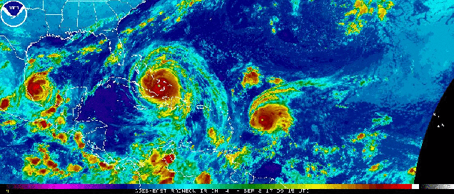
A tropical storm in the Gulf of Mexico blows up to a Category 4 hurricane and makes landfall, creating widespread damage along the Texas coast. Then, we stall the storm, have it sit there for days, and drop upwards of 4 feet of rain on Texas, resulting in some of the worst flooding ever seen. Just to make it worse, we’ll have the flooding centered around Houston, the 4th largest city in the nation. Then, after sitting there for a few days, we’ll have it go back into the Gulf of Mexico, strengthen a little, and head northward, making landfall again in Louisiana, dumping 1-3 feet of rain on that state and nearby parts of Texas that just barely missed out on the first batch. As that storm moves inland and finally dissipates, we’ll have another storm form way out in the Atlantic. That storm will grow into a beast – one of the strongest storms ever observed in the Atlantic. It head towards the islands in the Caribbean, and lay waste to a few of them, destroying pretty much everything in its path as it shatters records for strength and intensity. Then, after crossing the Bahamas, it’ll take aim at Florida, going on a near-worst-case scenario track for the entire state. It’ll make landfall in southern Florida as a Category 4 or 5 storm, and head due north, bringing hurricane conditions to pretty much the entire state, except maybe the Panhandle. Not only that, but we’ll have the worst conditions, the ones in the eyewall, pass right over heavily-populated Miami and Fort Lauderdale. While everyone is paying attention to the massive storm heading for Florida, we’ll have not one, but TWO more hurricanes develop, one in the Atlantic and another one in the Gulf. For the one in the Atlantic, we’ll have it blow up into a Category 4 storm, and then head right towards the same islands that just got wiped out 2 days earlier by the first storm. For the one in the Gulf, we’ll have it head towards Mexico. But wait, that’s not enough. While the folks in Mexico are preparing for a hurricane, we’ll have an 8.2 magnitude earthquake nearby, the strongest quake to impact Mexico in 100 years.

That’s the basic script, except it’s not a Hollywood creation, it’s the real thing. So, let’s get right to the details.

11L_tracks_latest
Computer model forecasts for the track of Irma. Image provided by Tropical Tidbits.


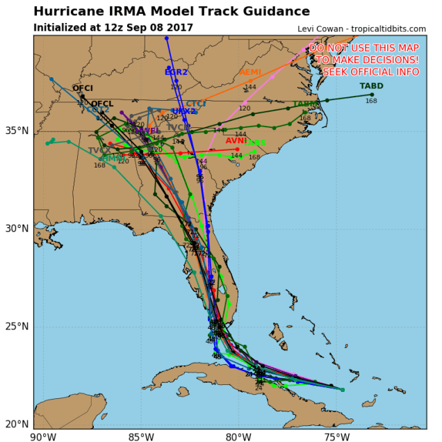
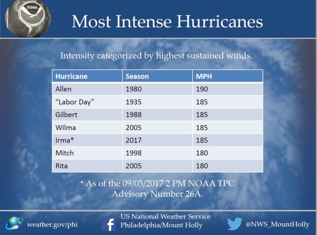
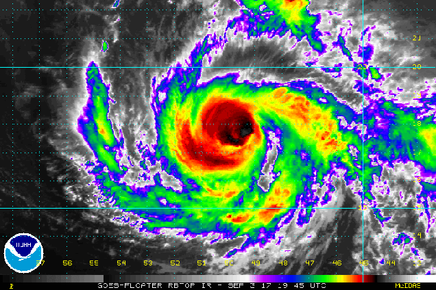
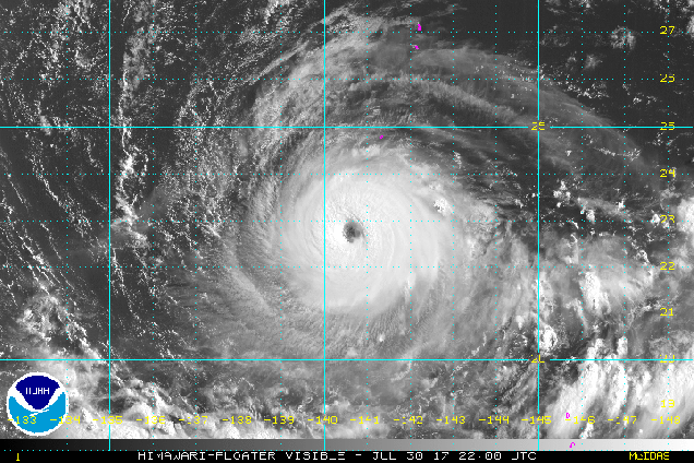
As of early Friday afternoon, Hurricane Irma was a Category 4 hurricane with maximum sustained winds near 155 mph. It was centered about 380 miles southeast of Miami, moving towards the west at 14 mph. Hurricane Warnings and Storm Surge Warnings are in effect for most of central and southern Florida, as well as the Bahamas and Cuba, with Hurricane Watches for much of northern Florida. Don’t let the fact that Irma has weakened to a Category 4 fool you. This is still a powerful storm, and its intensity will fluctuate for the next 24-36 hours. It could very easily regain Category 5 status, and will likely make landfall in Florida as a Category 4 or 5 storm.

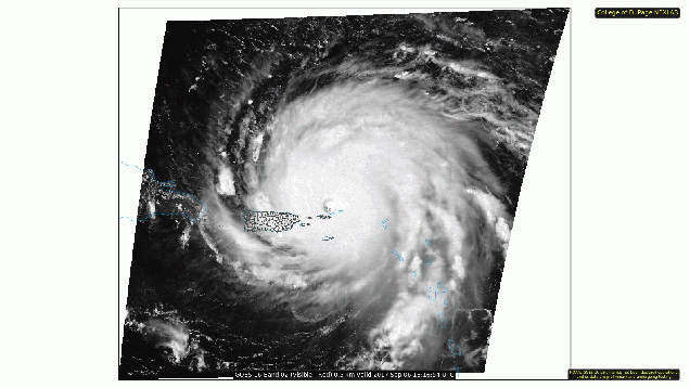
Irma will continue on a general west-northwest track today, as it moves around the southern edge of a ridge of high pressure. At some point in the next day or so, it’ll reach the southwestern edge of that ridge and make a sharp right turn. Exactly when that turn occurs is key to landfall. Right now, it looks it’ll move across the Upper or Middle Keys, and then make landfall in extreme southwestern Florida Sunday morning. The good news is that this is where the Everglades are, and very few people live there. The bad news is that since it’s mostly the Everglades, the storm surge may penetrate very far inland. That’s not the end of the bad news though. The current track brings the storm virtually due northward, which means that for Sunday into early Monday, the storm will head right up the middle of Florida. Yes it’ll be weakening, but should maintain hurricane strength until it gets close to the Florida/Georgia border. That means, hurricane conditions for much of the state, except possibly the Panhandle. Wait, it gets worse. The worst conditions will be in the eyewall, just to the right of the center. With the storm heading northward, that means east of the center. Where will that eyewall be Sunday morning? Right over downtown Miami and Fort Lauderdale. When Hurricane Andrew hit the region 25 years ago, it was a tiny storm. Even though it wiped out communities just south of Miami, downtown itself was largely spared, and Fort Lauderdale fared even better. That will not likely be the case this time, as Irma is considerably larger. Even places farther to the north, such as Orlando, may see wind gusts upwards of 90 mph. The theme park itself has been closed for a while now, but much of central Florida will get to experience “Wet n’ Wild” once again. While flooding won’t be on the scale of Harvey, rainfall totals of 8-16 inches and locally heavier are possible across Florida, which will lead to some flooding problems.

aal12_2017090812_track_early
Model forecasts for the track of Hurricane Jose. Image provided by the National Center for Atmospheric Research.

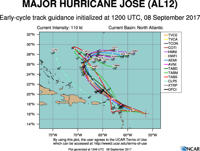
While all attention has been focused on Irma, Hurricane Jose has blown up into a Category 4 hurricane in the Atlantic. As of early Friday afternoon, Jose was centered a little more than 380 miles east-southeast of the Northern Leeward Islands, moving toward the west-northwest at 18 mph. Maximum sustained winds are near 150 mph, and some fluctuations in intensity are expected for the next day or two. Jose should continue towards the west-northwest for another day or so before turning more towards the northwest. Unfortunately, that track will bring Jose very close to the islands in the northern Leeward Islands. These are the same islands that Irma just devastated a couple of days ago. Hurricane Watches have been posted for many of these islands, with Tropical Storm Watches farther south and west. The Tropical Storm Watches do not indicate that weakening is expected. They just show that those islands should be far enough from the center that they will “only” receive tropical storm conditions, and not hurricane conditions. Once Jose gets past the islands, things get a little more murky. Jose should head into the open Atlantic and start to weaken, but it will also slow down, and perhaps stall as high pressure builds in to its north. By the middle of next week, there is plenty of disagreement among the models as to where Jose will go. Some models have the high pressure area retreating, which will allow Jose to head back into the open Atlantic. Others have the high pressure area strengthening, which would send Jose westward, towards the Bahamas and possibly the East Coast. It is WAY too early to figure out which solution is more plausible at this point. So, we may be dealing with Jose at some point again next week.

gfs_tprecip_gulf_17
GFS model forecast for rainfall across the Gulf of Mexico over the next 4 days. Irma will produce torrential rainfall across Florida, while the smaller Katia will bring heavy rain to parts of Mexico. Image provided by WeatherBell.


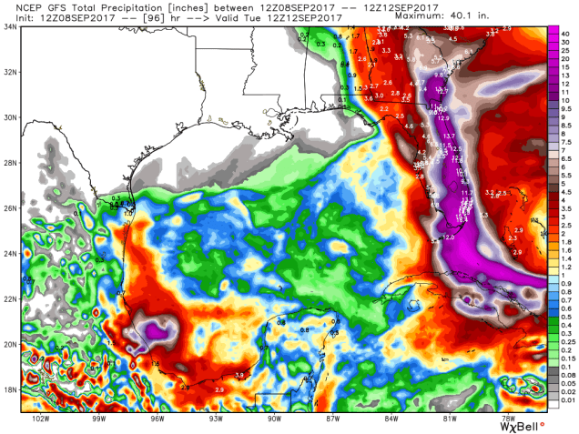
Wait, don’t stop reading now! We’ve got even more to talk about! In the Gulf of Mexico we have Hurricane Katia! As of midday Friday, Katia was centered about 125 miles north-northeast of Veracruz, Mexico, drifting toward the west-southwest at 5 mph. Katia is a Category 2 Hurricane, with top winds near 100 mph. Hurricane Warnings are in effect for parts of the Mexican coastline. Katia should make landfall tonight, then rapidly weaken once moving inland, as it encounters the mountainous terrain of Mexico. While this will keep wind damage confined to coastal areas, it makes the threat of flooding and mudslides even worse. Rainfall totals of 10-20 inches and locally heavier are likely in this area over the next few days.

Oh, and if that’s not enough, another tropical wave will emerge from the coast of Africa this weekend. Several computer models show the potential for that system to develop as it moves across the Atlantic next week. So, the suddenly active Hurricane Season of 2017 will likely roll on well into September.

Irma Slams Barbuda and the Virgin Islands, What Will Jose and Katia Do?

While Hurricane Irma is rightfully grabbing all the attention, there are two other tropical storms that could be threats to land in the coming days.

CODNEXLAB-GOES16-Visible-18-28Z-20170906_3473-3497-1-100
Visible satellite loop of Hurricane Irma early Wednesday afternoon. Loop provided by the College of DuPage.


After moving across Barbuda, St. Barts, and St. Martin overnight, the eye of Hurricane Irma was moving across the British Virgin Islands  Wednesday afternoon. When Irma moved across Barbuda last night it produced sustained winds of 118 mph with a gust to 155 mph, before the anemometer failed at an automated observing station. Sustained winds of 106 mph with a gust to 131 mph were reported at Buck Island in the US Virgin Islands this afternoon, while a wind gust to 113 mph was also reported in Estate Bovoni on St. Thomas in the US Virgin Islands. Irma should continue moving west-northwestward today and tonight, with the eye passing just north of St. John and St. Thomas in the US Virgin Islands. While this places these islands in the southern eyewall, believe it or not, things could actually be worse. The strongest winds in the storm have been observed in the northern eyewall, which will remain over open water. Maximum sustained winds in this part of the storm are estimated to be near 185 mph, making Irma one of the strongest storms ever in the Atlantic Basin. In fact, if you exclude the Gulf of Mexico and the Caribbean Sea. it is the highest winds in any hurricane in the Atlantic Ocean. Likewise, reconnaissance aircraft measured a pressure of 914 millibars in Irma’s center early Wednesday morning. Excluding the Gulf of Mexico and the Caribbean Sea again, this is the lowest pressure measured in a tropical system in the Atlantic Ocean. The old record was 915 millibars in Hurricane Isabel in 2003. The record low for the Atlantic Basin is 882 millibars set during Hurricane Wilma in 2005 in the northwestern Caribbean Sea.

TopCanes
The most intense hurricanes in the Atlantic Basin, ranked by maximum sustained winds. Image provided by the National Weather Service office in Mt. Holly, NJ.


Irma’s southern eyewall will likely move across northern Puerto Rico, possibly including the San Juan area. Hurricane strength winds were already moving into Culebra early Wednesday afternoon, with sustained winds to 73 mph and gusts as high as 96 mph reported. In addition to the wind, heavy rain is expected across the Virgin Islands and northern Puerto Rico. Rainfall totals of 5-10 inches with locally heavier amounts, will likely produce flooding in some areas. Lesser rainfall totals are expected across St. Croix as well as southern Puerto Rico.

Once Irma moves away from Puerto Rico, the obvious question becomes “Where will it go next?” Hurricane Warnings are in effect for the northern coast of the Dominican Republic and Haiti, as the storm will likely pass just north of those nations, but close enough to bring hurricane conditions to coastal locations. Hurricane Warnings are also in effect for the Southeastern Bahamas, as well as the Turks and Caicos Islands. Right now, Irma is expected to pass right across some of these islands as a Category 4 or 5 hurricane later Thursday into Friday. Beyond that, there is still a lot of uncertainty.

Hurricane Watches have been posted for eastern Cuba as well as the Central Bahamas. Irma could be impacting either location by later on Friday. For the past few days, many of the forecast models showed the potential for Irma to head west-northwestward, possibly impacting or even making landfall in northern Cuba before making a sharp right turn and heading towards southern Florida. However, since last night, many of these models have started to shift a bit, now showing that turn coming earlier, with Irma possibly making landfall in south Florida this weekend, or possibly turning even earlier, and heading northward towards the coast of Georgia or the Carolinas. Even places farther up the coast might not be out of the woods yet either. At this point, it’s still too early to tell which scenario will be more plausible. Anyone with interests from North Carolina to Florida and the Bahamas should pay very close attention to Irma, and be prepared to take action on short notice.

aal12_2017090612_track_early
Model forecasts for the track of Tropical Storm Jose. Could the Leeward Islands really get hit again a few days later? Image provided by the National Center for Atmospheric Research.

Meanwhile, Tropical Storm Jose is nearing hurricane strength in the Central Atlantic Ocean. As of midday Wednesday, Jose was centered about 1135 miles east of the Lesser Antilles, moving towards the west-northwest at 17 mph. Maximum sustained winds are near 70 mph, and Jose will likely strengthen into a hurricane later today. Jose is expected to turn more towards the northwest while strengthening over the next few days. While the storm is currently expected to pass north and east of the Leeward Islands, it wouldn’t take much of a shift in the track to bring the storm closer to areas that got hammered by Irma last night. That’s just what they need, right? Start the cleanup from one of the worst storms in history, then have another hurricane come by 4 days later? Look at the bright side – there wouldn’t be much left to damage.

gfs_tprecip_gulf_21
Rainfall forecast for the next 5 days from the GFS model. At least the heavy rainfall is staying out of Texas for the most part. Image provided by WeatherBell.

We also have Tropical Storm Katia in the southwestern Gulf of Mexico. At midday Wednesday, Katia was centered about 175 miles north of Veracruz, Mexico, drifting east-southeastward at 5 mph. Katia has maximum sustained winds near 45 mph, and additional strengthening is expected. Katia should start to drift more towards the south and southwest while strengthening over the next day or two. Katia could become a hurricane before making landfall in Mexico towards the end of the week. Katia may produce heavy rain across parts of Mexico, with rainfall totals of 10 to 20 inches possible leading to flooding and mudslides across the area.  Luckily, these rains will stay well south of the areas that Harvey flooded out a few weeks ago.

Weekly Outlook: September 4-10, 2017

rbtop_lalo-animated
Irma is already a powerful storm, and will likely get even stronger. Loop provided by NOAA.

Before we get to the week ahead, we’ll address Irma, since we’ve been getting questions about it already. As of 11pm Sunday, Irma was centered a little more than 700 miles east of the Leeward Islands with maximum sustained winds near 115 mph. It is moving towards the west-southwest at 14 mph. Hurricane Watches have been posted for the islands in the northeastern Caribbean. Irma will turn more towards the west and west-northwest over the next few days, with some fluctuations in intensity. It will pass very close to the islands of the northeastern Caribbean on Tuesday, then likely pass just north of Puerto Rico and the Virgin Islands, before setting its sights on the southeastern Bahamas later this week. Beyond that? Well, that’s a question that really can’t be answered yet. The computer models, which can be notoriously bad more than a couple of days out, are all over the place. Just based on these, landfall, could occur anywhere between New Orleans and Nova Scotia, or not at all. It will be a few more days at least before we start to have any clarity on whether the storm will impact the United States or not. If it were, it wouldn’t happen until early next week anyway. We’ll likely have a special post about Irma later this week, where we take a deeper dive into the storm. For now, just keep an eye on it, especially if you live near the coast.

11L_tracks_latest
Model forecasts for the track of Hurricane Irma over the next 5-7 days. As you can see, it’s likely still at least a week away from any potential impacts to the US. Image provided by Tropical Tidbits.

As for what will happen up here, we’ve got a spectacular Labor Day coming up. As we read the traditional end of summer, it will certainly feel likely summer today with sunshine and warm temperatures. Tuesday will likely end up as another warm day, but the sunshine will disappear early behind increasing clouds. The more sunshine that we get, the warmer it will be. A cold front will slowly approaches the region, and may end stall out across the area. As a result, we’re looking at an extended period of wet weather starting late Tuesday or Tuesday night, going right into Thursday or perhaps even much of Friday. It’s not going to be raining the entire time, in fact, there may be extended stretches of time where it’s not raining, but for the most part, it will be cloudy, cooler, and damp, with occasional rain and thunderstorms. Some of the rain will be heavy, which is actually good news, since parts of the region are starting to slip back towards drought conditions. Once this front finally moves out on Friday, high pressure builds in next weekend with sunshine and milder conditions.

20170829_northeast_trd
Latest updated on drought conditions across the Northeast. Image provided by the US Drought Monitor.


Labor Day: Sunshine and a few clouds. High 76-83.

Monday night: Mostly clear with some high clouds moving in late at night. Low 61-68.

Tuesday: Some early sunshine, then clouds thicken up. Showers and thunderstorms may develop late in the day, mainly north and west of Boston. Breezy. High 80-87.

Tuesday night: Showers gradually spread across the region. Low 62-69.

Wednesday: Cloudy with occasional showers and a few thunderstorms. High 70-77.

Thursday: Cloudy with more showers and drizzle expected. High 67-74.

Friday: More clouds than sun, some lingering showers, especially south of Boston. High 67-74.

Saturday: Plenty of sunshine. High 64-71.

Sunday: Mostly sunny. High 67-74.

Weekly Outlook: August 28-September 4, 2017

“Summer’s going fast, nights growing colder”


Neil Peart wrote that line (and the rest of the song) 30 years ago, but it’s appropriate right now, as we’re coming up on Labor Day weekend, the “traditional” end of summer. Of course, meteorological summer ends on Thursday, so, we really are getting closer to fall. Just for completeness, the autumnal equinox occurs at 4:02pm on September 22. Of course, we’ve had plenty of hot weather in September before, so don’t start putting away the shorts just yet.

image7
Rainfall totals across southeastern Texas through Sunday afternoon. Image provided by the National Weather Service Office in Houston.


Before we get to the forecast around here, we’d like to discuss Harvey a little. In our post a few days ago, we mentioned the possibility that some locations could see 30-40 inches of rain over the span of a week as Harvey stalled across the region. Well, it looks like we underestimated that. Much of the area, especially right around Houston, has already seen 15-30 inches of rain, leading to catastrophic flooding across the region. Some of the pictures of the flooding have been just incredible. Unfortunately, with Harvey expected to move very little over the next few days, another 15-30 inches may fall across the region.

wpc_total_precip_tx_28
Rainfall forecast for the next 7 days across Texas and the Lower Mississippi Valley. Image provided by WeatherBell.


As for around here, the week will start off dry and cool, which is how the last week ended. High pressure remains in control, which will give us some sunshine for one more day. High clouds will start to stream in on Tuesday ahead of a tropical system off the East Coast (more on that in a minute). That system will pass south and east of the region Tuesday night and Wednesday as it becomes a post-tropical system. It will likely pass close enough to spread some gusty winds and maybe some showers into Cape Cod and possible southeastern Massachusetts. A cold front then swings through the region on Thursday, bringing in more showers and maybe some thunderstorms. High pressure then returns will dry and cool conditions for Friday and Saturday. Clouds start to move back in on Sunday, and unfortunately, Labor Day isn’t looking that great right now, as a storm system moving in from the Great Lakes may bring us more showers. However, it’s a week away and things can change, so don’t go cancelling any plans just yet.

ndfd_t2min_massachusetts_1
We’ll start the week off with a cool Monday morning. These readings are 5-10 degrees below normal. Image provided by WeatherBell.


As we mentioned a moment ago, we may have a tropical system to deal with off the East Coast. As early early Monday morning, Potential Tropical Cyclone 10 was centered about 165 miles south-southwest of Charleston, South Carolina. The system doesn’t have a well-defined circulation yet, which is why it’s only a “potential” tropical cyclone. If it does get its act together, it will be named Irma. The current forecast is for that to happen while the storm starts moving northeastward. Since it will likely bring gusty winds and heavy rain to parts of the Carolinas, a Tropical Storm Watch has been issued from the South Santee River in South Carolina northward to Duck, North Carolina, including the Pamlico and Albemarle Sounds. Once it passes the Outer Banks of North Carolina, it will likely accelerate east-northeastward out into the open Atlantic while slowly strengthening, but also losing its tropical characteristics.

aal10_2017082800_track_early
Computer model forecasts for the track of Potential Tropical Cyclone 10. Image provided by the National Center for Atmospheric Research.


Monday: Sunshine and some afternoon clouds. High 70-77.

Monday night: Some high clouds may start to spread across the region. Low 52-59.

Tuesday: Sunshine filtered through high clouds to start, but clouds start to thicken up during the afternoon. High 66-73.

Tuesday night: Mostly cloudy, becoming breezy across Cape Cod. Some showers are possible, mainly across Cape Cod and southeastern Massachusetts. Low 53-60.

Wednesday: Some showers possible in the morning across Cape Cod and southeastern Massachusetts, then skies clear out in the afternoon. High 66-73.

Thursday: A sunny start, then clouding back up with showers and maybe some thunderstorms late in the day. High 77-84.

Friday: Sunshine and a few clouds. High 65-72.

Saturday: Partly to mostly sunny. High 69-76.

Sunday: Intervals of clouds and sunshine. High 76-83.

Labor Day: Mostly cloudy and breezy with a chance of showers. High 78-85.

Longer range: Aside from a system bringing in some showers towards midweek, much of next week looks dry and cool.

Houston Might Have a Problem Named Harvey

A week ago, Tropical Storm Harvey produced wind gusts as high as 44 mph in the Windward Islands. It moved into the eastern Caribbean and fell apart a few days later, degenerating into a tropical wave. Four days after that,  Harvey has regenerated into a tropical storm over the Bay of Campeche. Now, it’s setting it sights on Texas.

2e04ddba-46fb-433e-8c59-8d123dd75697_image
Sorry, wrong Harvey. This Harvey isn’t a problem at all. Image provided by WCVB.

As of early Thursday morning, Tropical Storm Harvey was centered about 410 miles southeast of Port Mansfield, Texas with maximum sustained winds near 45 mph. Harvey was moving toward the northwest at 7 mph. A hurricane watch is in effect for the coast of Texas from Port Mansfield, to San Luis Pass. Tropical Storm Watches have also been issued from Port Mansfield southward to Boca de Catan, Mexico, and from San Luis Pass northward to High Island, Texas. A Storm Surge Watch is also in effect from Port Mansfield to High Island.

09L_tracks_latest
Harvey certainly looks to be heading towards the Texas coastline. Once it gets there, where it goes is a question that really can’t be answered yet. Image provided by Tropical Tidbits.

Current indications are that Harvey should continue to head northwestward while strengthening over the next day or two. Harvey should be approaching the Lower or Middle Texas coast on Friday. With warm water and low wind shear, there is a chance that Harvey could rapidly intensify on Thursday, and should become a hurricane before landfall, possibly a strong hurricane.

Two-Face_0002
This Harvey is a problem for Gotham City, not Houston. Image provided by DC Comics Database.

Once Harvey makes landfall, it will start to slow down and its movement could become erratic as there will be little in the way of upper-level wind flow to steer the storm. Many models are now showing a turn towards the west or southwest for a day or two, others show the storm nearly stationary once inland, and still others have the storm drift off towards the east or northeast after landfall. There’s also the chance that Harvey stalls before moving inland. The exact track that Harvey takes will have a huge impact on the region for obvious reasons.

While wind and storm surge are obviously threats to Texas, especially along the coast near where Harvey makes landfall, by far, the bigger threat at this point is flooding from heavy rainfall. The slow movement once inland means that heavy rain will continue across portions of the region for several days, leading to widespread, severe flooding, especially across parts of south and southeast Texas.

qpf_acc.us_sc (1)
GFS model forecast for rainfall across Texas for the 7 days ending Wednesday August 30. That’s a LOT of water. Image provided by Pivotal Weather.

Some models, such as the one above, are showing the possibility for 10-20 or more inches of rain across parts of the area over the next week. Some models are showing extreme totals of 30-40 or more inches during the same time frame. While these numbers seem unbelievable, they wouldn’t be unprecedented. Hurricanes that move out of the Gulf of Mexico are usually loaded with tropical moisture and if they are moving slow enough, can produce several months worth of rainfall in a matter of days. In 1978, Tropical Storm Amelia dropped 48 inches of rain on Medina, Texas. This is the most rainfall recorded from a single storm anywhere in the United States. Just one year later, Tropical Storm Claudette made landfall near the Texas/Louisiana border. In Alvin, Texas, just west of Houston, a total of 42 inches of rain was recorded in just 24 hours. This set a new record for 24-hour rainfall in the contiguous United States. More recently, in 2001, Tropical Storm Allison produced 20-40 inches of rain on portions of southeastern Texas and Louisiana.

nam_total_precip_florida_29
NAM model forecast for rainfall across Florida through Sunday morning. Some flooding seems like a possibility south of I-4. Image provided by WeatherBell.

Meanwhile, a trough of low pressure is drifting across Florida this morning. This system will produce heavy rain across portions of the Sunshine State over the next few days, which could lead to some localized flooding. Once it drifts back into the Atlantic, it will need to be watched for signs of development. While the most likely track for the system, if it develops at all, is to head northeastward out into the open Atlantic, there are some models that show the potential for the system to impact portions of the East Coast early this weekend or next week, as we mentioned at the end of our Weekly Outlook on Sunday. We’ll continue to keep an eye on this system, just in case it does become a threat.

aal92_2017082400_eps_track_by_model_late
An out-to-sea track still looks most likely, but the potential for trouble along the East Coast still exists. Image provided by the National Center for Atmospheric Research.

Weekly Outlook: August 21-27, 2016

As we start a new week all eyes will literally be looking at the sky. As you may have heard, there’s an eclipse today. The weather will cooperate, as high pressure provides us with sunshine, so viewing it shouldn’t be a problem. You’ve probably also heard plenty of people warning you not to look directly at the sun during the eclipse. Since you’ve heard it enough already, we won’t say it. Besides, if you want to look at the sun, we won’t stop you. Eyesight is overrated anyways. Plenty of people live without it. If that’s what you want, who are we to stop you? You’ll still be alive and free to go golfing in the middle of the thunderstorms we’re expecting on Tuesday. Don’t worry, they’ll likely be coming at night, so even if you were golfing, you wouldn’t be able to find the ball if you had eyesight.

hrrr_cloud_boston_16
Cloud cover forecast from the HRRR model for 2pm Monday. Just a few clouds around, which shouldn’t impact eclipse viewing much. Image provided by WeatherBell.


Now that we’ve given you the teaser and the sarcasm, let’s get to the details. We start the week off with high pressure, giving us a fantastic Monday. A cold front approaches on Tuesday, producing showers and thunderstorms, mainly at night. A few of these storms could be quite strong, but with the activity mostly expected at night, that should limit the potential for severe weather. Of course, that doesn’t mean you should let your guard down. These storms still could produce heavy downpours, but severe weather is still possible at night. In fact, Tuesday marks the one year anniversary of the tornado that impacted Concord, MA at 3:20 in the morning.

14107865_1077824382311932_2028629579549064186_o
A rare overnight tornado impacted Concord, MA one year ago tomorrow. Image provided by the National Weather Service office in Taunton, MA.

The showers and thunderstorms will taper off and end early Wednesday as a cold front crosses the region, then things get quiet again. We’ll dry out Wednesday afternoon but it will remain warm. We’ll cool off a little more on Thursday as an upper-level trough of low pressure settles into the Northeast while high pressure does at the surface, which will result in some cool days for Friday and the weekend.

Monday: Sunshine and a few afternoon clouds, dimmed for a while by a passing moon in the afternoon. High 82-89.

Monday night: High clouds overspread the region. Low 64-71.

Tuesday: Clouds thicken up, with some showers and thunderstorms possible late in the day. High 85-92.

Tuesday night: Showers and thunderstorms likely, some of which could contain heavy downpours and gusty winds. Low 68-75.

Wednesday: Showers and thunderstorms end in the morning, then skies clear out in the afternoon. High 78-85.

Thursday: Sunshine and some afternoon clouds. High 74-81.

Friday: A sunny start, then clouds start to pop up with a slight chance for a spot shower in the afternoon. High 71-78.

Saturday: A mix of sunshine and clouds. High 70-77.

Sunday: Partly to mostly sunny. High 70-77.

Finally, we get to a topic that doesn’t impact this week’s forecast, but could have an impact early next week. For several days now, the Canadian model has been extremely insistent on a tropical disturbance developing near the Bahamas and eventually moving northward, up the East Coast early next week. There have been a few reasons to ignore this for the past few days:

  1. This was the only model showing this feature.
  2. The Canadian model always seems to take every little ripple in the tropics and blow it up into a hurricane.

So, why are we mentioning it now? There are a few reasons.

  1. Other models are starting to show the potential for something to develop near the Bahamas or Florida late this week or early next week.
  2. The Canadian model has been slightly better than many of the other models in regards to the tropics so far this season.
  3. It’s had this feature with very little variation for at least 6 consecutive model runs.

That last point is the main reason why we at least feel the need to mention it. This model has not really wavered much at all, and consistency is one of the things we look for in a model before we start to trust its solution. Add in the fact that other models are starting to come around, and well, it’s something we need to keep an eye on. This does not mean that a massive hurricane is going to wipe out the East Coast just before Labor Day. If anything does materialize, we’ll obviously keep you informed, but for now, it’s just something to keep in the back of your mind. (Of course, now that we’ve mentioned it, the next run of the Canadian model will likely change its tune completely)

gem_mslp_wind_92L_fh0-240
Forecast for Atlantic Disturbance 92L based on the Canadian GEM model initialized Sunday evening. Loop provided by Tropical Tidbits.

Weekly Outlook: August 14-20, 2017

We’ve actually got a fairly straightforward forecast for much of this week, so we’ll get right to it.

The week starts off with high pressure bringing us sunshine and seasonable temperatures for Monday. A cold front moves through on Tuesday, with some showers and thunderstorms expected. A few of them could be on the strong side, but the bulk of the activity will remain to the north and west of most of the people reading this. Drier weather returns behind the front on Wednesday. Clouds return on Thursday ahead of another system. This is where we get to our question mark of the week – when will it rain?

Some models have the rain come in for Thursday night and Friday, others for Friday into Friday night. The timing of the rain and the cold front will also have implications on the temperatures, especially on Friday. These questions really can’t be answered yet. Things start to improve on Saturday, though another shower can’t be ruled out. High pressure then returns for Sunday.

ww3_height_dir_nwatl_23
Some pretty big waves are possible along south-facing beaches by Wednesday as Tropical Storm Gert passes well offshore. Image provided by WeatherBell.

Turning our attention to the tropics, we have Tropical Storm Gert, which is in between the East Coast and Bermuda. Unless you are a boater or are planning a cruise to Bermuda this week, you have nothing to worry about. Gert will strengthen some more, possibly even becoming a hurricane in a day or two. It will head northward, then make a sharp right turn and head out into the open Atlantic without threatening any land areas.

08L_tracks_latest
Model forecast for the track of Tropical Storm Gert. Image provided by Tropical Tidbits.

Perhaps you’ve heard rumblings of another system in the Atlantic? Yes, there is a wave that came off of Africa recently, and will be monitored as it makes it’s journey westward. Yes, it’s true that some of the models show it strengthening and possibly even threatening the East Coast. Here’s the thing, and we have mentioned this before. The models suck at predicting these things until they actually form. Even then, they’re not that much better. For example, the GFS model, which is the one that most people look at because it goes out 16 days had the storm that eventually became Gert. As we mentioned earlier, Gert is about halfway between the East Coast and Bermuda, and has a central pressure of 1009mb. If you go back and look at the GFS forecast from 11 days ago, it had Gert this evening centered about 50 miles east of Vero Beach, FL as a Category 5 hurricane with a central pressure of 926 mb. If this were the winter, that’d be the equivalent of a forecast of 4 feet of snow and you actually get sunshine. (We don’t want to hear any snide remarks – our forecasts has never been that bad) We’ll step off of our soapbox now, but please keep in mind, unless there’s actually a storm out there, ignore what the computers and especially the Facebook Forecasters have to say.

Monday: Sunshine and some high clouds. High 79-86.

Monday night: Becoming partly to mostly cloudy. Low 61-68.

Tuesday: Mostly cloudy with a chance of showers and thunderstorms. High 79-86.

Tuesday night: Clearing skies. Low 60-67.

Wednesday: Sunshine and a few clouds. High 80-87.

Thursday: Clouds slowly thicken up throughout the day. High 77-84.

Friday: Cloudy with showers likely. High 72-79.

Saturday: Intervals of clouds and sun, another shower or two possible. High 76-83.

Sunday: Partly to mostly sunny. High 74-81.

Weekly Outlook: July 31 – August 6, 2017

Let’s turn the clock back about 6 months, to February 9, 2017. Do you remember that day? Patrice Bergeron had 4 points and the Bruins beat San Jose 6-3 in Bruce Cassidy’s first game as the new Bruins head coach. The Celtics beat the Portland Trailblazers 120-111, led by Isaiah Thomas scoring 34 points. Of course, we were also just four days removed from the greatest comeback in Super Bowl history. Do you remember anything else about that day? No? Nothing? Let us refresh your memory:

Feb_09_2017_Snow_Anal_exp
Snowfall totals from February 9,2017. Image provided by the National Weather Service Office in Taunton, MA


Yeah, you remember now, don’t you? You were trying to block it out and we just brought it back. It was in the 20s and lower 30s for temperatures, and snowed heavily for much of the day. As you can see from the map above, many of us were shoveling somewhere in the vicinity of a foot of snow that day. So, why are we bringing this up now? We’re betting that on that day, you were probably thinking about a nice week of vacation in the middle of the summer, with sunshine, warm temperatures, and no hint of any snow. Does this sound familiar? Well, that week you were dreaming of is here.

High pressure will be in control for much of the week. For the first half of the week, that means sunshine, warm temperatures, and low humidity. Temperatures and humidity levels will start to creep up as we head towards midweek, with the possibility of some afternoon showers and thunderstorms as we get later in the week. A cold front may bring in more showers and thunderstorms on Saturday, then high pressure returns for Sunday.

nam_dew2m_boston_7
Dewpoints in the upper 50s to lower 60s on the last day of July? We’ll take that without question. Image provided by WeatherBell.


Monday: Wall-to-wall sunshine with just a few afternoon clouds. High 81-88, a little cooler along the coast.

Monday night: Mostly clear. Low 59-66.

Tuesday: Partly to mostly sunny. High 83-90. a little cooler right along the coast.

Tuesday night: Clear to partly cloudy. Low 63-70.

Wednesday: A mix of sun and clouds, more humid, a shower or thunderstorm can’t be ruled out. High 83-90.

Thursday: Partly sunny, afternoon showers or thunderstorms are possible. High 83-90.

Friday: Sunshine and some afternoon clouds, breezy, slight chance for a shower or thunderstorm. High 81-88.

Saturday: More clouds than sunshine with scattered showers and thunderstorms. High 77-84.

Sunday: Partly to mostly sunny. High 77-84.

Finally, we’ll mention a couple of things about the tropics. There are still a few storms in the Pacific, and one area we’re watching in the Gulf of Mexico. First, we’ll talk about the Gulf, since it’s closer. There’s a cluster of thunderstorms off the west coast of Florida. It’s got a small window of opportunity to get its act together before moving into Florida on Tuesday. Once it moves back into the Atlantic, it could strengthen on its way out to sea. It’ll bring some heavy rain to Florida and the Bahamas over the next few days, but otherwise, it doesn’t look like a big deal.

98L_tracks_latest
Computer model forecasts for the track of a tropical disturbance in the Gulf of Mexico. Image provided by Tropical Tidbits.

In the Pacific,  things aren’t nearly as active as they were earlier in the week. We still have Tropical Storm Irwin in the Eastern Pacific, but probably not for too much longer. In the Western Pacific, we have Super Typhoon Noru. Noru is impacting a few small islands well south of Japan, and has likely peaked in intensity with maximum sustained winds near 150 mph early Monday morning. There’s still plenty of uncertainty in regards to Noru’s future track, and it could threaten southern Japan later this week. For now, just take a look at this beautiful monster:

vis_lalo-animated
Visible satellite loop of Super Typhoon Noru. She’s a beauty, eh? Loop provided by NOAA.

The Atlantic Remains Quiet While the Pacific is Quite Active


The tropics remain quiet in the Atlantic right now, but it’s a different story in the Pacific, where there are currently six active systems, three in the East, and three in the West. This doesn’t even count the remains of a system crossing Hawaii today and another area being watched for development in the Western Pacific.

Starting with the Eastern Pacific, Hurricane Hilary is the strongest on the storms as well as the closest to land. At midday Monday, Hillary was centered about 340 miles south of Manzanillo, Mexico, moving towards the west-northwest at 8pm. This track is expected to continue for the next few days, bringing the system away from Mexico. Hilary has maximum sustained winds near 80 mph, but it is in an environment favorable for strengthening, and is expected to become a major hurricane over the next 24-36 hours. After that, a gradual weakening trend is expected.

EP092017_5day_cone_no_line
Forecast track for Hurricane Hilary. Image provided by the National Hurricane Center.


A little farther to the west is Tropical Storm Irwin. Irwin was centered about 750 miles southwest of Cabo San Lucas, Mexico at midday Monday, drifting westward at 3 mph. Irwin has maximum sustained winds of 60 mph, and additional strengthening is expected. Irwin should become a hurricane Monday night or Tuesday. The forecast track for Irwin is highly uncertain at the moment. Several of the computer models show an erratic motion for the storm, as it may interact with Hurricane Hilary. Whether or not it actually does interact with Hilary will have a large effect on its eventual track. Whether it does interact with Hilary or not, Irwin will remain over open water for the next several days, and is not a threat to any land areas.

10E_tracks_latest
Model forecasts for the track of Tropical Storm Irwin. There is plenty of disagreement among the models on its eventual track. Image provided by Tropical Tidbits.


Heading westward again, we come to Tropical Storm Greg. Greg’s top winds peaked at 60 mph on Friday, and it has been slowly weakening over the weekend. At midday Monday, Greg had top winds near 45 mph, and additional weakening is expected over the next few days. Greg was centered a little more than 1500 miles east of Hawaii, and was moving towards the west at 12 mph. Greg should dissipate well east of Hawaii later this week.

rbtop_lalo-animated
Tropical Storm Greg continues to gradually weaken over open waters. Loop provided by NOAA.


In the Central Pacific, there are no active storms at the moment. However, what’s left of Hurricane Fernanda is moving across Hawaii today, producing some gusty winds along with locally heavy showers and thunderstorms on Oahu and Kauai. At one point last week, Fernanda was a Category 4 hurricane with top winds of 145 mph over the open waters of the Eastern Pacific.

In the Western Pacific, we also have three active systems, and another area being watched for development.

abpwsair (1)
Satellite photo showing three active systems and another potential tropical system in the Western Pacific. Image provided by the Joint Typhoon Warning Center.


The strongest of the storms is Typhoon Noru (07W). Noru has been meandering around in the waters well southeast of Japan for several days, and this erratic motion should continue for another day or so before a general westward motion takes over. Noru currently has maximum sustained winds near 90 mph, and some further strengthening is possible over the next 36 hours. Noru will impact the Bonin Islands over the next few days with heavy rain and gusty winds. The GFS model shows the possibility that by next weekend, Noru could become a powerful typhoon in the waters south of Japan

1705-00
Forecast track for Typhoon Noru. Image provided by the Japan Meteorological Agency.


To the east of Noru is Tropical Storm Kulap (09W). Kulap is gradually weakening, and this should continue over the next few days. Kulap currently has top winds near 50 mph, but should weaken to a tropical depression by Tuesday. Kulap should continue moving off to the east, heading into the open waters of the Western Pacific, without impacting any additional land areas.

wp0917
Forecast track for Tropical Storm Kulap. Image provided by the Joint Typhoon Warning Center.


The storm that is the biggest threat to populated areas at the moment is Tropical Storm Sonca (08W). Sonca is currently centered about 160 miles east-northeast of Da Nang, Vietnam, driftng towards the southwest at 4 mph. A turn more toward the west is expected over the next 24 hours, with landfall in Vietnam expected by early Tuesday. Sonca has maximum sustained winds near 45 mph, and some additional strengthening is possible before landfall. The biggest threat from Sonca is flooding from heavy rains. Sonca could produce rainfall totals of 10-20 inches or more in parts of Vietnam and Laos.

2017072415z
Forecast track for Tropical Storm Sonca. Image provided by the Vietnam National Centre for Hydro-Meteorological Forecasting.


In addition to all the active systems, an area of disturbed weather about 375 miles northwest of Palau in the Western Pacific Ocean is being monitored for development. Conditions should be favorable for the system to develop over the next few days, and it could become a tropical depression later this week as it moves northward. Current computer model forecasts show the possibility of additional strengthening later this week, with the potential for a threat to the Philippines or Taiwan towards the end of the week.

99W_gefs_latest
GFS Ensemble forecast for the track and strength of a tropical disturbance in the Western Pacific Ocean. Image provided by Tropical Tidbits.


Computer model forecasts show that the active pattern will likely continue, especially in the Western Pacific, for the next few weeks at a minimum, with several more tropical cyclones possible. This is not a surprise, as the Western Pacific usually is the most active tropical cyclone basin in the world. So far in 2017, that hasn’t been the case. Although the number of storms has been close to normal in the Western Pacific (and the Atlantic), many have been weak and short-lived. Using a metric called Accumulated Cyclone Energy (ACE), which takes into account how strong a storm is, and how long it lasts, we see that so far this year, activity is below normal across the Western Pacific (and the Atlantic), and above normal in the Eastern Pacific.

Weekly Outlook: July 3-9, 2017

HoustonKansasCity 138
We’ll have perfect weather for fireworks displays on the Fourth of July.

We’ve made it to July, and the stubborn pattern we had for much of the Spring and well into June is finally gone.

We’ll start right off with the forecast for Tuesday, since that’s the day people are most interested in. Planning a barbecue? Perfect weather for it. Heading into the pool or to the beach? Bring the sunscreen. Watching fireworks in the evening? No problems expected. Stuck working because your chosen profession doesn’t take holidays? Sucks to be you, but don’t expect anyone to feel bad for you.

As for the rest of the week, sunshine and warm temperatures will be here for the next few days, along with low humidity, as high pressure builds in across northern New England. There is a slight chance for a shower or thunderstorm this afternoon as a weak upper-level disturbance moves through, mainly along the South Coast. However, the bulk of the activity looks like it should remain well to our south and west. As the high slides offshore later this week, humidity will start to creep back into the region. With humidity comes the risk for afternoon showers and thunderstorms. That risk looks to be the greatest Friday and Saturday as another cold front starts to approach the region. While it’s still a bit early, and the timing of the front will play a critical role, we wouldn’t be surprised to see some severe storms develop on Saturday, if everything comes together. We’ll monitor this as the week progresses. High pressure will build in behind the front with drier conditions for next Sunday.

GFSNE_con_sbcape_141
A moist and unstable airmass may be in place ahead of a cold front next Saturday, which could help to produce strong to severe thunderstorms. Image provided by the College of Dupage.
GFSNE_sfc_dewp_141
A moist and unstable airmass may be in place ahead of a cold front next Saturday, which could help to produce strong to severe thunderstorms. Image provided by the College of Dupage.

While we’ve got a fairly simple forecast here for most of the week, things are starting to cook out in the Atlantic. A tropical disturbance located well east of the Lesser Antilles has the potential to develop into a tropical depression later this week.  There’s nothing to worry about now, but some of the models (not all), try to develop the system into a hurricane at some point, and possibly become a threat to the East Coast or Bermuda about 2 weeks from now. The odds of this happening are still pretty low, so we wouldn’t worry about it too much, but we’ll certainly keep our eyes on this system, as well as the rest of the tropics.

94L_gefs_latest
GFS Ensemble forecasts for the track of a tropical disturbance in the Central Atlantic. Image provided by Tropical Tidbits.


Monday: A mix of sun and clouds, just a slight chance for an afternoon shower or thunderstorm near the South Coast. High 81-88.

Monday night: Clear to partly cloudy. Low 58-65.

Tuesday: Sunshine and a few clouds. High 77-84.

Tuesday night: Clear skies. Perfect weather for fireworks in the evening. Low 55-62.

Wednesday: Mostly sunny. High 78-85.

Thursday: A sunny start, then clouds develop along with the chance for some afternoon showers and thunderstorms, becoming humid. High 77-84.

Friday: A mix of sun and clouds, humid, chance for some afternoon showers and thunderstorms. High 80-87.

Saturday: Partly sunny, more showers and thunderstorms are possible. Some of the storms could be strong to severe in the afternoon. High 83-90.

Sunday: Mostly sunny with a few afternoon clouds, drier. High 75-82.