A rather active pattern is expected to continue for this week, with some snow for parts of the region, possibly more than once.
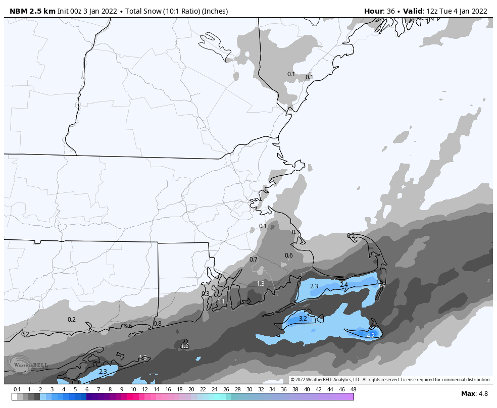
The week starts off with low pressure passing south of the region today. It will be close enough to spread some light snow into the Cape and Islands, and possibly southeastern Massachusetts. Any accumulations will be confined to the Cape and Islands, with Nantucket and Martha’s Vineyard possibly seeing a few inches. For the rest of us, it’ll be a cloudy and chilly day. Many places won’t get out of the 20s, and wind chills will be in the teens, so keep that in mind if you’ll be outside for any length of time today. We’ll clear out tonight as the system pulls away, then high pressure builds in with sunshine and seasonably cool conditions on Tuesday. We’ll start to warm up again on Wednesday, but also will have plenty of clouds and some showers ahead of another cold front. That front moves through early on Thursday, bringing an end to the showers, and ushering cooler air back in. After that, things get very uncertain.
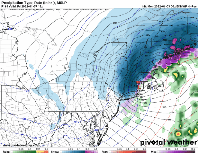
Some of the models have been hinting at the potential for coastal storm in the Thursday night/Friday time frame for quite some time now. However, since the models have downright awful beyond about 2-3 days, we haven’t bothered to look at the details too much, but have noted the potential. Well, it’s 5 days away now, and there is still plenty of disagreement as to what could happen, or if there will even be a system to affect the region. We’re of the belief that there will be a system, and it could produce some snow across at least inland locations. Beyond that, we’re not prepared to go into much more detail yet (though some of the usual internet trolls will probably be more than happy to find maps from models that show heavy snow and will share them all over Facebook and Twitter). Obviously, we’ll have a better idea as we get towards mid-week, and will elaborate more at that point, if needed.
High pressure builds in for Saturday with dry and chilly conditions, then another system could bring in some snow or rain showers for Sunday.
Monday: Plenty of clouds, snow showers likely across the Cape and Islands. High 25-32.
Monday night: Clearing and cold. Low 11-18.
Tuesday: Mostly sunny. High 29-36.
Tuesday night: Increasing clouds. Low 20-27.
Wednesday: Mostly cloudy, breezy, mild, chance for showers. High 45-52.
Thursday: Partly sunny. High 35-42.
Friday: Cloudy and breezy with a chance of snow or rain. High 32-39.
Saturday: Mostly sunny. High 26-33.
Sunday: Mostly cloudy with some snow or rain showers possible. High 37-44.
