As we get into the middle of August, we are at the traditional end of the so-called “Dog Days of Summer“. Most of this week is not going to live up to that name though. Instead, we’re going to be stuck with “MOTS” as the late, great Dick Albert used to say. That stands for “More Of The Same”. In other words, not much heat, but more rain.
The week starts off with low pressure passing south of New England. That means were in for some rain and cool conditions later Monday into Tuesday. In some places, it might be more than “some” rain, and could be “a lot” of rain. High pressure then builds in for Wednesday, Thursday, and possibly Friday, meaning we get to use another one of Dickie’s favorite expressions to describe those days – “F and D”, which means “Fine and Dandy.” Next weekend could be unsettled, as we’ll have a frontal system in the neighborhood, so the possibility for showers and thunderstorms will increase.

Monday: Cloudy with rain developing during the afternoon. High 72-79.
Monday night: Periods of rain and showers, possibly heavy at times, especially along the South Coast. A rumble of thunder is also possible. Breezy at times, mainly south of Boston. Low 58-65.
Tuesday: Showers taper off and end in the morning. Some sunny breaks may develop late in the day. High 70-77.
Tuesday night: Becoming mostly clear. Low 55-62.
Wednesday: Sunshine and a few afternoon clouds. High 77-84.
Thursday: Partly to mostly sunny. High 79-86.
Friday: A mix of sun and clouds. High 76-83.
Saturday: Partly sunny, chance for a few showers and thunderstorms. High 75-82.
Sunday: Intervals of clouds and sun with a chance for showers and thunderstorms. High 74-81.

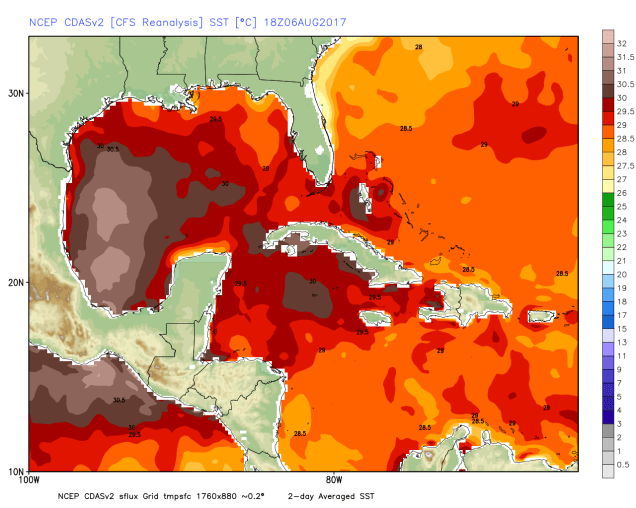
The tropical Atlantic is finally waking up from its long slumber. Tropical Storm Franklin formed late Sunday evening in the western Caribbean. As of early Monday morning, it was centered just off the coastline of Nicaragua and Honduras. Maximum sustained winds were near 45 mph. The current forecast calls for the storm to move into the Yucatan Peninsula Monday evening, then move back into the Gulf of Mexico on Tuesday. From there, it will likely head westward, towards the eastern coast of Mexico. Landfall is likely towards the middle to latter half of the week. The majority of the forecast models are showing that Franklin should make its second landfall as a strong tropical storm. We’re not so sure about that. For one, the models that predict intensity of tropical systems are, shall we say, not that good. OK, they suck. Maybe not as much as the New York Jets or the UMass Hockey team, but they’re not that good. Also, the water in the western Gulf of Mexico is some of the warmest water you’ll find in the Western Hemisphere right now. That could provide plenty of fuel to strengthen a system. There are plenty of other factors involved, starting with the potential for the system to not even survive its trip across the Yucatan. Having said that, we wouldn’t be surprised at all if Franklin approached the coast of Mexico as a Category 1 or 2 hurricane later this week.