Can you believe that 2017 is already 1/3 over? We’ve flipped the calendar over the May, so things should really start to improve now, right? Well, maybe. We’ll explain.
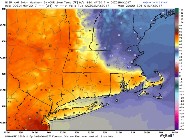
The week actually starts off with a rather tricky forecast as a warm front will try to move northward across the region. Notice that we said that it will “try” to move northward. We’re not sure how successful it will be. Some models bring the warm front right through the region, which will allow temperatures to soar into the 60s and 70s again today. On the flip side, some other models have the front get hung up across the region, with 60s and lower 70s south of it, but north of it, temperatures stay in the 50s, maybe even upper 40s. So, that is the big question for today. We’re leaning towards the latter scenario, with places north of Boston staying cool today, especially along the coast, though temperatures could rise in the evening and especially overnight as the warm front does eventually move through.

By tonight, some showers are expected ahead of a cold front, which will cross the region early Tuesday. Behind it, with developing sunshine, everybody warms up on Tuesday. (Yes, it will get warmer behind a cold front). High pressure builds in for Wednesday with cooler and drier conditions, then we start to warm up on Thursday as the high moves offshore. This bring us to the next problem.
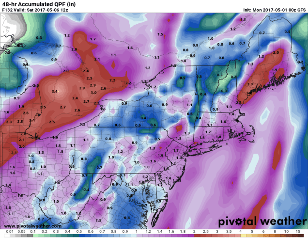
The forecast for the end of the week and the weekend is also pretty tricky. A slow-moving low pressure system will start to make its way towards New England later on Thursday. Some showers may develop Thursday night, but Friday is looking rather wet. In fact, we may be looking at some tropical downpours, as southerly winds bring moisture right up from the Gulf of Mexico ahead of this system. Of course, this is still 5 days away, so things can change. Maybe the setup won’t be just right, and we end up with showers and not downpours. Maybe the system slows down a bit and delays everything by 12 or 24 hours. There is still plenty of disagreement among the models to try to nail down the details. In other words, don’t cancel any outdoor plans for Friday just yet. That brings us to the weekend. Models are showing an upper-level system capturing the storm and taking its time to slowly move across the region. This would likely mean that Saturday and possibly Sunday could feature intervals of sun and clouds, with pop-up showers possible at almost any time. Again, don’t go cancelling any outdoor plans, but have a backup ready, just in case.
Monday: Plenty of clouds with a few sunny breaks possible, especially south of Boston. Chance for some drizzle or a few showers. High 48-54 along the NH Seacoast and in southern Maine, 56-63 for interior southern NH and northeastern Massachusetts, coolest along the coast, 64-71 south of Boston.
Monday night: Cloudy and breezy with showers likely. Temperatures hold steady or slowly rise overnight.
Tuesday: A few lingering showers early, then becoming partly sunny and breezy. High 68-75.
Tuesday night: Clear to partly cloudy. Low 43-50.
Wednesday: A mix of sun and clouds, slight chance for a shower. High 57-64.
Thursday: Sunshine fades behind increasing clouds. Showers develop at night. High 61-68, except a little cooler right along the coast.
Friday: Windy with periods of rain, possibly heavy at times. High 55-62.
Saturday: A mix of sun and clouds, breezy, chance for a few showers. High 58-65.
Sunday: Partly sunny, chance for more showers. High 55-62.
