Once again, we’ve got good news and bad news for the week ahead. The bad news is that the middle of the week will feature one, possibly two, absolutely miserable days. The good news? The end of the week will feature some fantastic weather. That makes us think of a certain move theme.
The week starts off with high pressure in control, giving us a fairly nice Monday, but things go downhill for Tuesday and Wednesday. Low pressure that is bringing very heavy rainfall to the Carolinas today will slowly move up the coastline. This will result in rain, gusty winds, and cool temperatures for Tuesday, likely lingering into Wednesday. In other words, typical springtime weather in New England. The system will depart on Thursday, then a south to southwesterly flow will develop across the area. This means warmer conditions are likely for Thursday and Friday. How warm? How does highs into the 70s, possibly 80s on Friday, sound? Yeah, we thought you might like that. A cold front approaches late Friday with some showers, but it may not move through until sometime on Saturday, resulting in another warm day. Much cooler conditions are expected on Sunday with more rain possible as a frontal system will be stalled out just south of the region.

Monday: Sunshine and some high clouds. High 57-64 along the coast, 65-72 inland.
Monday night: Becoming mostly cloudy, showers may develop towards daybreak. Low 39-46.
Tuesday: Breezy and cool with showers likely. High 44-51.
Tuesday night: Windy with showers becoming a steady rain, possibly heavy. Low 41-48 in the evening, then temperatures hold steady or rise a bit overnight.
Wednesday: Windy with showers gradually tapering off. High 55-62.
Thursday: Maybe a lingering shower early, otherwise clouds give way to some afternoon sunny breaks. High 65-72, cooler along the coast.
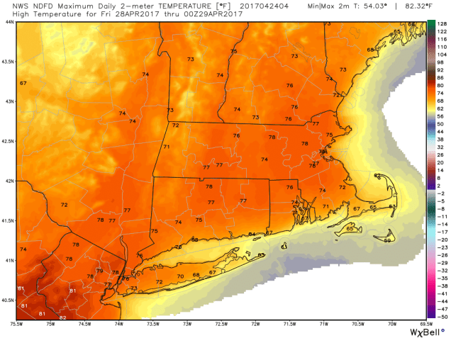
Friday: A mix of sun and clouds, chance for showers and maybe a thunderstorm late in the day. High 73-80, cooler along the coast.
Saturday: Sunshine fades behind increasing late-day clouds. Showers may develop at night. High 70-77.
Sunday: Mostly cloudy with scattered showers possible. High 52-59 along the coast, 60-67 inland.
While we’re looking at some nice weather for the end of the week, a storm system will likely be making plenty of headlines in the nation’s midsection Friday and into next weekend. Severe weather may be fairly widespread ahead of the system from the Southern Plains and Texas into the Mississippi Valley, Gulf Coast, and Southeast. Behind the system, a late-season snowstorm is possible from the Rockies into the Northern Plains. It’s still several days away, but the mountains could pick up substantial amounts of snow from this storm, with heavy snow possible in places like Denver and Rapid City.
