Easter Sunday, 1997. It’s a beautiful day with sunshine and temperatures getting into the 60s. So why are the meteorologists talking about Winter Storm Warnings? Well, as we all remember (at least those of us who lived around here at the time), we went from 60 degrees on Sunday to 2 feet of snow by Tuesday. While there’s more snow in the forecast for March 31 and April 1 this year, we’re not expecting anything remotely close to what happened 20 years ago.
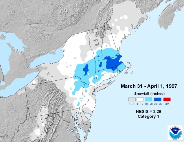
As we get into late March and early April, it becomes harder and harder to get a significant snowstorm around here. Oh sure, it’s happened plenty of times (just look at the map above), but we really need everything to be setup perfectly for it to happen. For Friday and Saturday, things are not setup perfectly, and that’s why we’re not expecting a big storm.
The storm system bringing severe weather to parts of the nation’s midsection yesterday and today will head towards the Great Lakes over the next day or two, then eventually redevelop off the Mid-Atlantic coastline on Friday. Meanwhile, high pressure building in north of us will bring sunshine and relatively cool weather in for Thursday. As that high moves into eastern Canada on Friday, it will allow winds to shift into the east and southeast across the area at lower levels of the atmosphere. As these winds blow in off the ocean, where water temperatures are in the upper 30s to lower 40s, it will allow air temperatures to rise to those same levels along the coastline.
Inland areas could be a different story. Winds may stay out of the north, allowing cold air to remain in place, keeping temperatures in the lower to middle 30s. As the precipitation moves in during the day, we’ll see it start as rain in many places, but well inland, and especially in some of the higher terrain, we’ll see snow, or at least a mix of rain and snow. Even though it may be snowing during the day, we’re not expecting much accumulation. The sun angle is getting relatively high, so even with the cloud cover, it still is strong enough to prevent much accumulation, at least on paved surfaces.

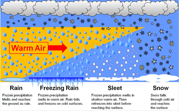
This brings us to Friday night, which is where things get very tricky. Without the sun, and with temperatures dropping a bit, along with the heaviest precipitation moving in, we’re looking at a changeover to snow for most places, and possibly some heavy snow, especially away from the coastline, right? Not exactly. Some warmer air looks like it will move in aloft for a while, about 7,000-10,000 feet above ground. With a warm layer aloft, the snow that’s falling melts, then starts to refreeze as it moves back into the colder air below that layer. The result is sleet, and possibly a lot of it.
Everything should change back to rain before ending on Saturday, but temperatures will likely only be in the 30s to lower 40s again. Not exactly a nice early Spring day across New England. A few rain or snow showers may linger into Sunday as an upper-level disturbance moves through, but sunshine should return on Monday, just in time for Opening Day at Fenway.
So, by now you’re wondering how much snow can we really expect? You’ve probably seen some of the model forecast snow maps posted on the internet or on TV already. Ignore them. All of them. They are useless in storms like this. Here’s what we’re thinking right now for accumulations:
Inside of 128: Little to no accumulation
Merrimack Valley/NH Seacoast/Northeast MA (away from the coast): 1-3″
Southern NH: 2-4″
Worcester Hills/Monadnocks: 3-6″
All in all, not a big storm, but the roads could be slick Friday night and Saturday morning, so if you have to head out during those times, please slow down and be careful. If anything changes, we’ll update this post on Thursday.
