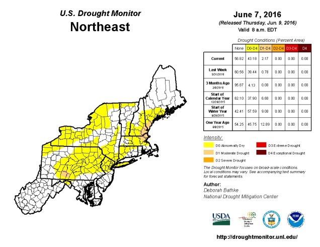
Sunshine. Fair-weather cumulus clouds. Gusty winds. Below normal temperatures. Upper-level low pressure. Low humidity. Ridge of high pressure. Above normal temperatures. All of these things are part of the forecast for at least one day this week. See anything missing from that list? Go on, give it another look. We’ll wait. Give up? If you said “rain”, then you’re correct! That’s right, we appear to have a rain-free week coming up across the area.That’s great if you’re on vacation, otherwise, not so much. You see, we’re actually in a drought around here, and it’s slowly been getting worse, because we haven’t received a lot of rain over the past few months. So, we actually need the rain.
The week will start off on the cool side with an upper-level low pressure area slowly moving across southeastern Canada. This will also provide some gusty winds for Monday and possibly Tuesday, but they won’t be as strong as we saw on Sunday. As the low pulls away and high pressure builds in, we’ll see sunshine for the latter half of the week, with temperatures gradually rising. It still doesn’t look like there’s any sustained heat in our future, but a few warm days are possible at times, especially as we head into next week.
Monday: Sunshine and some afternoon clouds, breezy. High 67-74.
Monday night: Mostly clear.Low 49-56.
Tuesday: Partly to mostly sunny. High 71-78.
Tuesday night: Clear skies. Low 52-59.
Wednesday:A mix of sun and clouds. High 74-81.
Thursday: Partly sunny.High 76-83.
Friday:A mix of sun and clouds. Just a slight chance for a pop-up shower in the afternoon. High 69-76.
Saturday: Plenty of sunshine.High 74-81.
Sunday: Mostly sunny.High 79-86.
We must note that there is the possibility that next weekend is not as sunny or mild as our forecast suggests. The ECMWF model paints a starkly different picture.

As you can see above, the ECMWF has a Nor’easter develop and slowly move up the coast, giving us windy, cool, and damp conditions from Friday into early next week. The GFS model shows this feature as well, but it has it significantly farther south, and much weaken when it does start to move northward during the first half of next week. For now, we’re leaning towards the GFS solution, but we figured we’d let you know that there is still a chance that next weekend will suck. If that chance grows at all during the week, we’ll let you know.
