Often, you’ll hear meteorologists say not to focus on the center of a tropical system, because its effects can be felt far from the center. Tropical Storm Colin is a terrific example of this.

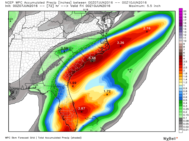
The “center” of Tropical Storm Colin is about to cross the coast of the Big Bend of Florida this evening. As of 11pm, the center was about 70 miles east of Apalachicola, Florida, moving northeast at 22 mph. Maximum sustained winds are near 50 mph. While the center is about to cross the coast, most of the thunderstorm activity is located east and northeast of the center. Heavy rain has been falling for most of the day across much of Florida as well as parts of Georgia and the Carolinas, but there have only been a few reports of tropical-storm force winds.
Tropical Storm Warnings remain in effect for the Gulf Coast of Florida from Indian Pass to Englewood, and along the Atlantic coast from Sebastian Inlet, Florida northward to Oregon Inlet, North Carolina. The current forecast from the National Hurricane Center calls for Colin to cross northern Florida and southern Georgia overnight, then move back into the Atlantic on Tuesday. Colin will likely have lost tropical characteristics by then (some would that it is already doing that), but it may still strengthen a bit as it passes offshore of the Carolinas. The main impact will be heavy rain and flooding near the coast. Flood watches are in effect for much of the region.
Once Colin or its remains pull away from the Carolinas it will head out into the open Atlantic. Aside from impacting the fish and marine traffic, the system could pass close enough to Newfoundland to bring some gusty winds and rainfall to the island later this week.
Meanwhile, the first tropical depression of the season has formed in the Eastern Pacific Ocean. As of 11pm EDT, Tropical Depression One-E was centered about 125 miles south-southwest of Salina Cruz, Mexico, heading towards the northeast at 7 mph. A Tropical Storm Watch has been posted for the coast of Mexico from Puerto Escondido to Boca De Pijijiapan.


The system is expected to remain weak while drifting towards the northeast over the next day or two. The system could dissipate before making landfall. One thing it will do is produce very heavy rainfall across southern Mexico and adjacent Central America. Rainfall totals of 5-10 inches are expected with heavier amounts possible. This will lead to flash flooding and mudslides across the region.

Closer to home, we have a possibility of severe weather around here on Tuesday. A cold front will cross the region during the afternoon, likely producing some showers and thunderstorms. Before that, we’ll have some cloud cover and showers around in the morning. If we can get enough sunshine to develop during the afternoon, it could help produce instability for another round of showers and thunderstorms, some of which could be strong to severe. Right now, it looks like the best chance for and strong storms will be from western and central Massachusetts into southern Vermont and southern New Hampshire, but again, this is dependent on how much sunshine we get. Any storms that do form may contain heavy downpours, gusty winds, and hail.
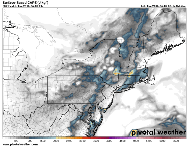
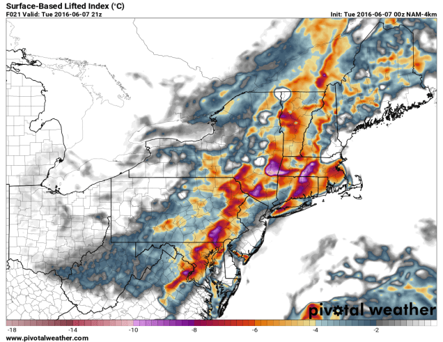
After the front moves through, cooler weather will settle in for Wednesday, but a secondary cold front may produce another round of showers and thunderstorms Wednesday afternoon. With much cooler air aloft, there’s a better chance that any storms that form on Wednesday may contain small hail, but widespread severe weather isn’t expected.
