The second tropical depression of the 2016 Hurricane Season has developed in the Western Atlantic Ocean.
As of 8pm EDT Friday, Tropical Depression Two was centered approximately 400 miles southeast of Charleston, South Carolina, and was moving towards the west-northwest at 13 mph. Maximum sustained winds are near 35 mph, and additional strengthening is expected.

The storm is expected to continue on a general west-northwest track into Saturday, with some modest strengthening possible. If the system attains maximum sustained winds of 39 mph or more, it would be named Tropical Storm Bonnie. This may occur on Saturday. However, many of the forecast models are indicating that the system may not strengthen much over the next few days, due to a combination of, wind shear aloft, and sea surface temperatures that are only marginally warm enough to sustain a tropical cyclone. Most of these models do show a track towards South Carolina over the next 24-48 hours.

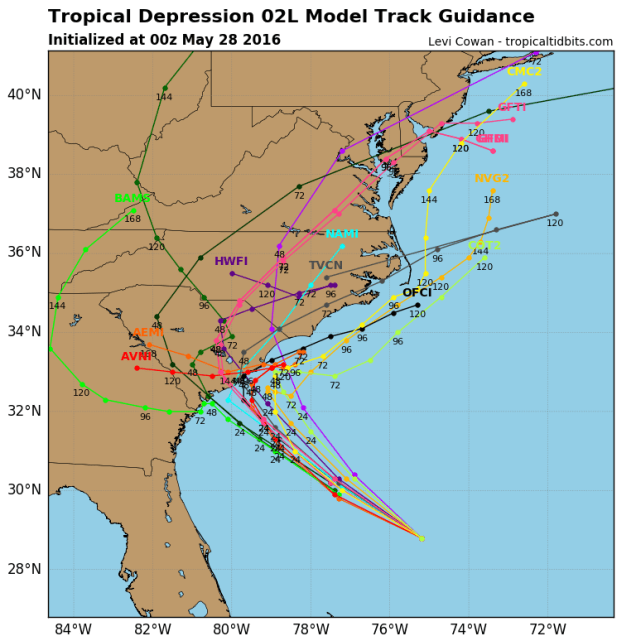
As the storm nears the coastline it will start to slow down as the upper-level steering currents start to weaken. A turn towards the north is possible, but if the turn occurs too early, it would prevent the storm from making landfall in South Carolina, but would make a landfall in southeastern North Carolina a bit more likely. Residents along the coast from Georgia to North Carolina should keep an eye on the storm’s progress, as it will likely have a significant impact on the holiday weekend forecast.
The storm will also have an indirect impact on the weekend forecast for much of the remainder of the East Coast. As the upper-level flow becomes south-to-north along the East Coast, it will take moisture from the storm and send it northward, ahead of a cold front. This will result in periods of heavy rain for the Mid-Atlantic states later on Sunday, and the Northeast on Monday. Rainfall totals of 1-2 inches or more are expected, and while it will ruin plans for barbecues and beach days, the region has not received much rain this Spring, so any moisture that does fall is needed.

So, should you cancel your Memorial Day plans? Things can obviously change, but we’d have a backup plan ready. Right now, much of the day looks to be a washout, especially the morning and early afternoon, with temperatures only in the 60s to lower 70s. The rest of the holiday weekend looks great though. Saturday will feature a mix of sunshine and clouds, with a few popup showers and thunderstorms in the afternoon. High temperatures will be in the 80s to lower 90s, with some cooler readings right along the coastline. For Sunday, a backdoor cold front will move in, with more cloud cover, though still some sunny breaks. High temperatures will only be in the 60s to lower 70s along the coast, but inland, temperatures should reach well into the 70s, with some lower 80s well inland.
