High temperatures at this time of year are normally within a degree or two of 80 for most of the region. Image provided by Weathermodels.com
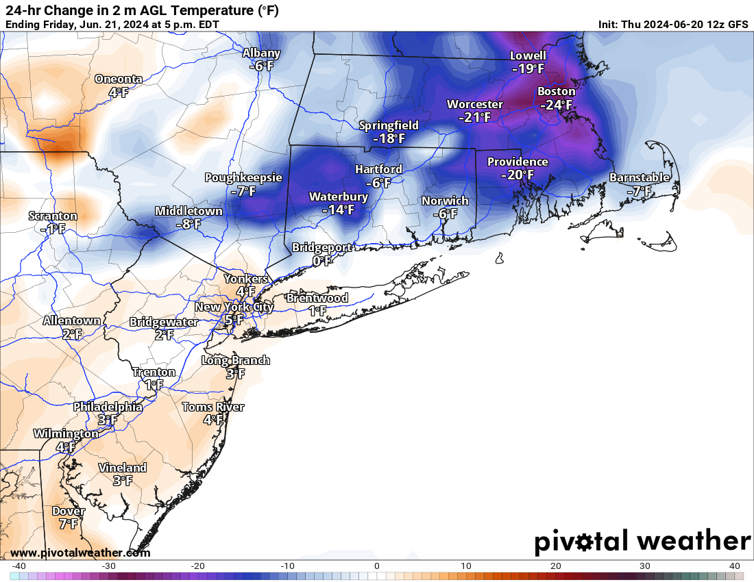
The upper-level low that brought us cool temperatures and some showers over the past few days is moving out and high pressure is building in. That will mean sunshine and warmer weather as it slides eastward over the next few days. A seabreeze will keep coastal areas cool, but as a whole, temperatures will be near to above normal through the weekend, with many inland locations topping 80 over the next few days. Humidity levels will also start to creep up, enough that you’ll probably notice it by Sunday. Clouds will start to move back in on Sunday as another weak system approaches the region. That system may produce some showers and thunderstorms late Sunday and Sunday night, but they’ll be more likely on Monday.
Showers and thunderstorms are likely on Monday, but coverage, duration, and intensity are still to be determined. Images provided by Pivotal Weather.
Thursday night: Clear and cool. Low 53-60.
Friday: Sunshine and a few afternoon clouds. High 75-82.
Friday night: Clear to partly cloudy. Low 56-63.
Saturday: Partly to mostly sunny. High 77-84.
Saturday night: Clear to partly cloudy. Low 57-64.
Sunday: A mix of sun and clouds, more humid, slight chance for a late-day shower. High 79-86.
Sunday night: Partly cloudy, chance for a few showers. Low 59-66.
Monday: Intervals of clouds and sun with scattered showers and thunderstorms. High 76-83.
Most of the weekend should feature some nice weather, thanks to Hurricane Ernesto.
Monday will feature some rather cool temperatures thanks to some rain. Image provided by Weathermodels.com
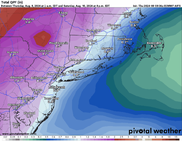
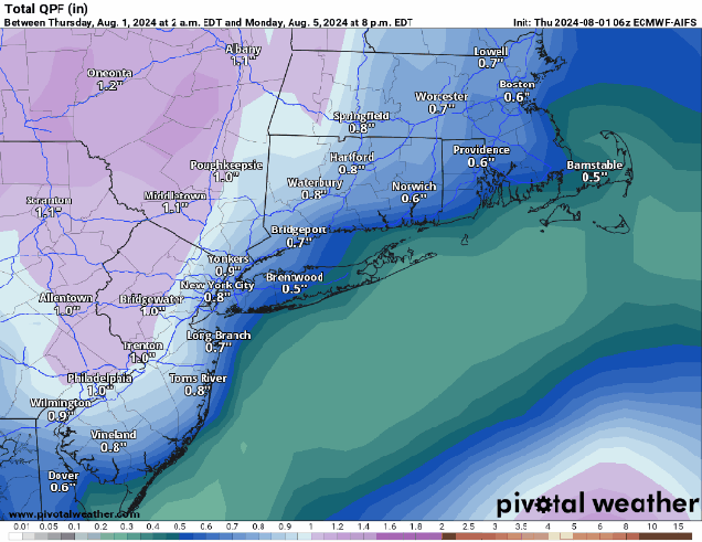
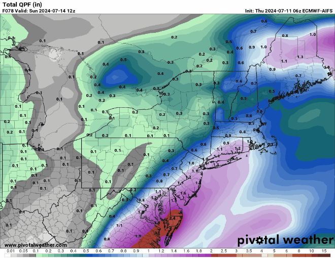
An upper-level low over Atlantic Canada will lift back out tonight, with any lingering showers or thunderstorms ending this evening. High pressure then builds in for Friday and Saturday with drier weather, though smoke drifting down from Canadian wildfires will dim the sun at times. Another upper-level low will settle into the Great Lakes, with a surface low pressure and its associated cold front slowly making their way eastward over the next few days. Hurricane Ernesto will be heading north and then northeastward well east of the region this weekend, but it will act to slow down the front, keeping us on the dry side. Some clouds will move in ahead of it, but it looks like the shower and thunderstorm activity associated with the front will hold off until late Sunday. As the front moves in, showers and thunderstorms will become more widespread Sunday night and Monday before the front moves offshore later Monday.
A slowing moving cold front will produce heavy rain at the end of the weekend, but the heaviest will stay to our west. Images provided by Pivotal Weather.
As for Hurricane Ernesto, it has Bermuda in its crosshairs at the moment. As of 5pm, Ernesto was centered about 495 miles south-southwest of Bermuda, moving toward the north at 13 mph. Maximum sustained winds were near 85 mph. The forecast calls for Ernesto to strengthen a little more tonight and Friday while heading northward, passing very close to Bermuda Friday night and early Saturday as it slows down. Beyond that, it will start to turn more toward the northeast, gradually weakening as it loses its tropical characteristics this weekend while passing south of Atlantic Canada. It could bring some heavy rain and gusty winds to parts of Newfoundland, but the bigger impact it will have, except for what it does to Bermuda, will be the large swells it generates. Rough seas are likely this weekend, with large waves smashing into the East Coast from the Carolinas northward to Atlantic Canada, resulting in hazardous conditions at the beaches and a high risk for rip currents, as well as the threat for some coastal flooding near the time of high tide, as we are approaching the astronomical high tides for the month.
Forecast track for Hurricane Ernesto. Image provided by the Canadian Hurricane Centre.
Thursday night: Showers and thunderstorms end this evening, partly to mostly cloudy overnight with areas of fog developing. Low 59-66.
Friday: A mix of sun and clouds, smoke from Canadian wildfires will dim the sun at times. High 77-84, coolest along the coast.
Friday night: Partly to mostly cloudy, patchy fog possible again. Low 60-67.
Saturday: Hazy sunshine and some afternoon clouds. High 77-84.
Saturday night: Partly to mostly cloudy. Low 62-69.
Sunday: More clouds than sun, some showers and thunderstorms may develop in the afternoon. High 75-82.
Sunday night: Cloudy with showers and thunderstorms becoming more likely. Low 62-69.
Monday: Plenty of clouds with more showers and thunderstorms. High 73-80.
Despite what the app on your phone says, most of the weekend will actually be rather pleasant.
What’s left of Debby will pass well north and west of us Friday night. Images provided by the National Hurricane Center.
What’s left of Debby will head northward tonight, sending a warm front across the region. Some showers may accompany it, but you’ll notice humidity levels increasing once again. Temperatures may actually rise a few degrees overnight as winds shift into the southeast and south. Ex-Debby will pass well north and west of the region Friday and Friday night, keeping us in the warm and humid side ahead of the storm. We’ll have some occasional showers during the day on Friday, but it won’t be a washout. Some steadier and potentially heavier showers are likely Friday night into early Saturday as Ex-Debby crosses northern New England and drags a cold front across our area. The showers end Saturday morning, then we’ll clear out in the afternoon, with gusty west to northwest winds ushering drier air in, though it will remain quite warm. High pressure then builds in for Sunday and Monday with sunshine, warm temperatures, and comfortable humidity levels.
There may be some heavier downpours, but for the most part, the models do not bring heavy rain into the region for Friday. Images provided by Pivotal Weather.
Thursday night: Cloudy with a few showers likely. Low 60-67 during the evening, temperatures may rise a bit after midnight.
Friday: Mostly cloudy, some occasional showers at times, becoming breezy in the afternoon. High 77-84.
Friday night: Mostly cloudy, breezy, showers becoming more widespread with some heavier downpours and a few rumbles of thunder. Low 69-76.
Saturday: Breezy with showers and thunderstorms ending in the morning (early afternoon across Cape Cod), becoming partly to mostly sunny. High 81-88, a little cooler across Cape Cod.
Saturday night: Clear to partly cloudy. Low 58-65.
Sunday: Sunshine and a few clouds, not as humid. High 76-83.
While some people may Ride the Lightning this weekend, we certainly won’t be Trapped Under Ice.
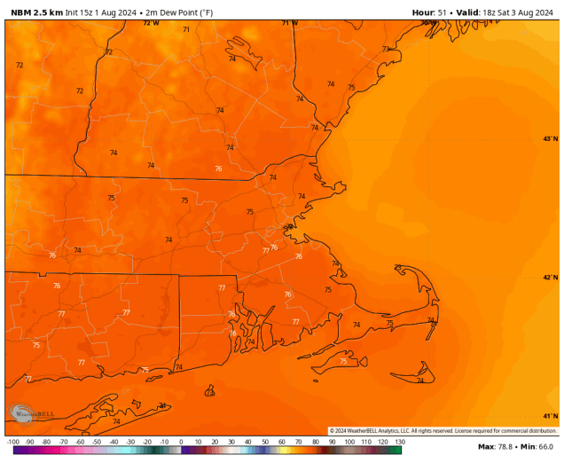
Dewpoints could get well into the 70s on Saturday. Image provided by WeatherBell.
It’s Sad But True, that humidity will remain in place for much of the weekend, as a Bermuda remains anchored offshore, just as it has for a good chunk of the summer so far. It’s enough to drive you Stone Cold Crazy if you don’t like heat and humidity. Just a couple of stray showers or thunderstorms are possible, but most of us will stay dry. As we head into Saturday, an upper-level disturbance will head toward the region, bringing in more clouds, which will keep temperatures a little lower, but it will remain humid, which will Fuel a chance for showers and thunderstorms. A cold front moves in on Sunday, with more showers and thunderstorms likely. With the humid air in place, any showers or storms both Saturday and Sunday could produce heavy rain in some spots. Despite the fact that we’re expecting showers and thunderstorms both days, neither day will be a washout, so Wherever You May Roam, don’t cancel any outdoor plans you may have, but you should keep an eye to the sky (or on the radar), to plan your Escape if need be. The front moves through, and drier air moves in for Monday giving us One day that isn’t humid., but will stay fairly warm. A second cold front moves through late in the day, possibly triggering another shower or thunderstorm, but for the most part, Monday, should be a dry day.
Most of the models show the potential for a decent amount of rain this weekend, but activity could be more hit-and-miss than widespread. Images provided by Pivotal Weather.
Thursday night: Clear skies. Low 67-74.
Friday: Sunny in the morning, then clouds start to move in with a late-day shower or thunderstorm possible. High 88-95, a little cooler near the South Coast and Cape Cod.
Friday night: Partly to mostly cloudy with a few showers or thunderstorms. Low 68-75.
Saturday: Partly sunny with some showers and thunderstorms around. High 84-91, a little cooler near the South Coast and Cape Cod.
Saturday night: Partly to mostly cloudy, a few more showers or thunderstorms possible. Low 68-75.
Sunday: Intervals of clouds and sun, chance for showers and thunderstorms. High 81-88.
Sunday night: Any showers or storms end in the evening, becoming partly cloudy. Low 65-72.
Monday: A mix of sun and clouds, just a slight chance for a late-day shower or thunderstorm. High 84-91.
In terms of the weather, this will be one of the best weekends all summer.
Climatologically, these are the warmest days of the year. Image provided by Weathermodels.com
A cold front will push offshore this evening, then high pressure builds in, with sunshine, lower humidity, and seasonably warm temperatures for Friday and the weekend. By Monday, things may change. Earlier, it was looking like it would be dry and more humid, but the latest models are all showing the potential for a weak storm system off the coast, which would bring in some clouds and showers. We’re a little skeptical about such a change from one run to the next, but nearly all of the models are showing it, so Monday may not be as great as we originally were thinking.
Monday may not turn out to be such a great day after all. Images provided by Pivotal Weather.
Thursday night: Any lingering showers end this evening, then skies clear out overnight. Low 59-66.
Friday: Plenty of sunshine, not as humid. High 78-85.
Friday night: Clear skies. Low 58-65.
Saturday: More sunshine. High 81-88, a little cooler near the coast.
Saturday night: Clear skies. Low 59-66.
Sunday: Sunny. High 83-90, a little cooler along the coast.
Sunday night: Clear during the evening, increasing clouds late at night. Low 60-67.
Monday. More clouds than sun with a chance of showers. High 77-84.
A drier and quieter weather pattern will be in place through the weekend.
Dewpoints will drop into the 50s and lower 60s across the region on Friday. Image provided by WeatherBell.
High pressure builds in for Friday and only slowly moves eastward, pushing offshore by the end of the weekend. That means we’ll stay dry into at least Sunday and likely Monday. A weak disturbance will bring in some clouds on Saturday, but any shower activity should remain well north and west of our area. While temperatures will remain seasonably warm, humidity levels will drop for Friday and Saturday, but then start to slowly creep up again for Sunday and Monday. A weak frontal boundary will try to drop down from the north later Sunday and Monday with a few more clouds, but it doesn’t look like it will make it through, and there probably won’t be any shower activity associated with it aside from possibly a stray shower or two Monday afternoon.
Temperatures this weekend will be near to a little above normal. Image provided by Weathermodels.com
Thursday night: Skies become clear, less humid. Low 59-66, maybe a little warmer across Cape Cod.
Friday: Sunshine and just a few stray clouds. High 79-86.
Friday night: Clear skies, some clouds start to filter in late at night. Low 60-67, a little warmer across Cape Cod.
Saturday: Partly sunny. High 81-88.
Saturday night: Partly cloudy. Low 63-70.
Sunday: A mix of sun and clouds. High 83-90.
Sunday night: Partly cloudy. Low 61-68.
Monday: Partly sunny, a little more humid, slight chance for a pop-up shower. High 83-90.
Hot and humid weather continues into a good chunk of next week across the region.
Dewpoints will peak in the mid 70s on Saturday. Image provided by WeatherBell.
A Bermuda High will remain anchored offshore for the next several days, with southwest winds continuing to pump very warm to hot and humid conditions into the region. A stray shower or thunderstorm is possible on Friday, but a weak boundary will move in Friday night, bringing a better chance for some widespread showers and thunderstorms late Friday night into Saturday morning. Some of these storms could produce heavy rainfall, with some localized flooding possible. We’ll start to clear out late Saturday, with a drier day likely on Sunday. It’ll still be hot, and on the humid side, but not quite as humid as recent days. By Monday, humidity levels will creep back up, with a few showers and thunderstorms possible in the afternoon.
Many of the models are showing the potential for some heavy rainfall amounts for at least parts of the region on Saturday. Images provided by Pivotal Weather.
Thursday night: Clear to partly cloudy. Low 66-73.
Friday: A mix of sun and clouds, slight chance for a shower or thunderstorm, a little breezy in the afternoon. High 85-92, a little cooler near the South Coast and Cape Cod.
Friday night: Becoming mostly cloudy with showers and thunderstorms developing after midnight. Low 68-75.
Saturday: Showers and thunderstorms likely, some of them heavy in the morning, then skies start to clear out late in the day. High 80-87, a little cooler across Cape Cod.
Saturday night: Becoming clear. Low 65-72.
Sunday: Sunshine and a few clouds. High 86-93, a little cooler across Cape Cod.
Sunday night: Clear skies. Low 66-73.
Monday: A mix of sun and clouds, a shower or thunderstorm is possible. High 87-94, a little cooler across the South Coast and Cape Cod.
The long weekend will feature typical summertime weather – warm temperatures, moderate to high humidity, and a daily chance for pop-up showers and thunderstorms.
Dewpoints will get well into the 70s around here on Saturday. Image provided by WeatherBell.
After a couple of warm but dry days, we’ll see humidity levels increasing over the next few days thanks to southwest winds. A weak front will move in for the Fourth of July, but it won’t ruin any plans you may have. It will bring in some clouds, but only a few widely scattered showers and/or thunderstorms. So, keep an eye to the sky if you’ve got outdoor plans, but don’t go cancelling them, as most places will remain dry. Some patchy dense fog is likely Thursday night, especially near the South Coast, but it shouldn’t impact any fireworks displays. Friday looks like a typical summertime day with partly sunny skies, warm and humid conditions, and a few pop-up showers or thunderstorms. Another weak system moves in for Saturday, resulting in a very humid day, with a better chance for showers and thunderstorms, especially late in the day and at night. Sunday and Monday will be similar to Friday, with intervals of sun and clouds, fairly humid conditions (but not as humid as Saturday), and a few widely scattered showers and thunderstorms each afternoon.
Hurricane Beryl is approaching the south coast of Jamaica this afternoon. Loop provided by NOAA.
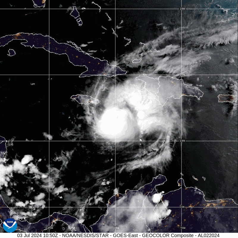
Meanwhile, in the tropics, Hurricane Beryl is barreling towards Jamaica this afternoon. As of 2pm, Beryl was centered about 45 miles south of Kingston, Jamaica, moving toward the west-northwest at 18 mph. Maximum sustained winds were near 140 mph, making Beryl a Category 4 hurricane. It is the strongest storm to impact Jamaica since Hurricane Dean in 2007. Damaging winds, torrential rain, and flooding are likely across Jamaica for the rest of the afternoon and evening, especially southern portions of the island, then Beryl will head toward the Cayman Islands tonight. Beyond that, it will continue across the Caribbean while gradually weakening before another likely landfall in the Yucatan Peninsula early Friday. It should weaken over the Yucatan, but it will move back into the Gulf of Mexico late Friday, then could strengthen once again. The models are split on whether it continues westward into Mainland Mexico or makes it a right turn and heads for southern Texas, but we’ll worry about that later this week.
After Jamaica, Beryl will head towards the Cayman Islands and the Yucatan Peninsula. After that, things ger murky. Loop provided by Tomer Burg.
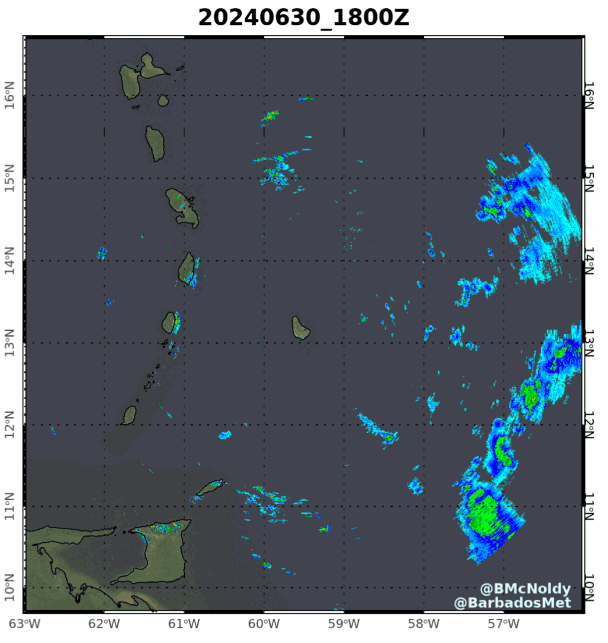
Beryl has been shattering records over the past several days even before crossing the Windward Islands. It is the strongest storm ever in the Atlantic during the months of June and July. It is the earliest Category 5 hurricane ever in the Atlantic (by more than 2 weeks). It was the strongest storm to ever cross the Southern Windward Islands when it moved across Carriacou Island on Monday with top winds near 140 mph. Sea surface temperatures are well above normal across the Atlantic and Caribbean, which aided in Beryl getting so strong, but it also featured upper-level conditions that were nearly ideal for development and strengthening, which is not that common during June and July.
Radar loop from Barbados showing Beryl’s approach and passage. Loop provided by Brian McNoldy/University of Miami.
Wednesday night: Partly cloudy. Low 59-66.
Thursday: Partly sunny, more humid, slight chance for a shower. High 80-87, a little cooler near the coast.
Thursday night: Partly to mostly cloudy with a few showers possible and some patchy fog developing. Low 63-70.
Friday: Partly sunny, slight chance for a shower or thunderstorm. High 83-90, a little cooler across Cape Cod.
Friday night: Mostly cloudy, chance for a few showers. Low 64-71.
Saturday: More clouds than sun, very humid, chance for a few showers or thunderstorms. High 77-84.
Saturday night: Partly to mostly cloudy with a few showers or thunderstorms. Low 66-73.
Sunday: A mix of sun and clouds. High 85-92, a little cooler across Cape Cod.
Sunday night: Partly cloudy. Low 63-70.
Monday: Intervals of sun and clouds. High 84-91, a little cooler across Cape Cod.
More wet weather is on the way to close out June, but the weekend won’t be a washout.
Friday will be a refreshingly dry day with dewpoints only in the 40s across the region. Image provided by WeatherBell.
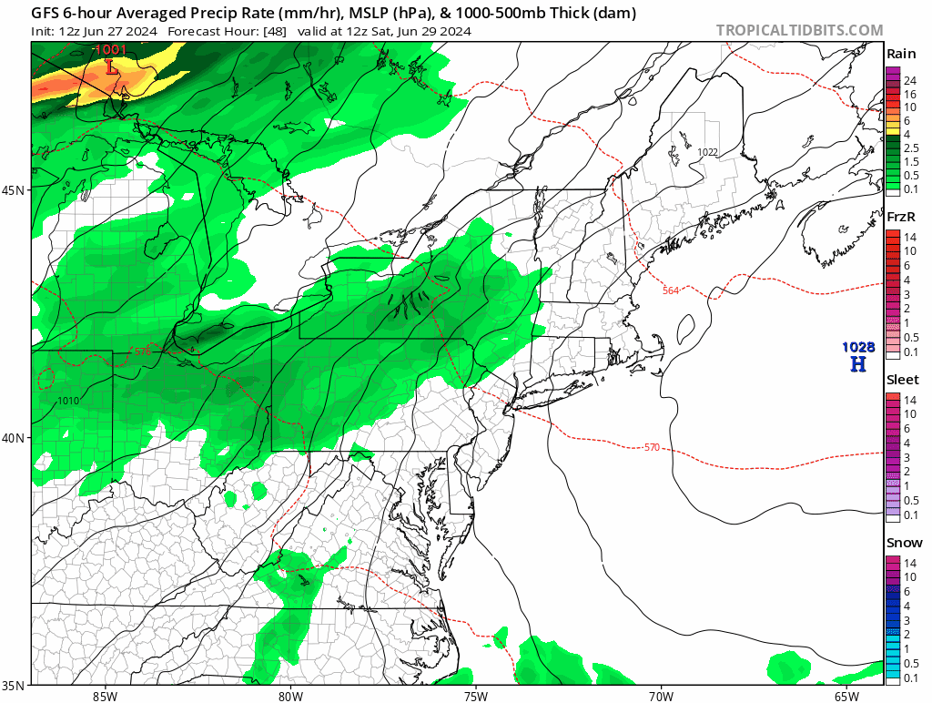
High pressure continues to build in for tonight and Friday with generally dry weather and seasonably mild temperatures. As the high slides offshore, warm and humid weather will move back in Friday night and Saturday along with clouds as a cold front approaches from the west. Most of Saturday should remain dry, albeit warm and humid, but another round of showers and thunderstorms will move in by evening, and continue overnight and into a good chunk of Sunday. The cold front moves through later Sunday, bringing an end to the shower activity, with drier weather pushing in behind it. High pressure builds back in for Monday with sunshine, cooler temperatures, and lower humidity once again.
Most of the rain this weekend will fall Saturday night and Sunday morning. Loop provided by Tropical Tidbits.
Thursday night: Clear and cool. Low 51-58.
Friday: Plenty of sunshine. High 71-78.
Friday night: Becoming partly cloudy. Low 54-61.
Saturday: Some morning sun, then skies become mostly cloudy and humid with some showers and thunderstorms possible by evening, breezy. High 73-80.
Saturday night: Cloudy and breezy with showers and thunderstorms likely. Low 63-70.
Sunday: Breezy with showers and thunderstorms ending, some clearing may take place late in the day. High 81-88.
The heat will relent for the weekend, but the humidity will take a bit longer.
Friday afternoon temperatures will be 15-25 cooler than this afternoon across the region. Image provided by Pivotal Weather.
Today will be the last hot and humid day for a bit across the region, with some strong to severe thunderstorms bringing an end to the heat this afternoon and evening. The main threats with these storms are heavy downpours and gusty winds. Tonight will remain warm, but a backdoor cold front moves through on Friday, ushing much cooler air in, as winds shift into the northeast, and blow in over the still relatively cool Atlantic. Highs on Friday will only be in the 70s and 80s, warmest near the South Coast, where we’ll still get warm in the morning before the front moves through. Dewpoints will drop a bit, but will likely remain in the 60s, so it’ll be on the humid side still. Some showers are likely ahead of the front as well. The front stalls out near or just south of the region on Saturday, resulting in a rather comfortable day, but with a decent amount of clouds. On Sunday, that front will try to lift northward as a warm front once again, bringing the very warm and humid air back in. However, a disturbance moving in from the west will likely help to produce some showers and thunderstorms during the afternoon and evening. A cold front moves through on Monday, with warm, humid conditions ahead of it in the morning, along with more showers and thunderstorms, then cooler and drier air starts to move in by late in the day behind the front.
Dewpoints remain fairly high through the weekend, then finally start to drop late Monday. Loop provided by WeatherBell.
Thursday night: Showers and thunderstorms ending shortly after sunset, remaining partly to mostly cloudy overnight. Low 65-72.
Friday: Partly sunny with some showers likely. High 82-89 in the morning, turning cooler in the afternoon.
Friday night: Mostly cloudy, a few additional showers, mainly during the evening. Low 61-68.
Saturday: More clouds than sun, a few showers possible. High 77-84, a little cooler along the coast, especially the North Shore and NH Seacoast.
Saturday night: Mostly cloudy, chance for a shower. Low 60-67.
Sunday: Intervals of clouds and sun, breezy, showers and thunderstorms possible late in the day. High 83-90, cooler across the South Coast and Cape Cod.
Sunday night: Partly to mostly cloudy, showers taper off during the evening. Low 65-72.
Monday: A mix of sun and clouds, some showers around during the morning. High 79-86, a little cooler across Cape Cod.