Weekend Outlook: June 13-16, 2025

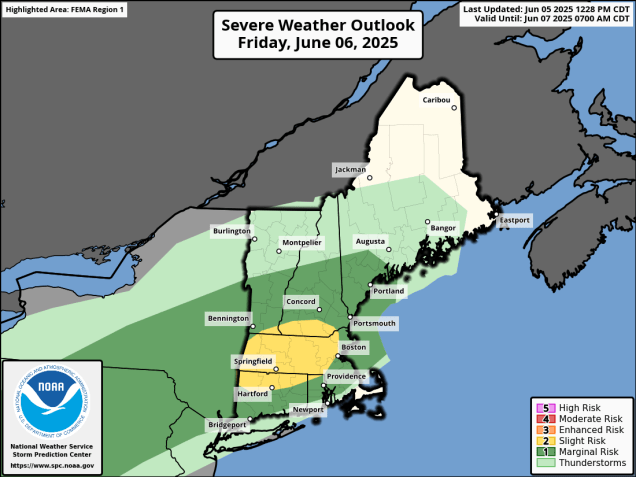
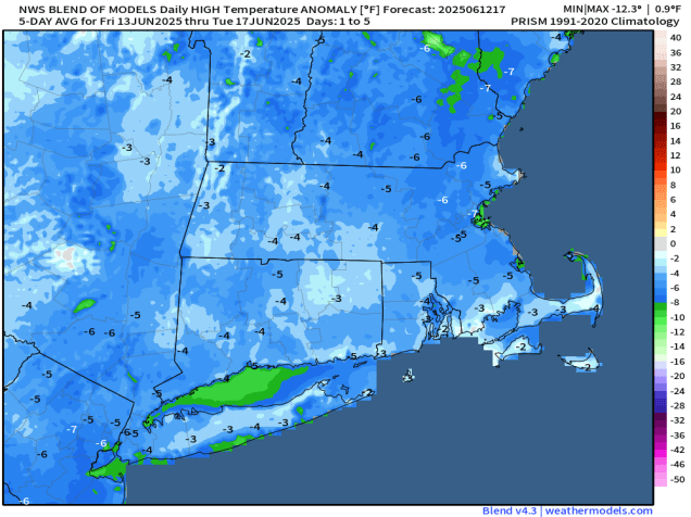
The calendar says it’s mid-June, but the forecast feels like Groundhog Day, because for the 13th week in a row, we’re here to tell you that it’s going to rain on Saturday.

No matter which model you look at, they all have rain for at least part of the region Saturday morning. Images provided by Pivotal Weather.

After a warm day today we have a cold front moving through with just some clouds and possibly a stray shower through the evening. That front will settle just offshore and stall out, with cooler weather filtering in behind it for Friday, with temperatures running 10-15 degrees cooler than today, close to or a little below where we should be in mid-June. Friday should be dry, with sunshine filtered through some high clouds. A weak area of low pressure will ride along the front Friday night and early Saturday, bringing some rain into the region along with rather cool conditions. The rain should taper off during the morning, but east winds off the Atlantic will keep clouds in place Saturday afternoon with a little drizzle at times, and temperatures only in the 60s, possibly upper 50s near the coast. For Sunday and Monday, we’ll be stuck in between high pressure to the north and another weak low pressure system riding along that front to our south. The result will be plenty of clouds, possibly a few showers, and temperatures remaining on the cool side, though Monday will likely be a little milder. The good news is that temperatures should warm up quite a bit as we get towards the middle of next week.

Temperatures will be cooler than normal for the next few days. Image provided by weathermodels.com

Thursday night: Slight chance for a shower near the South Coast during the evening, otherwise clear to partly cloudy with increasing clouds late at night. Low 55-62.

Friday: A mix of sun and clouds. High 72-79, a little cooler across Cape Cod.

Friday night: Becoming mostly cloudy, showers develop after midnight. Low 52-59.

Saturday: Cloudy and much cooler with showers likely before midday, then a few showers and some patchy drizzle in the afternoon. High 60-67.

Saturday night: Mostly cloudy. Low 49-56.

Sunday: More clouds than sunshine, slight chance for a shower or some drizzle. High 62-69, coolest along the coast.

Sunday night: Partly to mostly cloudy. Low 51-58.

Monday: Mostly cloudy, a few sunny breaks, some showers possible, mainly late in the day. High 67-74.

Weekend Outlook: June 6-9, 2025

Someone call Ripley, because Believe It or Not, there’s rain in the forecast for part of the weekend.

More rain is expected for parts of the region Friday and Saturday. Image provided by WeatherBell.

After a hot and somewhat humid day today, changes are on the way as a slow-moving cold front makes its way toward the region. We’ll see clouds become more numerous tonight and Friday, with some showers and thunderstorms likely on Friday, especially in the afternoon, and mainly north of the Mass Pike. Some of these storms may produce strong winds and heavy rain which could lead to areas of flooding, so if you’ve got outdoor plans, keep an eye on the radar. It’ll still be quite warm and humid, but not as hot as today.

Some severe storms are possible on Friday, especially across the interior. Image provided by the Storm Prediction Center.

The cold front finally moves through on Saturday, accompanied by some additional showers, but they shouldn’t be that heavy. They’ll also be accompanied by cooler temperatures behind the front. Sunday will be the pick of the weekend as high pressure builds in with more comfortable conditions, though there will still be some clouds around as an upper-level disturbance crosses the region. We also have more smoke from Canadian wildfires drifting in on Sunday, resulting in hazy skies at times. Monday is a little uncertain at the moment. Many of the models had been showing high pressure remaining in control with a weak low pressure system passing well to the south, but some of those models are bringing the system a lot farther northward now, possibly bringing in more showers on Monday. We’re going to be cautiously optimistic for now that it should remain mostly dry, but with low confidence.

Will high pressure or low pressure be in control on Monday? Images provided by Pivotal Weather.

Thursday night: Partly to mostly cloudy, a few showers or thunderstorms possible during the evening. Low 61-68.

Friday: Some morning sun, otherwise becoming mostly cloudy with showers and thunderstorms developing, some could produce heavy downpours and strong winds. High 78-85, cooler along the coast.

Friday night: Mostly cloudy, showers and thunderstorms wind down before midnight. Low 57-64.

Saturday: Plenty of clouds with more showers likely. High 70-77.

Saturday night: Any lingering showers end in the evening, then becoming partly cloudy. Low 54-61.

Sunday: Intervals of clouds and hazy sunshine. High 70-77, cooler across Cape Cod.

Sunday night: Partly to mostly cloudy. Low 52-59.

Monday: Partly sunny. High 66-73.

Weekend Outlook: May 30 – June 2, 2025

Stop us if you’ve heard this before, but there’s some rain on the way for part of the weekend.

Rainfall has been above normal across the region for most of climatological Spring. Image provided by weathermodels.com

A weak low pressure area pulls away from the region tonight, taking any lingering showers with it. Friday looks like a decent day with some sunshine and warm temperatures, but a weak disturbance moving across the region could produce a shower or thunderstorm during the afternoon. After that, we turn our attention to an area of low pressure heading this way from the southwest. It will bring in some rain for Friday night and Saturday morning, some of which could be heavy, though it looks like the heaviest rain will stay just west of our area. We get into a bit of a lull Saturday afternoon, then another disturbance brings in more showers and possible some thunderstorms Saturday evening and night. High pressure starts to build in on Sunday with drier and cooler weather, but with an upper-level low also moving in, we’ll see some clouds and possibly a popup shower or two. Monday should be the nicest day of this stretch, with mostly sunny skies and temperatures running a little below normal for this time of year.

Most of the models are depicting some heavy rainfall totals for parts of New England this weekend. Images provided by Pivotal Weather.

Sunday marks not only the beginning of climatological summer, but also the start of hurricane season. While there’s nothing imminent, we did take a look at what to expect this season and explained how extremely overdue we are for a storm to head towards New England and our annual start of hurricane season post that was published yesterday.

Thursday night: Partly to mostly cloudy, any lingering showers end in the evening. Low 51-58.

Friday: Becoming partly sunny, chance for an afternoon shower or thunderstorm. High 69-76, cooler along the South Coast and Cape Cod.

Friday night: Mostly cloudy with rain developing, possibly heavy overnight. Low 52-59.

Saturday: Rain tapers off in the morning, some sunny breaks may develop in the afternoon. High 64-71.

Saturday night: Mostly cloudy with another round of showers and thunderstorms, ending overnight. Low 47-54.

Sunday: A mix of sun and clouds, slight chance for a shower, breezy. High 61-68.

Sunday night: Clear to partly cloudy. Low 45-52.

Monday: Sunshine and some afternoon clouds. High 65-72.

Weekend Outlook: May 23-26, 2025

We’ve reached Memorial Day Weekend – “The Unofficial Start of Summer”, but it won’t feel like summer for most of the time.

Low pressure will bring more rain and gusty winds in tonight. Loop provided by Tropical Tidbits.

A late-season nor’easter will slowly pull away from the region tonight and Friday, with rain and gusty winds continuing tonight, then winding down on Friday as the storm moves into the Gulf of Maine. So, the rest of the weekend is better, right? In the words of Lee Corso “Not so fast my friend”. We’ll still be under the influence of that storm, but we’ll also have an upper-level low pressure area moving into the Northeast. This means we’ll still have plenty of clouds, a few showers, and cool temperatures (but not as cool as today) into Saturday. Sunday should be a little better, with slightly milder conditions, less in the way of shower activity, but still a decent amount of clouds. As we head into the holiday on Monday, high pressure will build in, so it will be drier and milder, but with that upper-level low nearby, we can’t completely rule out the chance for another pop-up shower in the afternoon.

Memorial Day will be milder, but still cooler than normal around here. Image provided by weathermodels.com

Thursday night: Periods of rain, some of it heavy, windy. Low 39-46.

Friday: Rain tapers off to showers in the morning, clouds and a few glimpses of sunshine in the afternoon with a few more showers possible, still breezy in the morning, especially near the coast. High 50-57.

Friday night: Partly to mostly cloudy with more showers, especially before midnight. Low 43-50.

Saturday: More clouds than sun with some additional showers possible. High 53-60.

Saturday night: Becoming partly cloudy. Low 42-49.

Sunday: Partly sunny, chance for a few pop-up showers. High 57-64.

Sunday night: Partly cloudy. Low 43-50.

Monday: A mix of sun and clouds, just a slight chance for an afternoon shower. High 64-71.

Weekend Outlook: May 16-19, 2025

Unsettled weather is expected at times during the weekend, but no washouts are expected.

Recent rain has mitigated drought conditions for much of the region. Image provided by the National Drought Mitigation Center.

A weak low pressure area will start to pull away tonight with any lingering showers ending this evening, but areas of low clouds and fog will hang around overnight. Once the fog burns off Friday morning skies will become partly sunny, setting up a rather nice day with temperatures well into the 70s away from the South Coast, possibly topping 80 in some areas. A late-day shower or thunderstorm can’t be ruled out, mainly well north and west of Boston. A backdoor cold front may try and slide down the coast, bringing some cooler air into the New Hampshire Seacoast and the North Shore before it stalls out. Saturday will feature lots of clouds, with some showers and thunderstorms likely during the afternoon and evening as a cold front approaches the region. Some of these storms could produce gusty winds and heavy downpours, and possibly some hail. The front moves through overnight, with some clearing behind it. We’ll turn a little cooler on Sunday, but with an upper-level low pressure area crossing the region we’ll still have some clouds and possibly a few showers. Monday should feature partly sunny skies, but with the upper-level low nearby there is still a chance for a shower or two.

Most of the rain this weekend shouldn’t be that heavy. Image provided by WeatherBell.

Thursday night: Showers end in the evening, then mostly cloudy overnight with areas of dense fog developing. Low 54-61.

Friday: Becoming partly sunny, chance for a late-day shower or thunderstorm, mainly across the interior. High 74-81, cooler along the coast.

Friday night: Partly to mostly cloudy, fog may redevelop. Low 54-61.

Saturday: Mostly cloudy, showers and thunderstorms developing, mainly in the afternoon. High 69-76, cooler across Cape Cod and also from the North Shore to the New Hampshire Seacoast.

Saturday night: Showers and thunderstorms ending, some clearing late at night. Low 52-59.

Sunday: Partly sunny, chance for a few showers in the afternoon, breezy. High 66-73.

Sunday night: Partly cloudy. Low 47-54.

Monday: A mix of sun and clouds, just a slight chance for a shower, breezy. High 62-69.

Weekend Outlook: May 9-12, 2025

The weather pattern will significantly improve for the second half of this weekend. Of course, that means that the first half of the weekend won’t be that great.

Friday’s temperatures will be 10-15 degrees below normal for much of the region. Image provided by weathermodels.com

An upper-level low pressure system will move towards the Northeast tonight, triggering a few showers across the region. At the same time, a surface low pressure area will start to move up the coast. Ahead of that low, easterly winds off the still cool-Atlantic, combined with the rain the storm system will generate, will result in a very cool day on Friday, with temperatures likely not budging much from what they drop to tonight. Temperatures will only be in the 50s, with areas north of the Mass Pike and also along the east coast likely staying in the upper 40s. If the low-pressure system tracks across southeastern Massachusetts, as some models show, then temperatures could briefly spike into the 60s across that region, but this is far from certain. As for the rain, it looks like the steadiest and heaviest rain holds off until afternoon, but occasional showers are likely during the day. Rain continues Friday night, ending from southwest to northeast Saturday morning and early afternoon as the storm system moves into the Gulf of Maine. Some showers may linger into the afternoon, especially across southern New Hampshire, but we should finally start to see some clearing by evening. High pressure then builds in with sunshine and milder weather for both Sunday and Monday.

Much of the region could pick up 1-2 inches of rain between now and Saturday evening. Image provided by WeatherBell.

Thursday night: Mostly cloudy with some showers likely. Low 45-52.

Friday: Cloudy with more showers, becoming a steadier rain during the afternoon. High 48-55, possibly milder across parts of Rhode Island and southeastern Massachusetts.

Friday night: Rain likely. Low 44-51, possibly milder across parts of Rhode Island and southeastern Massachusetts.

Saturday: Showers ending by early afternoon, some clearing may start to develop late in the day, especially across Rhode Island and southern Massachusetts, becoming breezy. High 58-65.

Saturday night: Becoming clear. Low 45-52.

Sunday: Plenty of sunshine. High 64-71.

Sunday night: A few clouds around. Low 40-47.

Monday: More sunshine. High 69-76, cooler along the South Coast and Cape Cod.

Weekend Outlook: April 25-28, 2025

It’s a weekend, so that must mean it’s going to rain.

We’re still experiencing drought conditions, so we need the rain. Image provided by the National Drought Mitigation Center.

We’ve got a low pressure area heading toward the Great Lakes, sending a warm front our way. A few showers may accompany that front across southern New Hampshire this evening, otherwise we’ll remain dry, setting up a rather mild Friday. While there will be some sunshine, it could be dimmed by smoke and haze drifting up from the large wildfires in New Jersey. That warm front may stall out and/or drift southward a bit on Friday, bringing cooler air back to the New Hampshire Seacoast and the North Shore, but otherwise, most places away from the South Coast should reach 70 once again. Clouds thicken up Friday night ahead of the low pressure area, with some rain moving in by daybreak. Saturday shouldn’t be a complete washout, but it will be fairly damp. Rain is likely through the morning, then there may be a bit of a lull by early afternoon, before another batch of showers accompanies a cold front late in the day. Some clearing is expected Saturday night, but an upper-level low moving across the Northeast on Sunday will generate more clouds, possibly a shower or two, and bring in cooler temperatures. High pressure returns on Monday with drier and milder conditions.

Smoke and haze from the fires in New Jersey may drift across our area tonight and Friday morning. Loop provided by WeatherBell.

Thursday night: Chance for an evening shower across southern New Hampshire, otherwise partly cloudy. Low 48-55.

Friday: Partly sunny with some haze or smoke around in the morning, clouds thicken up during the afternoon. High 72-79 inland, 64-71 along the coast, a little cooler across the Outer Cape and Islands. Temperatures may turn cooler for a while in the afternoon from Boston northward, especially along the coast.

Friday night: Mostly cloudy, rain developing towards daybreak. Low 48-55.

Saturday: Cloudy and breezy with showers likely, tapering off late in the day. High 61-68, cooler across the South Coast, Cape, and Islands.

Saturday night: Becoming partly cloudy. Low 41-48.

Sunday: Partly sunny, breezy, slight chance for an afternoon shower. High 52-59.

Sunday night: Becoming clear. Low 41-48.

Monday: Plenty of sunshine. High 65-72, cooler across the Cape and Islands.

Weekend Outlook: April 18-21, 2025

Some warmer weather is on the way, but it won’t last too long.

We’ve got some great weather for baseball on tap for Monday morning.

High pressure remains in control into Friday with clear skies and seasonably cool temperatures tonight. We’ll start to warm up a bit on Friday, but also see clouds move in ahead of a weak upper-level disturbance and a warm front. The upper-level disturbance may produce a late-day shower across parts of southern New Hampshire and northern Massachusetts, but most of us will still dry. Low pressure heading into the Great Lakes will send a warm front our way Friday night, with a better chance for showers across the region. Behind the front, we’ll have a significant warmup on Saturday, with many locations away from the South Coast topping 70, but southwest to south winds will keep the South Coast and Cape Cod in the 60s or even 50s, as water temperatures remain rather chilly. Across inland locations, if we get enough sunny breaks, some places may even break 80. A cold front moves through late in the day, possibly producing a few more showers. High pressure builds in behind the front for Easter Sunday with breezy and cooler weather, but many locations will still top 60. For Patriots Day on Monday, we’ll see clouds moving back in with some showers by evening as another system approaches, but again we should top 60, cooler along the coast thanks to seabreezes.

Saturday is shaping up to be a very warm day. Image provided by WeatherBell.

Thursday night: Clear skies. Low 33-40.

Friday: Morning sunshine, then increasing and thickening clouds in the afternoon, slight chance for a late-day shower from the Merrimack Valley northward, becoming breezy. High 60-67, except 52-59 along the South Coast and Cape Cod.

Friday night: Mostly cloudy and breezy with scattered showers. Low 47-54, temperatures may start to rise after midnight.

Saturday: Clouds and some sunny breaks, slight chance for a late-day shower, breezy. High 74-81 inland, 66-73 near the South Coast, 58-65 across Cape Cod.

Saturday night: Mostly cloudy with a few showers during the evening, skies start to clear out late night. Low 48-55.

Sunday: Sunshine and a few clouds, breezy. High 58-65.

Sunday night: Partly cloudy. Low 35-42.

Monday: Morning sun, then increasing clouds, showers possibly towards evening. High 55-62 except 47-54 along the immediate coast and across Cape Cod.

Weekend Outlook: April 11-14, 2025

Another dreary weekend is on the way for the region, and there may even be some snow for parts of the region.

Some much-needed rain is on the way for the weekend. Image provided by Weathermodels.com

Low pressure will head toward the Mid-Atlantic states tonight, sending some showers our way. Across the interior, well north and west of Boston, temperatures will be marginally cold enough for the rain to change to snow, especially in the hills of Worcester County and the Monadnocks, but also some of the lower elevations outside of I-495. We’re not expecting any accumulation, though it wouldn’t be a shock if there was a coating on some grassy surfaces. The showers should taper off towards daybreak. and Friday will just be a cloudy day with a few stray showers possible. The low over the Mid-Atlantic states starts moving our way Friday night, with some steadier and heavier rain moving in, and continuing for much of Saturday. Again, we’ll have some marginally cold air in place Friday night, so we could see more snow mixing in, with a coating possible on grassy surfaces outside of 495, and possibly a little more than that in the hills of Worcester County and the Monadnocks once again. Saturday will be a rather chilly day with northeast winds keeping temperatures in the upper 30s and lower 40s for much of the region. Combine that with the rain, and it won’t be a great day to be outside. The rain tapers off Saturday night, but as that system starts moving toward the northeast and passes offshore, it could possibly bring in some more rain on Sunday, especially for eastern Massachusetts and Rhode Island. That system pulls away Sunday night and high pressure briefly builds in for Monday with some sunshine and milder conditions.

Accumulating snow should be confined to the hills, but there could be a coating on grassy surfaces across the interior. Image provided by WeatherBell.

Thursday night: Cloudy with some showers developing, possibly mixed with snow across the interior. Low 32-39.

Friday: Cloudy and becoming breezy with a few showers possibly, mainly in the morning. High 43-50, coolest along the coast.

Friday night: Cloudy and breezy with rain developing, mixed with snow across the interior. Low 31-38.

Saturday: Breezy with periods of rain. High 37-44.

Saturday night: Rain tapers off the showers. Low 33-40.

Sunday: Cloudy and breezy with more showers possible, favoring eastern Massachusetts and Rhode Island. High 44-51, coolest across southeastern Massachusetts and Cape Cod.

Sunday night: Any showers end in the evening, becoming partly cloudy overnight. Low 34-41.

Monday: Partly sunny. High 56-63, cooler across Cape Cod.

Weekend Outlook: April 4-7, 2025

The weather looks fantastic for the Red Sox home opener at Fenway tomorrow, but the rest of the weekend doesn’t look that great.

The home opener at Fenway means summer isn’t far away.

A cold front will cross the region this evening, possibly accompanied by a few showers tonight. The front settles south of New England on Friday, with some clearing taking place from north to south. Temperatures will remain mild, which is good news if you’re heading to Opening Day at Fenway. For first pitch at 2:10pm, skies will be partly sunny, winds out of the northwest at 10-15 mph (blowing from left field to right field), and the temperature will likely be in the lower 60s. Clouds will start to stream back in late Friday night as that frontal system starts lifting northward once again. Saturday is looking like a rather cool day with northeast to east winds off the ocean, and rain developing toward midday. Occasional periods of rain and showers are likely into the nighttime hours before tapering off. The front will lift through as a warm front on Sunday, but how far north it gets is still a question mark. Areas south of Boston should have a very mild afternoon, but how warm it gets north of Boston, especially into southern New Hampshire, is uncertain. If the warm front does get that far north, temperatures could get well into the 60s. If not, it could stay in the 50s or even upper 40s all afternoon. We’ll have some spotty showers at times, but the day shouldn’t be a washout. Another low pressure area moves through later in the day and at night with more rain likely. That system drags a cold front through at night, with cooler air moving in behind the system on Monday. Showers should gradually end during the day as the system moves offshore.

Sunday’s temperatures are dependent on the northward progress of a warm front. Images provided by Pivotal Weather.

Thursday night: Mostly cloudy with a few showers possible, mainly south of the Mass Pike. Low 46-53.

Friday: Any lingering showers near the South Coast end early, followed by gradual clearing from north to south. High 58-65.

Friday night: Partly cloudy through the evening, clouds increase and thicken up after midnight. Low 35-42.

Saturday: Mostly cloudy and cooler with rain developing. High 41-48, temperatures may drop a little in the afternoon.

Saturday night: Rain tapers off to showers. Low 35-42, temperatures may start to rise after midnight.

Sunday: Plenty of clouds with a few showers possible. High 55-62, possibly warmer south of Boston.

Sunday night: Cloudy with more rain and showers. Low 36-43.

Monday: Mostly cloudy, showers ending. High 44-51.