Another dry weekend coming up? Where were these during the summer?
If you were up early enough this morning, some parts of the region had some sleet or even a few wet snowflakes for the first time this season. Don’t worry, they won’t be back for a while. Any lingering rain showers will end this evening, and while we may see a little clearing overnight, clouds quickly return on Friday as an upper-level disturbance moves across the region. Could there be a shower or two? It’s possible, but for the most part, it just be cloudy, breezy, and cool. High pressure builds in for the weekend with lots of sunshine, but again, temperatures will remain on the cool side. Another upper-level disturbance brings clouds back in on Monday, but again, we should remain dry for the most part, with only a few stray showers expected.
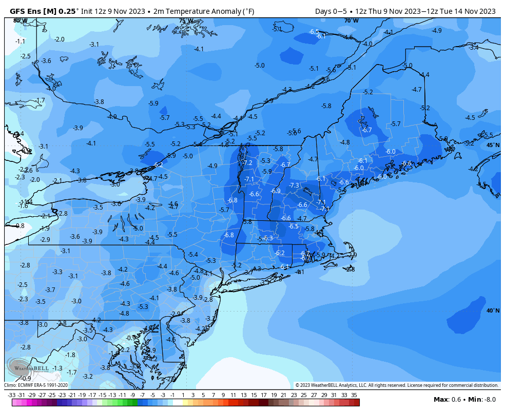
Temperatures will be well below normal through the weekend. Image provided by WeatherBell.
Thursday night: A lingering shower this evening, then becoming partly cloudy. Low 33-40.
Friday: Mostly cloudy, slight chance for a shower, skies start to clear out late in the day, breezy. High 45-52.
Friday night: Clear skies. Low 31-38.
Saturday: Sunshine and a few clouds. High 43-50.
Saturday night: Clear to partly cloudy. Low 25-32.
Sunday: Partly to mostly sunny. High 38-45.
Sunday night: Clear to partly cloudy. Low 23-30.
Monday: Morning sun, increasing afternoon clouds, slight chance for a late-day shower. High 42-49.
The warm weather continues into the start of the weekend, but big changes are on the way.
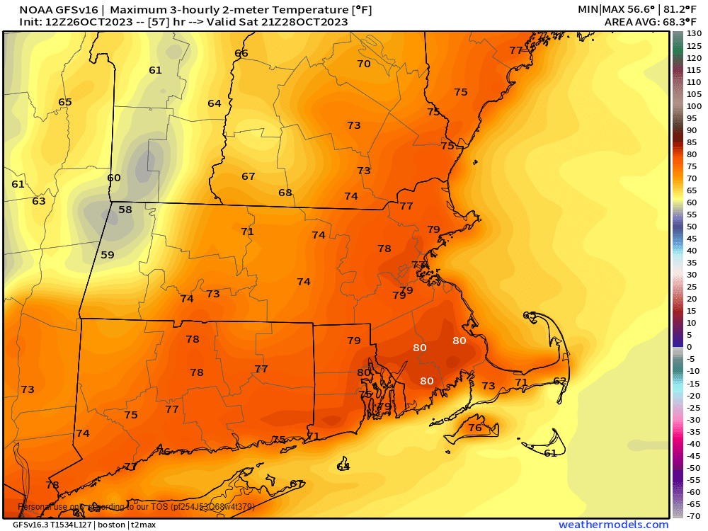
Temperatures could reach 80 in some spots on Saturday. Image provided by Weathermodels.com
A ridge of high pressure remains in control through Saturday, keeping temperatures well above normal. In fact, with plenty of sunshine both Friday and Saturday, we may make a run at 80 degrees in some spots. Friday night will be rather mild, with our low temperatures fairly close to our normal high temperatures for late-October. A cold front moves through Saturday evening, with clouds streaming in along with it. Sunday will feature plenty of clouds, and it will turn much cooler, but we’ll still be close to normal for this time of year. A wave of low pressure riding along the front brings in some rain during the afternoon. Occasional showers will continue for Sunday night and a good chunk of Monday as the cooler air continues to filter in. As the wave and the front push farther offshore later Monday, we may see some clearing develop as high pressure starts to build in. A much cooler pattern settles in for next week with below normal temperatures. Some of the models show the potential for a storm later Tuesday into Wednesday which may not be all rain if you’re well inland, and could impact trick-or-treating Tuesday evening, but we’ll get into more detail on that in our Weekly Outlook Monday morning.
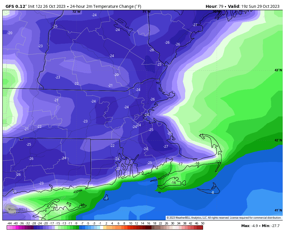
Sunday afternoon will be 20-25 degrees cooler than Saturday afternoon across the region. Image provided by WeatherBell.
Thursday night: Partly to mostly cloudy. Low 53-60.
Friday: Becoming mostly sunny and warm. High 73-80.
Friday night: Clear skies. Low 54-61.
Saturday: Sunshine and a few clouds, breezy, and warm. Clouds may start to increase late in the day. High 73-80.
Saturday night: Becoming partly to mostly cloudy and turning cooler. Low 43-50.
Sunday: Cloudy and much cooler with showers developing in the afternoon. High 54-61.
Sunday night: Occasional showers. Low 44-51.
Monday: Showers gradually ending, some clearing possible late in the day. High 55-62.
For a change, it’s going to rain this weekend. The forecast itself isn’t that simple though, so let us explain.
A cold front in the Midwest and a trough of low pressure off the South Carolina coast will be the main players in our weather for the next few days. Image provided by NOAA.
High pressure slides off to the east tonight and clouds start to stream in ahead of a cold front currently crossing the Great Lakes. Meanwhile, a weak area of low pressure will begin to develop off the Carolina coast tonight and head northward. Ahead of both of these, we’ll have a cloudy but mild day on Friday. Some showers are possible during the day, but the bulk of the activity should stay to our west. Showers will become more widespread by evening as the low pressure area to the south draws closer. The combination of the low and the approaching front will produce widespread showers with some bouts of steadier rain through Friday night and Saturday morning, tapering off during the afternoon. While the rain won’t be heavy, some places could see an inch or so by the time it winds down. By Saturday night, the cold front and the low pressure area move offshore, but an upper-level disturbance will move into the Northeast. This will allow the low to slow down or even stall out in the Gulf of Maine while intensifying. This may keep the showers around across parts of Southern Maine and Southern New Hampshire, possibly northern Massachusetts as well, but for most of us, it’ll just be a blustery and cool day with only a few showers around.
Sunday could end up as another damp day according to some of the models. Images provided by Pivotal Weather.
High pressure finally starts to build in for Monday with some clearing, but it will remain breezy and cool. In fact, as winds subside Monday night, and skies become clear, we’ve got a chance for our first widespread frost of the fall. So, if you’ve got some outdoor plants, you may want to prepare to bring them inside.
Monday night will be the coolest night we’ve had around here since the middle of May. Image provided by WeatherBell.
Thursday night: Increasing clouds. Low 46-53.
Friday: Mostly cloudy, chance for a few showers. High 60-67.
Friday night: Cloudy with showers likely. Low 52-59.
Saturday: Cloudy with occasional showers and some periods of steadier rain. High 57-64.
Saturday night: Partly to mostly cloudy, showers ending in the evening, becoming breezy. Low 45-52.
Sunday: More clouds than sun, windy, cooler, more showers possible, especially from the Merrimack Valley northward. High 52-59.
A weekend without rain? Those have been rare since June, but for many of us, it will be a reality this weekend.
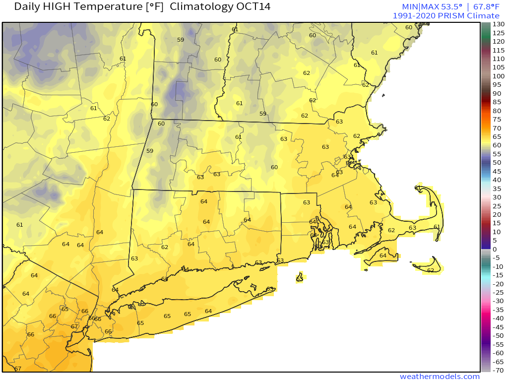
Average high temperatures for mid-October are in the lower to middle 60s. Images provided by Weathermodels.com
A weak cold front will cross the region this evening with little fanfare. Behind it, northwest winds will usher some cooler air in for Friday, but we’ll also have a decent amount of sunshine, with seasonably cool temperatures. Low pressure will then start to move out of the Great Lakes and head toward the Mid-Atlantic states. That will send some clouds in for Saturday, but the low should be far enough to the south that most of the rain stays offshore as well. A few showers are possible later Saturday into early Sunday near the South Coast, and there could be a little drizzle near eastern coastal locations, but for the most part we’ll stay dry. We may see a bit more sunshine on Sunday, but clouds come back Monday as another system moves off the Mid-Atlantic coastline. This may bring in a few showers on Monday, but it looks like most of the rain from this system likely holds off until Tuesday.
Some models bring the rain to the South Coast Saturday evening, some don’t. Images provided by Pivotal Weather.
Thursday night: A few clouds and possibly a stray shower during the evening, otherwise clear. Low 40-47.
Friday: Mostly sunny, breezy. High 57-64.
Friday night: Clear during the evening, some clouds move in overnight. Low 41-48.
Saturday: Becoming partly to mostly cloudy, a late-day shower possible near the South Coast. High 57-64.
Saturday night: Partly to mostly cloudy, a shower or two possible near the South Coast. Low 41-48.
Sunday: More clouds than sunshine, breezy. High 56-63.
Sunday night: Partly to mostly cloudy. Low 43-50.
Monday: Mostly cloudy, breezy, chance for a shower or two. High 55-62.
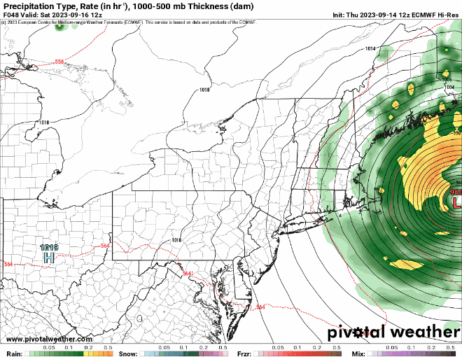
Another rainy Saturday? Yup, we’ve got another rainy Saturday on the way.
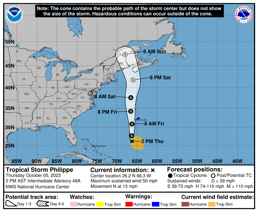
Tropical Storm Philippe may have a role in our weather this weekend. Image provided by the National Hurricane Center.
We start off with another foggy night tonight, with plenty of moisture around and high pressure sliding off to the east. Once the fog burns off Friday morning, we’ll still have plenty of clouds ahead of a cold front slowing moving in from the west. A few showers are possible during the day, but they’ll become more likely at night, and through a good chunk of the day on Saturday. Complicating matters is Tropical Storm Philippe, or what’s left of it. It will be moving northward, passing east of the region, but some of the rain from it could move into eastern Massachusetts. Eventually, it’ll get tugged northwestward by an upper-level low (more on that in a minute), moving into Maine or New Brunswick this weekend, with some heavy rain and gusty winds for parts of northern New England. The cold front moves across the region Saturday evening, bringing an end to the rain, then much cooler air settles in behind it. However, that upper-level low over southeastern Canada will move southeastward, which means that despite high pressure building in at the surface, we’ll still have plenty of clouds around Sunday and Monday, with a few popup showers possible.
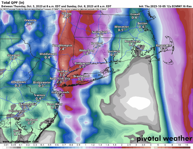
The heaviest rain will stay well to our west, but there is the potential for some heavy rain in eastern New England this weekend. Images provided by Pivotal Weather.
Thursday night: Becoming mostly cloudy with areas of fog, some of it dense. Low 54-61.
Friday: Partly to mostly cloudy with a chance for a shower or two. High 67-74.
Friday night: Cloudy with showers developing. Low 57-64.
Saturday: Periods of rain and showers. High 61-68.
Saturday night: Showers end, some clearing possible late at night, becoming breezy. Low 46-53.
Sunday: A mix of sun and clouds, windy, cooler. High 57-64.
We’ve got a rather complicated forecast coming up as we officially end astronomical summer and begin fall with the autumnal equinox at 2:50am Saturday.
Fall officially begins early Saturday morning. Image provided by CBS News.
High pressure to our north will keep us dry and seasonably cool into Friday. However, high clouds will begin to stream northward from what is currently being called “Potential Tropical Cyclone 16”, but will likely be named Ophelia soon. Whether it is tropical or subtropical doesn’t have much impact on the forecast. Future Ophelia will likely strengthen a bit before moving into eastern North Carolina early Saturday.
Forecast track for Potential Tropical Cyclone 16. Image provided by the National Hurricane Center.
As our high pressure system moves off to the east, southerly flow will send the rain up the East Coast. This is where things get tricky, because another high pressure area will also be trying to build in from the northwest. We’ve seen this setup many times before, and what usually happens is that the high wins out and keeps most of the rain (or snow in the winter) off to our south. However, anytime there’s been a chance for rain this summer, we’ve ended up with a lot of rain. So, taking both of those ideas into account, here’s what we think will happen:
The rain will move up the coast on Friday and Friday night, but will have a tough time moving in early Saturday with plenty of dry air in place. Eventually, the rain will win out, overspreading the region during the afternoon. How far north it gets is still a big question, and it wouldn’t be a surprise to us if the rain never made it across the MA/NH border. Some of the rain may be heavy during the late afternoon and evening, especially south of the Mass Pike. The rain may taper off for a while Saturday night and early Sunday as the second high tries to build in, and the low to the south moves up into the Mid-Atlantic states. A second batch of showers is possible later Sunday and Sunday night as the low starts to turn more toward the northeast, eventually passing out to sea south of New England on Monday, with some additional showers possible.
Heavy rain is likely across parts of the region this weekend, but how far north is still in doubt. Images provided by Pivotal Weather.
Thursday night: Clear skies, though some high clouds will start to move in. Low 47-54.
Friday: Sunshine filtered through high clouds in the morning, clouds thicken up in the afternoon. High 65-72.
Friday night: Mostly cloudy. Low 49-56.
Saturday: Showers developing from south to north during the late morning and early afternoon, becoming a steady and potentially heavy rain by late afternoon. High 58-65 during the morning, temperatures drop into the 50s during the afternoon.
Saturday night: Rain tapers off to showers during the evening, mostly cloudy overnight. Low 49-56.
Sunday: Plenty of clouds, some showers may redevelop during the afternoon. High 60-67.
Sunday night: Cloudy with showers likely. Low 50-57.
Monday: Mostly cloudy, more showers around, especially during the morning. High 61-68.
All eyes are on Hurricane Lee and what impact it will have on the region over the next few days.
Lee is passing well west of Bermuda this afternoon. Loop provided by NOAA.
Hurricane Lee was centered about 710 miles south of Nantucket at 2pm, moving toward the north at 14 mph. Maximum sustained winds were near 85 mph. A Tropical Storm Warning is in effect for Cape Cod and the Islands as well as coastal Plymouth County, with a Tropical Storm Watch for the rest of Massachusetts and Rhode Island, as well as the Seacoast of New Hampshire and the southern Maine coastline. A Storm Surge Watch is also in effect for Cape Cod Bay and Nantucket. Lee will continue northward for the next 24 hours, gradually weakening as it feels some increasing wind shear and starts to move over cooler waters. A slightly bend toward the northwest is possible late Friday as an upper-level low moves into southern Canada, but it should eventually start to turn more toward the northeast, likely becoming extratropical as it makes landfall in Nova Scotia at tropical storm strength.
Most of the models keep Lee well east of the region, with rain mostly along the coast Saturday morning. Images provided by Pivotal Weather.
High clouds ahead of Lee will stream into the region tonight, and they will thicken up on Friday as winds start to increase as the pressure gradient between and a high pressure area to our northwest tightens up. The worst of the storm will be between Midnight and about Noon on Saturday. Most of the rain will be confined to Cape Cod and the immediate coastline, with just a few showers penetrating farther inland. With northeast to northerly winds, eventually become northwest Saturday afternoon, the only places where storm surge will be an issue is north-facing shorelines, where the Storm Surge Watch is in effect. While large waves will batter the coastline for the next few days, a storm surge of 2-4 feet above the normal tides will impact the north shore of Cape Cod and northern Nantucket. As for those winds, we’re looking at sustained winds of 30-50 mph for parts of Cape Cod and the Islands with gusts to 60 mph or more, and 20-30 mph sustained winds near the eastern Massachusetts coast with gusts of 40-50 mph possible. Farther inland, winds will be a little weaker than that. Overall, Saturday will be a windy day, with some rain mainly near the coast, something we’ve experienced hundreds, if not thousands, of times. In the grand scheme of things, this is not a big deal for 95% of our region.
Peak wind gusts will generally be in the 35-45 mph range for most of the region, except for the Cape and Islands. Image provided by WeatherBell.
Once Lee starts to pull away, skies will clear out Saturday night and winds will start to diminish, setting up a fantastic Sunday with sunshine and warm temperatures. Clouds will start to move back in by evening as a weak disturbance starts to approach from the west. That system may produce a few showers on Monday, but temperatures will remain mild.
Thursday night: Increasing clouds. Low 51-58.
Friday: Mostly cloudy, becoming breezy. High 65-72.
Friday night: Cloudy and windy with showers developing near the coast, some steadier and heavier rain across Cape Cod. Low 54-61.
Saturday: Windy with rain and showers ending around midday, skies may start to clear out late in the day. High 65-72.
Saturday night: Clearing with diminishing winds. Low 53-60.
Sunday: Sunshine and some afternoon clouds, still breezy in the morning. High 72-79.
Sunday night: Becoming partly to mostly cloudy. Low 55-62.
Monday: Intervals of clouds and sun with a chance for a few showers. High 71-78.
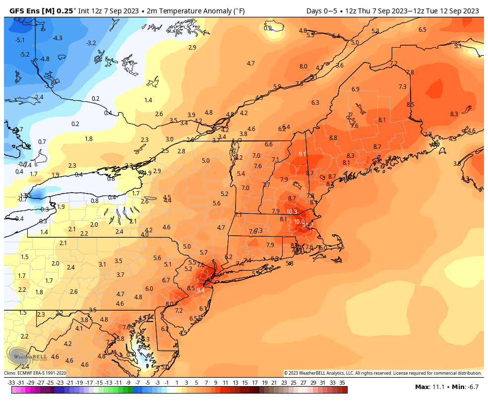
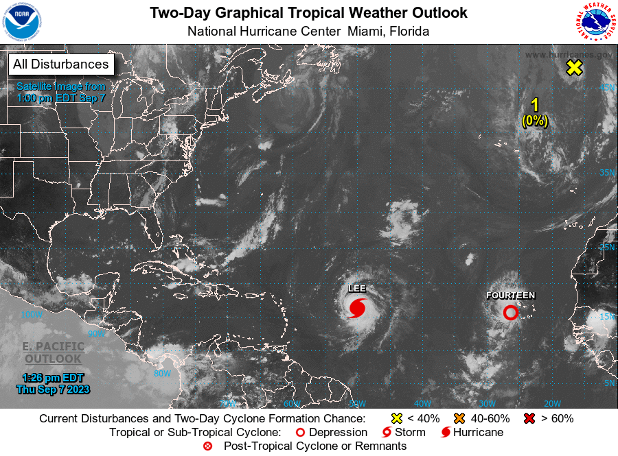
While the heat will fade away over the next few days, the humidity won’t, and there’s some rain in our future as well. Meanwhile, we’ve got Hurricane Lee and a new Tropical Depression in the Atlantic.
Temperatures will average 5-10 degrees above normal for the next few days. Image provided by WeatherBell.
High pressure will move offshore and sit there for the next several days while a frontal system very slowly moves eastward from the Great Lakes. In between the two, southerly winds will keep us warm and rather humid right through the weekend. We’ll have a little more cloud cover over the next few days, which will keep temperatures a little lower, but still likely into the 80s each afternoon for many locations. A few showers or thunderstorms are possible during the next few afternoons and evenings, but most of them should stay north and west of our area. Sunday and Monday is the more likely timeframe for showers and thunderstorms to develop around here, as the cold front will finally be approaching our neighborhood. Sunday is the home opener for the Patriots, so a lot of people are interested in that forecast. While there will likely be some showers and possibly thunderstorms around, whether they will impact the game (or the tailgating) is a little tough to pin down at this point, so if you’re heading to Foxborough, best to plan for it, but hope it doesn’t materialize. Temperatures will likely be in the upper 70s at kickoff, and it will be quite humid.
Many of the models have some showers around at the time of kickoff on Sunday. Images provided by Pivotal Weather.
Thursday night: Increasing clouds, patchy fog developing, slight chance for a shower during the evening from southern New Hampshire into central Massachusetts. Low 66-73.
Friday: Partly sunny, a shower or two possible during the afternoon, mainly from southern New Hampshire into central Massachusetts. High 83-90.
Friday night: Partly to mostly cloudy. Low 67-74.
Saturday: Intervals of clouds and sun, a few showers possible into the afternoon, mainly north and west of I-495. High 79-86.
Saturday night: Mostly cloudy, chance for a shower or two. Low 66-73.
Sunday: More clouds than sun with some showers and thunderstorms likely, mainly north and west of I-95. High 76-83.
Sunday night: Mostly cloudy with some showers around, mainly during the evening. Low 64-71.
Monday: Partly to mostly cloudy with scattered showers and thunderstorms likely. High 75-82.
Hurricane Lee was joined by Tropical Depression 14 this afternoon. Image provided by the National Hurricane Center.
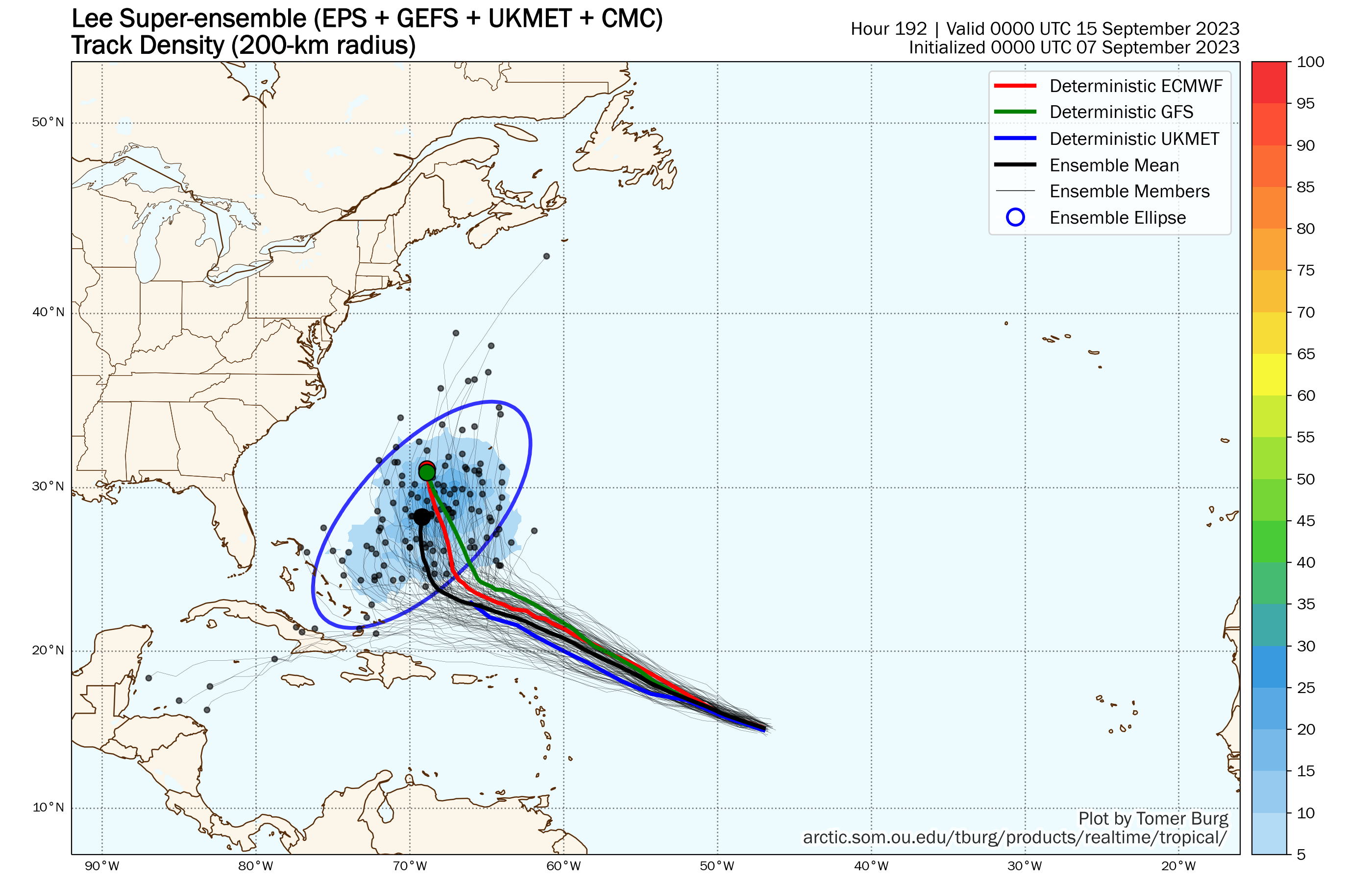
Hurricane Lee will be grabbing headlines for the next several days and rightfully so. As of 11am, Lee had maximum sustained winds near 105 mph, making it a Category Two hurricane. It was centered about 870 miles east of the Northern Leeward Islands, moving toward the west-northwest at 15 mph. There is little wind shear over Lee, and extremely warm waters that extend deep into the ocean, which means conditions are ideal for Lee to continue to rapidly strengthen, and the forecast from the National Hurricane Center calls for Lee to become a Category 5 hurricane with winds near 160 mph by Friday evening. Lee should continue on a west-northwest track, passing north of the Caribbean this weekend. After that, things get a little trickier. Lee will likely start to see its intensity fluctuate over the weekend as eyewall-replacement cycles begin to develop. As for its track, a west-northwest track will continue into the weekend, but it will start to slow down as it reaches the western edge of a ridge of high pressure. At this point, a turn more toward the northwest or north will likely develop. When that turn takes place will be key to the forecast next week. There has already been considerable hype on the internet about Lee threatening the East Coast next week. We’ll just say this. It is FAR too early to speculate on where Lee will be heading 7-10 days from now. Is there a chance Lee could threaten the East Coast or Atlantic Canada? Yes, there is, but it’s not a likely scenario at this point. Even if it does threaten the East Coast, it is not likely to be the Category 5 monster it will develop into this weekend.
Ensemble forecasts for the track of Hurricane Lee over the next week. Image provided by Tomer Burg
Meanwhile, Tropical Depression 14 has developed in the eastern Atlantic. As of 11am, TD 14 was centered about 160 miles west of the Cabo Verde Islands, moving toward the west-northwest at 17 mph. Maximum sustained winds were near 35 mph. The system is expected to steadily strengthen, likely become a Tropical Storm tonight or Friday, and possibly reaching hurricane strength over the weekend. The forecast calls for it to eventually turn more toward the northwest and north, staying over open water the entire time.
Forecast track for Tropical Depression 14. Image provided by the National Hurricane Center.
We’ll post a special blog about the tropics with a deeper dive into Lee’s future either Friday or Saturday.
While the tropics remain active, our weather pattern definitely isn’t.
High pressure will remain in control through Saturday, providing plenty of sunshine, but keeping temperatures cool, though we’ll start to moderate over the weekend. A weak disturbance will bring in some clouds late Saturday and Saturday night, but high pressure builds back in for Sunday and Labor Day with more sunshine, warmer temperatures, but also more humidity.
Thursday night: Clear skies. Low 48-55.
Friday: Plenty of sunshine. High 69-76.
Friday night: Clear skies. Low 52-59.
Saturday: Sunshine and some late-day clouds. High 74-81.
Saturday night: Partly cloudy. Low 58-65.
Sunday: Early clouds, then becoming sunny. High 79-86, a little cooler near the South Coast.
Sunday night: Clear to partly cloudy. Low 60-67.
Labor Day: Sunshine and a few clouds. High 81-88, a little cooler near the South Coast.
There are still three named storms in the Atlantic. Image provided by Environment Canada.
Meanwhile, we have three named storms in the Atlantic, but only one may still be a threat to land.
Tropical Storm Idalia has moved off the North Carolina coast and is weakening. As of 2pm, it was centered about 120 miles southeast of Cape Lookout, North Carolina, moving toward the east at 20 mph. Maximum sustained winds were near 65 mph. Idalia is starting to interact with a frontal system just to the north and will likely become an extratropical system later today or tonight. However, that’s likely not the end of Idalia’s story. It will continue eastward, and as it moves over the warmer waters of the Gulf Stream, it may start to regain tropical characteristics and possibly strengthen again. It could be a threat to Bermuda this weekend, but beyond that, its future is a little murky. The steering currents may collapse, and Idalia could stall out and/or drift around near Bermuda. Many models have it start moving toward the northeast and out to sea, but this is hardly a lock. It will continue to generate some rough surf for the East Coast into next week.
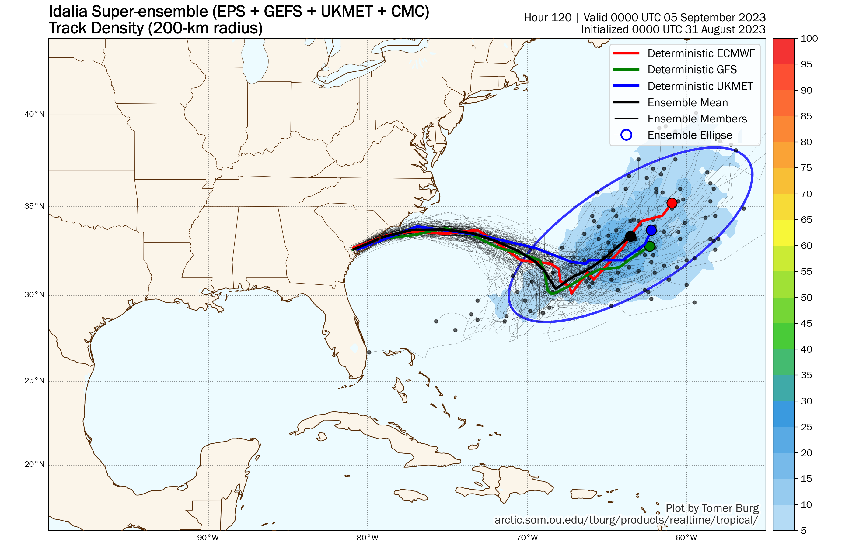
Idalia;s future beyond the weekend is uncertain. Image provided by Tomer Burg.
Farther to the east, Hurricane Franklin continues to pull away from Bermuda this afternoon. As of 11am, Franklin was centered about 265 miles northeast of Bermuda, moving toward the east-northeast at 14 mph. Maximum sustained winds were still near 100 mph. Franklin’s future is fairly straightforward. It will head northeastward over open water while slowly weakening and losing tropical characteristics over the next few days without impacting any land areas.
Forecast track for Hurricane Franklin. Image provided by the National Hurricane Center.
We also have Tropical Storm Jose in the Atlantic. As of 11am, Jose was centered about 770 miles east of Bermuda, moving toward the north at 7 mph. Maximum sustained winds were near 40 mph. Jose is expected to continue northward and weaken, and it will likely be absorbed by Franklin over the next day or two.
A system in the eastern Atlantic could become a tropical depression over the next few days, but isn’t a threat to land. Image provided by Tropical Tidbits.
Way out in the Atlantic is an area of low pressure just west of the Cabo Verde Islands. It is slowly organizing, and conditions are favorable for more development. It could become a tropical depression by this weekend. Whether it develops or not, steering currents should send the system northwestward over open water through the weekend with no threat to any land areas.
More rain is on the way, but most of the weekend should end up rather nice.
Rainfall totals over the past few months have been 1.5 to 3 times the normal amount. We’ll add to that tonight and Friday. Image provided by WeatherBell.
Low pressure is moving across the Great Lakes this afternoon, and it will slowly head eastward, sending clouds into the region today, with rain developing tonight. Friday is looking like a cloudy, breezy, cool, and wet day ahead of the system, with episodes of rain and showers, possibly a few embedded thunderstorms, especially near the South Coast. The system will try to send a warm front across the region, but it doesn’t look like it’ll make too much progress northward, so most of us will stay cool, except areas closer to the South Coast. Some of the rain may be heavy during the day on Friday. The rain will taper off Friday night, but it may not end until Saturday morning, especially across eastern Massachusetts. As a cold front pushes offshore, we’ll see some sunshine develop, but another upper-level disturbance will move across the region, generating some additional clouds, and possibly a few late-day showers. High pressure starts to build in on Sunday, but yet another upper-level disturbance will move through, likely producing more clouds. We’ll have some drier air in place, but there will still be a chance for a stray shower or two as the disturbance moves through. Monday looks like the pick of the weekend with partly to mostly sunny skies and mild temperatures.
The potential exists for some heavy rainfall across the region between tonight and Saturday morning. Images provided by Pivotal Weather.
Thursday night: Cloudy with periods of rain and showers developing, especially after midnight. Low 58-65.
Friday: Breezy and cool with episodes of rain and showers, some possibly heavy, a few rumbles of thunder are also possible. High 67-74.