While Fred Falters, is Grace Growing?

As you might expect, the Atlantic is waking up as we get into mid-August, but it’s not hyperactive just yet. There are also two active storms in the Pacific, and one could be a threat to land.

Satellite loop showing Tropical Depression Fred near Cuba and a developing disturbance east of the Leeward Islands. Loop provided by NOAA.

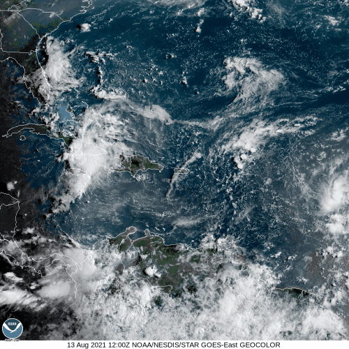
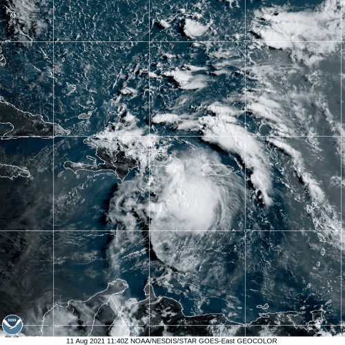
Tropical Depression Fred remains fairly weak this afternoon near the northern coast of Cuba. It’s centered about 245 miles southeast of Key West, Florida, moving toward the west-northwest at 12 mph. Maximum sustained winds are only near 35 mph. A Tropical Storm Warning is in effect for the Florida Keys, with a Tropical Storm Watch in effect for parts of southwestern Florida and northern Cuba.

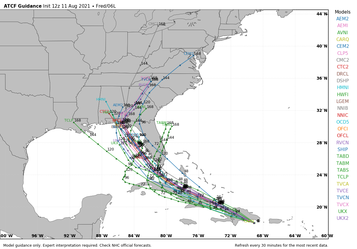
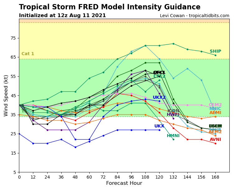
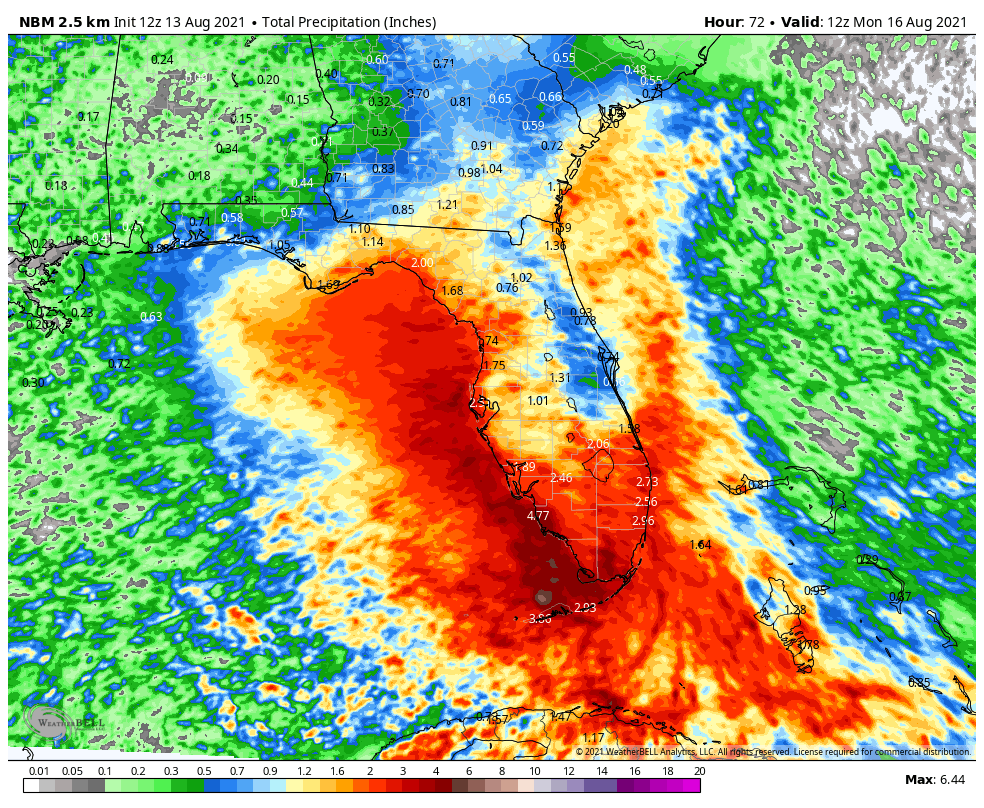
The combination of wind shear and interaction with land has kept Fred weak for the past couple of days, and that will continue for the next 12-24 hours. After that, Fred should turn more toward the northwest and eventually north, crossing the Florida Keys and moving into the eastern Gulf of Mexico. This should allow for some strengthening. Fred may regain tropical storm strength, but it does not (at least for now) look like it will become a hurricane before its eventual in the Florida Panhandle late Sunday or early Monday.

Model forecast tracks for Tropical Depression Fred. Image provided by Weathermodels.com

With a track expected to be just off the west coast of Florida, that means that much of the peninsula can expect heavy rain and some gusty winds this weekend. While winds won’t be exceptional, some gusts to 40 mph are possible, especially near the Gulf coast. Rainfall totals of 3-6 inches are expected across the region with some heavier amounts likely. Flood Watches are in effect for parts of the region. The other threat across the area will be for tornadoes. With tropical cyclones, the threat for tornadoes is highest in the right front quadrant of a storm. With a storm moving northward like this one, that means north and east of the center, which in this case will be across much of Florida.

Heavy rain will likely produce flooding in parts of Florida over the next few days. Image provided by WeatherBell.

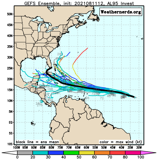
Fred isn’t the only system in the Atlantic that we’re watching right now. A disturbance centered about 775 miles east of the Leeward Islands is gradually organizing this afternoon. It doesn’t quite have a closed circulation yet, but it is expected to over the next 12-24 hours, so the National Hurricane Center has designated it “Potential Tropical Cyclone Seven”. This designation allows Tropical Storm Watches to be issued for much of the Leeward Islands. For now, it’s not really a storm, but we’ll let NHC play their games. The system is moving westward at 21 mph, and maximum sustained winds are near 35 mph.

Track forecasts from the various members of the GFS Ensemble for the disturbance east of the Leeward Islands. Image provided by Weathernerds.org

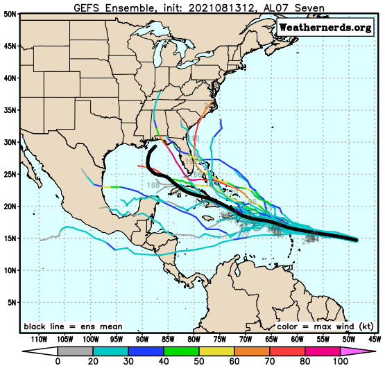
The future of this system is uncertain. Some models have it continue westward, across the Leeward Islands and into the eastern Caribbean, following a similar path to Fred, near or just south of the Virgin Islands and Puerto Rico, then across Hispaniola. This would keep the system fairly weak. Other models have it a little farther north, passing north of PR/VI and Hispaniola, and into the Bahamas. This would allow for a stronger storm. However, the storm also needs to slow down a bit, or it won’t strengthen that fast, no matter what track it takes. Either way, the system will bring heavy rain and squally conditions to the Leeward Islands on Saturday, and PR/VI through the weekend.

Model intensity forecasts for the disturbance east of the Leeward Islands. Image provided by Tropical Tidbits.

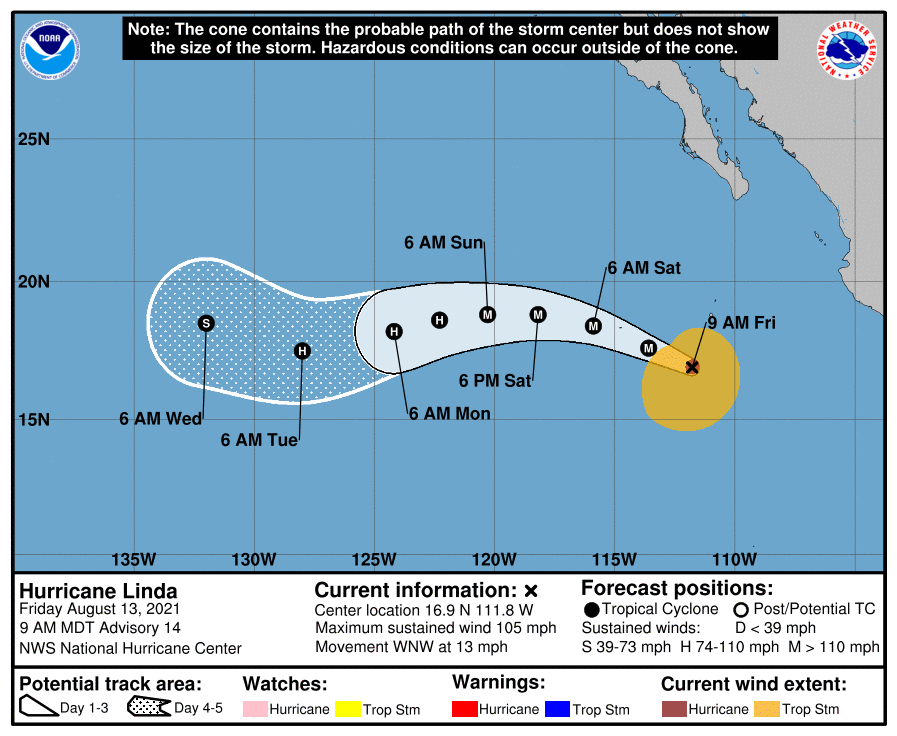
Meanwhile, in the eastern Pacific, Hurricane Linda continues to strengthen. At midday, Linda had maximum sustained winds near 105 mph, and was centered about 430 miles south-southwest of Cabo San Lucas, Mexico, moving toward the west-northwest at 13 mph. Linda may strengthen a bit more over the next day or two, becoming a Major Hurricane during that time frame. After that, it should begin to weaken. Linda will head in a general westerly direction for the next few days, likely remaining over open water. The only impact it will have is large swells moving into the west coast of Mexico, creating hazardous rip currents.

Forecast track for Hurricane Linda. Images provided by the National Hurricane Center.

Out in the Western Pacific, Tropical Storm 16W is starting to gather strength. The system is centered about 235 miles east-northeast of Enewetak, where a Tropical Storm Watch is in effect. It is moving toward the west at 14 mph, with maximum sustained winds near 40 mph. It is expected to maintain its current strength through the weekend while heading westward. It may start to strengthen by the end of the weekend, and could become a threat to parts of the Northern Mariana Islands by early next week.

Forecast track for Tropical Storm 16W. Image provided by the National Weather Service office in Guam.

Elsewhere, the tropics remain quiet for now, but that likely won’t last too long as we are rapidly approaching the peak of hurricane season in both the Atlantic and the Pacific.

Finally – Fred Forms, Florida Fears?

After bringing heavy rain and gusty winds to parts of the northeastern Caribbean for a couple of days, a tropical disturbance finally closed off its circulation late last night to earn the designation Tropical Storm Fred.

Satellite loop of Tropical Storm Fred. Loop provided by NOAA.

As of early Wednesday afternoon, Tropical Storm Fred was centered about 30 miles west of Santo Domingo, Dominican Republic, moving toward the west-northwest at 16 mph. Maximum sustained winds were near 45 mph. A Tropical Storm Warning remains in effect for much of the Dominican Republic, with Tropical Storm Watches in effect for parts of Haiti, eastern Cuba, the Turks and Caicos Islands, and the southeastern Bahamas.

The combination of the center crossing the mountainous terrain of Hispaniola and westerly wind shear will keep Fred weak for the next day or two as it heads west-northwestward across Haiti and near the coast of Cuba. Whether the center stays offshore of Cuba or near or just onshore will have an impact on how much the storm starts to re-strengthen. It will produce gusty winds and heavy rain across Hispaniola, eastern Cuba and parts of the Bahamas, leading to flooding and mudslides. Rainfall totals of 3-6 inches and locally heavier are likely.

Model forecasts for the track of Tropical Storm Fred. Image provided by WeatherBell.

By late Friday or Saturday, Fred will start to turn more toward the northwest and north as it rounds the edge of a large ridge of high pressure over the Atlantic. This should bring the storm across the Florida Keys early Saturday, and then into the eastern Gulf of Mexico. It should start to strengthen again as it heads toward the northern Gulf Coast. The current forecast from the National Hurricane Center calls for Fred to make landfall in the Florida Panhandle early Monday as a strong tropical storm. However, given the average errors in forecasting tropical systems, it could be a hurricane by then. Landfall could also take place as far west as Louisiana, or the system could turn earlier and impact southern or even southeastern Florida. A lot of these variables should become a bit clearer once Fred emerges from Hispaniola early Thursday. It does seem likely that heavy rain will impact at least parts of southern Florida this weekend, with flooding likely. Tropical Storm Watches will likely be issued for at least the Florida Keys, if not parts of southern Florida as well, late tonight or early Thursday.

Model forecast for the intensity of Tropical Storm Fred. Image provided by Tropical Tidbits.

Fred might be the only named system in the Atlantic right now, but it’s not the only system we’re keeping an eye on. There’s a tropical wave several hundred miles west-southwest of the Cabo Verde Islands. That wave will make its way across the Atlantic over the next several days. It is disorganized at the moment, but conditions should become more favorable for development over the next few days. Some models show to potential for it to become a tropical depression as it nears the Lesser Antilles this weekend. We’ll watch this one over the next few days as it continues its trek westward.

Forecast tracks for the disturbance in the central Atlantic from the various members of the GFS Ensemble. Image provided by Weathernerds.org.

The Atlantic isn’t the only active basin at the moment. In the Eastern Pacific, Tropical Storm Kevin is a few hundred miles west-southwest of Baja California, but it is expected to dissipate over open water in the next few days. We also have Tropical Storm Linda, located a few hundred miles off the southwest coast of Mexico. Linda is expected to become a hurricane tonight or Thursday, but will head west-northwestward away from land for the next several days. In the Western Pacific, Tropical Depression 16W is located just west of the International Dateline, but should remain fairly weak as it heads westward over the next few days. It could impact a few islands, such as Enewetak, with squally conditions over the next few days, but in general, it isn’t much of a threat.

Weekend Outlook: August 6-9, 2021

After a good soaking this morning, drier air is on the way, but the weekend won’t be completely dry.

Much of Rhode Island and Southeastern Massachusetts received 2-4 inches of rain in the past 24 hours. Image provided by NOAA.

High pressure starts to build into the region tonight, with skies clearing out by Friday morning across much of the region. This sets up a rather nice day on Friday with sunshine and warmer temperatures. A good chunk of Saturday looks decent too, but an approaching disturbance will spread clouds in, with some showers possible at night and into parts of Sunday as it moves through. Sunday won’t be a washout, but it will be cloudy and a little cooler with some showers around. High pressure builds back in on Monday with some sunshine returning.

Saturday looks quite warm across the area. Image provided by WeatherNBell.

Thursday night: Gradual clearing. Low 58-65.

Friday: Sunshine and a few afternoon clouds. High 80-87. Offshore: Southwest winds 5-10 knots, seas 3-6 feet.

Friday night: Partly cloudy. Low 61-68.

Saturday: Thickening clouds. High 82-89. Offshore: Southwest winds 5-15 knots, seas 2-4 feet.

Saturday night: Mostly cloudy with a few showers possible. Low 63-70.

Sunday: Plenty of clouds with some showers around. High 77-84. Offshore: Southwest winds 5-10 knots, seas 2-4 feet.

Sunday night: Any lingering showers end in the evening, then becoming partly cloudy to clear. Low 61-68.

Monday: A mix of sun and clouds. High 75-82. Offshore: Southeast winds 5-10 knots, seas 2-4 feet.

The Atlantic is starting to wake up once again. Image provided by the National Hurricane Center.

Finally, we’ll touch on the tropics, since we’re into August, which is when activity usually starts to ramp up, and this year is no different. There are two areas being watched in the Atlantic right now. The first wave will bring some showers and breezy conditions to the Caribbean this weekend and early next week, but shouldn’t amount to much. It’s the wave that is just moving off of Africa that bears watching. Some of the models show that system developing over the next several days. Obviously it’s WAAAAAAY to early to determine if it will become anything or impact any land, but these waves will become more common over the next several weeks, with many storms expected to form. Colorado State University issued their updated hurricane season forecast this morning, and they are expecting another 13 named storms this season. Late August and most of September is when we especially need to be alert up here. Of the 18 hurricanes that made landfall in New England or Long Island since 1851, 15 of them have done so between August 19 and September 27.

Weekend Outlook: July 9-12, 2021

We’re not sure if you’ve heard, but Tropical Storm Elsa is heading this way. It have have some impacts around here tonight and Friday.

Flash Flood Watches are in effect for much of the Northeast, with Tropical Storm Warnings along the coast. Image provided by Pivotal Weather.

As of 2pm EDT, Elsa was centered about 25 miles southwest of Raleigh, NC and moving toward the northeast at 20 mph. Maximum sustained winds are down to 45 mph. A Tropical Storm Warning is in effect for the coast of Connecticut from New Haven eastward, coastal Rhode Island, and nearly all of the coast of Massachusetts from the Mouth of the Merrimack River southward (sorry Salisbury, you don’t get to play), including Cape Cod and the Islands. Elsa will continue northeastward tonight, turning more toward the east-northeast on Friday, likely passing right across southeastern Massachusetts.

Winds may gust to 40 mph or more across parts of RI and southeastern MA on Friday. Image provided by WeatherBell.

Tropical systems have different characteristics when they get up this way, compared to how they look in the Caribbean or Gulf of Mexico. They take on a “rain to the left, wind to the right” appearance. This means that the heavy rain shifts to the left side of the storms track, while most of the strong winds are to the right of the track. In this case, that means most of the wind will be confined to parts of southern RI, southeastern MA, and the offshore waters, but much of the rest of the region can expect heavy rain. How much rain? Rainfall totals of 2-4 inches and possibly heavier, most of it falling between about 8am and 2pm on Friday. Oh, an just to add to the fun for the folks in southern RI and southeastern MA, these systems can and usually do produce some short-lived weak tornadoes, mainly in the right-front quadrant of the storm.

Elsa will produce heavy rain, especially north and west of I-95. Image provided by Weathermodels.com

Before Elsa gets here, we’ll have some showers and thunderstorms to deal with this evening and tonight, thanks to a stalled out frontal system draped across the South Coast. Once Elsa’s rain moves out late Friday, high pressure will try to build back in on Saturday, but we’ll still have plenty of moisture around, which means we could pop a few showers and thunderstorms Saturday afternoon. Warm and humid air moves back in for Sunday and Monday (and into the middle of next week), with some showers and thunderstorms possible each afternoon, especially Monday.

Thursday night: Cloudy with showers and thunderstorms during the evening. Rain and showers redevelop late at night. Low 60-67, a little warmer along the South Coast.

Friday: Windy with rain, heavy at times, tapering off in the afternoon. High 72-79. Offshore: East Coast Southeast 15-25 knots, gusts to 40 knots, becoming northwest late in the day, seas 3-6 feet. South Coast: Southeast to south winds 20-40 knots, gusts to 50 knots, seas 6-10 feet.

Friday night: Showers end in the evening, then becoming partly cloudy. Low 62-69.

Saturday: Partly sunny, chance for an afternoon shower or thunderstorm. High 73-80. Offshore: West to northwest 5-10 knots, seas 3-6 feet.

Saturday night: Clear to partly cloudy. Low 59-66.

Sunday: Intervals of clouds and sunshine, a shower or thunderstorm is possible during the afternoon. High 75-82. Offshore: East to southeast winds 5-10 knots, seas 2-4 feet.

Sunday night: Partly to mostly cloudy. Low 61-68.

Monday: Partly sunny, chance for a few afternoon showers or thunderstorms. High 77-84. Offshore: South winds 5-10 knots, seas 2-4 feet.

Elsa Makes Landfall, What’s Next?

After bringing heavy rain and gusty winds to portions of the Caribbean and Florida over the past several days, Tropical Storm Elsa made landfall in northwestern Florida this morning. It’s not done yet though, not by a longshot.

Radar loop of Elsa making landfall Wednesday morning. Loop provided by Weathermodels.com

As of 2pm EDT, Tropical Storm Elsa was centered about 105 miles west of Jacksonville, Florida, moving toward the north at 14 mph. Maximum sustained winds have decreased to near 50 mph. Tropical Storm Warnings remain in effect for part of northwestern Florida, and for the Atlantic coast of Georgia and South Carolina. A Tropical Storm Watch is in effect north of there all the way up to northeastern New Jersey.

Model forecasts for the track of Elsa. Image provided by Tropical Tidbits.

The forecast for the next 36 hours is fairly straightforward. Elsa will turn northeastward, moving across parts of Georgia, the Carolinas, and into Virginia while gradually weakening. Gusty winds, and heavy rain are likely, with rainfall totals of 3-5 inches and locally heavier likely producing flooding in many areas. In addition, to the east of the storm’s center, some tornadoes are also possible.

Once it gets into the Mid-Atlantic states later Thursday, we have a bit of uncertainty in the forecast. Elsa will continue northeastward, and may start to become extratropical. When this happens, the stronger winds cover a larger area, compared to tropical systems, where the strongest winds are found very close to the center. Many models show Elsa starting to strengthen a bit again. This is likely when it is starting to become extratropical. Elsa may move back over water south of Long Island, but that will depend on when it begins to turn more toward the east-northeast. This has implications for Southern New England.

Elsa will produce heavy rain up and down the East Coast over the next few days. Image provided by WeatherBell.

Elsa will continue to produce heavy rain and gusty winds across the Mid-Atlantic states and into Southern New England later Thursday into Friday. However, the strongest winds are found to the right of the center. If the storm passes near or just south of New England, that means that the strongest winds will stay offshore, possibly impacting Cape Cod and the Islands. However, if the storm stays inland, and moves across Southern New England, then a period of strong to damaging winds could impact parts of Connecticut, Rhode Island, and Southeastern Massachusetts on Friday. Sustained winds of 20-30 mph, with gusts of 50-60 mph would be possible. A track even farther to the west (which is possible), could result in those strong winds impacting the New York City, Providence, and Boston metropolitan areas on Friday.

Where will Elsa track in relation to southern New England? Images provided by Pivotal Weather.

Conditions will improve across New England on Saturday as Elsa (or what’s left of it) moves into Atlantic Canada, and beyond that, the Atlantic looks quiet for a while, which is fairly typical for early July. Plumes of Saharan Dust are making their way across the Atlantic and into the Caribbean, which suppresses tropical activity.

Elsa Heads Toward Cuba, Florida

Tropical Storm Elsa has its sights set on Cuba and Florida over the next couple of days.

Radar from Cuba shows Elsa bringing heavy rain to Jamaica and parts of Cuba. Image provided by Brian McNoldy, Univ. of Miami, Rosenstiel School.

After weakening to a Tropical Storm, Elsa has been battering parts of the Dominican Republic, Haiti, and Jamaica with strong winds and heavy rainfall over the past couple of days. Cuba is starting to feel the effects, and they’ll become more widespread today and Monday. Tropical Storm Watches and Warnings are in effect for Jamaica, most of Cuba, parts of the Cayman Islands, as well as the Florida Keys and parts of South Florida.

Tropical Storm Watches and Warnings are in effect for parts of the Western Caribbean and South Florida. Image provided by the National Hurricane Center.

As of midday Sunday, Elsa was centered about 50 miles north of Kingston, Jamaica, moving toward the west-northwest at 13 mph. Maximum sustained winds were near 60 mph. While the storm may strengthen a little today, weakening is expected tonight as the center crosses Cuba. Once it reemerges in the Florida Straits on Monday, it will head northward toward the Florida Keys. While the water is plenty warm enough to support some intensification, shear will begin to increase as well, which acts to weaken the storm. The current forecast calls for the system to maintain its intensity Monday and Tuesday. Since intensity is usually the hardest thing to forecast in tropical systems, we wouldn’t be surprised if it re-intensified back into a hurricane, nor would we be surprised if it continued to weaken as it is moving northward off the west coast of Florida.

Some models show Elsa intensifying again after crossing Cuba, others don’t. Image provided by Tropical Tidbits.

Once Elsa crosses the Florida Keys it will continue northward, eventually turning northeastward as it moves around the edge of a large ridge of high pressure centered over the western Atlantic. When it starts making that northeast turn will determine where landfall is expected in Florida. At this point, anywhere from Fort Myers to Pensacola could be the spot. Either way, heavy rain is likely across Florida over the next couple of days, especially western Florida. Rainfall totals of 4-8 inches and locally heavier will result in flooding in some areas.

Model forecasts for the track of Tropical Storm Elsa. Image provided by Weathermodels.com

Once it makes the turn, we have another question that we can’t answer yet – when will the center re-emerge over the Atlantic? Obviously, the longer it remains over land, the weaker it will be, but if it were to move offshore closer to northern Florida or Georgia instead of over North Carolina, there would be a window for a little strengthening as it moves over the warm waters of the Gulf Stream. Either way, it will bring heavy rain and gusty winds to parts of Georgia and the Carolinas toward the middle of the week. Once it moves back offshore, it should continue northeastward and out to sea while becoming extratropical later this week. Depending on how far north it actually gets, it could interact with a frontal system and bring some rainfall to parts of eastern New England by the end of the week, but there’s a lot that has to happen first before we can have any clarity on that possibility.

Hurricane Elsa Cruises Through the Caribbean

After starting hurricane season with 4 “tropical storms” that were probably not tropical, the first hurricane of the season has developed.

Hurricane Elsa formed as Tropical Depression Five late Wednesday night well east of the Lesser Antilles, and became Tropical Storm Elsa on Thursday. It rapidly intensified into a hurricane Friday morning as it approached Barbados. As Elsa crossed the Windward Islands Friday morning/early afternoon it produced wind gusts as high as 86 mph on Barbados and 79 mph on Saint Lucia. This is the earliest in the season that a storm has hit Barbados, and it is the 2nd earliest Hurricane ever in the eastern Caribbean, trailing only an unnamed storm from 1933.

Satellite loop of Hurricane Elsa. Loop provided by NOAA.

As of 2am Saturday, Hurricane Elsa was centered approximately 620 miles east-southeast of Kingston, Jamaica, moving toward the west-northwest at 29 mph. Maximum sustained winds are near 80 mph.

Hurricane Warnings are in effect for southern portions of the Dominican Republic and Haiti, as well as for the island of Jamaica, with Tropical Storm Warnings for the remainder of the Dominican Republic and Haiti. A Hurricane Watch is in effect for parts of eastern Cuba, and a Tropical Storm Watch is in effect for parts of the Cayman Islands.

Watches and Warnings associated with Hurricane Elsa. Image provided by the National Hurricane Center.

Elsa could strengthen a bit on Saturday, but for the most part, weakening is forecast. Some dry air got entrained in the circulation late Friday, okus the current rapid forward speed with both serve to inhibit any further strengthening, Although Elsa is expected to slow down over the next 24 hours, a turn more toward the northwest is expected. This will bring the storm closer to Hispaniola, where the mountainous terrain could disrupt the circulation as well.

Model forecasts for the intensity of Hurricane Elsa. Image provided by Weathermodels.com.

Current forecasts bring the center of the storm close to southern Haiti Saturday night, then toward southeastern and southern Cuba on Sunday. The intensity of the storm will be determined partially by the track the storm takes. The longer the circulation center stays over water, the better chance that the storm is stronger.

Model forecasts for the track of Hurricane Elsa. Image provided by Weathermodels.com.

As the storm slows down, it increases the chances for heavy rainfall across southern portions of Hispaniola, eastern and southern Cuba, and parts of Jamaica. Rainfall totals of 6-12 inches and locally heavier will lead to flooding and mudslides.

Elsa will bring heavy rainfall to portions of the Caribbean. Image provided by Weathermodels.com

Elsa is expected to cross Cuba on Monday while turning northward. Given that this is already three days out, the uncertainty in the forecast becomes much large. A track towards Florida seems likely, but is far from definite at this point. Several models bring the storm up the west coast of Florida, while many others bring it up the east coast or even over the Bahamas. How strong the storm is at this point is also highly uncertain. Residents from the central Gulf Coast all the way to the Carolinas should keep tabs on the system this weekend, as it has the potential to impact anywhere within that range by the early to middle portion of next week.

Forecasts for Elsa’s track from the 51 members of the ECMWF Ensemble. Image provided by Weatehrnerds.org

Elsewhere, the tropics remain fairly quiet, with no other organized systems at this time.

Weekend Outlook: June 18-21, 2021

Summer officially starts Sunday night, but the last weekend of Spring is looking pretty good for the most part.

Aside from some pop-up cumulus, it’s a picture-perfect day across the region. Loop provided by the College of DuPage.

High pressure remains in control into Friday with more sunshine and warm temperatures as the high slides offshore. Humidity levels may start to creep up a bit on Friday, but it will still be comfortable. Low pressure will be heading into southern Canada later on Friday, and it will send a warm front our way at night. As that front moves through early Saturday morning, it may produce a few showers or thunderstorms. Not a big deal, and they should be done before most of you have finished your breakfast (or even gotten out of bed). Some sunshine may break out in the afternoon, and it will be quite warm and humid. A cold front will sweep across the region during the afternoon and evening. That front will produce another round of showers and thunderstorms. Depending on the timing of the front, some of those storms could become strong to possibly even severe. Don’t go cancelling any late-afternoon or evening plans, but if you’ll be outside, keep an eye to the sky.

High pressure builds back in on Sunday for the final day of Spring (the Summer Solstice occurs at 11:31pm Sunday night) with lower humidity, but it will remain quite warm. Humidity levels and temperatures will creep back up on Monday ahead of the next frontal system. Any shower or thunderstorm activity with this system should hold off until after dark.

We’ll give a quick mention about the tropics here as well. There are no active systems at this time, but there is a cluster of thunderstorms in the western Gulf of Mexico that is being monitored. It will likely become a tropical depression, possibly as early as tonight, then head northward. It should bring some heavy rain to parts of the Gulf Coast and Deep South this weekend. The National Hurricane Center is going to start issuing advisories on “Potential Tropical Cyclone Three” at 5pm EDT. We’ll likely write a blog post about the system either late tonight or tomorrow, once it actually becomes a tropical depression or tropical storm. Beyond that, some of the moisture from this system could interact with the cold front approaching us Monday night, but it’s still a little early to determine if that will happen or not. We’ll have a better idea by the time we issue our Weekly Outlook early Monday morning.

Satellite loop of the Gulf of Mexico where a tropical depression will likely develop tonight or tomorrow. Loop provided by NOAA.

Thursday night: Clear skies. Low 48-55.

Friday: Morning sunshine starts to fade behind increasing late-day clouds. High 77-84. Offshore: Southwest to south winds 10-15 knots, seas 2-4 feet.

Friday night: Mostly cloudy, chance for a few showers or thunderstorms late at night. Low 59-66.

Saturday: A few early showers, then becoming partly sunny. Another round of showers and thunderstorms is possible late in the day. High 80-87. Offshore: Southwest to south winds 10-20 knots, seas 3-6 feet.

Saturday night: Showers and storms end in the evening followed by clearing. Low 58-65.

Sunday: Sunshine and some afternoon clouds. High 81-88. Offshore: Southwest to south winds 10-15 knots, seas 2-4 feet.

Sunday night: Clear during the evening, clouds start to filter in late at night. Low 59-66.

Monday: Partly sunny. High 85-92, cooler along the South Coast. Offshore: South winds 10-15 knots, seas 2-4 feet.

The Atlantic Awakens

We’re only two weeks into Hurricane Season, and the peak of the season is still three months away, but activity is starting to ramp up in the Atlantic, as another cluster of thunderstorms has received a name.

Satellite loop of Tropical Storm Bill from late Monday afternoon. Loop provided by NOAA.

In our Weekly Outlook early this morning, we mentioned an area of thunderstorms off the North Carolina coast that was disorganized. We also said that given NHC’s history, we fully expected it to be classified as a short-lived tropical depression or storm, even though it really wasn’t one. Well, as expected, the National Thunderstorm Naming Hurricane Center decided that even though there wasn’t much thunderstorm activity along a stationary from Monday morning, it was good enough for them to call it Tropical Depression Two. As of 11pm Monday, it had strengthened into “Tropical Storm Bill”, and was centered about 335 miles east-northeast of Cape Hatteras, NC, moving toward the northeast at 23 mph. Maximum sustained winds were near 45 mph. The system remains weak, and there is not a lot of thunderstorm activity with it at the moment, but it is moving over the warm waters of the Gulf Stream, so there is a small window for the system to intensify over the next 12 hours. After that, it will be moving over colder water, and will weaken before bringing some gusty winds and rainfall to parts of Newfoundland and possibly Nova Scotia tonight and Wednesday.

In the eastern Atlantic, a strong tropical wave has moved off the west coast of Africa, passing south of the Cabo Verde Islands tonight. While this system may develop a little over the next day or two, the combination of unfavorable upper-level winds and dry air will limit any development once the system reaches the central Atlantic Ocean. Once we get a little deeper into hurricane season, conditions should become more favorable as more and more waves roll off of Africa and cross the Atlantic. Some of these storms historically have become powerful systems, as they have plenty of time to develop over open water. We usually need to start paying attention to this region once we get into July.

Saharan dust crossing the Atlantic will limit any storm development. Loop provided by Weathermodels.com

The system that bears watching is in the Bay of Campeche. A cluster of showers and thunderstorms continues to meander around associated with a broad area of low pressure. While this will produce some heavy rain across parts of Mexico and Central America, it is not expected to develop over the next few days. By late in the week however, the system will start drifting northward, and conditions will become more favorable for development. It could become a tropical depression by the weekend, then it may head toward Louisiana or Texas.

Satellite loop of the Gulf of Mexico, including the Bay of Campeche. Loop provided by NOAA.

While it’s still a little early to speculate on any potential track or strength for this system, most of the models are in agreement that most of the rain from this system will head towards Louisiana. Much of southern Louisiana and Mississippi has received 30 to 45 inches of rain over the past 90 days, which is more than twice the normal amount they receive in that time frame. This has led to widespread flooding in areas still attempting to recover from several direct hits during the 2020 hurricane season. A tropical system, even a weak one, could drop 10 or more inches of rain on this area, leading to even more flooding.

Much of the Lower Mississippi Valley has been deluged with more than 30 inches of rain over the past 90 days. Image provided by WeatherBell.

Elsewhere, the only other active system in the tropics is Tropical Depression Carlos in the Eastern Pacific, but it is expected to dissipate on Tuesday over open water.

Hurricane Season Has Arrived

Earlier this month, Tropical Storm Ana brought some breezy and damp conditions to Bermuda, marking the 7th year in a row that we had at least one named tropical system in the Atlantic before the “official” start of Hurricane Season, which runs from June 1 through November 30. After a record-setting hurricane season in 2020, it looks like another busy season lies ahead.

The list of Hurricane names for the 2021 season. Image provided by NOAA.

While we might quibble with some of the systems that got named last year, there was no denying the fact that it was a very active season. We had a total of 30 named storms, which set a record. Of those 30, 13 became hurricanes, and 7 were major hurricanes. The seven major hurricanes tied 2005 for the most in a single season. We also had a record 12 storms make landfall in the United States, including FIVE in Louisiana alone.

The 2020 Hurricane Season was a record-setting one across the Atlantic Basin. Image provided by the National Hurricane Center.

An early start is not always a harbinger of what the season will bring. NOAA issued their seasonal hurricane outlook on May 20, and it calls for a 60 percent chance for an above normal season, a 30 percent chance for a normal season, and a 10 percent chance for a below normal season. Many of the other hurricane outlooks issued by various outlets are also expecting a busy season, due to a number of factors. An average season consists of 14 named storms, of which 7 become hurricanes and 3 become major hurricanes (Category 3 or higher on the Saffir-Simpson scale). NOAA’s forecast for this season calls for 13-20 named storms, 6-10 hurricanes, and 3-5 major hurricanes. The Tropical Meteorology Project at Colorado State, the first group to forecast how active a hurricane season would be, originally led by Dr. Bill Gray, will issue their forecast on June 3. Their initial forecast from April called for 17 named storms, 8 hurricanes, and 4 major hurricanes. They also pegged the chance at a storm making landfall in the United States at 69% (52% is the average in any given year), and the odds of a storm making landfall along the East Coast at 45% (31% is the average). The last 6 seasons have all featured above normal activity across the Atlantic.

Despite the early start for the past several years, the average date for the first named storm in the Atlantic is still in late June or early July. Over 97% of all named storms in the Atlantic form between June 1 and November 30. Like our first storm this year, most early season storms tend to be on the weaker side. A hurricane hasn’t made landfall in the United States before July 1 since Hurricane Bonnie came ashore as a minimal hurricane near the Texas/Louisiana border on June 26, 1986.

Based on climatology, the most likely spots for an early season storm are in the Gulf of Mexico or northwest Caribbean. Image provided by the National Hurricane Center.

A busy season does not always mean that multiple storms (or any storms for that matter) will impact the United States, though last year saw much of the Gulf Coast and East Coast threatened by tropical systems. In 2010, 19 named storms were observed in the Atlantic, 12 of them became hurricanes, and 5 were major hurricanes. Only one storm made landfall in the United States, and that was Bonnie, which was a minimal tropical storm at landfall. In 1990, there were a total 14 named storms, 8 of them hurricanes and 1 major hurricane. Not a single one of them made landfall in the United States. On the flip side, an inactive year doesn’t mean much for landfall probabilities as well. Only 7 named storms formed in 1992, and the 1st one didn’t develop until August 16. That storm, however, was named Andrew, and it made landfall just south of Miami as a category 5 storm. It only takes one storm to ruin your entire year.

Here in New England, we should always pay attention when a storm is nearing the Bahamas, as those are the ones that have the potential to impact us, and we are very overdue for a system to impact us. Using data back to 1851, here are some stats that show how overdue we are:

  • Since 1851, 36 storms of tropical storm strength of greater have made landfall in New England or Long Island, an average of one every 4.7 years. The longest we’ve ever gone without one is 11 years, between 1897 and 1908 and also between 1923 and 1934. We’re at 10 years since Irene, the last one to do so.
  • Since 1851, 29 strong tropical storms (maximum sustained winds of 60 mph or more) have made landfall in New England or Long Island, an average of one every 5.9 years. The longest we’ve ever gone without one is 19 years, between 1897 and 1916. We’re at 10 years since Irene, the last one to do so.  
  • Since 1851, a hurricane has made landfall in New England or Long Island 18 times, an average of one every 9.4 years. The longest we’ve ever gone between hurricane landfalls is 38 years, between 1896 and 1934. It’s been 30 years since Bob, our 2nd longest drought on record.
  • Since 1851, 9 hurricanes of Category 2 intensity or stronger have made landfall in New England or Long Island, an average of one every 18.9 years. The longest we’ve gone between hits by storms of that intensity is 69 years, between 1869 and 1938. We’re at 30 years since Bob, the last one to do so.
  • Since 1851, New England/Long Island has had 3 Major Hurricanes (Category 3 or higher) make landfall – an unnamed storm in October of 1869, the infamous 1938 Long Island Express, and Hurricane Carol in 1954. That’s an average of 1 every 56.7 years, and the longest time between 2 major hurricanes is 69 years (1869-1938). We’re at 67 years since Carol. There are also 3 documented storms from before 1851 – The Great Colonial Hurricane of 1635, the 1815 New England Hurricane, and the Norfolk and Long Island Hurricane of 1821. That’s it. That changes the numbers to 6 in 386 years, or one every 64.3 years, with a longest drought of 180 years.
Satellite photo of Hurricane Bob approaching New England. Bob was the last hurricane to make landfall in New England – 30 years ago. Image provided by NOAA.

We all saw what Sandy did in 2012, and that was a minimal hurricane that eventually made landfall in southern New Jersey (technically as an extratropical storm). When (not if) the next big storm comes up the coast, much of this region will not be prepared for the storm or its aftermath.

The Atlantic is quiet right now, but even if something were to form off the East Coast in the next few weeks and head this way, the waters off of New England are much too cold to sustain a tropical system, so we’d see something more like a typical nor’easter. Only two tropical storms have ever made landfall in the Northeast before the end of June. The first was an unnamed minimal tropical storm that crossed extreme eastern Long Island and went into southeastern Connecticut on May 30, 1908. The other was Tropical Storm Agnes, which made landfall near New York City on June 22, 1972, then caused devastating flooding across parts of the Mid-Atlantic states. In terms of hurricanes, the earliest one to ever make landfall up this way was Hurricane Belle, which slammed into Long Island with 90 mph winds on August 9, 1976. We did have Hurricane Arthur pass just offshore of Nantucket on July 4, 2014. While it did not make landfall, it made for a rather wet and cool holiday, especially across Cape Cod and southeastern Massachusetts. Statistically, the most likely time for a hurricane to hit New England is between the middle of August and late September. Of the 18 hurricanes that made landfall in New England or Long Island since 1851, 15 of them have done so between August 19 and September 27.

The most likely time for a tropical system to impact our area is August or September. Image provided by the National Weather Service office in Norton, MA.

As always, you should get your weather information from a trusted source, especially when dealing with tropical systems. Much like with snowstorms in the winter, there will be plenty of hype and exaggeration on Twitter and Facebook, as well as people posting doom and gloom maps showing how a thunderstorm near the coast of Africa will develop into a Category 5 storm and head right for the East Coast in the next 2 weeks. We’re not among that group, we give you facts and our best forecasts, without any hype. If there’s reason to worry, we’ll let you know with plenty of advance warning. It’s always best to prepare ahead of the season. Chances are, you won’t have anything to worry about, but in case you do, it’s always good to be prepared, as we’ve learned recently.