A Classic “Good News/Bad News” Weekend is Coming Up

Sunday isn’t looking that great around here, but things could be worse. Severe weather is likely across the Mid-Atlantic states on Sunday. Meanwhile, Tropical Storm Bonnie will head out into the open Atlantic this weekend, but another area is being watched for development near the Yucatan Peninsula.

We’re starting the weekend off with a fantastic Saturday here in New England, but big changes are coming. High pressure builds in today, so after some morning fog burns off we’ll have a mix of sunshine and clouds this afternoon. High temperatures will get into the upper 60s and 70s near the coastline, but away from the water, highs will be in the lower to middle 80s, with a few spots possibly reaching the upper 80s. Make sure you get outside and enjoy it because clouds will stream in late in the day ahead of a cold front moving across the Midwest.

Ahead of that front, with a warm, humid airmass in place, showers and thunderstorms will develop, some of which will become strong to severe. Widespread severe weather isn’t expected on Saturday, but there is a risk for some strong to severe storms from the Great Lakes into the Ohio Valley.  Sunday will be a different story. The ingredients will be in place for a severe weather outbreak from the Mid-Atlantic states into the Carolinas.

sbli.us_ma
GFS forecast of Lifted Index values for Sunday afternoon. Image provided by Pivotal Weather
sbcape.us_ma
GFS forecast of CAPE values for Sunday afternoon. Image provided by Pivotal Weather

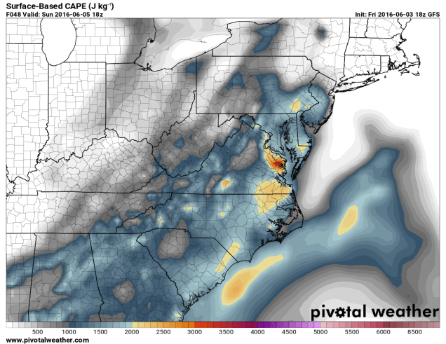
As temperatures rise into the 80s to lower 90s, the airmass will become increasingly unstable. CAPE, which is short for Convective Available Potential Energy, is a measure of instability through the atmosphere. CAPE values of 1000-3000 J/kg are expected from the Delmarva Peninsula into the Carolinas Sunday afternoon. These values are indicative of moderate instability in the atmosphere. The “Lifted Index” is the difference in temperature between the atmosphere at 500mb (about 18,000 feet up) and a parcel of air from the surface that is lifted to 500mb. A negative value is indicative of unstable conditions. On Sunday, forecast models are showing values between -4 and -9 across the Mid-Atlantic states.

While Sunday may start off cloudy with showers across parts of the region, breaks of sunshine should develop by early afternoon, with showers and thunderstorms developing along the eastern slopes of the Appalachians. Thunderstorm activity will likely organize into a line that will march eastward, reaching the Washington/Baltimore area by late afternoon, and the Richmond/Norfolk area towards evening. The main threats with any storms that do develop are strong winds, hail, and heavy downpours, with a few tornadoes also possible.

Up here in New England, we won’t have to worry too much about severe weather. That doesn’t mean we’ll have a great day. Rain will likely develop Sunday morning and continue for much of the day, ending late Sunday night or early Monday morning. We’re looking at an inch to an inch and a half of rain across the region, which we really need, as it’s been dry for the past few months. If you’ve got outdoor plans for Sunday, we’d start looking for alternate ideas. While the day may not be a complete washout, it’ll be cloudy, relatively cool (60s to lower 70s), and raining off and on for much of the day.

20160531_northeast_trd
Most recent update on drought conditions across the Northeast. Image provided by NOAA.

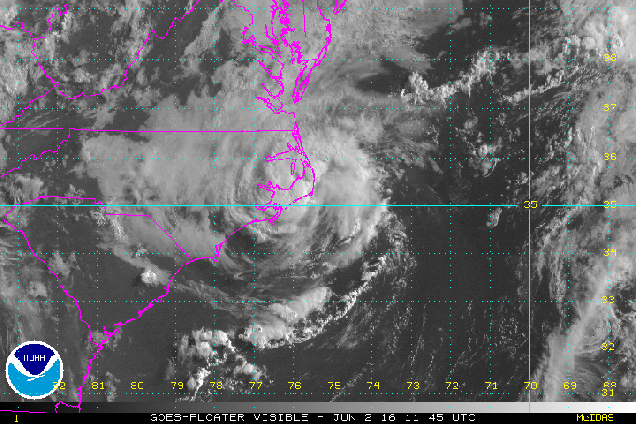
Meanwhile, Tropical Storm Bonnie has redeveloped east of North Carolina this evening. As of 5pm Friday, Bonnie was centered about 285 miles east of Cape Hatteras, NC, moving towards the east at 13 mph. Maximum sustained winds are near 40 mph. Bonnie is expected to head out into the open waters of the Atlantic over the weekend while steadily weakening.

vis_lalo-animated
Satellite loop of Tropical Storm Bonnie from Friday afternoon. Loop provided by NOAA.

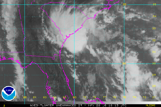
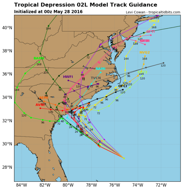
While June is usually quiet in the tropics, another area of disturbed weather in the western Caribbean is being monitored for development this weekend. A cluster of showers and thunderstorms will head towards the Yucatan Peninsula this weekend and then turn more towards the north and head into the Gulf of Mexico. For several days now, forecast models have been indicating that this system could become a tropical depression or tropical storm over the Gulf early next week.

93L_intensity_latest
Computer model forecasts for the strength of a potential tropical system in the Gulf of Mexico. Image provided by Tropical Tidbits
93L_tracks_latest
Computer model forecasts for the track of a potential tropical system in the Gulf of Mexico. Image provided by Tropical Tidbits

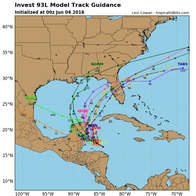
Most forecasts are for the storm to turn more toward the northeast early next week and cross the Florida Peninsula as a tropical depression or weak tropical storm. While winds aren’t expected to be strong, the main impact will be heavy rainfall. The storm could drop as much as 4-8 inches of rain on the Sunshine State next week, especially the southern half of the state. Heavy rain fell on portions of the region during May, so additional heavy rain could lead to flooding in parts of the area.

After all that, we didn’t even talk about the potential tropical system in the Eastern Pacific, the record heat in the West, the flooding in Paris and parts of western Europe, or the powerful storm impacting southeastern Australia. Yup, things are pretty busy in the weather office.

Bonnie’s Back! Will Colin Appear Soon?

Last week, a cluster of thunderstorms moved into South Carolina, dropping up to 10 inches of rain on the Southeast. The National Hurricane Center named this cluster Tropical Depression Two, and then for some inexplicable reason, started calling it Tropical Storm Bonnie. The system moved inland, dropped a bunch of rain on the region, and just meandered around the Carolinas for much of the past 4-5 days. Last night, the circulation center moved off the the North Carolina coast, and thunderstorms started to flare up near the center. This was the healthiest the system had looked since it was first “named”.

vis_lalo-animated
Bonnie actually looks like a Tropical Depression now. Loop provided by NOAA.

Once it became obvious that this system finally looked like an actual tropical depression, the Hurricane Center started issuing advisories on the storm (again). As of 11am Thursday, “Bonnie” was centered about 25 miles east-southeast of Cape Hatteras, NC, moving towards the northeast at 7mph. Maximum sustained winds are near 30 mph, and some strengthening is possible over the next day or so as the storm moves over the warm waters of the Gulf Stream. The forecast is for the system to head in a general easterly direction out into the open waters of the Atlantic, posing a threat only to the fish and boaters.

Once “Bonnie” is gone, the tropical threat doesn’t drop back to zero. Many of the computer models are showing the possibility of another system developing near the Yucatan Peninsula by early next weekend. The models start to develop this system as it heads into the Gulf of Mexico, then turns northeastward towards Florida.

The models then have the system cross Florida and move into the Atlantic, before heading out to sea. Some additional strengthening is possible once the system moves back out over water. If the system does get strong enough, it would be named Colin.

Meanwhile, in the Eastern Pacific, things have been quiet for the 1st few weeks of the season, but that appears to be changing as well. An area of thunderstorms about 950 miles south-southwest of Cabo San Lucas, Mexico has been showing signs of development for the past few days.

ir_lalo-animated
This could be the first tropical depression of the season in the Eastern Pacific. Loop provided by NOAA.

This system should continue on a general west to west-northwesterly track for the next few days. Some strengthening is expected, and the system could become a tropical depression in the next day or two. If the system does continue to strengthen into a tropical storm, it would be given the name Agatha.

Remember, this is just the start. The peak of hurricane season is still three months away.

Tropical Storm Bonnie Forms (Insert Punchline Here)

Earlier today, Tropical Depression Two “strengthened” into Tropical Storm Bonnie off the South Carolina coastline. In related news, Pablo Sandoval was overwhelmingly voted as the fan favorite on the Red Sox. In other words, “Bonnie” is in all likelihood NOT a tropical storm.

ir_lalo-animated
See if you can find the “center” of Tropical Storm Bonnie. (Hint: It’s not under the thunderstorms, like you would normally expect). Loop provided by NOAA.

For now, we’ll play along and pass along the details of the storm. As of 8pm EDT, TD 2, er, Tropical Storm Bonnie was centered about 135 miles south-southeast of Charleston, South Carolina and was stationary. Maximum sustained winds (likely found in one thunderstorm somewhere in the vicinity of the storm) are near 40 mph. A Tropical Storm Warning remains in effect for the coast of South Carolina from Savannah River to Little River Inlet. The official forecast from the National Hurricane Center calls for some additional strengthening before the storm makes landfall in South Carolina on Sunday.

On Sunday “Bonnie” moves inland, weakens, and dissipates. End of story, right? Not for those of us in New England. Even though “Bonnie”doesn’t look like much, it will have a big impact on our Memorial Day weather. A backdoor cold front will move across the region early Sunday, bringing an end to the heat we’ve had for the past few days. High temperatures on Sunday will be 15-25 degrees colder than Saturday, with coastal areas staying in the 60s, while inland locations reach the 70s. You’ll need to head to the Connecticut Valley to find readings in the 80s. The cooler conditions will be accompanied by clouds and a few showers.

gfs_t2max_boston_6
High temperature forecast for Sunday from the GFS. Image provided by WeatherBell.

For Memorial Day, things aren’t looking pretty. With the jet stream configured in a pattern that basically goes from south to north along the East Coast, the moisture from “Bonnie” will head right up the coastline, and into New England for Monday. That means that we’re in for a good slug of rainfall for Monday, especially during the morning hours. The Spring has been really dry, so we definitely need the rain, but unfortunately, it has to fall on Memorial Day. If you made plans to head to the beach or grill up some burgers and dogs, start looking for alternate ideas. It’s going to be cloudy, wet, and only in the 60s to lower 70s for high temperatures.

wpc_24hr_precip_boston_7
Rainfall forecast for Monday. Image provided by WeatherBell.

At least most of next week looks dry and warm with high pressure in control. So, we’ve got that going for us.

Tropical Depression Two Forms – Will it Ruin Memorial Day Plans?

The second tropical depression of the 2016 Hurricane Season has developed in the Western Atlantic Ocean.

As of 8pm EDT Friday, Tropical Depression Two was centered approximately 400 miles southeast of Charleston, South Carolina, and was moving towards the west-northwest at 13 mph. Maximum sustained winds are near 35 mph, and additional strengthening is expected.

ir-animated
Infrared satellite loop of Tropical Depression Two. Loop provided by NOAA.

The storm is expected to continue on a general west-northwest track into Saturday, with some modest strengthening possible. If the system attains maximum sustained winds of 39 mph or more, it would be named Tropical Storm Bonnie. This may occur on Saturday. However, many of the forecast models are indicating that the system may not strengthen much over the next few days, due to a combination of, wind shear aloft, and sea surface temperatures that are only marginally warm enough to sustain a tropical cyclone. Most of these models do show a track towards South Carolina over the next 24-48 hours.

02L_intensity_latest
Model forecasts for the strength of Tropical Depression Two. Image provided by tropicaltidbits.com
02L_tracks_latest
Model forecasts for the track of Tropical Depression Two. Image provided by tropicaltidbits.com

As the storm nears the coastline it will start to slow down as the upper-level steering currents start to weaken. A turn towards the north is possible, but if the turn occurs too early, it would prevent the storm from making landfall in South Carolina, but would make a landfall in southeastern North Carolina a bit more likely. Residents along the coast from Georgia to North Carolina should keep an eye on the storm’s progress, as it will likely have a significant impact on the holiday weekend forecast.

The storm will also have an indirect impact on the weekend forecast for much of the remainder of the East Coast. As the upper-level flow becomes south-to-north along the East Coast, it will take moisture from the storm and send it northward, ahead of a cold front. This will result in periods of heavy rain for the Mid-Atlantic states later on Sunday, and the Northeast on Monday. Rainfall totals of 1-2 inches or more are expected, and while it will ruin plans for barbecues and beach days, the region has not received much rain this Spring, so any moisture that does fall is needed.

qpf_048h.us_ma
Rainfall forecast from the GFS model for Sunday and Monday Image provided by Pivotal Weather

So, should you cancel your Memorial Day plans? Things can obviously change, but we’d have a backup plan ready. Right now, much of the day looks to be a washout, especially the morning and early afternoon, with temperatures only in the 60s to lower 70s. The rest of the holiday weekend looks great though. Saturday will feature a mix of sunshine and clouds, with a few popup showers and thunderstorms in the afternoon. High temperatures will be in the 80s to lower 90s, with some cooler readings right along the coastline. For Sunday, a backdoor cold front will move in, with more cloud cover, though still some sunny breaks. High temperatures will only be in the 60s to lower 70s along the coast, but inland, temperatures should reach well into the 70s, with some lower 80s well inland.

Hurricane Season is Nearly Here

June is a little more than a week away, and while that marks the start of meteorological summer, it also marks the start of Hurricane season in the Atlantic Basin (North Atlantic Ocean, Caribbean Sea, and Gulf of Mexico).

Hurricane season in the Atlantic runs from June 1 through November 30, but it got off to an extraordinarily early start in 2016 when Hurricane Alex formed back in January. Alex became the first January tropical system in the Atlantic when it acquired subtropical characteristics south of the Azores on January 13. It became a full-fledged hurricane on January 14, the first January hurricane in the Atlantic since Alice in 1955. Alex crossed the Azores as a strong tropical storm on January 15, and eventually headed out in the open Atlantic, transitioning to an extratropical cyclone on January 17. The next storm that forms will be given the name Bonnie.

050715-cc-weather-hurricanes-future-atl-2016.jpg
Name list and pronunciation guide for the 2016 Atlantic Hurricane Season

Is the early start a harbinger for an active hurricane season? Not necessarily. What will be more of a factor is the developing La Nina in the Pacific Ocean. In an El Nino, such as the one we had in 2015, the subtropical jet stream is stronger, which inhibits storm development as the jet stream effectively cuts the tops off of storms before they can develop. In a La Nina, the subtropical jet is weaker, allowing easterly winds to dominate, which allows the storms to develop.

tracks-at-2015
Map showing all tropical systems across the Atlantic Basin from the 2015 Hurricane Season. Image provided by the National Hurricane Center.

The presence of El Nino or La Nina is just one of many factors that go into whether a hurricane season is active or quiet, but most predictions are for a more active season than 2015, and above normal. In a normal season, the Atlantic Basin sees 12 named storms, of which 6 become hurricanes and 3 become major hurricanes (Category 3 or higher on the Saffir-Simpson Scale). While there are plenty of hurricane forecasts out there, these were pioneered by Dr. William Gray, who recently passed away after over 50 years in the field. His research team at Colorado State University continues his work, and for this season is calling for 14 named storms, of which 8 could become hurricanes, and 3 major hurricanes.

An active season doesn’t guarantee that a storm will make landfall in the United States though. In 2010, there were 19 named storms, 12 hurricanes, and 5 major hurricanes. Only 1 storm, Tropical Storm Bonnie, made landfall in the United States. On the flip side, 1992 was a quiet season, with just 7 named storms, 4 hurricanes, and 1 major hurricane, with the first named storm not forming until August 16. Of course, that first storm was Andrew, which slammed into South Florida on August 24 as a Category 5 hurricane, one of just 3 Category 5 storms to ever make landfall in the United States.

The peak of the season usually occurs from mid-August through late September, but an early start isn’t unusual. On average, the first named storm of the season occurs on July 9, with the first hurricane forming around August 10. In 2015, there were two tropical storms during May and June (Ana and Bill), while 2012 saw 4 named systems (Alberto, Beryl, Chris, and Debby) with 1 hurricane (Chris) forming before the end of June.

Here in New England, we should always pay attention when a storm is nearing the Bahamas, as those are the ones that have the potential to impact us. On average, a tropical storm makes landfall in Southern New England or Long Island once every 4 years, while a hurricane makes landfall once every 8 years. The last tropical storm to make landfall was Irene, which passed right over New York City in 2011, so we’re about due for another one. As for hurricanes, while we’ve been threatened several times in the past few years, the last one to make landfall was Hurricane Bob in 1991. That 25-year gap is the 2nd longest on record (dating back to 1851), second only to the 28 year gap between 1896 and 1924. In other words, we are very overdue.

hurricane_bob
Hurricane Bob approaching Southern New England. Image courtesy of NOAA

So, is anything imminent? No, and even if something were to form soon and head this way, the waters off of New England are too cold to sustain a tropical system, so we’d see something more like a typical nor’easter. Only two tropical storms have ever made landfall in the Northeast before the end of June. The first was an unnamed minimal tropical storm that crossed Long Island and went into southern Connecticut on May 30,1908. The other was Tropical Storm Agnes, which made landfall near New York City on on June 22, 1972, then caused devastating flooding across parts of the Mid-Atlantic states. In terms of hurricanes, the earliest one to ever make landfall up this way was Hurricane Belle, which slammed into Long Island with 90 mph winds on August 9, 1976. Statistically, the most likely time for a hurricane to hit New England is between the middle of August and late September. Of the 23 hurricanes that made landfall in New England or Long Island since 1851, 20 of them have done so between August 19 and September 27.