Last week, a cluster of thunderstorms moved into South Carolina, dropping up to 10 inches of rain on the Southeast. The National Hurricane Center named this cluster Tropical Depression Two, and then for some inexplicable reason, started calling it Tropical Storm Bonnie. The system moved inland, dropped a bunch of rain on the region, and just meandered around the Carolinas for much of the past 4-5 days. Last night, the circulation center moved off the the North Carolina coast, and thunderstorms started to flare up near the center. This was the healthiest the system had looked since it was first “named”.
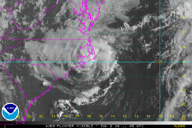
Once it became obvious that this system finally looked like an actual tropical depression, the Hurricane Center started issuing advisories on the storm (again). As of 11am Thursday, “Bonnie” was centered about 25 miles east-southeast of Cape Hatteras, NC, moving towards the northeast at 7mph. Maximum sustained winds are near 30 mph, and some strengthening is possible over the next day or so as the storm moves over the warm waters of the Gulf Stream. The forecast is for the system to head in a general easterly direction out into the open waters of the Atlantic, posing a threat only to the fish and boaters.
Once “Bonnie” is gone, the tropical threat doesn’t drop back to zero. Many of the computer models are showing the possibility of another system developing near the Yucatan Peninsula by early next weekend. The models start to develop this system as it heads into the Gulf of Mexico, then turns northeastward towards Florida.


The models then have the system cross Florida and move into the Atlantic, before heading out to sea. Some additional strengthening is possible once the system moves back out over water. If the system does get strong enough, it would be named Colin.
Meanwhile, in the Eastern Pacific, things have been quiet for the 1st few weeks of the season, but that appears to be changing as well. An area of thunderstorms about 950 miles south-southwest of Cabo San Lucas, Mexico has been showing signs of development for the past few days.

This system should continue on a general west to west-northwesterly track for the next few days. Some strengthening is expected, and the system could become a tropical depression in the next day or two. If the system does continue to strengthen into a tropical storm, it would be given the name Agatha.
Remember, this is just the start. The peak of hurricane season is still three months away.
