It seems as though we are getting a snowstorm after all tomorrow. It won’t be a big one, or a long-duration one, but it will impact your Sunday.
At the end of our Weekend Outlook, we mentioned the chance for snow on Sunday, but closed with this:
“Overall, not a big deal for most of us. Parts of the South Coast could see a few inches of snow depending on how far north the ocean storm actually gets, but otherwise, we’re not anticipating much accumulation across the region, unless things change in the next day or two.”
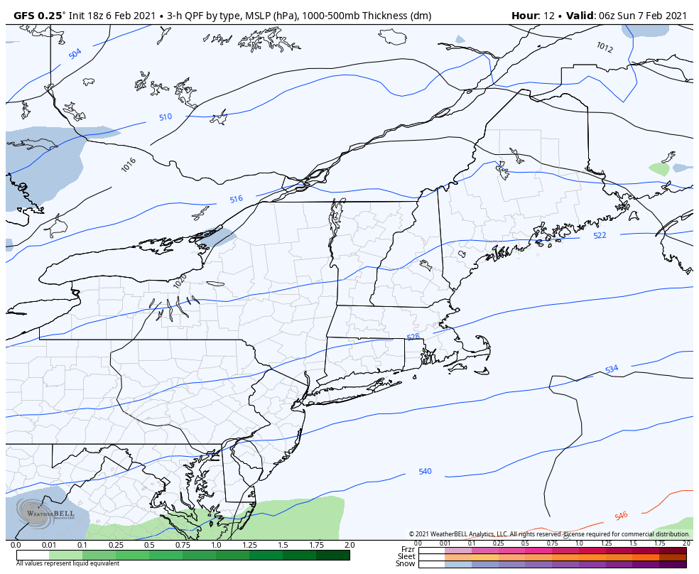
Well, things have changed. Low pressure will move off the Mid-Atlantic coastline tonight, and pass south and east of Nantucket on Sunday, farther north than we were thinking on Thursday. This will result in accumulating snow for most of the region, with this ending up as a moderate snowstorm far parts of southeastern Massachusetts.
Low pressure will pass south and east of the region on Sunday. Loop provided by WeatherBell.
Snow will develop from southwest to northeast during the morning, and from late morning into mid-afternoon, snow may be moderate to heavy at times, with snowfall rates of 1 inch per hour or more. The snow will start to wind down by late afternoon or early evening, just in time for the Super Bowl to begin. For most of us, this will be just a snow storm. However, for parts of Cape Cod and the Islands, there is a chance that some sleet or rain could mix in, which would keep accumulations down slightly.
So, how much are we expecting?
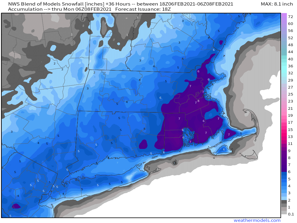
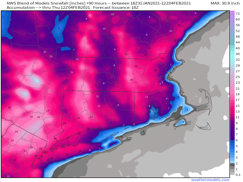
Central NH (Manchester/Concord): 2-4″ Southern NH/North-Central MA: 3-5″ NH Seacoast/Merrimack Valley: 4-7″ The Rest of Eastern MA/RI: 5-9″, except 3-6″ across the Outer Cape and Islands and the immediate east coast of MA
The NWS Blend of models is probably closest to our thinking right now. Image provided by Weathermodels.com
As was pointed out to us by a colleague for parts of Southeastern Massachusetts, this will be one of the biggest storms this area has seen in a few years. Using Middleboro as an example. they have only received 6 or more inches from a single storm twice in the last 3 years – 6.5″ December 2-3, 2019, and 8.5″ on March 4, 2019.
Beyond this, our next chance for some snow will be with another weak system on Tuesday. That storm will produce a little light snow, possibly rain south of Boston. However, given the performance of the models more than a day or two out, would you really be surprised if it becomes something bigger? We’ll have more on that in our Weekly Outlook Monday morning.
March is supposed to come in like a lion, and it still may, but for now, February is going to as well.
As you may have heard, it’s going to snow today. We’re not going to rehash that too much, since we just wrote a very detailed post about the storm Sunday evening, and our thinking really hasn’t changed much. Suffice to say, snow will become heavy at times this afternoon and tonight, changing to rain for the immediate coast and Cape Cod. It’ll start to wind down early Tuesday, but occasional snow showers and periods of light snow continue on Tuesday with rain eventually going back to snow near the coast. Strong winds this afternoon and tonight slowly diminish on Tuesday as well.
The NWS Blend of Models is still closest to our thinking with snowfall for the current storm. Image provided by Weathermodels.com
So, let’s get to what comes next. On Wednesday, the storm pulls away, heading towards Nova Scotia, but we may still have a few snow showers around, especially during the morning. Skies may start to clear out late in the day. The airmass behind the storm isn’t that cold, so unlike past storms, we don’t have to worry about another arctic blast freezing everything up. High pressure then builds in for Thursday and the sun should return, with temperatures right around where they should be in early February.
Average high temperatures in early February are in the middle to upper 30s across the region. Image provided by Weathermodels.com
Friday and the weekend are when things get interesting again. You may recall a few days ago when some of the tv meteorologists were talking about a big warmup and rainstorm around here for this coming Friday, which would help get rid of a lot of the snow we’re getting today. Well, that’s not quite what’s going to happen now. Yes, low pressure will still travel into the Great Lakes and then Ontario, passing well north and west of us, and temperatures will moderate a bit on Friday. However, temperatures will likely only get into the upper 30s to lower 40s, which is still a little above normal, but not the 50s some of the models were showing a few days ago. We’re also not looking at a lot of rain either. There will likely be some precipitation ahead of a strong cold front, and much of it will be rain, but it might not start as rain across the interior.
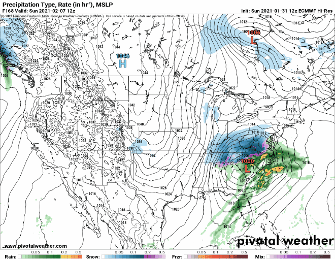
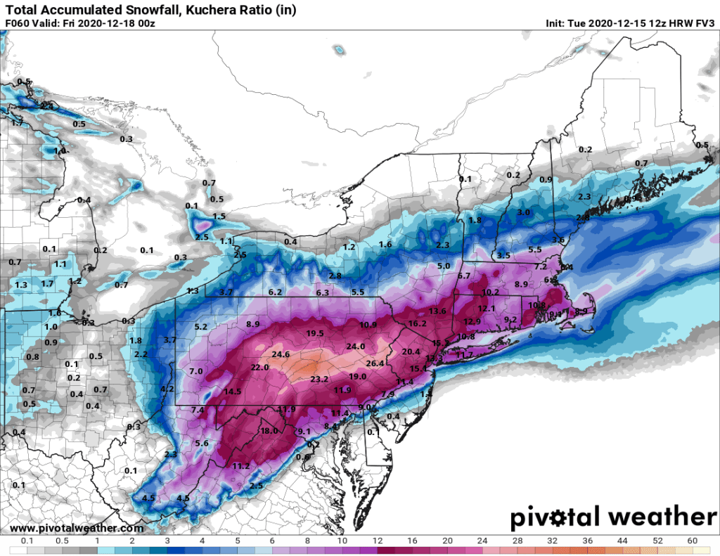
The cold front moves through Friday night and high pressure starts to build in with colder air once again. It won’t be as cold as what we had this past weekend, but temperatures will be near to perhaps a little below normal. That’s not the end of the story though. That cold front likely stalls out across the Southeast and then a wave of low pressure will move out of the Gulf of Mexico and start to ride up along the front. Some of the models are showing the potential for that system to bring in some more snow next weekend. It’s still 6-7 days away, and most of the models have not performed that well beyond 2-3 days for quite some time, so we’re not completely convinced of this yet, but it’s something we’ll start to focus on once we get our current storm out of the way. If it starts looking more likely, we’ll have more details in our Weekend Outlook Thursday afternoon.
The models have lots of differences in timing and track of a potential system next weekend. Images provided by Pivotal Weather.
Monday: Becoming windy with snow, heavy at times by late afternoon, changing to rain along the coast. High 28-35.
Monday night: Windy with snow, heavy at times inland, and rain from Cape Cod and parts of southeastern and coastal Massachusetts. Precipitation tapers off toward daybreak. Temperatures hold steady or rise a few degrees overnight.
Tuesday: Cloudy and breezy with periods of light snow and snow showers, except rain showers for southeastern Massachusetts. High 30-37, a little warmer across Cape Cod and possibly southeastern Massachusetts.
Tuesday night: Cloudy and breezy with additional snow showers possible. Low 21-28.
Wednesday: Cloudy with a few more snow showers possible early, some glimpses of sunshine are possible in the afternoon. High 29-36.
Thursday: Partly to mostly sunny. High 32-39.
Friday: Cloudy and breezy with showers developing, possibly starting as snow or a wintry mix north and west of Boston. High 38-45.
Saturday: Some early sun is possible otherwise mostly cloudy with a chance of snow or rain. High 33-40.
Sunday: Mostly cloudy with snow or rain possible. High 32-39.
We really haven’t had a decent-sized snowstorm around here since mid-December. That will change in a hurry on Monday. As a result, the Extreme Hype Watch we issued on Thursday has been upgraded to an Extreme Hype Warning.
Low pressure moving across the Ohio Valley this afternoon is just one ingredient in the mix for the upcoming storm. Image provided by the Weather Prediction Center.
High pressure remains in place across Quebec, keeping plenty of cold air in place across the Northeast this afternoon. Meanwhile, low pressure is moving across the Ohio Valley, producing a swath of snow from the Great Lakes into the Mid-Atlantic states. As that low moves eastward, it will weaken tonight, but a new area of low pressure will develop off the Mid-Atlantic coastline. At the same time, and upper-level low pressure area will also move toward the East Coast. As the new surface low gets caught underneath the upper-air low pressure area later Monday and Monday night, it will stall out or meander around south of Long Island. Eventually, it will resume an east to northeast motion on Tuesday, passing south and east of Nantucket before moving into the Gulf of Maine.
Snow is falling from Chicago to New York City late this afternoon. Loop provided by Weathertap.
As we mentioned, an Extreme Hype Warning has been issued, which means you’ll see blanket coverage from the network stations around here, hourly updates even when they go to regular programming, and of course, obligatory live shots from (take your pick):
The side of an Interstate
Logan Airport
A local DPW salt pile
A beach showing the rough surf and coastal flooding
A Dunkin Donuts where they are talking to a plow operator
All of the above
You’ll also get network reports about how the snow is creating chaos in New York City, how it put Washington at a standstill, and possibly how it dumped heavy snow on the Midwest. The latter is debatable, because anything west of the Appalachians is considered “flyover country” to the media around here.
OK, we’ve explained what’s going on in the big picture, now let’s focus on some of the details for our area (Southern New Hampshire, Eastern Massachusetts, Rhode Island):
Winter Storm Warnings are in effect from Maine to Virginia.
As you can see on the radar above, snow is already moving into the Tri-State area, and will continue to make slow progress northward tonight. By morning, east to northeast winds will start to increase around here, and we’ll see some ocean-effect snow showers develop in parts of southern New Hampshire and eastern Massachusetts. These aren’t directly related to the storm, but may drop 1/4-1/2″ of snow. This is also a common occurrence before some storms around here. The snowfall from the storm will move in during the late-morning and early afternoon hours and should become moderate to heavy by late afternoon or early evening. Snow may fall at the rate of an inch or two per hour at times. This will continue overnight with precipitation starting to taper off before daybreak. For much of the region, that precipitation will fall as all snow, but a change to rain is likely along the coast and across parts of southeastern Massachusetts and southern Rhode Island. How far inland that rain-snow line penetrates will obviously have a large impact on accumulations. Right now, we don’t expect it to get past Interstate-95, and it might not even get that far.
By Tuesday morning, the steady precipitation will taper off, but the storm will still be south of Long Island. So, what we’re looking at is occasional snow showers and periods of light snow throughout the day, with rain or mixed precipitation in southeastern Massachusetts and southern Rhode Island, This likely won’t add too much accumulation, but in some places, we could see another inch or two. As the low finally gets moving, colder air will work its way back in, changing everywhere back to all snow before it ends late Tuesday night or Wednesday morning.
There are several factors that could cause problems around here. First and foremost is the wind. Northeast winds will increase to 15-25 mph inland, and 20-30 mph along the coast, with gusts of 30-50 mph. This will create near-blizzard conditions at times Monday night, with reduced visibility and blowing and drifting snow. If you don’t have to go out Monday night, stay home. Driving will be extremely hazardous. Across Cape Cod and the Islands, a High Wind Warning is in effect. Sustained winds of 25-35 mph with gusts to 60 mph are possible here. Winds will only slowly diminish across the region on Tuesday.
Peak wind gusts of 40-50 mph are expected across the region. Image provided by WeatherBell.
Along with the wind, we have coastal flooding to worry about. A Coastal Flood Watch is in effect for eastern Massachusetts, mainly for the high tide cycles Monday night and Tuesday morning. Those strong northeast winds, combined with tides that are still astronomically high, will likely produce some coastal flooding, especially in some of the normally prone areas (like Morrissey Boulevard in Boston). By Tuesday afternoon, winds will become more northerly, reducing the coastal flood threat.
Finally, we get to the part you’re all interested in – how much snow? The good news is that they heaviest snow from this storm will likely be south and west of us, from southeastern New York and northern New Jersey into parts of Pennsylvania. Many locations in this area could see 20 or more inches of snow before everything winds down. Even New York City could see a foot to perhaps a foot and a half of snow. Around here, there will likely be many reports in excess of a foot, especially north and west of Boston. As for specifics, here’s what we’re thinking:
Cape Cod: 1-3″, heaviest near the Canal South Coast/Immediate East Coast: 3-6″ Interior Southeastern Massachusetts/I95 Corridor from RI into Eastern MA: 6-10″ Areas North and West of Interstate-95 (including southern/Central NH): 10-15″ with some heavier amounts possible.
Our thinking is closest to what the NWS Blend of Models is showing. Image provided by Weathermodels.com
Obviously, some of these amounts are dependent on when/if rain starts to mix on or a complete change to rain occurs. Most of the accumulating snow will occur between late Monday afternoon and daybreak Tuesday, but there will still be some snow falling during the day on Tuesday.
Another storm will move in late this week, but this one looks to be milder, with rain for a bigger chunk of the region, though snow is a possibility across the interior. We’ll have more on that in our Weekly Outlook tomorrow morning.
We’ve got a couple of busy days coming up, and not just because it’s Christmas.
Low pressure is moving across Iowa this afternoon, producing blizzard conditions across parts of the Upper Midwest and Northern Plains. That system will impact us over the next few days, but in a different way. As it moves toward the Great Lakes, it will start to send milder air into the region tonight, but more noticeably tomorrow. Southerly winds will gradually increase tomorrow, becoming quite strong tomorrow night and into Christmas morning. Sustained winds of 15-30 mph are likely, with wind gusts to 50-60 mph or more possible. This could result in power outages, so don’t be surprised if you wake up Christmas morning and can’t charge up those new electronics you found under the tree.
Damaging wind gusts are possible across much of the region Thursday night and Christmas morning. Image provided by WeatherBell.
Wind isn’t the only issue we’ll have. Rain will move in Thursday night, and continue into Christmas Day. While it may not be raining the entire time, there will be some bands of heavy rain, with rainfall totals in excess of an inch possible in many areas. The rain, combined with temperatures climbing above 50, will help to melt a lot of the snow that is on the ground. This could result in some flooding issues in some spots, but widespread flooding doesn’t look likely.
The ECMWF shows how our snow cover could quickly disappear over the next few days. Loop provided by Weathermodels.com
As this storm system moves into southeastern Canada, it will drag a strong cold front across the region on Christmas Day. Although the day will start mild, likely in the 50s for most of us, temperatures will drop during the afternoon. If the cold air moves in fast enough and the precipitation is slower to move out, we could even see some wet snowflakes before everything winds down late in the day. At night, temperatures will continue to drop, meaning that the wet roads will likely start to ice over if they are not treated, as they won’t have had much time to dry before the cold air moves in.
The GFS model shows the warmer air move in on Christmas Eve, then quickly get replaced on Christmas Day. Loop provided by WeatherBell.
High pressure builds in for the weekend with dry and seasonably cold conditions. It may still be a bit breezy on Saturday, adding to the chill, but Sunday may also be a few degrees milder. By Monday, we’ll be watching another storm system passing to our west, with some showers possible.
Wednesday night: Becoming partly to mostly cloudy. Low 23-30 this evening, but temperatures may start to rise a bit after midnight.
Christmas Eve: Mostly cloudy, becoming breezy in the afternoon. High 48-55.
Thursday night: Cloudy and windy with showers developing, becoming steady rain late at night. Temperatures gradually rise overnight.
Christmas Day: Cloudy with rain likely, possibly heavy at times, windy in the morning. High 53-60 in the morning, temperatures drop during the afternoon.
Friday night: Mostly cloudy and breezy with any lingering showers ending in the evening, possibly mixed with a few wet snowflakes, some clearing is possible late at night. Low 22-29.
Saturday: Becoming partly to mostly sunny. High 28-35 (welcome back to December).
Saturday night: Clear skies. Low 19-26.
Sunday: Partly to mostly sunny. High 32-39.
Sunday night: Increasing clouds. Low 22-29.
Monday: Mostly cloudy and breezy with a few showers possible. High 42-49.
After several days of media hype, and people posting model forecasts for extreme amounts of snow on social media, it looks like we do actually have a snowstorm on the way, and it could be a decent-sized one for parts of the region.
High pressure over Ontario and low pressure over Texas are two things we need to pay attention to for the next day or two. Image provided by NOAA.
Low pressure over Texas this afternoon will combine with a second area near the Texas coast to become a single storm system later today, which will then head northeastward into the Tennessee Valley tonight, bringing plenty of moisture with it from the Gulf of Mexico. Meanwhile, a strong high pressure system is moving across southeastern Canada, bringing plenty of cold air into the Northeast. When you get copious amounts of moisture running into cold air, you end up with snow, potentially a lot of it,. That’s what’s going to happen here late Wednesday into Thursday.
Winter Storm Watches are in effect for all of Southern New England. Image provided by Pivotal Weather.
That low pressure area will move from the Tennessee Valley to the Mid-Atlantic coastline on Wednesday before moving offshore and passing south of New England. While there are still some questions as to the exact track it will take, which has implications for the forecast itself, the models have come into better agreement today on a more northerly track than they were showing last night. This has several implications for the forecast around here:
1. Snow will likely penetrate even farther inland, with heavier snow farther inland as well. 2. Rain/snow ratios will be lower across southeastern New England, resulting in a wetter snow. 3. A change to sleet or rain is now possible across Cape Cod, and possibly parts of southeastern Massachusetts and southern Rhode Island.
We mentioned in our Weekly Outlook that there would likely be a sharp cutoff in the northern extent of the snow, going from heavy snow to little snow in a short span, but we weren’t sure where that cutoff would set up. At this point, it’s looking more and more likely that it will set up somewhere in central or southern New Hampshire, meaning that most of us will be shoveling by Thursday morning. This detail is still not definite, so obviously things can change in the next 24 hours or so.
Plenty of cold air will be in place before the storm moves in. Image provided by Weathermodels.com
That high pressure area in southeastern Canada will provide us with plenty of cold air, which will be evident tonight when temperatures drop into the teens or even single numbers. As the snow moves in Wednesday night, we’ll see a coastal front setup across eastern Massachusetts and Rhode Island. This is a common occurrence in winter storms. Basically, the northeast to east winds off the water send temperatures up to the lower to middle 30s along the coast and a short distance inland (anywhere from 20-40 miles). On the other side of that front, northeast to north winds keep the colder air locked in, with temperatures in the teens and lower 20s. Obviously, in the “milder” air on one side, you’ll get a wetter snow, with the possibility of some mixed precipitation, while the colder area gets mostly snow that is more powdery. We said “mostly snow”, as you can get some milder air aloft which could allow for some sleet to mix in, which obviously would have a significant impact on snow accumulations. That coastal front will eventually collapse southeastward toward the coast as the low pressure area moves by, allowing the colder air to eventually move back in everywhere, and any mixing that does take place eventually goes back over to all snow.
The snow to rain ratio varies by temperature, as this chart shows. Image provided by Weathertrends360.com
As for the timing, most of Wednesday should be fine, so you can do any errands that need to be completed before the storm moves in. Snow should move into the South Coast towards the evening rush, quickly spreading northward, reaching the MA/NH border by midnight. Snow may fall moderate to heavy at times overnight, with some mixing possible across Cape Cod and the Islands (and possibly southeastern Massachusetts) late at night and early Thursday morning. Most of the steady precipitation should wind down by midday, but some lingering snow showers are possible, especially along the coast, through the afternoon.
Snow isn’t the only threat with this system, as gusty winds are also expected, especially along the coastline. While this storm won’t be that strong, at least compared to many winter storms in the past, the gradient between it and the large high pressure area to the north will create some gusty winds. Sustained winds of 15-25 mph, with gusts to 40 mph or more, are likely. These gusty winds may enhance the snow across parts of eastern Massachusetts. However, with high astronomical tides, the winds may also result in some coastal flooding around high tide, especially at northeast and east facing coastal areas.
Wind gusts to 40 mph or more are possible, especially along the coast. Image provided by WeatherBell.
So, how much snow are we looking at? Obviously, there’s still some things that complicate this part of the forecast (snow ratios/mixing/northern extent of the snow), so this is preliminary for now, and we may adjust it tomorrow if needed, but here’s our thinking:
Central New Hampshire: 2-4″ Southern New Hampshire/Seacoast: 4-8″ Merrimack Valley/Central Massachusetts: 5-10″ North Shore/MetroWest/Metro Boston: 6-12″ Interior Southeastern Massachusetts/Rhode Island: 8-14″ Cape Cod and the Islands: 4-8″
This model is probably closest to our thinking on snow accumulations at the moment. Image provided by Pivotal Weather.
Colder air will settle back into the region behind the storm for Thursday night and Friday, so you’ll want to clear out the driveways and walkways before everything freezes solid.
Hope you enjoyed the 60-degree temperatures on Sunday, because changes are coming. It’s going to snow this week, likely more than once for many of us.
Sunday was a mild day across most of the region. Image provided by NOAA.
A cold front moved across the region overnight and is now south of us. Low pressure will move off the Mid-Atlantic coastline and ride along that frontal system today. Precipitation will move in towards midday and continue through the afternoon, ending in the evening. Temperatures will be near or above freezing, so we’ll see a mix of rain and snow, likely changing over to snow before ending in many areas as colder air filters in behind the system. We’re not expecting much accumulation, mainly an inch or so, and mainly south of the Mass Pike. A few places could see up to 2 inches in heavier bursts, but overall this isn’t a big deal. However, since it will fall during the afternoon, it could make a mess of the afternoon commute, so keep that in mind if you are not working from home. North of the Mass Pike, we’re only looking at some flurries, if that, with the ground getting coated in some locations.
Not much snow is expected today, but the timing will make it a bit more impactful. Image provided by WeatherBell.
That storm will move into Atlantic Canada on Tuesday, and strengthen into a powerful storm system. Gusty northwest winds behind the storm will usher much cooler air in for Tuesday and Wednesday as high pressure moves into southeastern Canada. This will become important as we head into later Wednesday and Thursday as the next storm system moves towards the area.
Wednesday morning could be rather chilly across the region. Image provided by Weathermodels.com
As you’ve no doubt heard by now, a rather strong storm system will impact the East Coast later Wednesday into Thursday. With high pressure to the north, we’ll have plenty of cold air in place, so anything that does fall will almost certainly fall in the form of snow. As the storm strengthens, it will produce gusty winds in some areas, which combined with the high astronomical tides, could result in some coastal flooding, especially east and northeast-facing locations. Beyond that, there’s a lot of uncertainty. That storm that moved into Atlantic Canada will not move too much, and it will have an impact on the track our mid-week storm takes. Another factor will be the high pressure area to our north. It will try to send cool and dry air southward into the region. This will likely result in a sharp cutoff of the precipitation, going from heavy snow to virtually no snow over a relatively small area. Where that cutoff sets up is also still in question. The models, while in general agreement that a powerful storm will move off the Atlantic Coast and south of New England, differ on some of the finer details, which have an enormous impact on the forecast. It’s still WAY too early to pin down any specifics, so we won’t bother to attempt it. We’ll just say that the potential exists for a significant snowstorm across the region from late Wednesday into Thursday. Beyond that, we’ll offer more details in a special blog post on Tuesday.
Differences among the models can have a big impact on the forecast for the storm around here. Images provided by Pivotal Weather.
Behind the storm, high pressure builds back in for Friday and Saturday with dry and chilly conditions. If there’s fresh snow on the ground, some places could get quite chilly at night, especially Thursday night and Friday night. By Sunday, the high moves offshore and temperatures will start to moderate. However, another system may bring in some rain or snow. We’ll worry about that one after we get through the first two.
Monday: Cloudy with rain or mixed precipitation developing around midday, eventually changing to light snow by late afternoon. High 32-39.
Monday night: Light snow ends in the evening, then skies clear out overnight. Low 23-30.
Tuesday: Sunshine and some afternoon clouds, breezy. High 28-35.
Tuesday night: Clear during the evening, clouds move in late at night. Low 12-19.
Wednesday: Cloudy and becoming breezy with snow possible late in the day and at night. High 24-31.
Thursday: Cloudy and windy with snow likely, ending during the afternoon. High 24-31.
Friday: Partly to mostly sunny. High 27-34.
Saturday: Sunny in the morning, clouds return in the afternoon. High 30-37.
Sunday: Cloudy with a chance of rain or snow. High 37-44.
The first snowstorm of meteorological winter is expected across at least part of the region on Saturday.
Low pressure is moving into Tennessee this afternoon, on its way toward the Northeast. Image provided by the Weather Prediction Center.
Low pressure moving into the Tennessee Valley this afternoon will cross the Appalachians tonight and move off the Mid-Atlantic coastline on Saturday. Ahead of it, rain will move into our area tonight, and it could be heavy Saturday morning. Given our long-term rainfall deficit, this is a good thing. However, some localized flooding is possible, especially in areas where the storm drains are covered or clogged by fallen leaves. This is the easy part of the forecast.
Rainfall totals of 1-2 inches are possible across much of the area from this storm. Image provided by Weathermodels.com
As the system moves northeastward, an upper-level disturbance will drop southeastward from Canada. This disturbance and the system to the south will eventually phase, resulting in a fairly strong storm system off the East Coast. There is still some question to the exact track the system takes, but it will likely pass close to or just south of Cape Cod and the Islands. As the system intensifies, it will generate some strong winds, especially along the coast south of Boston. High Wind Watches have been posted along the coast in this area, where sustained winds of 25-35 mph are expected, with some gusts to 50 mph or more possible.
Wind gusts of 50 mph or higher are possible along the coast late Saturday and Saturday night. Image provided by WeatherBell.
As the storm passes by our longitude, it will turn winds from the northeast to the north and eventually northwest. This will help bring colder air down from the north. The airmass to the north isn’t that cold by December standards, but temperatures will drop below freezing, which will allow for the rain to change over to snow from northwest to southeast as the low passes by. The exact track of the storm will determine exactly where the rain/snow line ends up. A track farther to the north and west results in less snow to the south and east.
The models still have a wide variety of ideas for how much snow is expected and where it will fall. Images provided by Pivotal Weather.
When that changeover occurs also will have a big impact on the snowfall amounts. Right now, here’s our thoughts on the changeover timing:
Late morning: The higher terrain from central Massachusetts into southwestern New Hampshire Midday/Early Afternoon: Southern New Hampshire Early/Mid Afternoon: Merrimack Valley and New Hampshire Seacoast Late Afternoon: MetroWest and the North Shore as well as Northern Rhode Island Early Evening: I-95 corridor from Boston to Providence and parts of Southeastern Massachusetts.
Everything should wind down and end by midnight as the storm moves into the Gulf of Maine and pulls away from the area.
Beyond the timing and track issues, we have one more thing that complicates the snowfall forecast. As the system gets cranked up, bands of very heavy snow will develop. Some of these bands may produce 1-2 inches of snow in an hour. Exactly where those bands set up is nearly impossible to determine in advance, and even trying to figure out a general area for them is tough, because part of it will depend on the track of the system.
Having said all of that, here’s our best estimate right now for snowfall:
Dusting (if that): Cape Cod and the Islands 1-2″: Southeastern Massachusetts and Southern Rhode Island 2-4″: I-95 corridor from Boston to Providence 3-5″: Northern Rhode Island/MetroWest/North Shore/New Hampshire Seacoast 4-7″: Merrimack Valley/Southern New Hampshire 5-9″: Worcester County/Southwestern New Hampshire
Obviously this is a low-confidence forecast, based on all of the factors above, but it’s our best guess at the moment. If there’s any significant changes, we may do another quick update Saturday morning/early afternoon.
The next few days after the storm look calmer, but another system will develop off the East Coast on Tuesday. Right now, it looks like it will stay too far south and east to have any impacts here, but we’ll keep an eye on it.
It looks like we’ve got some snow coming in this weekend for at least part of the region, but that’s only part of a complex forecast for the next few days.
High pressure will slide offshore later today and tonight while clouds start to stream in ahead of a cold front. That front may produce a few showers on Friday, but most of us will just see some clouds as the front moves through. However, this will set the stage for the next storm.
Enjoy the mild weather on Friday, because changes are coming. Image provided by Weathermodels.com
Low pressure currently near the Louisiana coastline will head northeastward tonight, moving up the Appalachians on Friday, then off the Mid-Atlantic coastline on Saturday. At the same time, an upper-level disturbance in Canada will dive southeastward. As these two systems meet up or “phase”, they will create a strengthening low pressure system. The track of that low will determine several things, but the two main ones are how much precipitation will fall, and whether it will be rain or snow. Most of the models bring the storm near Cape Cod or just south of it, but there are others that bring it across southeastern Massachusetts. The farther north and west the low travels, the farther north and west the rain/snow line ends up.
There are still some significant differences among the models for the weekend storm. Images provided by Pivotal Weather
Before we get too far ahead of ourselves, let’s get to what we are fairly sure about. Rain will develop across the region early Saturday morning, and may fall heavy at times during the day on Saturday. This will help put another dent in our long-term rainfall deficit. As the low passes by, northerly winds will bring cooler air into the region. There’s not a lot of “cold” air to begin with, but temperatures will likely drop to near or below freezing, which will allow for a changeover to snow, at least north and west of Boston. That changeover is likely to occur Saturday night, but at least one model has it change over much earlier – during the afternoon. Others only have the changeover occur as the precipitation winds down and ends Sunday morning, and at least one other doesn’t have it changeover at all. Obviously when that changeover occurs will have an impact on how much snow (if any) accumulates.
Whether it’s all rain or rain to snow, this will be another heavy precipitation producer. Image provided by WeatherBell.
Right now, we’re expecting a change to snow from northwest to southeast Saturday evening and night, with everything winding down around daybreak Sunday. The snow could be heavy at times during Saturday evening, but should taper off at night as the system starts to pull away. Several inches could accumulate well north and west of Boston, but this is still a bit uncertain. We’re not going to forecast any amounts yet, as there’s not enough confidence yet to come up with specific amounts. We’ll do another blog post just on the storm tomorrow, and at that point we’ll have a specific snowfall forecast.
Skies should start to clear out Sunday afternoon as gusty west to northwest winds will bring drier air in behind the storm. High pressure will start to build in on Monday, but with an upper-level low pressure system moving through, we’ll still have some clouds, and a few rain or snow showers are possible.
Friday: Mostly cloudy, becoming breezy, chance for a few showers, mainly south of the Mass Pike during the afternoon. High 49-56.
Friday night: Cloudy with some showers developing. Low 35-42.
Saturday: Cloudy and windy with rain, heavy at times, changing to snow from central Massachusetts into southern New Hampshire late in the day. High 39-46 early (47-54 across Cape Cod and the Islands), then temperatures drop during the afternoon.
Saturday night: Cloudy and windy with rain changing to snow from northwest to southeast before tapering off and ending toward daybreak. Low 25-32, a little milder across Cape Cod and the Islands.
Sunday: A few lingering rain or snow showers early, then clearing in the afternoon, breezy. High 33-40.
Sunday night: Clear to partly cloudy. Low 19-26.
Monday: A mix of sun and clouds, slight chance for a rain or snow shower. High 32-39.
A rather potent storm system will bring a variety of weather to the eastern third of the United States over the next few days.
Low pressure is developing along a frontal system in southern Texas this evening. Image provided by the Weather Prediction Center.
Low pressure developed along a frontal system in southern Texas on Saturday, and it will slowly strengthen as it moves northeastward tonight and Sunday. As it strengthens, it will draw moisture northward from the Gulf of Mexico, while colder air continues to move southward behind the storm system. This will set the stage for a couple of rather active days across the Eastern third of the nation, with several different types of weather likely.
The GFS model shows the progression of the storm over the next few days. Loop provided by Tropical Tidbits.
The biggest threat initially will be severe weather. As the warm, moist air flows northward from the Gulf of Mexico and clashes with the colder air moving in behind the storm, strong to severe thunderstorms are possible. A few storms are possible overnight in parts of Texas and Louisiana, but the threat will shift into the Gulf Coast on Sunday, parts of the Southeast and the Carolinas Sunday night, and parts of the East Coast from Florida to the Mid-Atlantic states on Monday. Some of the stronger storms may produce heavy downpours, damaging winds, and possibly some tornadoes.
Strong to severe storms are possible from the Gulf Coast into the Carolinas on Sunday. Image provided by Pivotal Weather.
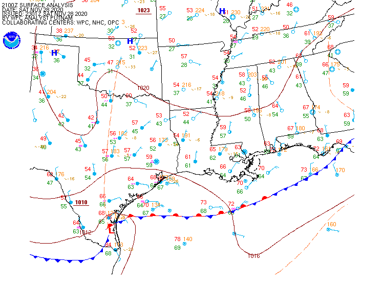
While severe weather is not common at this time of year, it is certainly not unheard of. In fact, Saturday marked the 32nd anniversary of one of the strongest tornadoes on record to hit North Carolina. On November 28, 1988, an F4 tornado tore an 84-mile path of damage across parts of North Carolina, including the city of Raleigh.
#OTD the 1988 Raleigh EF4 tornado tore an 84 mile path of destruction through central NC. While it's getting colder, severe weather is still possible and worth keeping in mind with a storm system moving in Sun night into Mon. Have memories of this event? Share them below! #NCwxpic.twitter.com/uoapXwtaTp
As the storm moves up the Appalachians it will bring unseasonably mild air to the East Coast, but also some heavy rainfall. Temperatures will be in the 60s and 70s across the Gulf Coast and Southeast on Sunday. By Monday, 60-degree readings will be possible as far north as southern New England, with some 70s into the Carolinas and parts of southern Virginia. The mild air may linger into Tuesday across parts of New England as well. While these temperatures are 10-20 degrees above normal, they will likely fall short of the record highs in most locations.
Monday will be a warm day by November standards up and down the East Coast. Image provided by WeatherBell.
The warm weather will be transported in by strong southerly winds ahead of the system. Sustained winds of 25-35 mph will be common up and down the East Coast. Many places could see wind gusts of 50-60 mph or stronger, which could lead to power outages as trees and wires come down.
Wind gusts in excess of 50 mph are possible across the East Coast ahead of the storm. Image provided by WeatherBell.
In addition to the warm weather, heavy rain is likely for much of the East. The warm, moist air being drawn northward from the Gulf of Mexico will be deposited up and down the East Coast later Sunday into Monday, and early Tuesday for parts of New England. Rainfall totals of 1-2 inches will be common, with some places possibly picking up 3 inches or more, especially in parts of eastern New England. While this will help put another significant dent in the long term drought that the region is experiencing, too much rain at once will likely lead to flooding in some areas.
Heavy rain is likely across the East Coast Monday into Tuesday. Image provided by Weathermodels.com
While all of this is going on ahead of the storm, a different scenario will be evolving on the storm’s back side. Colder air flowing southward from Canada will clash with the warm air, resulting in snow across parts of the Great Lakes and the Appalachians. The snow will be accompanied by gusty winds, lowering visibility in many locations, resulting in very hazardous driving conditions. While the snow won’t be exceptionally heavy, many places could receive upwards of 4-8 inches by the time everything winds down. Across the higher elevations of the Appalachians, even into the southern Appalachians, some heavier amounts are possible as well. As the systems gets caught under an upper-level low pressure system in southeastern Canada, it may produce some lake-effect snow into mid-week downwind of Lakes Erie and Ontario.
Accumulating snow is expected behind the storm system. Image provided by Pivotal Weather.
Once this system pulls away, things will quiet down across the East for a few days, but there are signs that another system could impact parts of the East next weekend.
September is when we start to transition from Summer to Winter, but this September is starting off with a bang.
Intense heat has been common across much of the West for the past few days. Temperatures well over 100 degrees were widespread during Labor Day Weekend, especially across California, with numerous records set. One location, Richmond, on the eastern side of San Francisco Bay, reached 107 degrees Monday afternoon, tying their all-time record, originally set on September 15, 1971. Several other locations set monthly records for September as well. The worst of the heat has passed, but it will remain hot on Tuesday, with highs likely topping 100 across much of interior California and the Desert Southwest, possibly setting a few more records. Temperatures should gradually cool down a little more as we get toward the middle and latter portion of the week.
Another hot day is likely across interior California on Tuesday. Image provided by WeatherBell.
Heat was also common across the Plains and Rocky Mountains over the weekend, but big changes are developing thanks to a strong cold front. Denver set a record high of 97 on Sunday, then reached 93 on Monday. On Tuesday, that 93 will get reversed, with a daytime high closer to 39 (The high for the calendar day will be the 46-degree reading at midnight). On top of that, accumulating snow is likely. Even by Denver standards, this is quite early in the year for snow. Their all-time record for earliest snow is September 3, 1961, but on average Denver doesn’t see its first flakes until October 18. This won’t be the 1st time that Denver hit 90 one day and then had measurable snow the next. On September 12, 1993, Denver recorded a high of 92 degrees, and on September 13, they had 5.4″ of snow.
There are 14 instances of a "major" climate station reaching 90°F one calendar day and having measurable snow the next (since 1900). Denver topped 90°F today and is forecast to have snow tomorrow. #cowxpic.twitter.com/nK7wfc7EY8
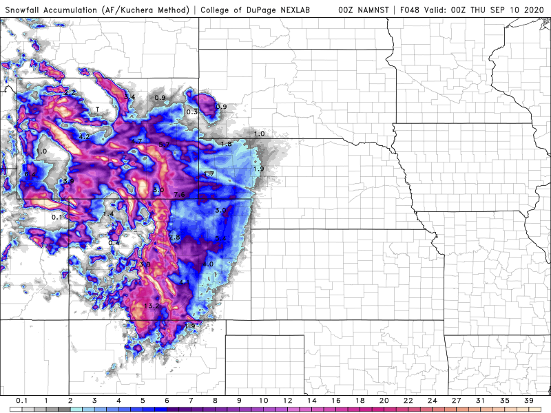
While a few inches of snow are likely in Denver and onto the adjacent High Plains of eastern Colorado and western Nebraska, heavier snow is likely across the mountains on Colorado and Wyoming. Across the higher elevations, snowfall totals in excess of a foot are likely. While the snow will likely last a while in the mountains, at the “lower” elevations on the Plains, it will disappear quickly. High temperatures in Denver will be back into the 60s by Friday, and near 80 by the end of the weekend.
Heavy snow is likely in the higher elevations of the Rockies. Image provided by the College of DuPage.
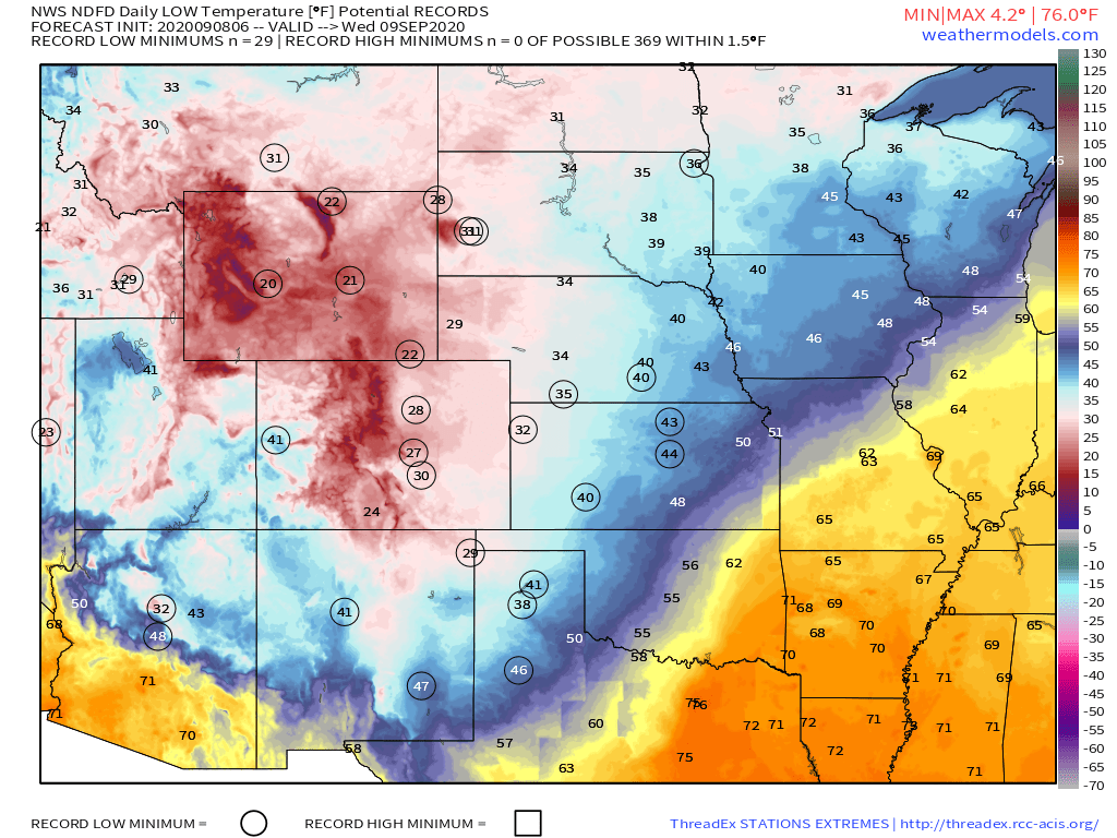
While the snow will get a lot of the headlines, the cold air behind the front will be making headlines of its own. The first frost and freeze of the season is likely across parts of the Dakotas, Montana, and northern Minnesota Tuesday and/or Wednesday morning, with lows in the upper 20s and 30s. The cold air will continue to push southward across the Great Plains during the day on Tuesday, with numerous record lows expected Wednesday morning as far south as the Texas Panhandle. The cold air will eventually spread eastward, but will be modified significantly before it reaches the Eastern United States.
Record lows are likely across the Plains and the Rockies Wednesday morning. Image provided by Weathermodels.com
While plenty of (frozen) precipitation is expected across the Rockies, the lack of precipitation is causing problems across the Northeast, specifically New England. Aside from a few showers with a cold front on Thursday, generally dry weather is expected across much of New England this week, and things don’t look that promising for much of next week either. This shouldn’t be a surprise, as precipitation has been generally below to well below normal across the region since the Spring. In some areas, the amount of rain has only been around 50-60% of normal since April 1. Drought conditions have developed across nearly all of New England, and for a good portion of the region, it is now considered a severe drought. What the region needs is a series of systems that can produce moderate rainfall to help alleviate the drought (too much at once won’t help that much), but prospects for that aren’t promising at this time. In fact, rainfall looks to remain below normal for much of the remainder of September.
Drought conditions are worsening across New England. Image provided by the National Drought Mitigation Center.
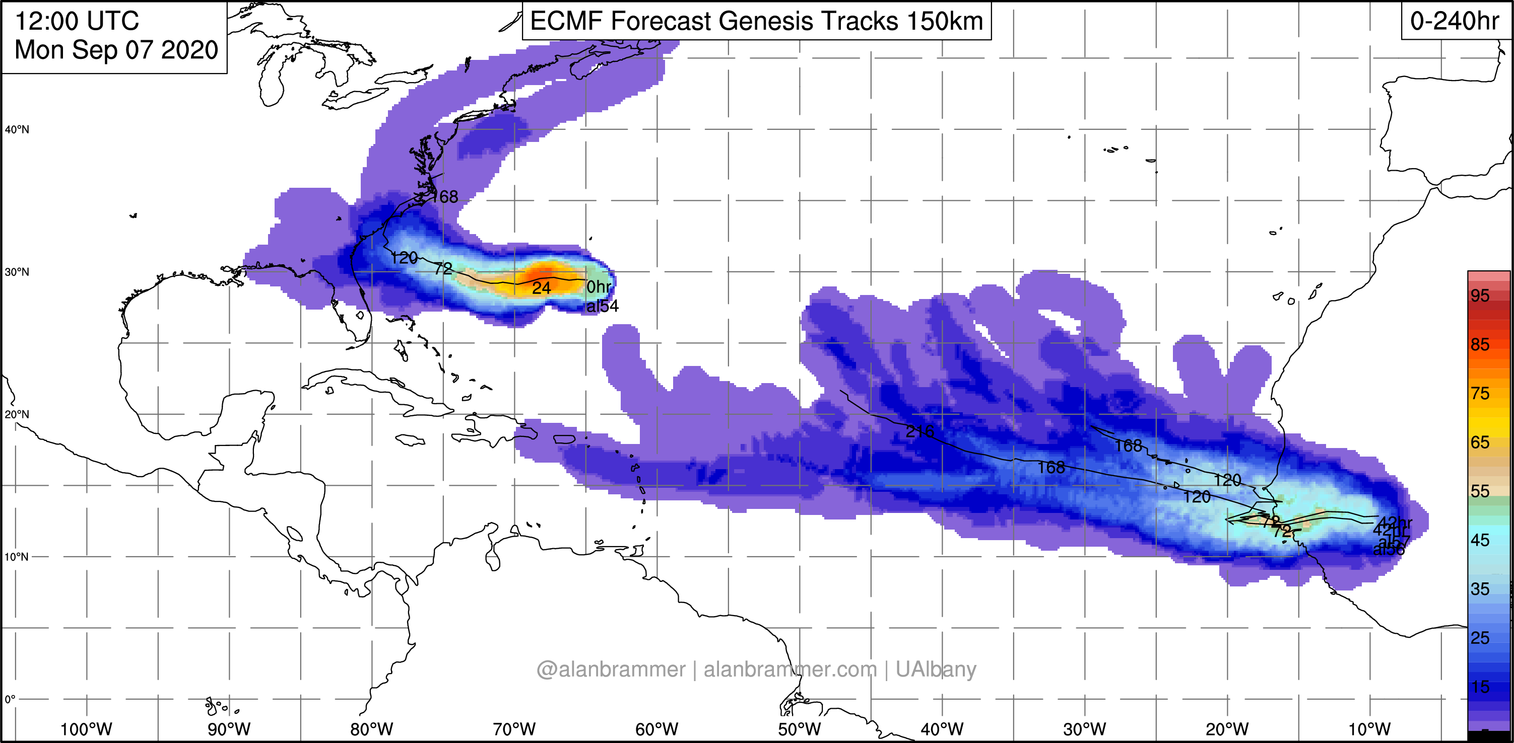
Meanwhile, as we approach the climatological peak of hurricane season, the Atlantic is once again getting more active. Tropical Storms Paulette and Rene both developed on Monday in the central and eastern Atlantic respectively. Paulette is expected to remain a tropical storm for the next several days while remaining over open water. It is not expected to be a threat to land. Meanwhile, Tropical Storm Rene moved into the Cabo Verde Islands Monday night and early Tuesday, producing heavy rain and gusty winds. It will likely strengthen over the next couple of days, possibly becoming a hurricane later this week. Once it pulls away from the Cabo Verde Islands, it is also expected to remain over open water for much of this week, presenting no additional threat to land.
Satellite loop showing Tropical Storms Paulette and Rene in the central and eastern Atlantic. Loop provided by Tropical Tidbits.
Those systems aren’t the only ones in the Atlantic that are being watched. An area of low pressure a couple of hundred miles west-southwest of Bermuda is expected to drift westward or northwestward over the next day or two. Some development of the system is possible. It may bring some rainfall into parts of the Carolinas and Southeast later this week. The other area that is being watched isn’t immediately apparent right now, as it is still over western Africa. A tropical wave is expected to emerge from the west coast of Africa later this week. Forecast models show the potential for this wave to develop rather quickly once it moves into the Atlantic. It could threaten the Cabo Verde Islands over the weekend.
The peak of hurricane season is during the middle to latter half of September. Given how active this season has been so far, there will likely be more systems developing. There are only 4 names left on this list for this season – Sally, Teddy, Vicky, and Wilfred. Once the list is exhausted, the Greek alphabet is used. This has only happened once before – in 2005. During that season, there were 28 named storms of which 15 became hurricanes.