Heat and humidity return for the first half of the week, but the latter half will tell a different story.

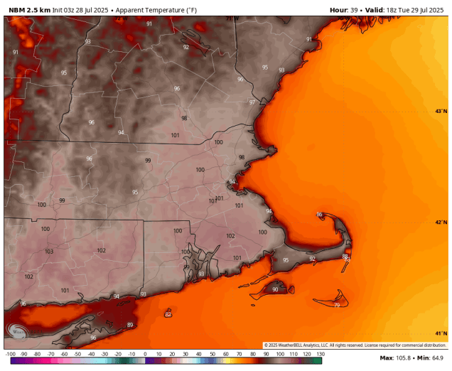
We start the week off with high pressure moving offshore, resulting in hot and humid conditions into Wednesday. Tuesday looks the be the hottest day of this stretch, with temperatures well into the 90s, and only a stray shower or thunderstorm providing minimal relief. Wednesday could also be quite hot, but we’ll have a cold front moving in, with clouds and a few showers and thunderstorms ahead of it during the afternoon. The front moves through and then stalls out near or just off the South Coast, which is where things get tricky.
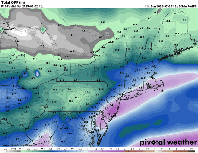
A wave of low pressure will ride along that front, bringing some rain and cooler air into the region. What’s uncertain is where the front stalls out, and the timing of the wave. For now, it looks like the bulk of the rain will be South of the Mass Pike, but that is highly uncertain. The rain could get all the way into southern New Hampshire, or it could be confined to the South Coast. This will be dependent om where the front actually is. How much rain will be dependent on how strong the wave is. Some models have light to moderate rain in spots, some show the potential for some hefty amounts. The other question is the timing. Some models show most of the rain Thursday and Thursday night, some have the heavier rain Thursday night into Friday, some even have it linger into Friday night. What you’ll see below is our best estimate on all these variables at this time, but it is obviously very low confidence. Behind the system high pressure builds in with cooler and drier weather for the weekend.
Monday: Patchy morning fog, otherwise mostly sunny, hot, and humid. High 85-92, cooler along the coast.
Monday night: Clear skies, a little patchy fog again. Low 65-72.
Tuesday: Sunshine and a few clouds, slight chance for an afternoon shower or thunderstorm. High 90-97, cooler across Cape Cod.
Tuesday night: Clear to partly cloudy. Low 66-73.
Wednesday: A mix of sun and clouds, chance for some late-day showers and thunderstorms. High 88-95, cooler across Cape Cod.
Wednesday night: Partly to mostly cloudy, showers and thunderstorms possible. Low 65-72.
Thursday: More clouds than sun with showers and thunderstorms likely. High 75-82.
Thursday night: Partly to mostly cloudy with more showers and thunderstorms. Low 58-65.
Friday: Showers and thunderstorms ending, becoming partly sunny. High 70-77.
Saturday: Lots of sunshine. High 73-80.
Sunday: More sunshine. High 78-85.
