By now, you’ve heard the TV meteorologists talking about how it’s going to snow, or you’ve read the headlines about an “historic May snowstorm” that’s coming. As usual, we at Storm HQ will avoid the hype and just give you the facts. Yes, there will be some snowflakes around here and no, it won’t be a big deal at all.
A cold front is moving across the Great Lakes this afternoon, and it move across our area tonight, with plenty of clouds and possibly a few showers. Behind that front, much colder air will start to move into the region. This is an anomalously cold airmass for early May, and in fact, is more representative of early March. That front is expected to stall out near the South Coast, and then a wave of low pressure will develop along the front and ride along it, crossing southern New England Friday night and early Saturday.

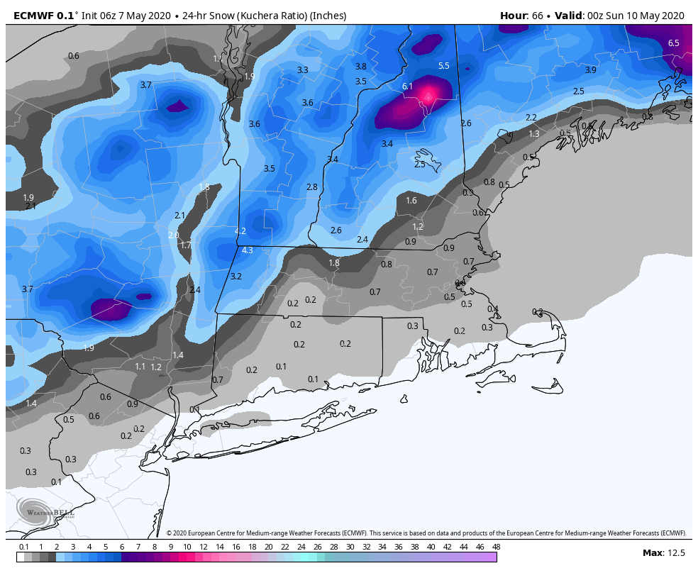
We’ll have some rain moving in Friday afternoon and evening, but as the sun sets and temperatures drop, some wet snow will start to mix in. The most likely spots for snow are in the hilly terrain from northern Rhode Island across Worcester County and into the Monadnocks of southwestern New Hampshire, as well as out in the Berkshires. However, we wouldn’t be surprised if there was some wet snow mixed in with the rain even into the suburbs of Boston.
As we mentioned with the last few storms, it’s awfully tough to get accumulating snow into early May for a variety of reasons. For one, the ground is fairly mild. Any accumulations will be mainly on grassy surfaces, as pavement temperatures are much too warm now. Secondly, temperatures may not even drop to freezing, but could stay in the middle to upper 30s. Third, the intensity of the precipitation will be key. Heavier precipitation will bring down colder air from aloft, resulting in the change to snow, whereas light precipitation will tend towards more rain.
As far as accumulations, as we said, we’re not expecting this to be a big deal for most of us. You may wake up Saturday morning, if you’re up early enough, to see a little bit of a coating on grassy surfaces, decks, and car roofs/windshields. As we mentioned, most of the accumulations will be confined to the hilly terrain, where a few inches could fall.
Snow is fairly rare once you get into May. Using data for Lowell, snow has been recorded 5 times during the month of May over the past 92 years, and measurable snow only twice.
5/11/1945 – Trace
5/1/1953 – Trace
5/10/1977 – 2.6″
5/6/1996 – Trace
5/18/2002 – 1.0″
The snow is only part of the story though, and in fact, a minor part. As the storm intensifies while pulling away on Saturday, gusty winds are expected across the area. West winds of 15-25 mph with gusts of 40-50 mph are expected, especially along the coast. At the same time, an upper-level low pressure area will be moving into the region, bringing in very cold weather. That upper low may trigger a few rain or snow showers in the afternoon, but the cold temperatures will be the story. High temperatures likely will stay in the 40s, which may set records for the lowest high temperatures for the date in many locations.

The really cold weather will be short-lived, as we will start to moderate on Mother’s Day as high pressure builds in. However, if you’re hoping for some sustained warmth, it’s not coming anytime soon. There are some hints that we may get out of the pattern that’s kept us quite chilly for most of April and early May in another 10 days or so, but a “warm” pattern is still a ways off.

The image above is the high and low temperature forecast for Bedford for the next 45 days, based on the ECMWF Ensemble, which has 51 separate members. The solid red and blue lines in the middle of each graph are the “normal” highs/lows for each day. The green dot is the average of the 51 members for each day (which is also represented numerically in the middle of the 2 charts), and the shaded gray area is the area that between 1/4 and 3/4 of the members fall. The horizontal blue lines above and below that are the extreme on each day. As you can see, this model is forecasting temperatures to remain well below normal through May 14-15. After that, temperatures generally average near or a little below normal until June 9. Granted, “normal” for those dates is upper 60s to near 70 for high temperatures, so it’ll be milder, but still a little cooler than we should be. Finally, we get to near or a little above normal for a sustained period around June 10. Now this is just one model, so take it with a grain of salt, but it’s done fairly well diagnosing the general details of our weather pattern for several weeks now. There is hope that you can finally take your summer clothes out of storage, perhaps as early as next weekend.
